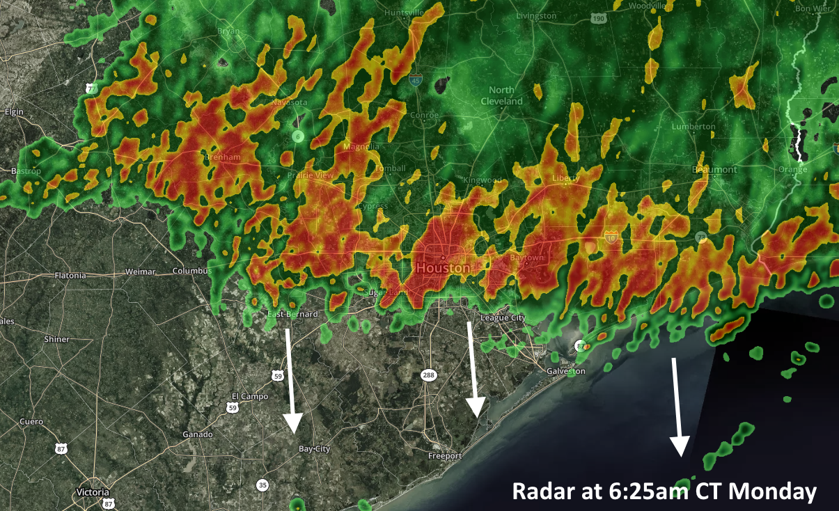
A broken line of showers and thunderstorms is pushing through Houston on Monday morning. These storms have been a little more frisky than anticipated north of the city, dropping 1 to 3 inches of rain, but they appear to be weakening as they move through central parts of the metro area toward the coast. These storms should move through Houston by mid-morning and then off the coast by or before noon. The primary threats are wind gusts above 30mph and brief, heavy rainfall. The primary benefit is cooler air thanks to a “cold pool” in the atmosphere that is helping to drive this morning’s storms. Alas, it won’t last.
Monday
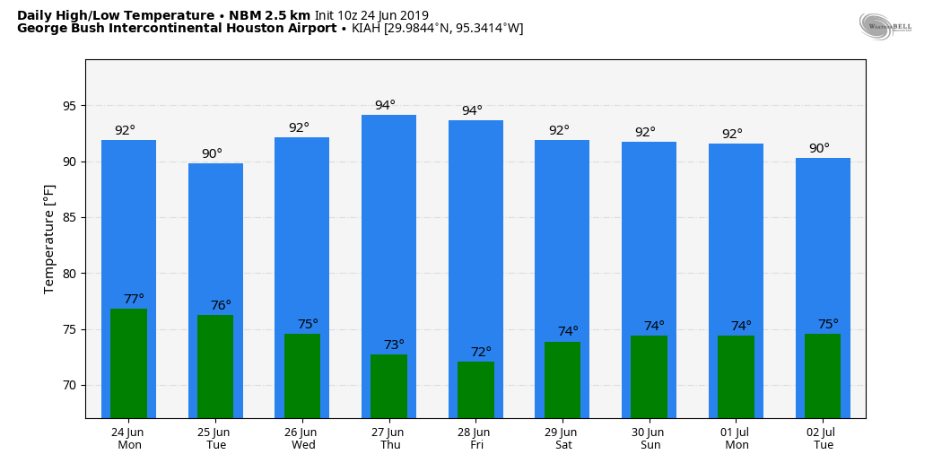
After this area of relatively unstable air moves away from Houston later this morning, rain chances should fall significantly—leaving the region with only isolated, to scattered showers for the rest of the day. Winds will remain blowy, with gusts up to about 20mph. Partly to mostly cloudy skies should help moderate temperatures for the remainder of the day, limiting them to perhaps 90 degrees or even the upper 80s. Low temperatures on Monday night may get into the upper 70s for inland areas, but we won’t see too much cooling.
Tuesday
This has the potential for another wet day, as an upper-level disturbance moves through the atmosphere from west to east. This will provide a healthy chance of showers, probably about 50 percent, later in the day. Forecast models are hinting at the potential for another 1-2 inches of rain from this system for parts of Houston that get hit—and probably little to no rain for those that don’t. This is because storms that develop on Tuesday may be fairly slow moving. Highs will be in the low 90s.

Wednesday, Thursday, and Friday
The remainder of the week should see weather conditions settle down, as pressures begin to rise somewhat. I don’t think we’ll see an end to rain chances, but they probably will fall back down to 10 or 20 percent for the most part. With returning sunshine, expect daytime highs in the low- to mid-90s with nights in the mid- to upper-70s.
Saturday and Sunday
So what does the weekend hold? I don’t have a whole lot of confidence in the forecast for Saturday and Sunday because there are going to be some ingredients in the atmosphere for rainfall, but it’s by no means a slam dunk. At this point I’d say both days will likely see partly to mostly sunny skies, with a healthy 40 percent chance of rain. Hopefully we can refine this forecast in a day or two to help you with any outdoor plans.
Next week
There are signals in the models of increasing moisture heading into next week, which perhaps would raise rain chances, but this is really at the edge of our forecast capabilities, so confidence is low.
3.5 inches of rain between 0430 and 0600 at my house in Cypress this morning.
Street flooded Richmond by Galleria at 7:00
Lol… “blowy”
It was blowiest around 4:30 this morning…
68 wonderful degrees this morning, probably won’t see that for another 3 or 4 months.
I didn’t realize it was that cold and left the house in a tank top. I regretted not bringing a jacket.
Impressive “light and sound show” in The Woodlands beginning around 4:30 AM. Caused cat to dive under the bed. 1-2 inches of wet stuff. Most important, a brief but welcome retreat from Ughust.
Why is it always so windy these days
This weather is definitely giving me a case of the Mondays’
2.74″ at my house in Champions. Cypress Creek is up around 10 feet but still about 10 feet below its banks. 68 degrees is nice, giving the AC a rest.
Does Katy need to evacuate?
NOAA has indicated flooding rains for Tuesday, what’s the flood scale?