Summer is coming, and so is the Space City Weather app. On Monday, Dwight Silverman teased an early version of our forthcoming app for Android devices, and we’re also beginning to test it out on Apple devices. We plan to release the app before the beginning of the 2021 Atlantic hurricane season, and we’re very excited to share it with you. It will be free to download, with no in-app purchases.
Tuesday
It’s a rather sticky morning across the region. Outside my home, the temperature is 75 degrees, with a dewpoint only slightly lower. Skies are overcast, and we’ll only see a few breaks later in the day. The cloud cover should help to limit high temperatures, keeping them in the low 80s. Winds will blow out of the south at 10 to 15 mph. Tonight will be similarly muggy.
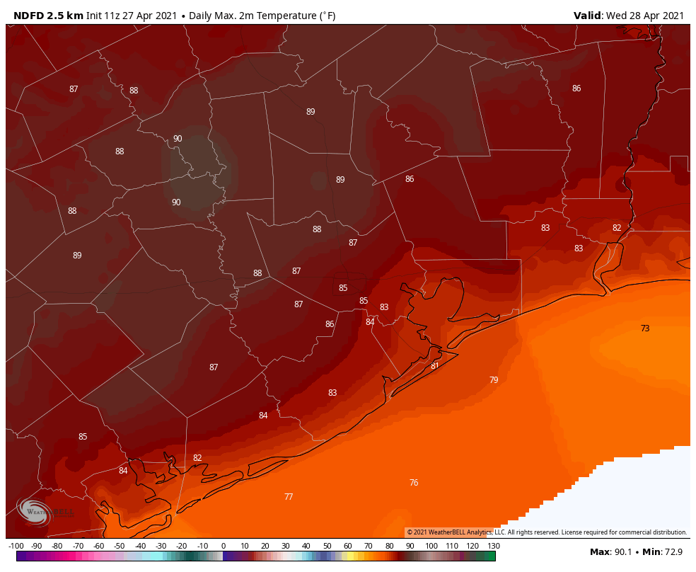
Wednesday
This will be a warm day. Southerly winds will continue to blow on Wednesday, turning a bit gusty, but there should be a few more breaks in the clouds. This sunshine will goose temperatures, and I think parts of the region will likely see highs in the mid- to upper-80s. While we can’t entirely rule out a few showers Wednesday night, the better rain chances will come on Thursday.
Thursday
The region’s next front will approach Houston on Thursday. This will bring an increased rain chances, but there’s not a whole lot of consensus in the model forecasts. There are some hints that we may see pockets of heavy rainfall, but most of the systems we’ve seen this spring have significantly underperformed in terms of rainfall. So my expectation is for a few tenths of an inch of rain with this front, but it’s something we’ll need to watch. High temperatures will likely get to about 80 degrees, with mostly cloudy skies to go along with our rainfall. As for the front, it will likely slog toward the coast, pushing offshore overnight.
Friday, Saturday, and Sunday
I’d love to tell you that we’ve got a great handle on the forecast for this weekend, but that would mean I’d be lying to you. The reality is that some of the guidance, including the European model, have backed off on the amount of dry air coming in with Thursday night’s front. For now, my best guess for Friday through Sunday is highs of around 80 degrees, lows in the 60s, with partly sunny skies and a modicum of drier air. By Monday we’ll probably be on a significant warming trend, likely headed back toward the upper 80s.
Hoping for a good forecast for Saturday for the MS 150 ride. Can you give us cool and dry and a gentle south tail wind? Please?
Glad to hear the app is ,moving ahead.
Looking forward to the app glad it’s coming soon.
I’m going to have to get that app when you’ve got the iPhone version ready!
So excited for the App! You all are the most accurate in Houston. Congratulations on continuing success.
Hard to trust an app when they can’t spell check or use proper grammar. Look at the title to the story with the improper use of “an”.
Looking forward to the app. Just keep it simple.