After days and days and days of warm weather, with a persistent southerly breeze, our weather will change today and tonight. Most of the region should see scattered showers this morning, with an increasing chance of thunderstorms this afternoon and tonight. It has been a rather dry spring, so this rainfall will be mostly welcome. A front will bring some briefly drier and cooler weather before we warm up again next weekend.
Monday
It’s rather warm this morning, with lows only dropping to around 75 degrees in the city of Houston. Highs today will reach the mid-80s, with mostly cloudy skies and light southerly winds. Light rain is possible this morning. Due to the front’s approach and our extremely moist atmosphere, thunderstorm chances will start to increase this afternoon for areas north of Interstate 10 before sagging southward this evening toward the coast, where conditions will be less supportive of heavy rainfall.
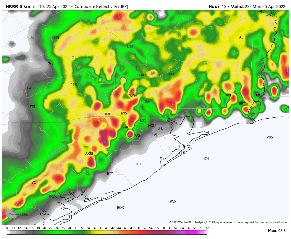
Most of our region will probably get rainfall through the overnight hours, with areas north of Interstate 10 seeing perhaps 1 to 2 inches, and areas south of the freeway recording 0.5 to 1 inches. However there will be wide variability in rainfall totals depending on precisely where storms set up. One location may pick up 4 inches, whereas a few miles away there’s a few tenths of an inch.
Tuesday
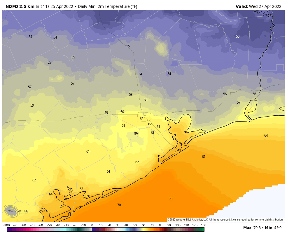
Some rain chances will linger on Tuesday morning, but the threat of heavy rainfall will have passed. However, skies will remain mostly cloudy, and with moderate northerly winds highs probably will only reach the mid-70s. As skies start to clear out overnight, and with the influx of more dry air, lows on Tuesday night heading into Wednesday morning will be the coldest of the week. Expect 50s for inland areas, with mid-60s right along the coast. Don’t blink, because it won’t last long.
Wednesday
This should be an extremely pleasant day, with highs of around 80 degrees, light winds, dry air, and partly to mostly sunny skies. Lows Wednesday night will be a few degrees warmer than Tuesday night as a southerly flow starts to exert its influence.
Thursday and Friday
These should be a pair of partly to mostly sunny days with highs in the 80s, although by Friday highs will probably be pushing into the upper 80s. Southerly winds will start to pick up, at 10 to 15 mph, likely with gusts of about 20 mph.
Saturday and Sunday
The weekend looks warm and humid, with highs ranging from the upper 80s to 90 degrees. Both weekend days should see a mixture of sunshine and clouds. We can’t entirely rule out some scattered showers, but for now I’d put the chances in the 10 percent range. Winds will be noticeable out of the south, perhaps gusting to 20 mph. If you’re riding Bike MS: Texas MS 150 on Saturday and Sunday, those southerly winds should be fairly consistent along your whole route.
Conditions look to remain warm heading into early May, with only a slight chance of a weak front during the first week of next month. I hate to say it, but summer is nigh.
Forget “Winter is coming” as a catchphrase. Time to use Eric’s “Summer is nigh” since it will be here and it will be staying a while.
When will these winds stop though? I don’t ever remember a spring this windy (yes I did see the post last week about windy Aprils).
At least the winds make outdoor work a little more pleasant in the humidity.
yep, there are hints it could be a hot summer – it will be more tolerable if there is a breeze….
The winds should start to die down once the subtropical high sets in sometime in mid to late June. That’s assuming we don’t get an early tropical storm or hurricane
Was rained on twice yesterday on the drive home from the Astros. I’m thinking Pena’s walk-off homer must have knocked something loose in the atmosphere.
Had a good, unexpected, half-hour, steady-rain soaking around 1 am this morning. The plants and trees welcomed it.
It is 12:34 PM in The Woodlands and currently having a lovely downpour. Gotta love Texas weather!
3:40 PM – RAIN!! Ellington Area.
My flight to Houston was diverted to Oklahoma City and we’ve been sitting here for over an hour. No idea when IAH will reopen. Thought that it wasn’t supposed to rain much until tonight. Arrggghhhh!
Started raining here in Sienna at about 3:40. 1″ in 20 minutes. Peak rate was 4.28″/hour. Another 1″ in next 40 minutes. Another 1″ in next two hours. Total between 3:40 pm and 8:40 pm is about 3.3″. And you were saying moderate drought around here?
To me it seems that the storms are more “ferocious” for lack of a better word over the past few years. Same with the winds. They are noticeably stronger and more frequent in my humble opinion. .