If you missed it, Eric and I have decided to start doing tropical updates for you every week or two through hurricane season. We had our first one last week, which was rather detailed. This week, we’ll be a little more succinct!
Tropical outlook in a sentence
The Atlantic basin continues to be void of much interesting tropical activity, and it will likely continue that way for the next week to 10 days.
Near-term summary
Dust, dust, dust. And shear. Those two things are characterizing the Atlantic basin today. Dust from the Sahara Desert continues to roar across the Atlantic. This tends to be a fairly common feature in the early parts of hurricane season. We’ve noticed it a lot more in recent years, and I’m not sure if that’s because of some functional change or just because our observational capabilities have gotten so much more sophisticated. Either way, the last few years have seen a lot of Saharan dust in the basin in June and July.

From the satellite image above, you can see where dust (yellow/orange/red) is located, as well as cloud cover (gray). Virtually the entire Atlantic basin is littered with Saharan dust right now. This includes the Gulf of Mexico. Some of that thicker dust is likely to appear in Houston’s skies in the days ahead.
Why does this matter? Well, Saharan dust is extremely important globally. It’s a major source of nutrients for phytoplankton, and it helps to fertilize the Amazon. It obviously doesn’t come without problems, as the dust can irritate those who have sensitive respiratory systems, allergies, or asthma. It reduces air quality, and we may well see that here in Houston for late this week.
But from a tropical point of view, Saharan dust can help hinder systems from developing. The dust is indicative of dry air in the atmosphere. Obviously, hurricanes need moist air. Think about our weather here in Houston. On days with a “cap” in the atmosphere, there’s a barrier that exists preventing or limiting how high cloud tops can go. That reduces our thunderstorm chances. The Saharan air layer can act as a “cap” as well, preventing storms from billowing up. It doesn’t entirely prevent tropical storms or hurricanes from developing, but it can severely limit how well developed they can become. So curse the dust when it irritates your sinuses, but thank it for helping to keep the early part of tropical season under wraps.

In addition to Saharan dust, the tropical Atlantic is mostly being smothered with wind shear right now as well.
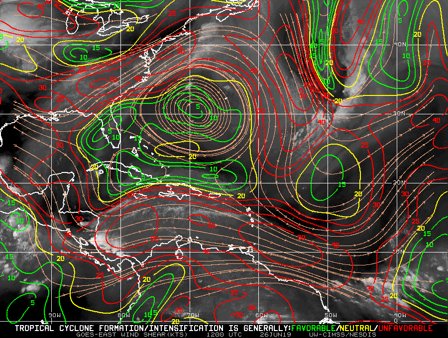
Anywhere you see red on the map above, it indicates high wind shear. Right now, that includes the Gulf, the Caribbean, and most of the tropical Atlantic. Wind shear acts to prevent thunderstorms from organizing and beginning to swirl. It can rip organized storms apart. High wind shear typically means limited tropical activity.
Between the high shear and high quantities of dust in the Atlantic basin right now, it will be tough for anything to organize for at least the next seven to ten days.
Weather model fantasy-land
Looking way out in time, neither the GFS model, the European model, or any of their ensemble members show any meaningful activity in the Atlantic basin over the next 14 days. They do show a bit of an increase in “noise” in the Eastern Pacific, but as of yet, that does not translate into the Atlantic.
Long-term outlook
Most of my thoughts from last week’s post hold today. I do think we will see something develop by mid-July, but I am a bit less confident in that today than I was a week ago. I explained a lot of this in last week’s post, so I’ll just direct you to that to understand more about the MJO and how it can impact tropical activity. At a very high level: The passage of an MJO wave can help “prime” the tropics for increased activity during hurricane season.
What has changed since last week? Perhaps the MJO movement has slowed a bit and also weakened a bit, which is mostly good news if you don’t want to see tropical activity.
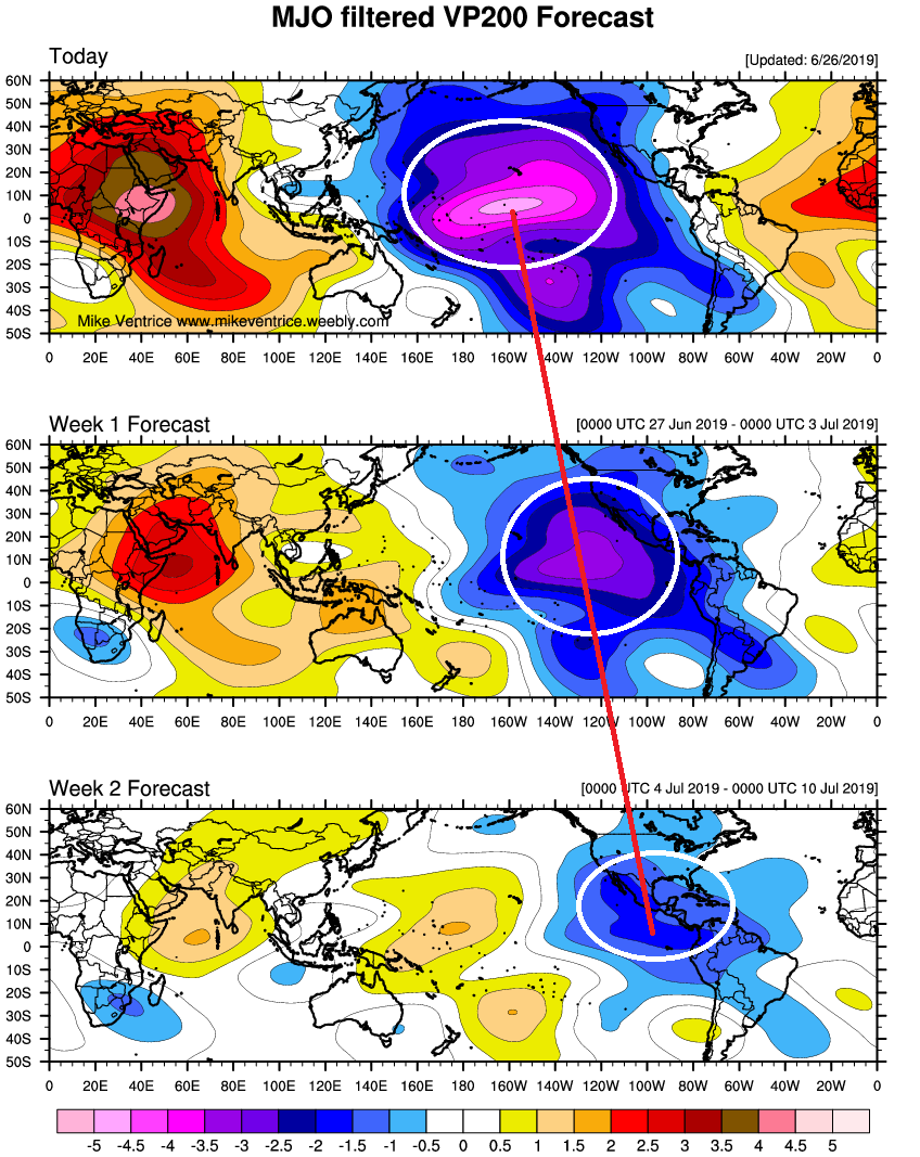
If you notice the plot above, the MJO wave is focused on the Central and Eastern Pacific over the next 7 days. That arrives in Central America, in a weakened state around July 10th. This is running about four or five days slower than when we posted last week. It’s also weaker looking, which could limit how much impact it has on tropical activity in the Atlantic. These are the perils of using one specific variable like the MJO when making a long-range forecast.
So, to summarize the tropical outlook right now: Dust and shear will limit activity in the near-term. We still expect conditions to become more favorable through July, perhaps by mid-July for some activity to increase, but confidence in that is fairly low at this time.
In grand cayman. Dust was heavy for a few days but gone today. Maybe good things for Houston soon.
Matt, has anyone studied the opacity effects of this dust to the Atlantic water temperature?
Reflectivity and transmissivity and other properties of this overhead carpet must have some effect on our seasonal weather.
Enjoying so much your lessons. Although I’m still in panic mode thru hurricane season, I am understanding and receiving answers to many “whys”. Thank u so much!
What about El Nino and its impacts on the Atlantic this summer?
In theory, an El Niño should limit tropical activity, but it’s never a guarantee. I did some math on recent El Niño events and found only a small drop off in the number of storms and hurricanes in those seasons as compared to ones without an El Niño event. But, it certainly doesn’t hurt to have it around.
Good Rundown
What about intensity for those seasons
We are planning a big outdoor bash on the 4th of July. We live north of The Woodlands, in Montgomery. What are the chances for a rain-free day on the 4th?
Patricia – maybe check the normal long term weather sites rather than treating these guys as your personal event weatherpeople and asking them to give you some purely speculative answer?
Seriously, when did this site become the place for people to ask for 10 day predictions as to the weather for their personal outdoor event no one else here cares about?
It would be interesting to analysis it based on the El Nino and other known occurances that we’ve been aware of for a number of years. Could it be that the dust is affected by them, or a by product so to speak.
Good Rundown
Love y’all!
Some weather guys are claiming we are going to see some tropical rains over the 4th. Y’all seem to directly conflict. Am I understanding this right?
The Dust Severely Limited The Visibility At The Space Shuttle’s TAL Sites(Trans Atlantic Abort Sites. It Was Often Below The Required 5 Miles!
I think the definition of “tropical rains” needs to be clarified. What we’re discussing in this post is organized tropical storms or hurricanes. The tropical rains being talked about are what we’d typically see in Houston a few times each summer, where a tropical wave or disturbance (disorganized) brings increased chances of storms for a 1-3 day period or so. I’m guessing that’s what they’re referring to, and right now that may be an issue early next week…hopefully ending by the 4th.
Thank you Matt. You and Eric are my go to. I’m thankful for your work.
The Dust Severely Limited The Visibility At The Space Shuttles TAL Sites(TransAtlanticAbort)…It Was Often Below The Required 5 Miles!
Matt and Eric, thanks for the short course on dust, wind shear and other variables. My question is how is the data obtained for all these wind shear models, especially over large expanses of water.
The simple answer is that satellites are capable of amazing things. We have so much data now and it’s so sophisticated that we have the ability to monitor so many things that 10-20 years ago even were difficult to keep track of. The recent addition of GOES-R and GOES-S (Now GOES-16 and GOES-17) satellites have only enhanced this capability. So we can keep tabs of many things over the oceans, where in the past we used to really rely on first-hand observations that were sparse, sporadic, and not especially reliable.
Very interesting Matt! I like these kind of posts.
Testing a post because a got a message saying I was blocked…