In brief: Today’s post discusses sea fog, of which there is plenty near the coast this morning. Beyond that, the forecast is proceeding pretty much as expected, with much warmer-than-normal weather for February expected through Saturday. Some sort of cold front arrives later on Sunday, probably, to bring somewhat cooler weather.
Sea fog
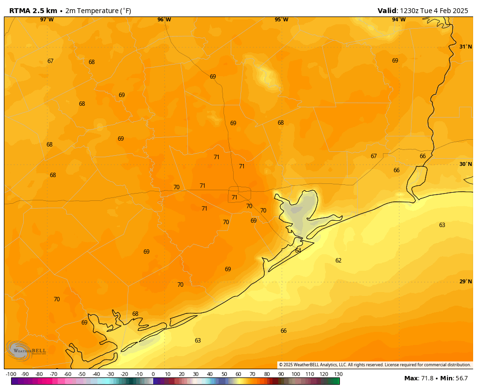
The closer you live to the coast, the greater the chance you’re experiencing sea fog this morning. This is caused by warmer air—such as we’re experiencing now, with air temperatures of about 70 degrees near the coast—moving over somewhat cooler nearshore waters in the Gulf. This fog forms when warmer air moves over the cooler waters, and the air temperature falls to the dew point temperature, saturating the air.
Note that air temperatures this morning are cooler right along the coast and just offshore, a key indicator that sea fog is possible. (Weather Bell)
A dense fog advisory is in effect until 9 am this morning, with visibility is some locations low as one-quarter of a mile. If you’re driving in this, please leave a little more space between vehicles, and use your low-beam lights. With warmer weather this week, fog will be possible in coastal areas through Friday or possibly even Saturday morning.
Tuesday
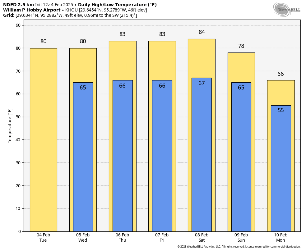
As noted in Monday’s forecast, the weather this week will vary little from day to day. We’ll see a persistent onshore flow all week, and this will lead to a warm and consistent pattern. High temperatures today will reach about 80 degrees, with partly sunny skies. Winds will be from the south at 5 to 10 mph. With dewpoints in the 60s, the air will feel somewhat sticky. Lows tonight will only fall into the upper 60s for most of the metro area.
Wednesday, Thursday, and Friday
Rinse and repeat. Expect warm days in the vicinity of 80 degrees, with partly to mostly sunny days, and mostly cloudy and warm nights. We can’t entirely rule out rain chances, but they’re quite low, perhaps on the order of 10 percent each day.
Expect a warm week ahead for Houston. (Weather Bell)
Saturday and Sunday
The first half of the weekend brings more of the same, however it now appears likely that some sort of front will push into the metro area on Sunday. The timing and strength are still to be determined, as well as the likelihood of rain with the front. At this point I’ll predict high temperatures in the low-80s on Saturday, a warm night, and highs near 80 degrees on Sunday with a modest chance of rain. Lows on Sunday night will fall into the 50s. All of this is in pencil, mind you.
Next week
With uncertainty about the strength of the front, and possibly a secondary push of cooler air mid-week, I don’t feel too confident about what to expect next week, except to say that it probably will feel more like February than this week does. I also think we’ll see more clouds and better rain chances. But as ever, the long-range details are fuzzy.
In brief: The forecast for this week is pretty boring, and unchanging. In fact, I give you permission not to check Space City Weather for a few days. We are going to be rather warm for February this week, with low rain chances. So this post addresses the question, is winter over?
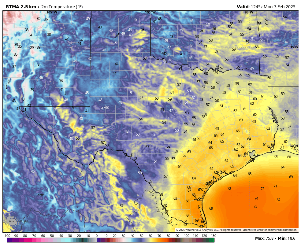
The eastern half of Texas is already seeing mild weather this morning. (Weather Bell)
Winter update
Sunday was gorgeous, and it felt much more like spring than winter. And the truth is, the entirety of the coming week is going to be quite warm with daytime temperatures around 80 degrees and mild nights in the 60s. So it is natural to ask, is that it for winter this year in Houston?
That depends. As the calendar goes, winter in Houston lasts from December through February. So we’ve got a few more weeks to go. Based upon the questionable prognostications from Punxsutawney Phil, who saw his shadow during a ceremony on Sunday, we have six more weeks of winter. But what does the science of meteorology say?
As usual, we have few absolute answers. However, it does seem clear that Houston’s pattern will turn colder next week. Moreover, there is the potential for another significant outbreak of colder air during the second half of February. This is because our latest data indicates that the stratospheric polar vortex, which bottles cold air near the north pole, may split and allow some of this very cold air to come down into the mid-latitudes. The timing for this would be later in February, or early March.
So our advice is that, yes, this week is going to feel unseasonably warm for February. It’s definitely shorts-and-t-shirts weather. But don’t put away those sweaters just yet.
Monday
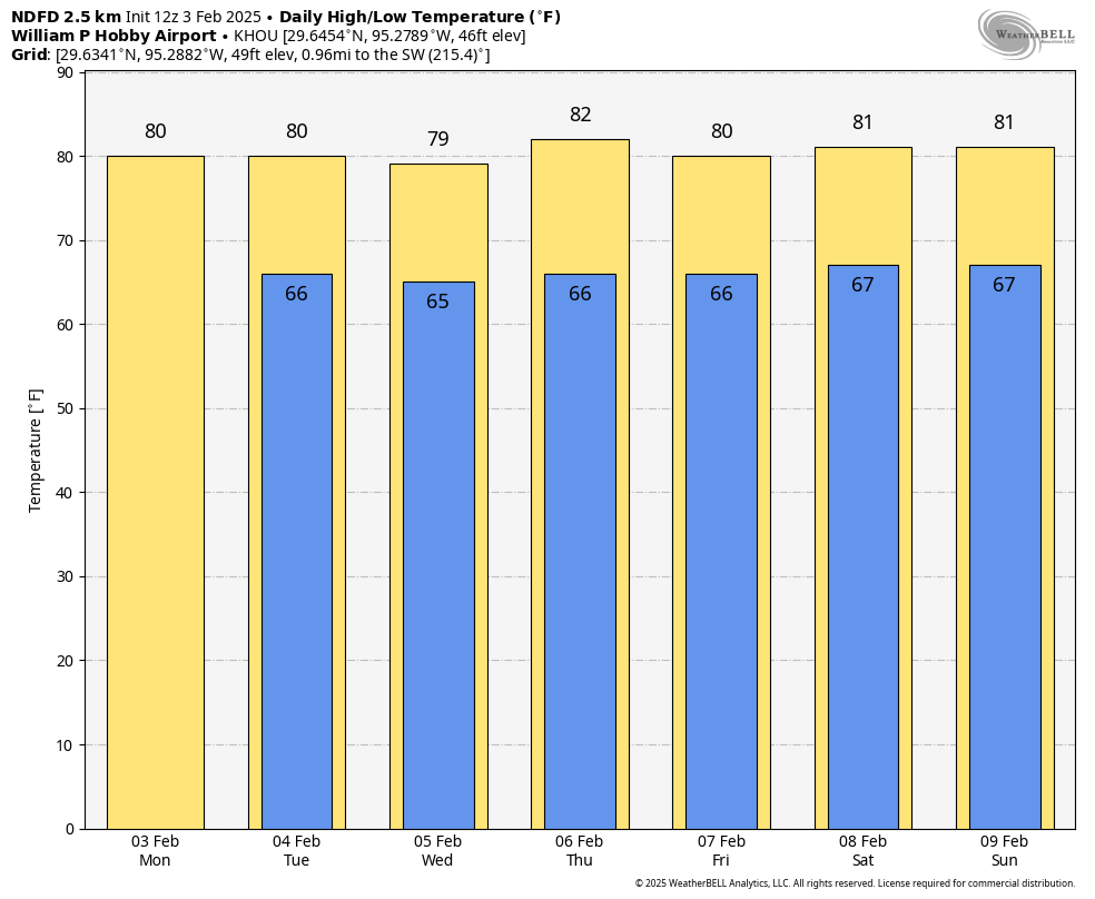
Temperatures in Houston this morning are generally in the lower 60s, and this is as cold as our weather is going to get until next Sunday or Monday. This pattern is due to a persistent onshore flow, and it’s not going to vary much this week. This kind of warmer weather at this time of year is supportive of sea fog, so there will be a chance of that most mornings this week. Highs today will reach about 80 degrees, with partly sunny skies. Lows tonight will drop into the mid-60s.
That is a consistent forecast for this week. (Weather Bell)
Tuesday through Friday
Not much changes for the rest of the week. Expect partly sunny days, with highs of around 80 degrees, and cloudy nights in the 60s. There is perhaps a 10 percent chance of rain each day. Winds will be from the south each day at about 10 mph. With dewpoints in the 60s, it will feel moderately humid. And that’s basically the forecast. I should take a holiday.
Saturday and Sunday
The weekend looks more or less the same, with highs of around 80 degrees, lows in the upper 60s, and a mixture of clouds and sunshine. Southerly winds may pick up a little bit on Saturday from the south. At some point a front is going to come trundling through, but it’s not clear to me whether that will happen on Sunday, Monday, or Tuesday.
Conditions should turn more seasonal across Texas next week. (Weather Bell)
Next week
Whenever said front arrives it will probably bring our first meaningful rain chances with it. The front will also usher in winter-like conditions back to Houston, probably driving low temperatures down into the 40s during the second half of next week. But the timing and intensity of such a cold snap remains pretty fuzzy, as we’re talking about a period 7 to 10 days from now.
By the skin of our teeth, we’ve got the January SCW Q&A out the door. Many of the questions we got this month were – no surprise – inspired by our recent snowstorm.
Got a question of your own? Hit the Contact link in the blog’s header, or leave it in the comments below.
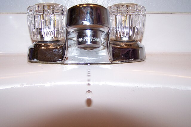
Q. The city asks people not to let faucets drip because it lowers water pressure. I understand there are ways to keep pipes warm, but how much does a dripping faucet actually help prevent pipes from bursting anyway? I’d rather have lower water pressure than broken pipes but wonder if letting faucets drip even helps much.
A. We get asked this question so often, and our standard response is: We are not plumbers. We are just not experts in this area. So we can offer some general thoughts, but you should really consult a plumber, and your water utility.
My best advice, as a homeowner in Houston, is to know where the main water shut-off switch is to your house, and if you’re concerned about freezing pipes, shut off the water supply and drain your pipes (i.e. run faucets until nothing comes out) before going to bed on nights when the temperature is expected to be below 25 degrees.
To drip or not to drip: That is the question. (Angelsharum / Wikimedia Commons)
As for dripping faucets, cities do not like that because it is not great for pump-based water systems. If too many people do it, it can reduce overall water pressure. If that gets too low, contaminants can get into the water supply, which can then result in a boil-water notice – and nobody wants that.
In unincorporated Harris County and those areas served by Municipal Utility Districts, it’s OK to drip pipes because water pressure there is generated by gravity – water towers and tanks – not pumps. During a freeze, your water utility will let you know what’s best.
So while homeowners may find comfort in dripping faucets, and many plumbers recommend it, be aware of what your utility is saying.
As my wife will attest, I am just about the least handy person on the face of the Earth when it comes to home maintenance.
– Eric
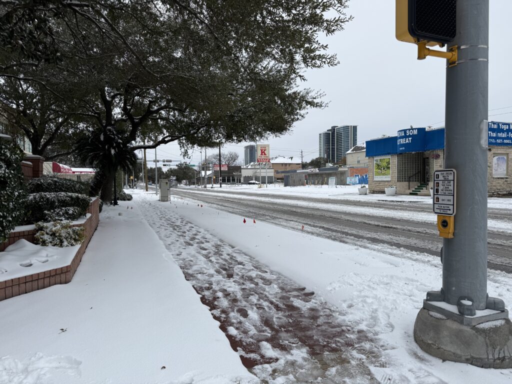
Q. Was it (January’s snow) really a “storm”? Traditionally, a storm is a violent event, typically bringing high winds, heavy precipitation, lightning, thunder, and other various tumults. While this event was unusual by Texas standards, it would barely have attracted notice in more northern locales. So my philosophically pedantic question is, does just being ‘unusual’ justify the use of the ‘storm’ moniker?
A. Ah yes, this is the kind of question we battle a lot in meteorology. Is it hot or warm? Cold or cool? A storm or just rain? And it gets to the heart of a more important question my colleague and friend Nick Lilja has asked, which is “What is severe weather, really?” Everyone has their own perceptions and definitions and to one-size-fits-all it is difficult.
But to the original question: The American Meteorological Society defines “storm” as a “disturbed state of Earth’s atmosphere, which can manifest itself in temperature, humidity, pressure, wind velocity, cloud cover, lightning, and precipitation.” Which seems to imply it’s OK to call our recent snow a “storm.” That is a really, really broad definition though. The AMS goes on to further define things. “Storms are organized disturbances that range in size from meters to a few kilometers (microscale, e.g., tornadoes), to a few to several hundred kilometers (mesoscale, e.g., mesoscale convective systems), to many hundreds of kilometers (synoptic, e.g., tropical and extratropical cyclones).” That still tracks with last week. So far so good.
Yep, looks like a storm to us. (Dwight Silverman photo)
The definition further goes on to read “Inclement and potentially destructive weather is often implied with a storm; threats can include heavy precipitation, flash flooding/river flooding, and high winds. From a local and special-interest viewpoint, a storm is a transient occurrence identified by its most destructive or spectacular aspect(s). In this manner we speak of rainstorms, windstorms, hailstorms, snowstorms, etc. Notable special cases are blizzards, ice storms, sandstorms, and dust storms.”
So from a meteorological and scientific point of view, last week’s snow was definitely a “storm.” Or more specifically a “winter storm.” But your mileage may vary. You may think a thunderstorm with frequent, intense lightning is very severe. By definition, lightning has nothing to do with a “severe thunderstorm,” which is strictly defined as a storm that produces one of one inch or larger hail, wind of 58 mph or stronger, or a tornado. Like any other definition in meteorology, there is a little vagueness to it from a human standpoint, and you’re not always wrong for thinking something is or isn’t a particular defined phenomenon.
– Matt
Q. When you say south of I-10, do you mean Galveston? Or does that mean anywhere directly below I-10 (Montrose, Downtown, Medical Center, etc).
A. Great question, and it’s one we get often. One of the challenges of forecasting in the Houston area is that it is big! We are covering, basically, an area from Sealy in the west to Beaumont in the east, from Conroe in the north down to Galveston by the Gulf. Interstate 10 is a key dividing line we often refer to because a) most people know where it is, and b) it very roughly separates “coastal” from “inland” areas.
The Houston area is big. How big? This big! (Apple Maps screenshot)
However, with that said, there are distinct differences between, say, Hobby Airport and Galveston Island. So yes, “south of Interstate 10” does include Galveston, but it also includes half of this huge metro area. When we want to call out the coast specifically we’ll say “coastal counties” i.e. Brazoria, Galveston, and Chambers counties. When we seek to highlight only areas very near the Gulf, which includes Galveston Island, we’ll sometimes say “immediate coast.”
By the same token, when we write something like “far inland areas” we mean areas along and north of Highway 105. And when we write “a place that sucks” we’re referring to Dallas.
– Eric
Q. Could you explain why there are so many variations among weather apps? For example, the AccuWeather app shows (last) Tuesday being having a high of 38 while almost all the TV weather is showing Tuesday not going above freezing. If all meteorologists pull from the same info why such a wide difference in the forecasts?
A. There are a couple reasons for this. I’ve been doing this 20 years, and one thing I’ve said is tried and true: Put 20 meteorologists in the same room with the same data, and you will get 20 different forecasts. And I don’t mean widely varying forecasts; just a lot of differences in specifics.
But there are a couple areas where broadcasters, apps, and even the data we see on websites differs. Let’s say the high temperature occurs at midnight because a cold front is pushing through, but the daytime temperature is going to be 10 degrees colder. What’s the high temperature that day? What matters to you planning your day? Broadcasters, sites like ours, and the NWS website will all illustrate this either explaining it or by using arrows to indicate that something is changing that day. Your app almost certainly will not.
The Space City Weather app, as seen on a Mac.
But more important than that, every app uses its own special sauce. In other words, they are all deriving their forecasts from raw model data provided by NOAA, the European Centre (ECMWF), etc. They then work it through some proprietary algorithm that they’ve developed that essentially “bias corrects” the model data. They could be using the last week of verification, the last month, etc. Every app is different in that regard. I saw a presentation recently at the American Meteorological Society’s annual meeting in New Orleans from someone at AccuWeather that discussed this topic. One difference in their forecast is that their forecasters can actually go in and override data for a location or area if they have a strong conviction to disagree. Most apps do not come with that. I would assume The Weather Channel app does something similar.
So ultimately, each forecaster has their own opinion. For the apps, most of the “opinion” is bias correction of data, whereas for TV broadcasts or our comments, the opinion is based on our assessing the data and our past experiences. There will always be differences, but one reason I like our app is that it’s pulling forecasts straight from the National Weather Service. Their forecasts are usually solid and steady, and they’re derived locally. But as a consumer, I would always encourage you to shop around to get a sense of what everyone is thinking.
– Matt
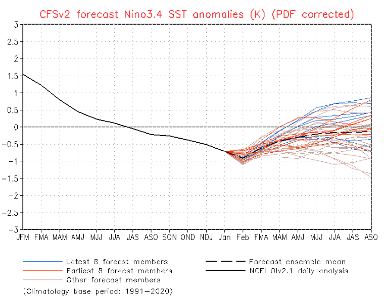
Q. I have a question- where did La Niña (warm and dry) go? Where do you think we’ll be Spring and Summer of 2025 – La Niña, El Niño or neutral?
A. According to NOAA’s most recent outlook, from late January, La Niña conditions are still present in the equatorial Pacific Ocean. Most modeling indicates that La Niña will persist through the spring before transitioning to neutral conditions. As for what happens after that, well, it’s kind of a crapshoot. Most of the guidance indicates neutral conditions lasting into the summer (and the Atlantic hurricane season). However, as we like to say here on Space City Weather, we’ll see.
Most recent forecast for ENSO. (NOAA)
I think you may be asking why have we not had a warmer and drier winter, which is typical during La Niña? To which I would say let’s see where the average temperature and rainfall end up at the end of February. I think it’s quite possible we end this winter with warmer than normal temperatures and near normal precipitation, which would be consistent with what one expects from La Niña. We’ll be sure to report back on that at the end of winter about a month from now.
In brief: The weather over the next 3 or 4 days looks stellar, seasonably mild, and quiet in Houston. Outdoor activities will be just fine. The return of dreary, possibly foggy weather awaits us after Monday. Our next front is penciled in for next weekend.
Yesterday’s rainfall did little to the region, with most areas seeing under a quarter-inch. A narrow corridor from Bellaire through the Timbergrove saw between a quarter and half-inch, as did the area from Alvin through Baytown and Mont Belvieu. The real heavy stuff fell from portions of Hill Country (which is good because they need it) all the way through Dallas and to just west of Texarkana. As much as 4 to 5 inches of rain fell between Dallas and the Red River.
Now, we move on to blue skies and a top 5 weekend of the year.
Today through Sunday
It may take a minute to clear out all the clouds today, especially southeast of Houston. But in general, all three days should be mostly sunny. Really, just near perfect weather. Look for highs in the 60s today with a bit of a breeze, near 70 tomorrow, and into the mid-70s on Sunday. Humidity should stay low. Morning lows should be generally in the 40s tomorrow and Sunday.
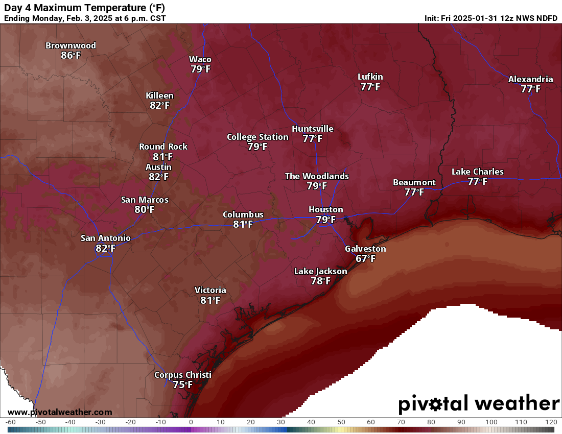
By Monday we have a shot to begin hitting 80 degrees away from the coast. (Pivotal Weather)
Monday
We’ll start next week in transition as onshore flow becomes firmly established in the area, bringing in Gulf moisture, driving up our humidity, and ensuring we see cloud cover. Monday will be in flux, so still look for sunshine, but some possible areas of fog could crop up near the coast through the day. Depending on how much sun we see, we could test 80 degrees Monday afternoon after lows in the 50s.
Tuesday and Wednesday
These will most likely be gray days in the Houston area, especially for the first half of the day.
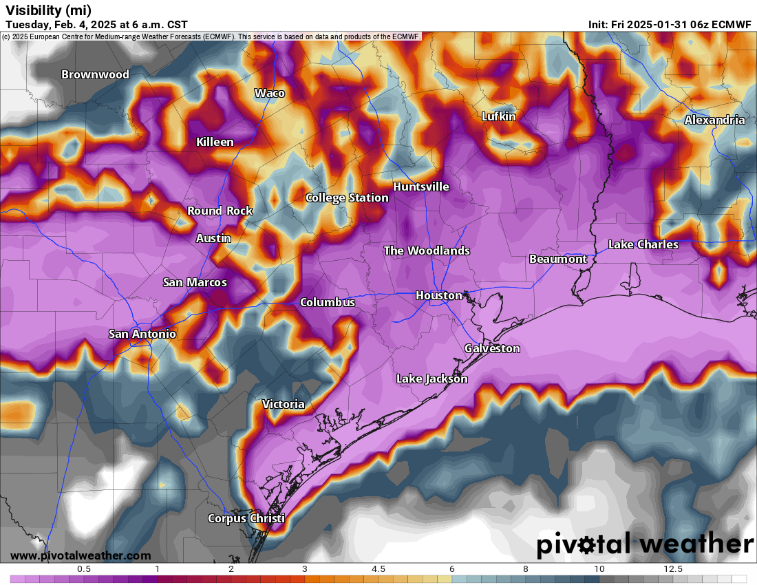
The potential for widespread low clouds and fog (purple) is rather high next Tuesday and Wednesday. (ECMWF model via Pivotal Weather)
With warm and humid air crossing the cooler nearshore waters of the Gulf, that’s a good recipe for low clouds and fog. How widespread it is and how long it sticks around each day is still uncertain, but I would anticipate morning low clouds and fog giving way to some breaks of afternoon sunshine. Areas near the coast may stay fogged in all day. We’ll likely see highs in the 70s and lows in the 60s, but we could push or pass 80 degrees with enough clearing each afternoon.
Next front?
It’s still a bit early to speculate, but it does look like our next front could come with a decent push of colder air. Not a freeze by any means but perhaps cooler than we’ll have seen since early this week. The timing is likely to be roughly next Saturday, give or take 12 to 24 hours. This front should come with at least a few showers and thunderstorms, but I wouldn’t set my expectations too high at this point.