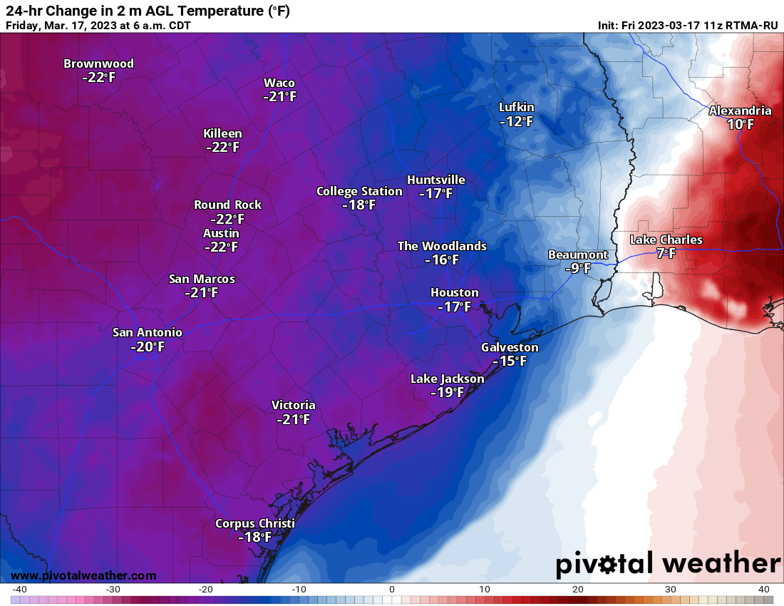
Happy St. Patrick’s Day to those who celebrate. Just a little different out there this morning! Temperatures versus 24 hours are much colder.
Temperatures are running a good 15 to 20 degrees colder than 24 hours ago across the area. (Pivotal Weather)
We are running 15 to 20 degrees cooler than yesterday, and that disparity will probably worsen through the day as temperatures stagnate. It feels more like a Valentine’s Day than a St. Patrick’s Day.
Today
Last night’s line of storms is now long gone, but we are left with showers that will actually tick up in intensity some in the Houston area over the next hour or two.
Periods of showers and rain will continue this morning, tapering off this afternoon. (RadarScope)
Look for rain or showers to continue through probably midday across much of the area, and even then it will only gradually shut off. Temperatures will go almost nowhere today, stuck in the 40s, maybe up to low-50s in a few spots later this afternoon. The wind will continue howling at times as well through the day.
Tonight
Cody Johnson takes the stage tonight at the Houston Livestock Show & Rodeo, and you’ll want to dress warmly! Temperatures will be near 50 degrees on your way in and in the upper 40s on your way out with a continued breeze. Rain should be done with, but it will still be a bit damp.
Low temperatures tonight will bottom out generally in the 40s area-wide. Some light rain showers are possible toward morning.
Saturday & Sunday
Look for another cloud-dominant day tomorrow. Temperatures will probably again struggle into the mid-50s at best. A few passing showers will be around, especially south of Houston. It’s entirely possible that a few areas see some sleet mix in with the rain, though I’m not sure it will be precipitating hard enough for that to happen. For those of you planning outdoor activities, there’s probably a better chance than not that you’ll be mainly dry this weekend, but it will remain breezy and chilly and mostly cloudy.
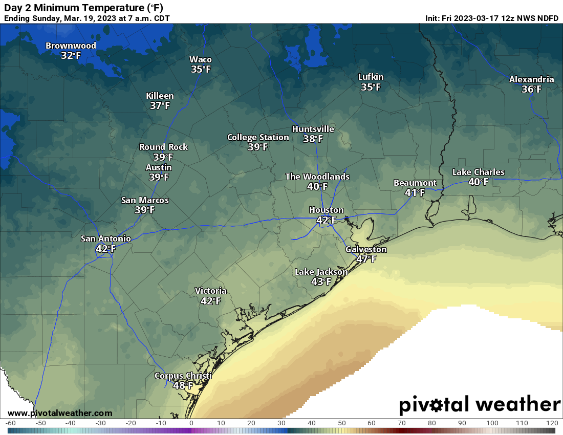
Sunday morning low temperatures will be quite chilly on Sunday, with 30s in outlying areas and around 40 closer to Houston. (Pivotal Weather)
Morning lows will be chilly on Sunday. We expect 30s and 40s for minimums. A freeze is not a concern in the Houston area, but it’ll certainly feel cold. Look for another day of mostly cloudy skies and low-end shower chances on Sunday, with highs perhaps a little better into the mid or even upper-50s. Either way, be ready for a chilly finale to the Rodeo!
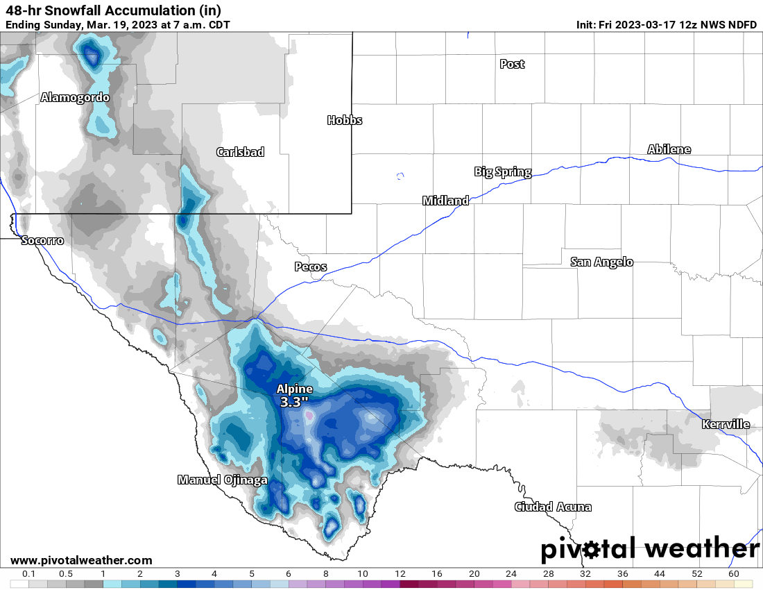
A quick note: If your travels are to or from Big Bend or Guadalupe Mountains National Park this weekend, there is a good chance of some snow out that way. Higher elevations of West Texas may see an inch or two of snowfall from this moisture and cold.
A few inches of wet snow are likely in higher elevations of West Texas this weekend, including portions of Big Bend National Park. (Pivotal Weather)
More a curiosity than a travel woe, but certainly impressive for mid-March!
Monday and Tuesday
Look for another day of mid or upper-50s after morning lows in the 30s and 40s on Monday. Monday morning may be the coldest of this stretch with widespread mid to upper-30s. Tuesday will see 40s to low-50s in the morning and upper-60s in the afternoon. Both days will be partly sunny with a low-end chance of showers.
Later next week
We will certainly warm up a lot on Wednesday and Thursday. Look for mid to upper-70s on Wednesday and 80s on Thursday. Both days should see at least some sunshine.
Thursday will feel more like later spring with highs likely into the 80s across the area. (Pivotal Weather)
Beyond that, we may see another cold front around next Friday or Saturday to offer some comfortable weather next weekend and early on the week of the 27th. More on that next week.
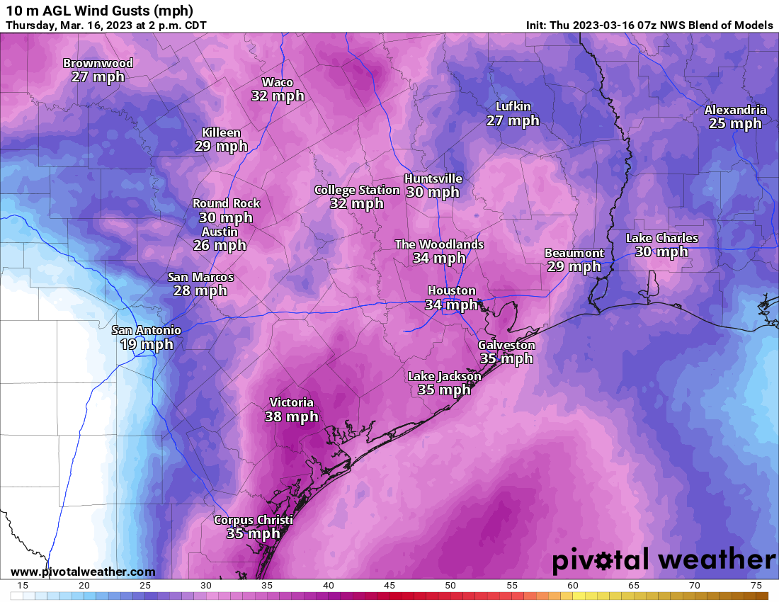
Yesterday was a big swing and a miss for many. Ultimately it ended up being a lovely late day, but the morning smoke that took a bit longer to disperse than hoped really added a sour taste to yesterday’s weather. The good news is that the air quality this morning is great. No issues at all in the area. We do have some weather coming later today in parts of the area, however. And given the wind forecast, you may want to bring in any loose objects that have ended up outdoors during spring break week.
This morning
For most of us, the early morning should be fine. Some showers have begun breaking out north and west of College Station, and they will move east over the next couple hours though. An isolated heavier downpour is possible. Outside of that, watch for the wind to begin gradually picking up as well. In fact, wind may be the most notable story today for everyone, with frequent 25 to 35 mph gusts.
Forecast wind gusts for later this afternoon from the National Blend of Models show much of the area will experience 25-35 mph gusts today. (Pivotal Weather)
Winds will remain gusty into the afternoon and tonight.
This afternoon
Once that little wave of showers moves through, we’ll begin to setup the chances for some strong to severe storms. The primary risk today will be north of I-10, possibly well north of there, where capping is the weakest. Recall, capping usually means that the atmosphere is able to suppress the growth of thunderstorms a bit. South of I-10, capping is likely to remain fairly strong deep into the afternoon, limiting severe risk. Ultimately, it may be areas along and north of Highway 105 that have the best chance for some severe thunderstorms later today.
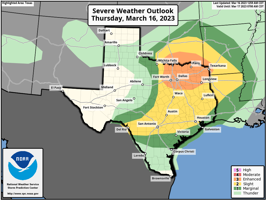
A slight risk (2/5) of severe storms is forecast for most of the Houston area and points north, with lower risk south and higher risk up toward the DFW Metroplex today. (NOAA)
The Storm Prediction Center has us in a slight risk (level 2/5) for most of the Houston area and a marginal risk (1/5) along the coast. If any storms can develop, strong winds, hail, or an isolated tornado will be possible. Again, in the immediate Houston area, this seems unlikely, but the chance is enough to make sure you pay attention today. You’ll certainly want to watch north of The Woodlands, where the risk increases.
Outside any severe weather, there will continue to be a few showers or pockets of light rain. Warm temperatures though, with highs pushing 80 south and west of Houston. And yes, continued windy.
Tonight
Things may actually break this evening for a time. Honestly, if you’re headed to the Houston Livestock Show & Rodeo for Chris Stapleton tonight, you may be fine. Again, keep tabs on the situation and heed any weather alerts from Rodeo officials in the unlikely event they materialize. Look for 70s on your way in — and out.
The next phase of weather will be the cold front itself. The good news is that the timing is likely to occur while most of the area is asleep. That may also be bad news if you have a pet or child that wakes up during thunderstorms. You’ve been warned.
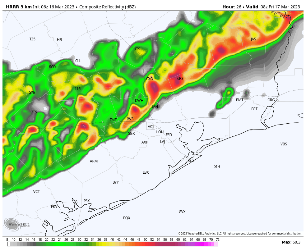
This is a forecast radar image from the HRRR model for 3 AM Friday. While there will likely be some differences in reality, a line of storms should push through around then. (Weather Bell)
The front itself will arrive around midnight in the Brazos Valley, 1-3 AM in the northwest Houston/Montgomery County area, 2-4 AM in Houston and the immediate southeast, and 3-5 AM at the coast. With it? A line of showers and gusty thunderstorms seems likely. Locally heavy rain will also be possible. The real nasty weather should only last 30-45 minutes or less, but the rain showers will linger well into Friday morning. While severe weather is not necessarily expected with this squall line, there is the chance for a couple warnings due to strong wind gusts. Outside of storms even, strong, non-severe wind gusts will persist tonight.
Friday
The front will be offshore Friday morning, and it’s going to feel a heck of a lot different than Thursday. Temperatures will plunge behind the front into the upper-40s or low-50s and only rise a little bit through the day Friday. Wind gusts will probably peak on Friday morning and then slowly drop off Friday afternoon and evening. But it will feel quite raw.
Forecast rainfall from the National Blend of Models shows around a quarter to three-quarters of an inch of rain on average through Friday night, with higher amounts possible, especially north of Houston. (Pivotal Weather)
In terms of weather, rain is likely to continue at varying intensity (light to moderate) through the morning hours, possibly diminishing from west to east by early afternoon. Overall, tomorrow looks like an indoors type day if you have any spring break plans.
Saturday through Monday
The weather looks to be some version of the same thing on both weekend days and Monday. Both Saturday and Sunday look to be mostly cloudy, cool, and breezy. Expect lows in the 40s, highs in the 50s, and at least a slight chance of some pockets of light rain as some weak disturbances pass through in the upper atmosphere. I mentioned ice pellets as a possibility yesterday, and while unlikely, I will not be shocked if someone reports brief, light sleet on Saturday or Sunday, especially west of Houston.
Monday’s forecast is a little trickier as models are shifting around on potential impacts from one more disturbance passing by. We’ll call it pretty similar to Saturday and Sunday with highs in the 50s and morning lows in the 40s, but we’ll have more on that tomorrow.
Tuesday and beyond
The specific weather forecast gets a little more uncertain beyond Monday. What we do know: Temperatures will warm up. But whether that comes with sunshine or more clouds and rain chances is TBD. Look for highs in the 60s on Tuesday, well into the 70s on Wednesday, and perhaps 80s again by Thursday.
Today was supposed to be just a stunning day. Ultimately, it will be, but thanks to some controlled burns in southwest Louisiana it’s starting off poorly. I didn’t intend to start with a science lesson this morning, but here we are.
Why is the air quality bad this morning?
In a nutshell: There’s smoke trapped near the ground leading to poor air quality. It will improve later this morning. If you want the rest of the forecast, scroll down. If you want to understand why there’s smoke this morning, read on.
Air quality this morning is abysmal, in the unhealthy for sensitive groups or even a bit worse.
Air quality (PM 2.5) this morning (as of 6:30) is unhealthy across most of the Houston area away from the coast. (Purple Air)
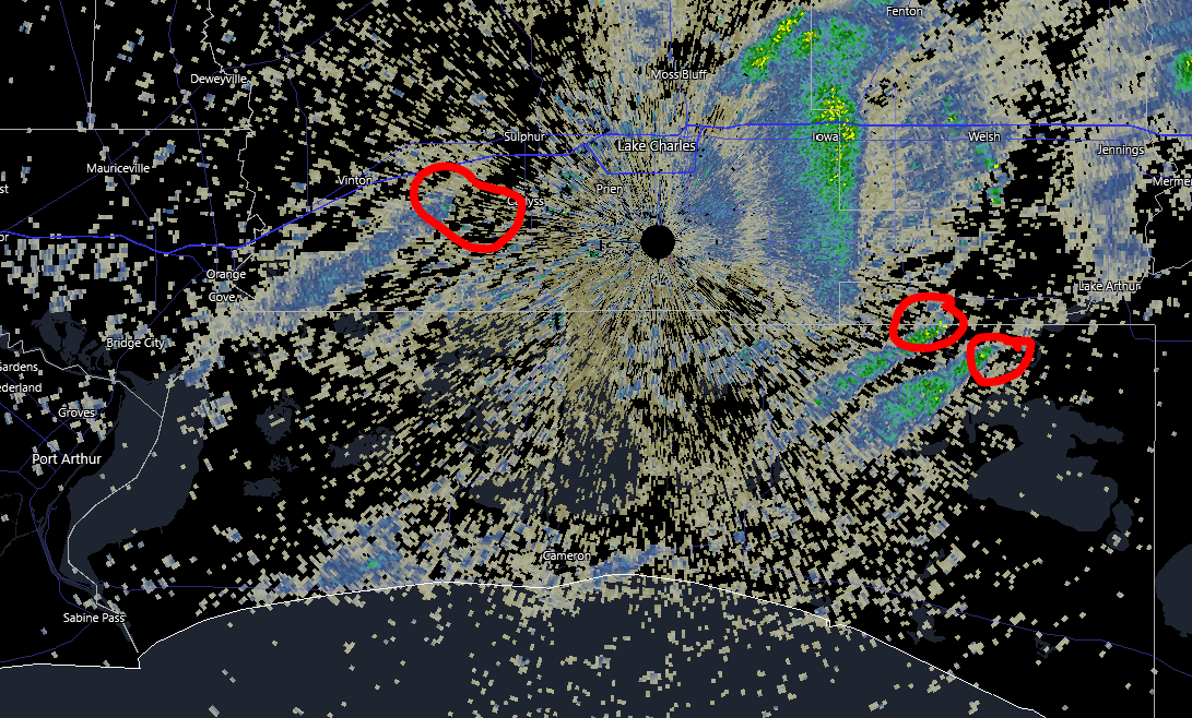
Why? Yesterday afternoon, there were several controlled burns noted on radar in southwest Louisiana.
Radar from about 1:30 PM on Tuesday showed at least 3 fires underway on either side of Lake Charles, presumably controlled burns. (RadarScope)
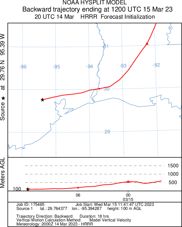
Because our low-level winds are coming from the east and we have an inversion in place (more on that below), that smoke cannot escape into the upper atmosphere and disperse, so it stays at ground level. I ran a backwards trajectory model (called HYSPLIT) starting at 3 PM on Tuesday and ending at 7 AM this morning. In simple terms: I wanted to see where the air we have now came from yesterday afternoon. On the map below, Houston is the black star and the red line indicates where the air came from. The plot below shows how high up in the atmosphere it came from. You can see that the air down near the surface this morning originated from northeast Louisiana, descending to only a few hundred feet above ground level in southwest Louisiana and ending up over Houston this morning.
This morning’s air came from Louisiana, likely picking up lingering smoke from yesterday’s controlled burns and depositing it over Houston this morning. (NOAA)
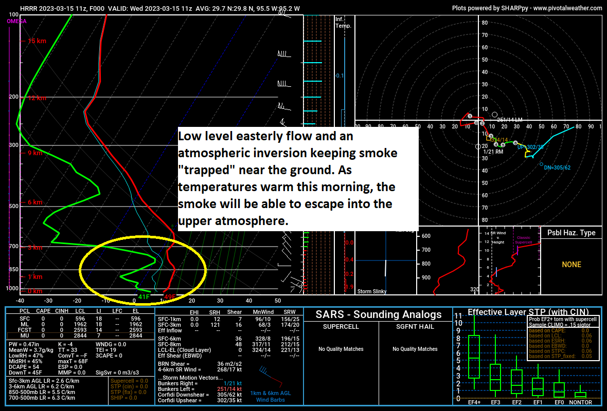
All that smoke is “trapped” under an atmospheric inversion. Normally, you hear us talking about a “capping inversion,” or just cap during days where severe weather is possible. The “cap” basically puts a lid on how tall clouds can grow. It’s the same concept here, except the inversion is close to ground level. In other words, what ends up near the surface stays near the surface instead of being able to escape into the higher atmosphere.
An inversion is trapping the smoke near the surface. As temperatures warm, the inversion will weaken, allowing the smoke to dissipate. (Pivotal Weather)
As temperatures warm up after sunrise, that inversion will dissipate, and the smoke will dissipate with it, leading to a much nicer setup by late morning.
Today (rest of the forecast)
Sunny. Once the smoke clears, it’ll be great. Low-70s. Modest, relatively low humidity for Houston. Tough to argue that. If you want something to complain about today besides smoke, look to the wind. Gusts of 20 to 25 mph will be possible, especially along the coast, so that may annoy some people. Tough to argue that also.
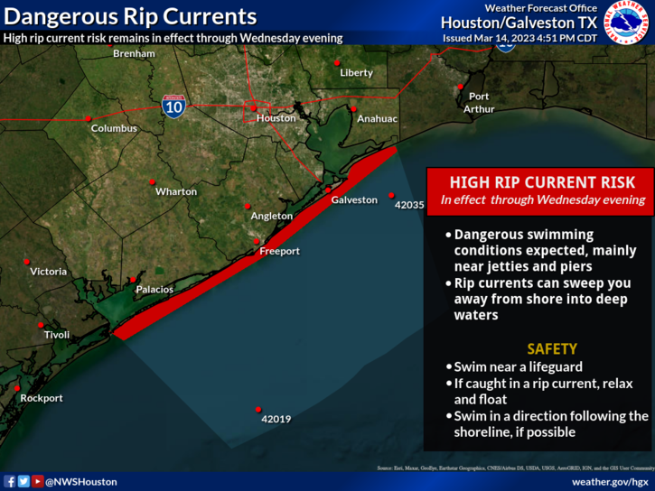
One thing I want to briefly highlight today in concert with our friends at the NWS Houston office are rip currents. Many of you may be in Galveston or other coastal locales for spring break. Please, please use caution if you head into the water.
There will be a high rip current risk on Wednesday, as well as possibly Thursday on the Gulf Coast. Please use caution while swimming. (NWS Houston)
Rip currents can catch even the most experienced swimmers off-guard, so please emphasize safety over the next couple days.
Meanwhile, at the Houston Livestock Show & Rodeo, you’re in luck. Again. If you’ll be heading to see Kenny Chesney tonight, you can expect around 70 degrees on your way in, with temperatures only falling a bit during the show. Look for no worse than mid-60s on your way home. That breeze will continue a bit as well.
Thursday
Tomorrow poses some forecast challenges. The morning looks fine. We’ll have a good bit of cloud cover around, but no real issues are expected. Temperatures will probably bottom out before sunrise, warming through the 60s and into the 70s by mid-morning. During the afternoon, we’ll likely be in a favorable spot for showers and thunderstorms to develop well out ahead of Friday’s cold front.
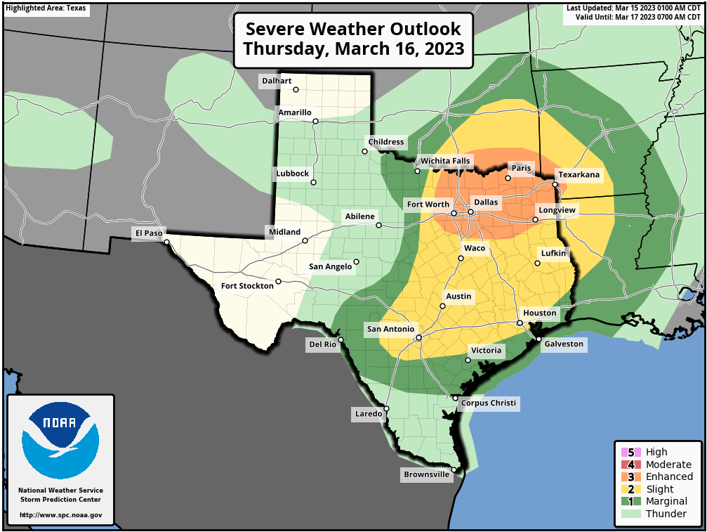
Houston is in a slight risk (level 2/5) for severe weather tomorrow, with the Dallas-Fort Worth Metroplex at higher risk. (NOAA)
What does that mean for us? Well, there is a bit of a cap (see the smoke section above if you don’t know what that means) still in place tomorrow, so that will limit our severe chances a bit, especially south of I-10. To the north, less capping means a better chance that storms can fire up tomorrow afternoon. Any storm that can get going tomorrow has a chance to become strong to severe with strong winds, hail, or even a brief tornado possible. Again, the highest odds of this occurring will be north of the Houston area but close enough to keep an eye on things.
In addition to storms, it will be another breezy day tomorrow, even more than we see today. Look for onshore winds of 20 to 30 mph through much of Thursday afternoon.
Thursday night and Friday
Once Thursday afternoon’s storms exit, we’ll await the front. That is likely to push through between midnight and sunrise on Friday. During Thursday evening, we’ll likely have some showers around. But around midnight or a bit after, a squall line of heavy rain and thunderstorms will push through. You can never entirely rule out a severe storm with those, thought our main issues will be lightning, heavy rain, and gusty winds I think. More on this tomorrow.
Friday itself will be much cooler and continued breezy, with northerly, offshore winds of 20 to 25 mph and temperatures generally holding in the 50s from predawn through most of, if not all of the day.
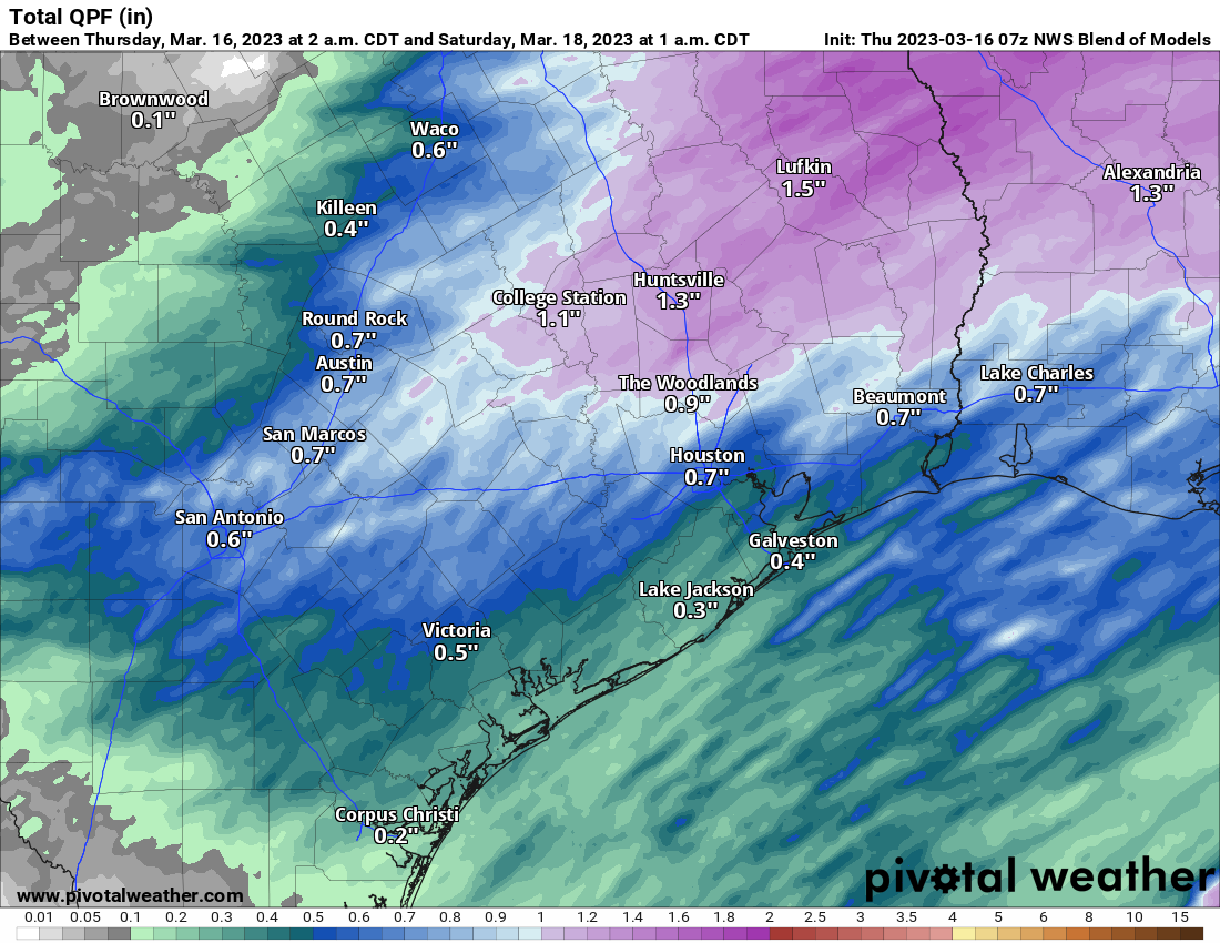
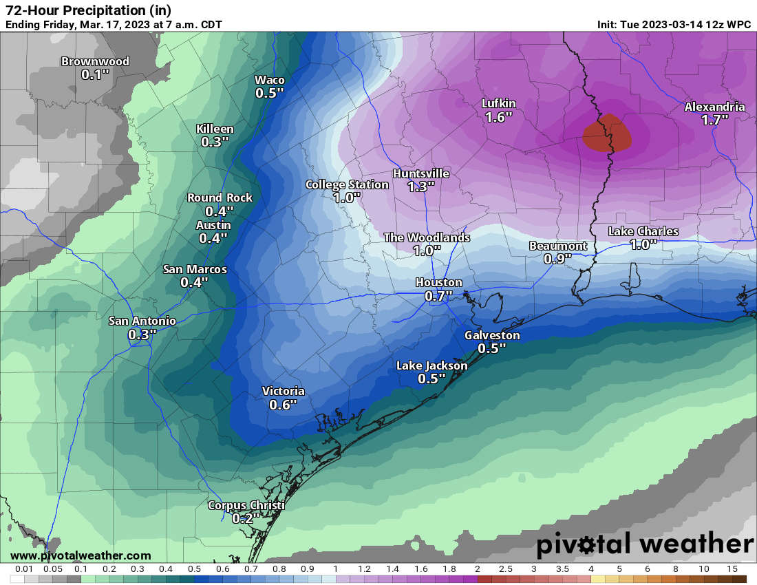
Total rainfall from Thursday and Friday’s storms will likely be a half inch or less south of I-10 and an inch or so north of I-10, although varying amounts are likely, both higher and lower than that. (Pivotal Weather)
Total rainfall from our front and storm system looks to be about an inch or less for most, but it will vary with higher amounts north and lower amounts south.
Weekend
So, this weekend looks intriguing. In terms of weather impacts, it looks minimal: It’s going to be mostly cloudy, chilly, and breezy most of the weekend. Expect lows in the 30s and 40s and highs in the 50s both days. If that’s all you need, skip ahead. Otherwise…
Meteorology geek-out: I am interested though to see if we can’t squeeze some showers out the passing rising air over our area, especially on Sunday. We’ve got some leftover “noise” and a stronger than normal jet stream in the upper atmosphere in the wake of Friday’s front. If we can produce enough lift in the atmosphere, we may be able to start squeezing out some precipitation. Given how cold it is aloft (temperatures at 5,000 feet over our heads will be running 20 degrees colder than normal) and how dry the air is, it’s entirely possible that we see ice pellets falling in any better organized showers on Saturday or Sunday, even with temperatures in the 40s or 50s. We’ll speculate more on that tomorrow or Friday.
Early next week
It would appear that we get one more reinforcing shot of cold air via another storm and front on Monday. Modeling has been indicating that in parts of interior Texas, even some snow or sleet could mix in with the rain. Again, we’ll cover that more later this week should it become more of an issue. But that’s probably not for the Houston area. Just expect a dreary, chilly Monday, followed by a milder and more pleasant Tuesday. We have a shot at 80 degree weather again by Thursday.
Yesterday ended up being an absolutely spectacular day for most of the area, except perhaps southwest of Galveston, which hung on to clouds. We maxed out at 71° officially at Bush Airport, making Monday our coolest day since February 18th! Today will be even cooler, as we battle some cloud cover. And we’re still watching a pretty good chance of some very cool air this weekend.
Today
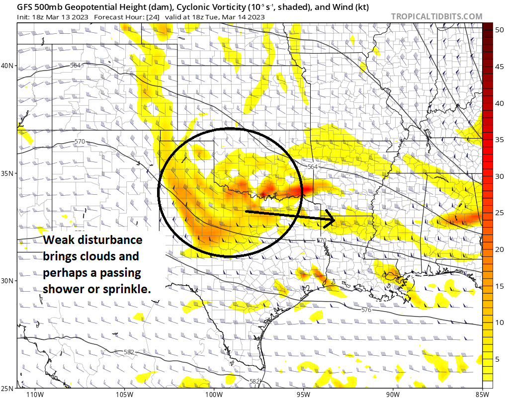
For Houston proper, today looks like a decent day. About 20,000 feet up today, a weak disturbance is going to cross the northern half of Texas, rotating around the base of a trough that’s helping supply a major snowstorm for the interior Northeast.
A disturbance passing through North Texas will bring a few clouds and slightly cooler air today. (Tropical Tidbits)
That disturbance won’t do much more than give us a few extra clouds and slightly cooler temperatures today, especially north of Houston. Based on morning satellite imagery, I’m not super impressed by the cloud cover this morning, so the day should start decent at the least. Highs will peak in the lower half of the 60s north of Houston and the upper half of the 60s south of Houston. We could do 70 or so from about Sugar Land south and west or anywhere that avoids clouds. The best chance for a shower or some sprinkles would be along or north of Highway 105, but we are probably talking meager stuff overall.
Bring a light JKT if you’re checking out MGK tonight at the Houston Livestock Show & Rodeo. Mid-60s or so walking in and near 60 as you head home. No weather woes again.
Wednesday
Between our current weather and the stronger onshore flow ahead of our next front, we get Wednesday, which looks just sublime. Chamber of commerce type weather, with sunshine, morning lows in the 50s and upper-40s (near 60 at the coast), then just mild and pleasant with low to mid-70s and Goldilocks humidity levels…not too dry, not too humid. Enjoy!
Thursday & Friday
On Thursday, you’ll notice the onshore flow increasing. Humidity will be going up, there will be more clouds, and we’ll likely see temperatures quite mild in the morning (60s), warming into the 70s to near 80° again on Thursday afternoon. A few showers or a thunderstorm are possible on Thursday, especially to the north and west of Houston.
The primary cold front that will be impacting us comes through Friday morning. Ahead of it, expect showers and thunderstorms to be likely. While locally heavy rain and locally strong storms are possible, we aren’t expecting any serious or widespread severe weather at this time. It could get a bit noisy late Thursday night and Friday morning though. We’ll continue to keep an eye on this in case things change.
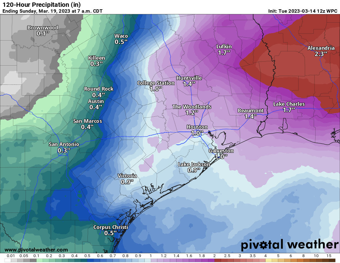
Rain totals from Thursday and Friday’s storms are likely to reach 1 to 3 inches across a chunk of the area. Not everyone will see that much, but most places should see at least some rainfall. (Pivotal Weather)
The big question on Friday is how much clearing we see. I think we’ll remain cloudy into early afternoon right now, but then possibly filter in some sunshine from northwest to southeast before day’s end. Friday’s high temperature will probably occur around or just after midnight, near 70 degrees, falling into the mid-50s by morning. Maybe we can warm to near 60 degrees Friday afternoon, but that would be quite optimistic.
One thing you’ll also notice Thursday and Friday? The wind. Gusts of 25 to 35 mph are likely across the area, with stronger winds possible over the water.
Weekend
Perhaps this will be our final real winter-like weekend of the season. Temperatures should bottom out in the 40s on Saturday morning, with some 30s possible north and west. We do not expect freezing temperatures, however. During the day, however, it will feel very un-March like. Our average high this time of year is up to the mid-70s. We may struggle to get into the mid-50s on Saturday with a lot of clouds and maybe a few pockets of light rain or drizzle.
Temperatures are going to be running 15 to 25 degrees or even more below normal values on Saturday afternoon across Texas. (Pivotal Weather)
Sunday will only be marginally warmer with morning lows again in the 40s mostly, daytime highs in the 50s, and a mix of clouds and sun. Another system is pegged for Monday before we warm up a good bit next week. More on all that tomorrow and Thursday.