Yesterday was something. There are still about 35,000 customers without power across the Houston area early this morning according to Centerpoint. We saw trees down, fences down, and more yesterday. Pasadena and South Houston saw just shy of 3 inches of rain. Officially, we had a couple 56 mph wind gusts reported, one in Cypress, one atop a building in the Med Center. Hobby and Bush Airports both gusted near 45 mph. Pearland hit 47 mph. San Leon topped off at 53 mph. A few stronger gusts may have occurred in between. We have some photos (and fun videos) shared by readers on our Instagram account. Feel free to tag us over there if you ever see something cool!
Today
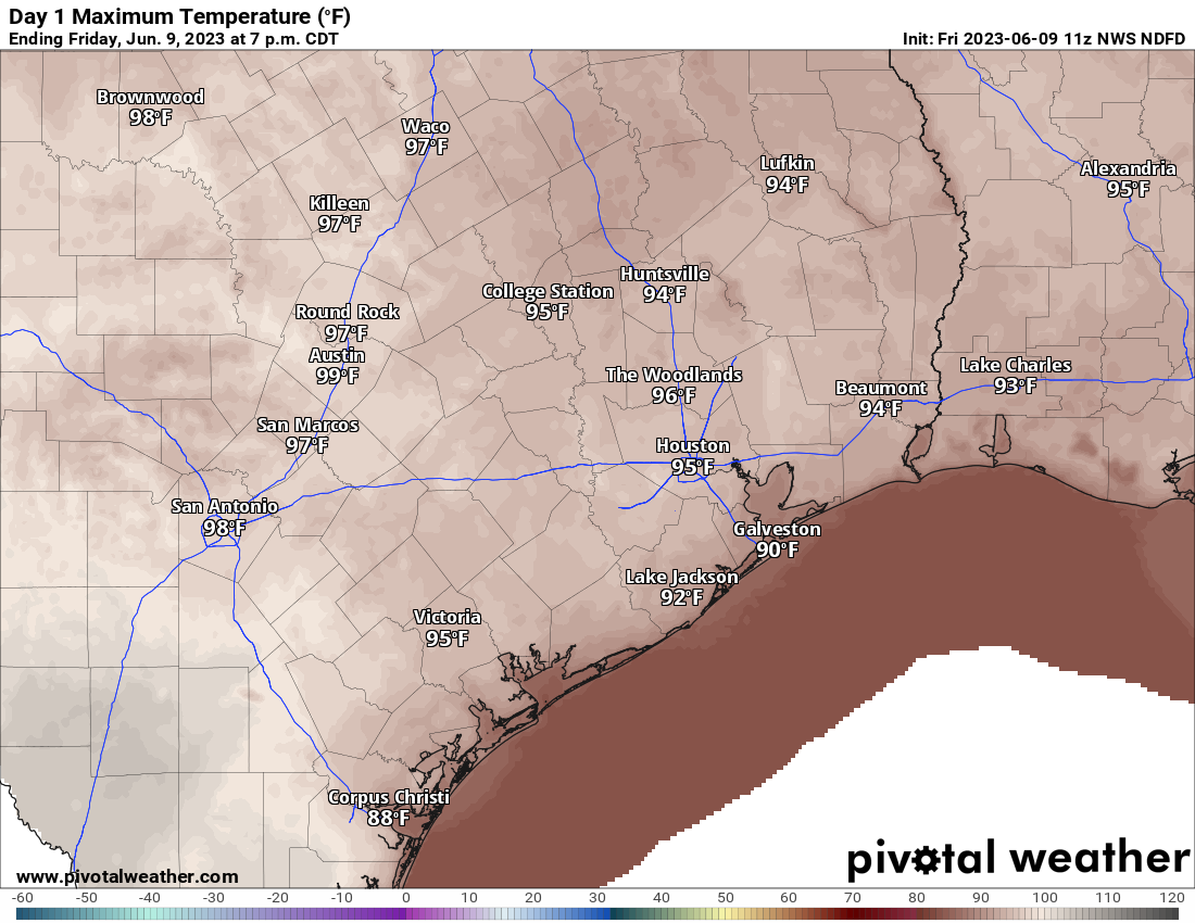
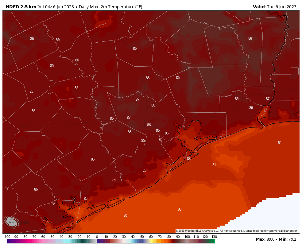
The good news is that we should have a much quieter day today. We will start to feel the heat creep up however with temperatures likely hitting the mid-90s this afternoon. Yes, look for a handful of pop-up storms later this afternoon, but it should pale in comparison to Thursday’s action.
I was an early teen in the mid-90s, and this will feel pretty uncomfortable too. (Pivotal Weather)
Saturday
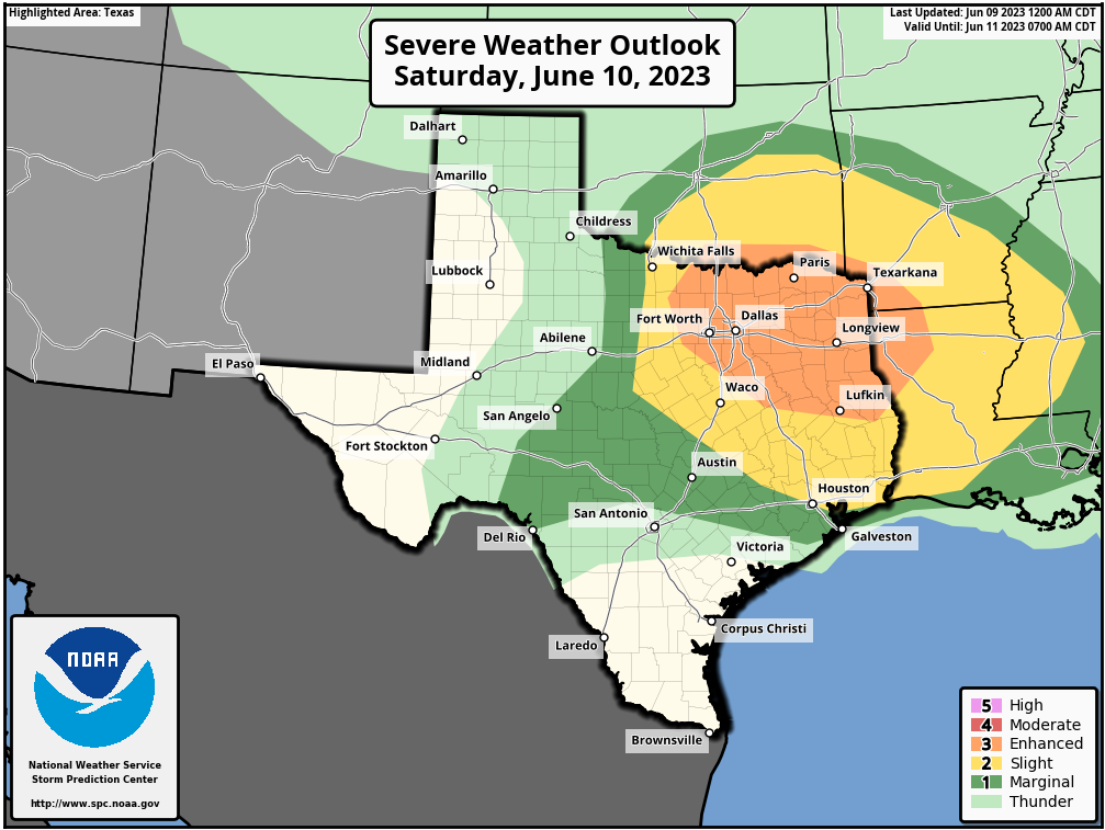
It continues to look as though a weak little disturbance will pass across Texas tomorrow, disrupting the growth of the hot ridge of high pressure out of Mexico and bringing a bumped up chance of storms, especially north of Houston. While I don’t think storms will have quite the punch in Houston as they did yesterday, some of these storms could easily be on the stronger side, so if you have outdoor plans Saturday afternoon, keep this in mind. The Storm Prediction Center has Houston proper split between a marginal and slight risk of storms, with the higher risk north and lesser risk south.
Houston is split between a marginal (1/5) and slight (2/5) chance of severe storms tomorrow, with the greater risk to the north of I-10. A higher risk of severe weather exists in the Metroplex into northeast Texas (NOAA)
We are again mainly concerned about the potential for damaging winds. There’s a good chance we’ll have a quick updated post for you tomorrow morning to better time and assess things. Outside of that, look for sun, clouds, and highs in the mid-90s with morning lows in the 70s.
Sunday through Tuesday
The pattern should stabilizes Sunday onward, dropping our rain chances down to about 10 percent or so and leading to temperatures in the mid to upper-90s. Some morning lows could be near 80 degrees. It’ll feel a bit rough. Again, practice heat precautions during this time, as we’re not yet quite acclimated to this sort of summer heat.
Wednesday through Friday
Temperatures should continue to creep upward later next week, with our peak odds of 100 degree weather coming on Thursday, Friday, and Saturday. At this point, we don’t see anything meaningful enough to wreck this forecast, so expect that the worst of the heat is yet to come.
Lastly: Yes, we are aware of a certain operational weather model frequently showing a tropical storm or hurricane in the Gulf in about 10+ days. Make sure you’re following our companion site, The Eyewall for more detail on the entire tropics, including things like this in fantasyland. Spoiler alert, we don’t believe it to be a legitimate concern.
Before we get into the heat, we still have a couple things to discuss, including the potential for a few stronger storms today. We’ll hit on that, but then we’ll assess the upcoming heat, how long it may last, and how hot it may actually get.
Today
For all intents and purposes, today may be like the last couple days have been in Houston: Hazy, sunny, then afternoon pop up storms. The haze is primarily a result of agricultural burning in Central America and southern Mexico. It does appear that air quality readings are a bit better this morning than they have been this week. Ground ozone will again be an issue today due to sunshine, warm weather, and light winds.
Today’s forecast is a bit more difficult than normal for this time of year. We have a lot of “juice” for thunderstorms, including healthy instability, a little bit of wind shear, and a lot of chaotic boundaries that may interact with one another this afternoon and evening.
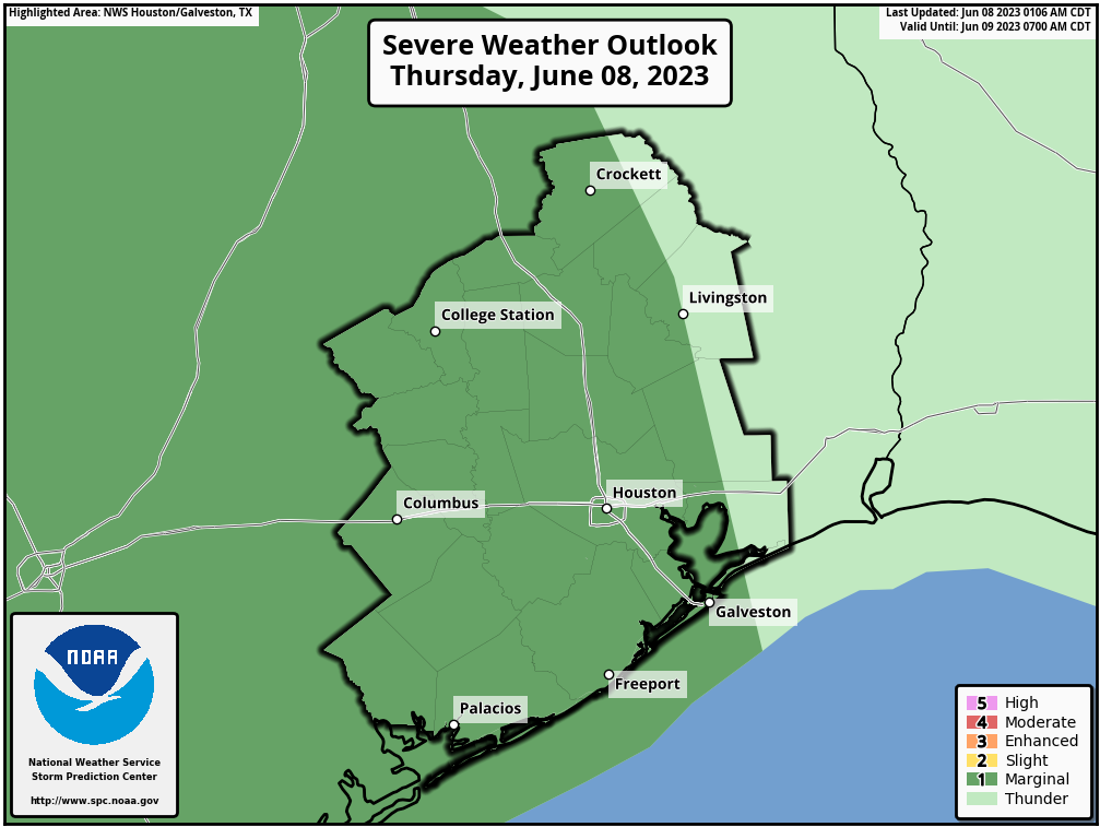
The Storm Prediction Center has us in a marginal (1/5) risk for severe weather today, with a lift to a slight risk (2/5) possible later this morning. (NOAA)
We will probably see storms begin to pop up after 12 to 2 PM as they have on most afternoons this week. From there, it’s very difficult to predict the exact evolution of things. Storms may interact with each other, in addition to old boundaries sitting over the area. We may also add in a cluster of new storms coming in from the north and west as well. Whatever the case, it would appear that some of us will be in for some stormy weather late this afternoon and early this evening. Have your umbrella and a place to sneak indoors available. If you have any late afternoon outdoor activities, have a way to get warnings and move inside if you hear thunder We saw numerous lightning strikes seemingly out of the blue yesterday afternoon near my house before storms had actually developed.
Aside from storms, look for highs generally in the low-90s today.
Friday
We will begin to see high pressure in the upper atmosphere build out of Mexico and into Texas tomorrow. This will allow for most places away from the coast to touch the mid-90s or even a bit hotter. Morning lows will be generally in the 70s.
Friday’s forecast highs are well into the 90s. Get used to it I’m afraid. (Pivotal Weather)
Rain chances will again be in the forecast, lower than today but not near zero. Some isolated stronger storms may again be possible, especially east of Houston toward Beaumont and Port Arthur.
Saturday
We interrupt this developing heat wave with a quick interlude. A weak disturbance will disrupt the burgeoning ridge of high pressure over Texas and probably increase rain chances a bit on Saturday afternoon or evening, especially north of I-10. Most places will probably stay dry, but there will be some areas that see downpours. We should still manage to get into the 90s on Saturday, after morning lows in the mid-70s.
Sunday through Tuesday
Hot and humid. Rain chances won’t quite be zero, but they’ll be exceedingly low. High temperatures on these days will be well into the 90s with morning lows in the mid to upper-70s, if not near 80 degrees in spots.
When we start talking upper 90s by day and near 80 by night, that’s when you can start running into heat stress issues. Please make sure elderly, young children, and vulnerable populations (and pets!) are tended to next week. Also, you too! Our bodies have experienced a pretty pleasant late May and June by Houston standards. We have not acclimated to true summer heat yet. This will hit us pretty good. Drink water, wear sunscreen, and take it easy outside.
How long does this last?
If you look at upper level maps, it appears we might have a brief chance at better rain chances and slightly cooler temperatures Wednesday and Thursday of next week as a weak trough flattens the ridge some. But it is expected to then reload heading toward next weekend, so it will be awhile we think.
How hot can it get?
I guess the better question is: Can we do 100 degrees? The answer is yes. The National Blend of Models has us at about a 65 percent chance of hitting 100 degrees next Thursday, Friday, or Saturday. But that’s not guaranteed. Things that could wreck that chance include soil moisture, more numerous afternoon storms than expected, and high clouds from an El Niño-driven stronger than normal southern jet stream.
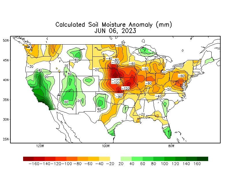
Soil moisture is running near to slightly above normal in East Texas and along the Texas coast. This could help to skim a little heat off the top, so to speak next week and shave a degree or so off our forecast temperatures. (NOAA)
Soil moisture is running near normal or even slightly above normal in our area. A drier ground heats up more efficiently, but more moisture in the ground can slow down that heating process a bit. Thus, this could be good for knocking a degree or so off temperatures next week. So maybe instead of 101°, we end up near 99-100° or so.
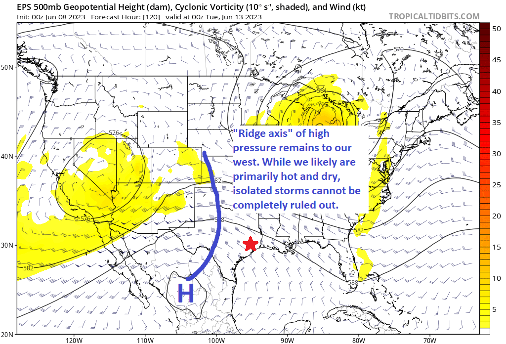
High pressure will be strong next week (this map is Tuesday’s forecast), but with Houston on the east side of things, we cannot entirely rule out an isolated shower or storm. (Tropical Tidbits)
The axis of high pressure for much of next week is centered over and just west of Hill Country. While Houston isn’t exactly on the periphery of that, there is always the chance that models are underdoing our rain chances some. Higher rain chances may yield slightly lower temperatures.
Lastly, the jet stream has been humming over Texas and Mexico lately. This is likely tied back to the developing El Niño in the Pacific. Anytime you have an active Pacific jet like this, you run the risk of high clouds. Should we get more of those than expected, look for a couple degrees knocked off high temps next week, but perhaps a degree or two added to nighttime lows. This would be true more so early on than later next week.
With all that said, I think there’s probably a better than 50 to 60 percent chance we hit 100 degrees next week, with multiple 98-99 degree days peppered in between. Either way, hot. Very hot.
Good morning. The overall pattern for Houston’s forecast remains the same. We’re going to have a couple of more days of fairly modest rain chances as high pressure starts to build over the area, and sends our temperatures upward. And the Houston region is still looking its first sustained period of hot temperatures beginning this weekend, and lasting through at least much of next week.
Wednesday
High pressure doesn’t have our region in a firm grip yet, so we’re going to see more moderate weather today, with highs of around 90 degrees and mostly sunny skies. The atmosphere is just disturbed enough that we could see some showers and thunderstorms break out during the afternoon hours with daytime heating. However, these storms should be more scattered than what has come earlier this week. I would peg daily rain chances at about 20 or 30 percent. Winds will be light, with lows dropping into the low 70s tonight.
Here’s our last day of temperatures at or just below 90 degrees. (Weather Bell)
Thursday
A day like Wednesday, with sunny skies and highs in the low 90s. This will probably be the final day that we really need to watch for thunderstorms to pop up during the afternoon hours, but there’s still a chance before high pressure clamps down.
Friday
Should be a mostly sunny day with highs in the low- to mid 90s.
Saturday and Sunday
This will feel more like a weekend in July or August, with sunny skies, high humidity, and high temperatures in the mid 90s. Since the Sun is now very nearly at its highest point in the year—the solstice comes on June 21—please protects your skin from 10 am to 4 pm at least.
It’s been nine months or so since we’ve felt the upper-90s. (Weather Bell)
Next week
The heat train rolls onward, and upward. Highs for much of next week should push into the upper 90s, with some inland areas recording their first century marks of the year. Rain chances look to be nil through at least the middle of next week, if not beyond. You wanted summer, Houston? You got it.
Good morning. Before jumping into today’s post, I want to thank our long-time sponsor, Reliant, for their kind words about our new Atlantic hurricanes site, The Eyewall. Please check out their message at the end of this post, which has some good ideas about preparing for the 2023 Atlantic season in Houston. As a reminder, Reliant has sponsored Space City Weather since 2017—helping us keep the lights on literally and figuratively.
Tuesday
Following fairly widespread storms on Monday, the atmosphere remains disturbed today. As a result we should see another round of showers and thunderstorms during the afternoon hours today. However, I think coverage and intensity will be a bit less, with perhaps 50 percent of the region seeing rainfall. Partly to mostly cloudy skies this afternoon should limit high temperatures into the mid- to upper-80s. Winds, outside of thunderstorms, should be light. Lows tonight will drop to around 70 degrees.
Here’s your high temperature forecast for Tuesday. How long will it be before we see temperate weather like this again? (Weather Bell)
Wednesday
This will be a bit of a transition day, with some scattered showers and thunderstorms, and partly sunny skies. Look for high temperatures near 90 degrees.
Thursday and Friday
As high pressure moves in, temperatures will go up. And truth be told, we’re going to flip a switch and go into full-on summer, with mostly sunny skies and highs in the mid-90s. Nighttime temperatures will be noticeably warmer too, bumping up into the mid-70s with that sultry humidity you know and either love or loathe. (Yes, some people do love the Houston humidity). Rain chances each day will be about 10 percent with the afternoon sea breeze.
Saturday and Sunday
More of the same. We’re taking highs in the mid-90s, sunny skies, and humidity.
Oh no? Oh yes. (Weather Bell)
Next week
Not to end this forecast on too much of a downer, but there is some question about how much hotter it might get next week. The upper 90s, probably. It’s a tiny bit early for 100-degree heat, but certainly not unprecedented. It will feel like a blowtorch regardless. Welcome to summer 2023, y’all.
Sponsor message
Congratulations to Eric and Matt on the launch of The Eyewall to bring the same no-hype forecasts we value so much here in Houston and Southeast Texas to even more coastal residents. At Reliant, we’re honored to have supported Space City Weather since 2017, keeping the site free and available to everyone year-round! Along with our fellow Houstonians and local businesses, their forecasts keep us informed and prepared in both calm and stormy weather.
As we’ve now officially entered the 2023 hurricane season, we want to remind readers that Reliant stands ready to support Texans and help prepare for any storms that come our way. Especially early in the season, it’s important to take the time to protect your family, home, and business in advance. Reliant’s Severe Weather Prep Checklist is a good place to start.
Here are a few other tips to keep in mind as you prepare:
Reliant offers a wide range of backup energy solutions to help you ride out the storm. Have power at the ready — at home or on the go — with Goal Zero portable charging products. They can charge everything from phones to fridges and even life-sustaining medical devices.
Be prepared in case of an electricity outage. Your utility company (like CenterPoint in the Houston area) maintains the power lines, utility poles, and other electricity infrastructure necessary to deliver the power you purchase from Reliant to your home. Contact your utility company to report an outage or check the status of a repair.
Check out more preparedness tips and recovery resources at ReliantStormCenter.com. The site provides resources for before, during, and after a storm, including preparedness checklists and evacuation routes, weather and power outage updates, flood maps, safety tips, and more.
Just like the summer heat, storms are a part of life in Texas, so being prepared is critical. Like everyone else, we are hopeful this season will be a quiet one, but come what may, Reliant and Space City Weather will be here for you.