The first of two fronts arrives today, bringing clearer and colder weather to end the week

Good morning. Houston will see scattered showers today, with a chance for thunderstorms, as a cold front slogs into the region. This will usher in a period of colder and clearer weather through about Sunday morning, after which time we’ll warm back up for a few days. So it goes in February, in Houston.

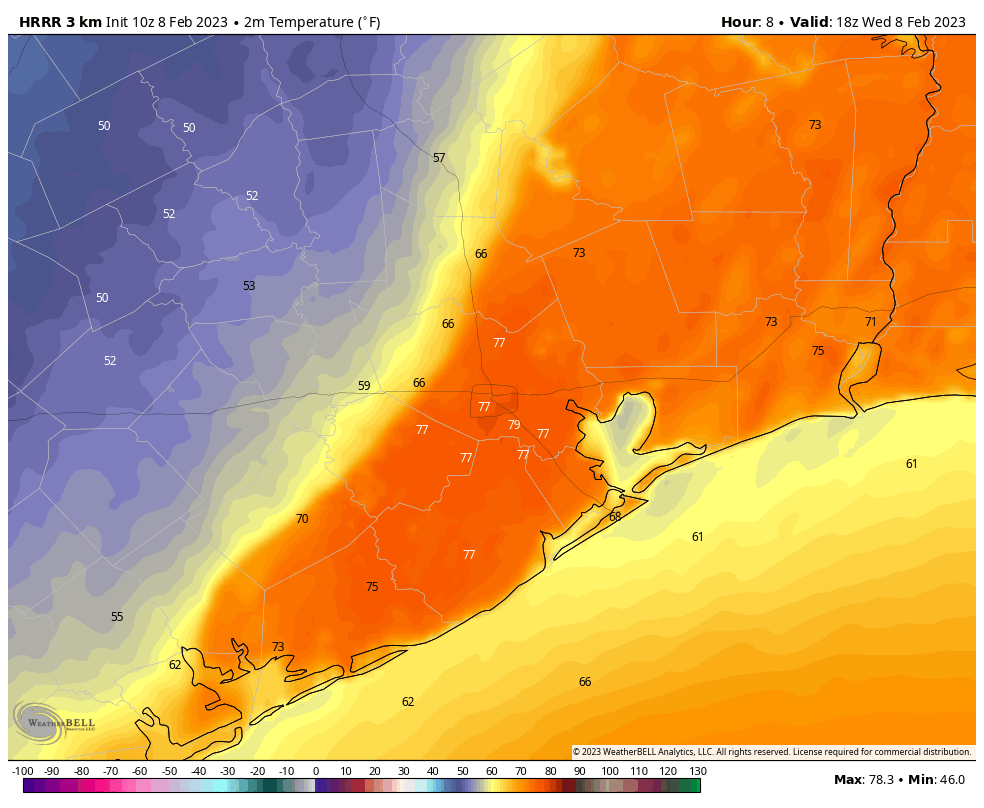
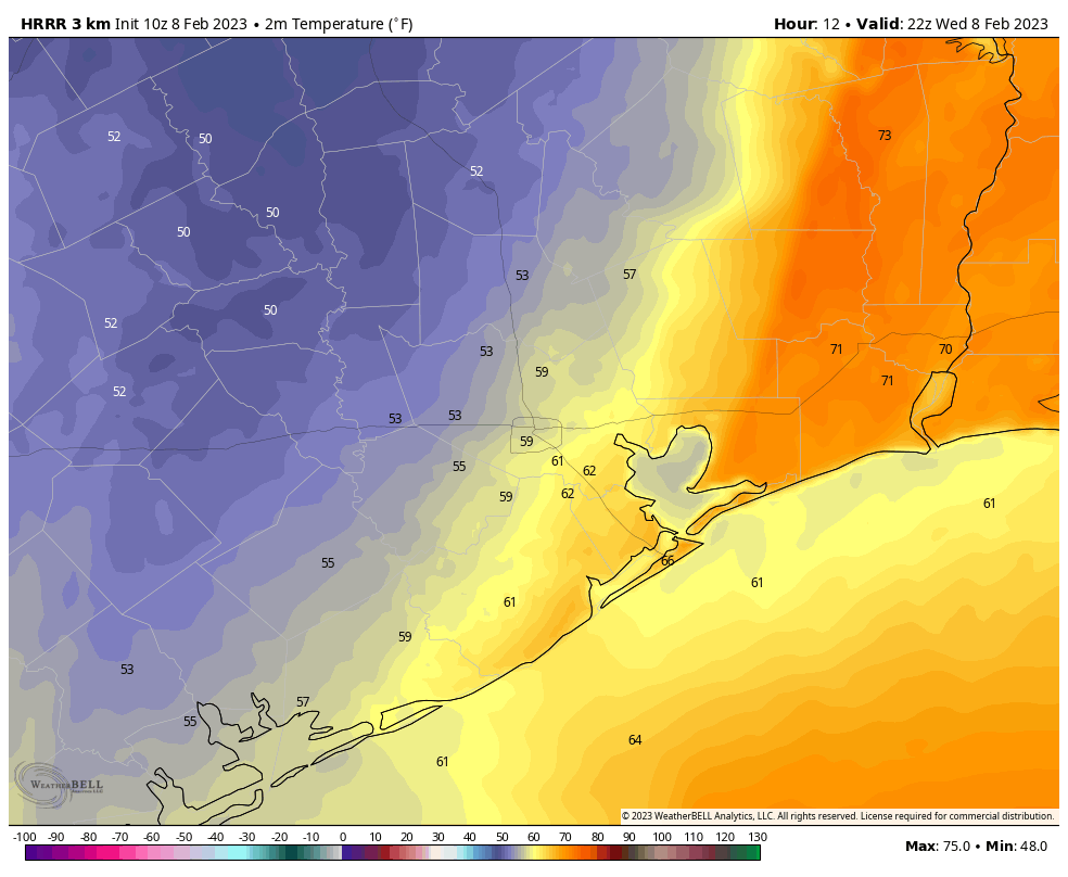
When cold fronts pass through the region during the daytime, we often say that highs will depend upon your location, and the timing of the front. Today offers a textbook example of this, with a midday frontal passage. If you slide the image below, you’ll see the temperature forecast for noon and 4 pm CT. Already, at noon, temperatures in areas such as Katy and parts of Montgomery County will be in the upper 50s. For central and eastern parts of the Houston region, however, temperatures will be 20 degrees warmer. By late afternoon some eastern parts of the region will still be in the lower 70s, while most of Houston has dropped into the 50s.

HRRR model temperature forecast for noon (left) and 4 pm CT.

Wednesday

As noted above, temperatures today will depend on where you live and the timing of the front. In terms of rainfall today, most areas will see on the order of a few tenths of an inch of rain. However, high resolution models are hinting at the potential for some isolated thunderstorms through the early afternoon hours, so these may briefly produce heavier rain and lightning. Please take care in such storms. Low temperatures tonight will drop into the mid-40s as colder and drier air moves in.

Thursday

This will be a sunny, splendid day with highs near 70 degrees and plenty of sunshine. Winds will be fairly light, shifting to come from the southwest. Lows again will drop into the mid-40s. On Thursday night a reinforcing cold front will arrive, setting the stage for even colder conditions to end the work week.

Friday

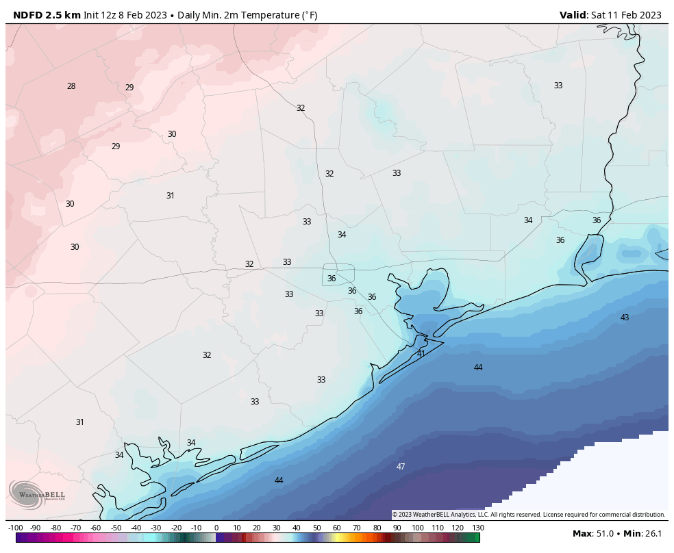
Behind this second front an even colder and drier air mass will move in, and as a result Friday is going to be a chilly and gusty day. Look for highs to only reach the mid-50s, with wind gusts as high as 25 or 30 mph, or even slightly higher along the coast. These winds will back off some on Friday night, setting the stage for a very cold night, with a light freeze possible for inland areas. Expect sub-freezing wind chills, so this will be a cold night to be out and about.

Low temperature forecast for Friday night into Saturday morning. (Weather Bell)

Saturday

Expect a sunny and cool day, with highs in the mid- to upper-50s. Lows on Saturday night probably will be 1 to 3 degrees warmer than Friday night.

Sunday

As the overall flow turns more southerly, expect highs on Sunday to reach the low 60s, with partly to mostly sunny skies. Lows on Sunday night will drop to around 50 degrees in Houston.

Next week

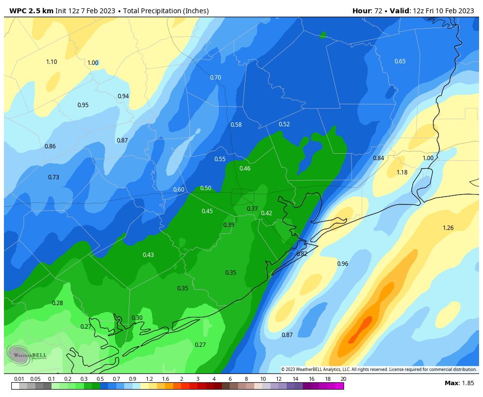
The forecast for next week remains far from certain, but a general pattern is emerging. Monday and Tuesday will warm into the 70s, and as moisture levels start to increase we’ll see an upper-level system move in that should generate fairly widespread showers. Very roughly I’d ballpark rain accumulations at 0.5 to 1 inch. This system may or may not drag a weak front into the region, but then we should warm up on Wednesday again before a somewhat stronger front pushes into Houston by Thursday-ish. Accordingly, lows likely will drop back into the 40s toward the end of next week.

A slow moving front will bring some scattered, but potentially strong storms to Houston tonight

Good morning. Houston faces a period of unsettled weather tonight and Wednesday before the first of two fronts clears out our skies through Saturday. A freeze is probably not in the cards for most of the metro area on Friday night, but some inland areas are at risk. Keep a jacket handy.

Tuesday

We’re seeing some patchy fog again this morning, so take care on roadways where there is limited visibility. Otherwise, skies today will be mostly cloudy across Houston, with a warm February day in the mid- to upper-70s. Winds will be out of the south and southeast, gusting to perhaps 20 mph. Some very light, and fairly scattered showers will be possible today and this evening, with most of this activity occurring on the west side of the metro area. Rain chances will increase tonight, especially after midnight, with the approach of a front.

NOAA rain accumulation forecast for now through Wednesday. (Weather Bell)

Wednesday

The thing with this front is that it’s going to be moving pretty slowly, likely reaching areas such at Katy and The Woodlands by around sunrise on Wednesday, but not pushing off the coast until Wednesday afternoon or evening. Therefore, while the ingredients for heavy rainfall and severe storms are lacking overall, there probably will be a few areas where such storms develop and stall. Put another way, much of the metro area will likely receive about one-quarter of an inch of rainfall. However, some smaller areas may pick up 2 inches or so, with higher amounts possible, as storms stall. The most likely time and place for these heavier rains is between midnight and sunrise on Wednesday, to the west of Interstate 45.

Most of the central and eastern parts of the region will reach high temperatures in the 70s on Wednesday before the front slogs through, bringing cooler and drier weather. Cloudy skies should clear out overnight on Wednesday, with low temperatures dropping into the 40s.

Thursday

Look for sunny skies, with highs in the upper 60s to 70 degrees, and plenty of dry air. This will be a fine day, with light winds out of the west. Overnight lows will drop into the mid-40s. A second cold front will arrive on Thursday evening, which will be noticeable as winds pick up, gusting from the north at 25 to 30 mph later on Thursday night.

Friday

This will be a sunny, cold day in the wake of the second front. Highs likely will not top the mid- to upper-50s, with a brisk wind all day. Lows will plummet into the mid-30s on Friday night as winds start to pull back some. Some inland areas will be at risk of a light freeze.

Low temperature forecast for Friday night. (Weather Bell)

Saturday and Sunday

Saturday will be a fine winter day, with highs of around 60 degrees and sunny skies. Overnight lows will be a few degrees warmer than Friday night, but still chilly. However, as the onshore flow resumes, temperatures will start to moderate on Sunday, with highs in the mid-60s and increasingly cloudy skies. Sunday night’s lows probably will drop into the 50s.

Next week

The forecast for next week is a bit muddled, but generally I think we can expect a fairly wet period on Monday and Tuesday, with cloudy skies and pretty healthy rain chances. Highs for most of next week look to be in the 70s. A weak front is possible mid-week, but more likely we’ll have to wait until the latter half of the week for a noticeable cooldown. We’ll see.

Expect decent rains this week ahead of the next cold front

Good morning. After a mostly sunny weekend, some clouds return today, along with a continued warming trend that will push highs into the mid- to upper-70s. The Houston area will see widespread rainfall on Tuesday evening through Wednesday morning, which will bring in the region’s next cool front. This will bring a couple of chilly nights, with lows perhaps in the mid- to upper-30s.

Monday

There is a bit of fog out there, nothing too dense, but take it easy if you run into limited visibility this morning. High temperatures today will climb into the mid-70s beneath partly sunny skies. Later this afternoon you’ll notice winds out of the south, gusting up to 25 mph. This will bring increasing moisture levels that will help set up our next chance of rain showers starting later on Tuesday. Clouds will increase Monday night, with lows dropping only to around 60 degrees in Houston.

A few areas may reach 80 degrees on Tuesday ahead of the next front. (Weather Bell)

Tuesday and Tuesday night

Fog will again be possible on Tuesday morning, and despite mostly cloudy skies this should be our warmest day of the week. Look for high temperatures in the upper 70s, with a few inland areas possibly touching 80 degrees. Most of the daytime should just be gray, but by the afternoon hours we should start to see some scattered, light showers. These may increase in intensity after midnight, as the front approaches and moves into Houston by around sunrise. Lows on Tuesday night will only drop to around 60 degrees ahead of the front.

Wednesday

Rain showers should exit the area pretty quickly after the front’s passage on Wednesday morning, by around noon at the latest. The model guidance for total rain accumulations from the front are all over the place, from less than 0.5 inch to 2 inches. My sense is that a few areas will see heavier rain and thunderstorms, but that the majority of the region will see about 0.5 inch of rain give or take. The bottom line is that I don’t expect this event to be too impactful, although the additional rains will keep yards on the wet side. I’m not anticipating any flooding issues right now. Winds will be breezy out of the north after the front, gusting perhaps to 25 mph. Highs Wednesday will be in the 60s, with nighttime lows falling into the mid-40s for most.

Thursday and Friday

These will be a pair of sunny days. Thursday will be in the 60s, with light northerly winds, and another night in the mid-40s. Friday, however, will be more blustery, with a reinforcing blowing into the area. I don’t expect any rain with this front, but Friday could be gusty with winds blowing up to 30 mph and highs only in the 50s. As temperatures drop into the upper 30s on Friday night, these gusty winds will quickly cool you off. Outdoor activities are not recommended Friday night, therefore.

Friday night’s low temperatures are shown here. With the winds, it’s going to be quite cool. (Weather Bell)

Saturday and Sunday

The first half of the weekend will be sunny and cool. Next Saturday will, in fact, be a lot like the Saturday just past, with highs near 60 degrees, probably. However, as winds shift to come from the east this weekend, it will set up a more moderate flow for Sunday. As a result look for building clouds on Saturday night, and highs in the mid- to upper 60s on Sunday

Next week

Most of next week looks warmer and cloudier. Monday and Tuesday should see decent rain chances in response to an upper-level system, and I’d look for highs in at least the 70s through much of the week. It is too early to say with any confidence whether a mid-week front will make it all the way through Houston.

Let there be sun, Houston! Soon.

The last time Bush Airport reported anything other than overcast or broken overcast skies was back on the morning of January 27th. That week-long streak will end at some point today. Most of the area will see at least some sun, if not full sun before the end of the day, and everyone sees sunshine tomorrow. In addition, we’ve gone over 100 straight hours below 50 degrees, not a particularly big deal, but it has certainly been cold and quite damp. That should end today also. All in all, if you have weekend plans, you can confidently go forth with them.

Today

Most of the area remains under low clouds this morning. You have to get east of about Wallisville and Anahuac or west of Flatonia on I-10 to get into clearing.

Satellite as of 7 AM shows that clouds still dominate, but they will lose ground as the day goes on, allowing the sun to take hold. (College of DuPage)

The clouds will erode through the day today, allowing the sun to emerge. I think they’ll probably dissipate from east to west through the morning and afternoon. Areas most likely to stay cloudy most of today are probably west of Houston. Once the clouds diminish, look for temperatures to rebound into the 50s over most of the area. Places that stay under clouds may only get close to 50 degrees. Winds will be light in most spots but perhaps a bit gusty over the open water.

Weekend

Both Saturday and Sunday should feature more sun than clouds. Winds will flip back onshore on Sunday, which may allow for a few extra clouds. So Saturday will start chilly, with 30s in most of the area, but we should warm to near 60 or so. But Sunday will start in the 40s and warm to near 70 degrees.

Saturday morning low temperatures should bottom out in the 30s in most places away from the immediate coast. (Pivotal Weather)

Just a quick note: Models do predict some fog may develop tonight north and west of about Cypress. Anyone in places like Navasota into Bryan or College Station and north toward Huntsville, just be advised that there could be temperatures at or below freezing with fog. That could make travel a bit slick late tonight and early Saturday morning. Once the sun comes up, it will improve quickly. This should not affect the Houston area.

Early next week

Monday should be partly to mostly sunny and warm. You’ll notice a little more humidity creeping back through the day, and there may even be some patchy fog development on the coast. Most places will top off in the 70s. Tuesday should be even warmer despite more clouds, with AM lows in the 60s and daytime highs around 75 or a few better in spots. Again, some fog is possible along the coast.

Next front

Consistent with Eric’s post yesterday, it looks like we can pencil in the next front for Tuesday night or Wednesday. The timing and details still need to be sorted out, but at this point we are looking for showers and storms in some window between Tuesday night and Wednesday afternoon, followed by cooler, drier air to close out next week. Or at least that’s the line of thinking we’re going to sell to you today. Some models bring back rain chances as soon as Friday, so we’ll see. More on Monday!

Rest of Texas

Interior Texas can continue to thaw out today and begin to assess and repair the damage left behind from this week’s ice storm. There are still nearly 250,000 customers without power across the state. If you plan to travel toward Dallas or Austin or San Antonio or El Paso, road conditions should be clear today through the weekend. As always, check with drivetexas.org for the latest information.