Good evening. This is just a quick post to say that we no longer anticipate the threat of widespread, heavy rainfall in the Houston metro area tonight and on Friday, including most of the coast. Therefore we are lifting the Stage 1 flood alert presently in place for coastal areas. This afternoon and evening, high-resolution forecast models have continued to trend eastward with the heaviest precipitation from a tropical system, away from the Houston region, and we can no longer justify such an alert.
Speaking of the tropical system, it has now moved inland into South Texas, and should turn more or less northward. We therefore expect that its heaviest rains will remain offshore for the most part, before impacting eastern Texas, including the Beaumont and Port Arthur areas, as well as southwestern Louisiana during the next 24 hours.
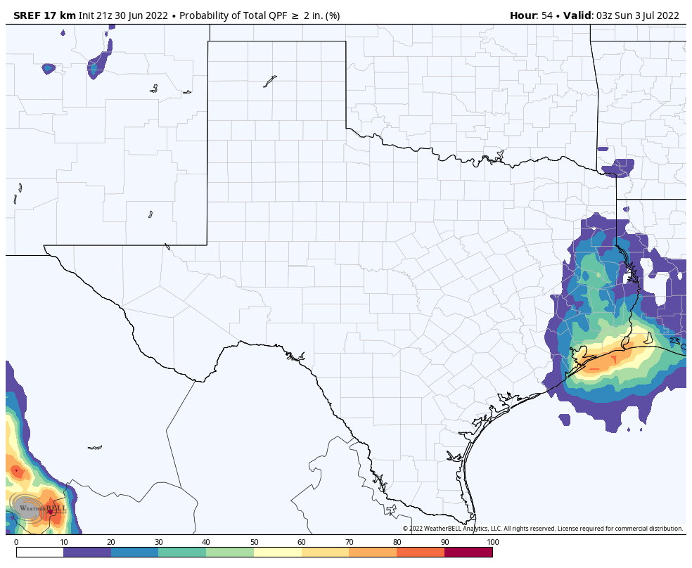
Probability of a region seeing greater than 2 inches of rain from now through Saturday. (Weather Bell)
That is not to say that Galveston and Chambers counties won’t see rainfall. But I now anticipate that 1 to 4 inches will fall along these coastal areas, with the potential for greater totals and more significant flooding off to our east. As for the city of Houston itself, Harris County, and the rest of the metro area, we’re just not seeing a strong signal for heavy rainfall. A few areas of the city may see 1 to 2 inches of rain tonight and on Friday, but for the most part we should see considerably less. Impacts likely will be minimal.
While we have tried to be careful to emphasize the uncertainty in this forecast in recent days, and the likelihood that rains would be most prevalent along the coast, I know a lot of you were hoping to get some drought-busting rains with this tropical system. In that sense, I am sorry to say, it is likely to be a bust.
Good afternoon. With this post we will provide an update on rainfall expected tonight and Friday, before our region dries out and starts to heat back up this weekend. The bottom line: We are maintaining a Stage 1 flood alert for coastal counties through Friday. The biggest change in this afternoon update is that our area of greatest concern has shifted eastward: We now expect the heaviest rainfall from now on to be focused on Galveston Bay and points eastward.
As expected, the rainfall today has been largely focused along the coast. Whereas most of the metro area north of Interstate 10 has not seen more than a few stray drops, parts of Galveston Island have received as much as 4 inches. This trend is largely expected to continue as a tropical system moves northward, continuing to push a river of atmospheric moisture on shore. Because we expect such a wide variance in outcomes, let’s break the forecast down for two different areas: the coastal counties of Galveston, Chambers, and Orange; and everyone else, including Houston.
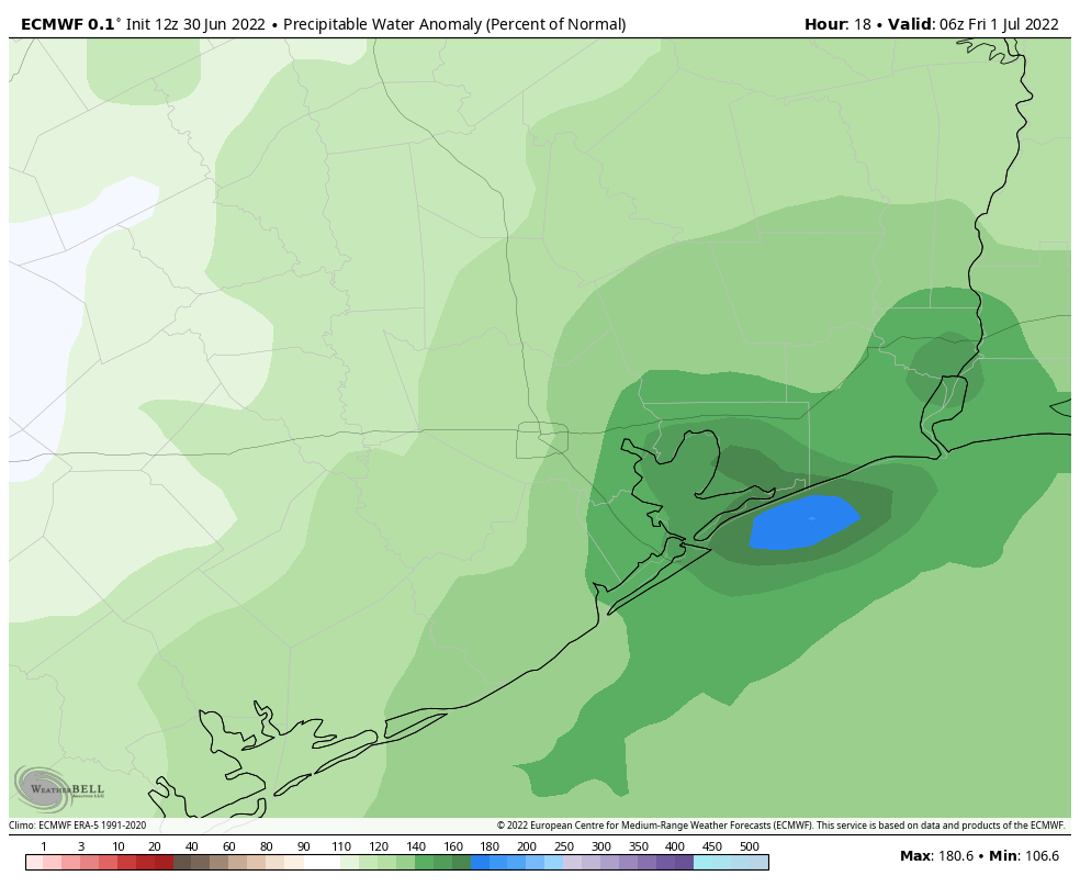
This forecast for precipitable water, a measurement of the moisture in the atmosphere, indicates where the greatest potential for heavy rainfall will be tonight. (Weather Bell)
Galveston, Chambers, and Orange counties
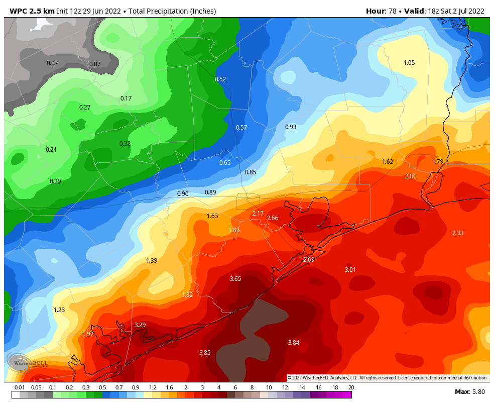
Forecast modeling has zeroed in on these areas bearing the brunt of heavy rainfall, most likely from about midnight tonight and running through Friday afternoon. Locations in these counties may see between 2 and 8 inches of rainfall during that time period, and despite the dry soils the most intense rainfall rates will nonetheless quickly back up streets. (This kind of tropical moisture is capable of producing intense rainfall rates of 2 to 4 inches per hour.) If you live in these areas, you should definitely check the radar before getting on the road tonight and Friday. While things may be fine, there’s also a chance they might not be. The worst should be over some time on Friday afternoon.
Houston, Harris County, and other parts of the metro area
For everyone else the rain showers are likely to be far more spotty, and the impacts minimal. Expect a day on Friday to be pretty much business as usual. While we could see a few areas away from the coast pick up some significant rain accumulations, it would not surprise me to have much of the inland parts of our region stay below one-half inch of rain. This is especially true for locations inland of Highway 59/Interstate 69. It just looks like the moisture is going to get shunted off too far to the east to really provide meaningful rainfall to those areas. I know, our lawns and trees could certainly use a lot more.
If needed, Matt will have an updated forecast later tonight. If not, look for a post early Friday morning to catch you up on the latest.
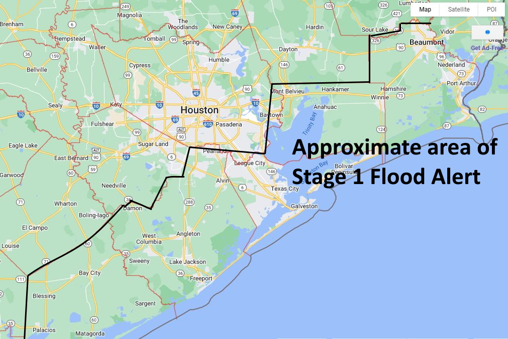
Good morning. A tropical low pressure system is nearing the South Texas coast this morning, and should begin to move inland today. As a result, beginning tonight and on Friday, much of the Houston metro area is likely to see moderate to heavy rainfall. But the biggest threat should come in our coastal counties: Matagorda, Brazoria, Galveston, Chambers, and Orange. Therefore, for these areas we are issuing a Stage 1 flood alert on our Flood Scale.
Broadly speaking, we expect 4 to 6 inches of rain for coastal areas, which is a lot for two days, but since these areas have been so dry the totals should be manageable. However, some model data indicates the potential for coastal areas to see larger bullseyes of rain with this tropical air mass, and we are monitoring this closely. Suffice it to say that we may need to increase the flood alert later today to Stage 2, but do not feel confident in doing so now. (These bullseyes could also very well miss offshore). We plan to update you later today as we know more.
Approximate area of Stage 1 Flood Alert. (Google Maps/Space City Weather)
The remainder of the metro area should see more moderate totals of rainfall over the next two days, generally 1 to 4 inches, with amounts decreasing the further inland you go. We do not expect to need to issue any flood alerts for these areas, but again we are watching closely.
Thursday
We have seen some coastal showers develop prior to sunrise and push inland, but this activity will probably wane later this morning. Additional scattered showers and thunderstorms are possible this afternoon, but none of these are likely to be too organized. Therefore we think today should be business-as-normal for most people, and most activities. Look for highs in the upper 80s with mostly cloudy skies. The threat of heavy rain from the tropical system probably will not arrive until at least midnight along the coast, and a bit later than than that for inland areas.
Friday
Right now we think Friday will yield the most hazardous weather in terms of heavy rainfall. The key question, as we’ve been saying for a couple of days, is where the tropical low ultimately moves and brings its excessive moisture. We could find ourselves in a situation where the heaviest rain remains largely offshore, or we could find ourselves in a situation where Galveston Island receives 10 inches. What we can say for certain is that there is the potential for very heavy rainfall on Friday for coastal counties, with lesser chances as one moves into Harris County, and lesser chances still further inland. The potential for heavy rainfall should exit coastal areas on Friday afternoon or evening, and move north as the system is also moving to the north or northwest.
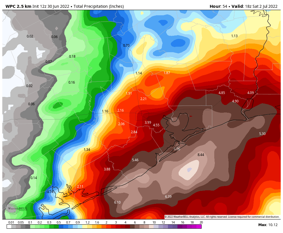
NOAA rain accumulation forecast for now through Saturday morning. (Weather Bell).
Saturday
The potential for widespread, moderate to heavy rainfall will linger on Friday night into Saturday morning as the tropical low starts to move away from the area, but we should start to see skies clearing out during the afternoon hours, allowing highs to reach about 90 degrees.
Sunday and Monday
The remainder of the weekend should see mostly sunny skies, with highs in the low- to mid-90s. There is a slight chance of rain both days, but I would only put it at 10 to 15 percent. Therefore, there should be no weather concerns for the Fourth of July holiday.
Next week
Houston’s weather will fall back into a hot and sunny pattern for most of the rest of next week, with highs probably in the mid-90s, or thereabouts. It will be a little warm for early July, but not excessively so.
We will post an update on the potential for flooding on Thursday afternoon or evening.
Houston’s warmest June ever is going to end much cooler than it started. With an increase in cloud cover, and at least decent daily rain chances, the next four days will generally see high temperatures of only around 90 degrees, give or take. The bigger question remains rain totals as a low pressure system approaches the Texas coast. Between now and Saturday I would expect 0.5 to 2 inches of rain for inland areas north of Interstate 10, and 1 to 4 inches for areas closer to the coast. But there will be wide variability across the region, and a lot still depends upon the movement of the tropical low over the next few days.
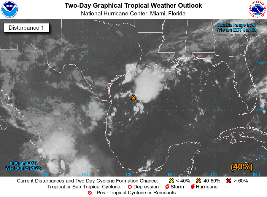
The location of the tropical low pressure system on Wednesday morning. (NOAA)
Wednesday
The aforementioned low pressure system is a couple of hundred miles due south of the Texas-Louisiana border this morning, over the Gulf of Mexico. And that’s where the bulk of the rainfall is, offshore. Still, we’ve seen coastal areas getting clipped by rains moving inland early this morning, and that could happen again this afternoon and early evening. If you live inland, north of Interstate 10, rain chances are less today, but not zero. Highs will generally reach the low 90s, beneath mostly cloudy skies. But if some sunshine pokes through this afternoon, a few locations could reach the mid-90s. Light winds (except in thunderstorms) will shift from the northeast to southeast later today, and rain chances may slacken over night.
Thursday and Friday
These two days still look like the best time for moderate to heavy rainfall to fall along upper Texas coast. This is when the tropical low pressure system—which has a 40 percent chance of becoming a tropical depression, the National Hurricane says—should come onshore somewhere along the middle Texas coast. Again, the most favored regions for heavy rainfall will be coastal counties, including Matagorda, Brazoria, and Galveston. However, the best chance for inland rainfall will also come on these days, as the tropical system marches inland. Our rainfall totals will ultimately depend on whether the system makes a northward jog, in which case some coastal areas could see 5+ inches. At this point, we just can’t say for sure.
The increased cloud cover and widespread rain should help to keep temperatures in check, with daily highs perhaps not making it beyond the upper-80s for a lot of locations. Enjoy the reprieve from the heat, which we certainly earned after a torrid June.
NOAA rain accumulation forecast for now through Saturday morning. (Weather Bell)
Saturday, Sunday, and Monday
For many this will be a holiday weekend. It is looking like we’ll see a carryover of rain chances into Saturday morning, but at some point they’re going to end and our skies will likely turn sunnier. Highs on Saturday will be around 90 degrees. Sunday looks partly to mostly sunny, with highs in the low 90s, and the Fourth of July should see partly to mostly sunny skies with highs in the mid-90s. We can’t entirely rule out a fleeting shower on these days, but I’d put the chance down in the 10 percent range. Note that while Harris County Commissioners did vote to enact a burn ban on Tuesday, fireworks will remain legal in the unincorporated part of the county.
Next week
Most of next week will likely see highs in the mid-90s, with mostly sunny skies, and precious few rain chances. So be sure and top off over the next several days, if you can.