Has it been extra windy in Houston this spring?

Happy Monday, everyone. There’s a lot to get to today, from a discussion of our recent windy conditions to warm Easter Sunday weather to the happy possibility that spring-like weather—we’re talking cool and dry nights—may not be done with us yet.

An extra windy spring?

Let’s start with the wind. After breezy northerly winds on Thursday and Friday of last week, the onshore flow returned with avengeance this weekend. On Sunday, wind gusts easily reached 40 to 45 mph and above in some locations. No fewer than three people e-mailed this weekend asking if Houston was having an abnormally windy spring. And I’ve wondered the same thing myself, so let’s investigate. If we look at “normal” winds over the last 30 years, we can see the the highest winds come during the months of February through May, with the peak in April. The average wind speed for April, in Houston, is 8.9 mph. In the chart below, the top row shows the average wind speed for each month, from January through December, in Houston.

Now let’s look at the current year. In February, this year, the average wind speed was 8.7 mph, so a little bit above normal; in March it was 9.3 mph, a little bit more above normal; and so far in April, the average wind speed has been 9.7 mph, nearly 10 percent faster than normal. So by the most basic metric, yes, this spring has been windier than normal. And since spring is already typically the windiest season in Houston—when we often see sharp gradients between the warmer Gulf and colder plains—your perception that it’s quite blowy outside is justified.

Monday

Today will bring mostly cloudy skies and a continued southerly flow. The winds will not be as extreme as on Sunday, but I expect that much of the area will still see gusts in the range of 20 to 30 mph today, especially as we get toward late morning into early afternoon. Despite the clouds, highs will likely get into the mid, or possibly upper 80s today. Most likely, a capping inversion will prevent the development of showers and thunderstorms today (Edit: as of 7:30 am it looks like the cap has broken for central Houston. This is somewhat of a surprise, but I still don’t think storms will be too widespread later today). Lows tonight will probably drop to around 70 degrees in Houston.

Severe weather outlook for Tuesday and Tuesday night. (NOAA)

Tuesday

We’ll be on cap watch Tuesday, which means that we’ll be watching to see if the capping inversion breaks. An inversion simply means that there is warmer air aloft, which effectively prevents moisture at the surface from rising, and helping to fuel thunderstorms in the mid-levels of the atmosphere. This cap is likely to hold during the morning hours, but it could break later in the day. (Or, it could not). Should the cap break, we could see anything from heavy rainfall, to hail and damaging winds, to possibly even a few tornadoes. For now, NOAA’s Storm Prediction Center has placed nearly our entire region under a “slight risk” for severe weather on Tuesday and Tuesday night. Highs will otherwise be in the low 80s, with southerly winds at times gusting to about 25 mph.

Wednesday

A weak front will approach our region on Wednesday and may produce some additional shower and thunderstorm chances, although overall I’d put the percentage of precipitation at about 30 percent. This will be a partly sunny day, and pretty hot with highs likely reaching the upper 80s. The front should arrive later in the day or evening, cooling things down overnight, perhaps to around 60 degrees.

Thursday and Friday

Thursday should be partly sunny and pleasant, with a touch of drier and highs in the low 80s. Lows Thursday night will drop into the 60s, but humidity levels will already be rebounding by Friday, with another day in the 80s.

Thursday morning should see a splash of cooler and drier air moving into the region. (Weather Bell)

Saturday and Sunday

It looks like we’ll see a warm and partly to mostly sunny weekend. For now I’d peg highs in the mid- to possibly upper-80s on both Saturday and Sunday, with rain chances near zero, and noticeable humidity. My only concern is the potential for some decent southerly wind gusts, particularly on Easter Sunday. For now I’m thinking they won’t be too bad, but it’s something to watch for.

Next week

We’re still seven or eight days away, but right now the global forecast models indicate that a fairly strong, late-season cold front may push into the region next Monday or Tuesday, on April 18 or 19. It’s far enough out that we can’t be fully confident in this, but if it happens the region could see lows in the 50s, or possibly even 40s, for a couple of nights. This would be a rather nice cooldown for late April, so we’ll keep an eye on it for you. Have a great week, everyone.

Oakpocalypse now in Houston, but pollen hopefully on the decline soon

So, last Friday I noted how Houston’s pollen season had probably been in the process of peaking, slightly later than usual. The last two days laughed in the face of that comment and produced the highest tree pollen values I can find in the City of Houston’s pollen count archives (2013-2022), with values over 10,000 Wednesday and over 12,000 yesterday. Going back to 2013, there is not a remotely comparable day in Houston in terms of tree pollen, specifically oak pollen. The next closest value I can find is 6,440 on March 21, 2019. Keep in mind that pollen counts are not conducted on weekends and holidays, so there is missing data, but the odds of all the maximum days not showing up over 9 years of data is quite low.

Thursday’s pollen count from Houston was one for the record books. (City of Houston)

So then, what is it? Why is this year so much worse than any recent year? There are two theories I have, neither of which I can definitively back up. The first is the drought over Texas. Since February 1st, we’ve had 3 days of rainfall over a quarter inch at Hobby Airport. Since 2000, we’ve averaged six of them. More on drought in a second, but in general rain does help wash some of this pollen away. The dryness, combined with the breezy conditions we’ve had, is just a brutal recipe right now. I’m also guessing that a lot of pollen from central Texas has found its way to Houston with those gusty winds too, as drought is much worse there.

My second theory is that the latest freeze in Houston since 1999 may also be playing a role here. We had a mid-March pair of freezing nights, and I’m wondering if that may have delayed the onset of the excessive pollen, meaning the oak pollen season is delayed. Normally we would be declining by now, but we may be at peak instead.

So my theory is that the dry and windy spring are making the season more extreme, and the later than usual freeze has made it peak later. I may be wrong here, and I would love to be corrected by a tree or pollen expert if so. Hopefully by this time next week, we’re discussing more manageable pollen levels.

Dry, dry, dry

Speaking of drought, the new drought monitor map came out yesterday, which shows that drought coverage in the Houston area inched up just a bit, primarily in Galveston, Chambers, and Brazoria Counties. Texas as a whole did just a bit better week over week.

Unlike much of Texas, drought hasn’t quite taken hold in the Houston area but it’s beginning to south and east of the city. (US Drought Monitor)

Rainfall over the next two weeks looks to be near average in the Houston area and below average in the rest of Texas. Drought should hold or worsen statewide.

Red flag warnings are posted for today across all of southeast Texas into southern Louisiana. A red flag warning means that there is very high fire danger due to wind and low humidity levels. Dry brush and grass certainly is not helping.

A red flag warning is posted today, meaning fire weather conditions are critical. (NOAA)

Basically, use common sense today. Outdoor burning is discouraged. Don’t park on dry grass. Don’t discard cigarette butts out the car window. And if you see any sort of grass fire, report it right away before it can cause bigger problems. As of Thursday evening there were 48 active wildfires across Texas, according to the Texas Wildfire Incident Response System.

Weekend forecast

So that was a lengthy intro to today’s post! Why? There’s not much happening outside of that. Look for a sunny Friday, Saturday, and probably Sunday too. Winds will be gusty today with highs well into the 70s. Tomorrow should see lighter winds with morning lows in the 50s and daytime highs in the lower 80s. Sunday will see a shift to onshore, southerly winds and they could be strong at times, gusting up over 25 mph. Highs will be in the low 80s after morning lows in the low 60s. Humidity will start to become noticeable by later Sunday.

Next week

That onshore flow and building humidity will lead to more clouds than sun and perhaps a shower on Monday. We should still manage the low-80s, but morning lows will struggle to get below 70 degrees. Winds will be gusty again Monday also. Tuesday and Wednesday should see a chance of showers and thunderstorms, along with continued breezy conditions and warm, humid temperatures. We may or may not get a cold front through here later Wednesday or early Thursday, as modeling has been bouncing all over the place on that. If that happens, look for cooler, drier air for the end of next week. We’ll update you with the latest on Monday.

The pollen, my friend, is blowin’ in the wind

Houston is in the midst of what will probably be its last sustained stretch of “chilly” weather this spring, with two more nights dropping into the upper 40s or lower 50s, before a warmup on Saturday. Also, pollen remains a distinct issue. Likely in response to fairly strong winds, Wednesday’s count was the highest of the season so far, particularly for oak trees. We’re nearing the end of tree pollen season, but it certainly is going out with a bang, and there will be more in the air today with gusty winds continuing.

Thursday

Temperatures are generally in the 50s this morning, and with sunny skies we’ll see highs climb into the mid-70s this afternoon. Winds will be noticeable again this afternoon, gusting to 25 mph, and leading to “red flag” conditions across the area, which occur when there is dry air and high winds. Please avoid fire-related activities today, until about 7 pm tonight. Winds will slacken after sunset, and overnight lows should be a few degrees cooler than Wednesday night. This probably will be our coldest night until at least October.

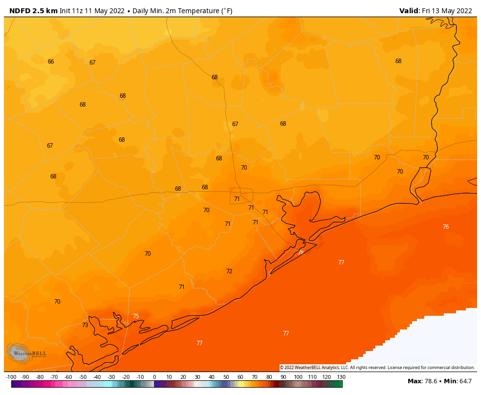
Lows Friday morning will be quite chilly. (Weather Bell)

Friday

This will be a day a lot like Thursday, with ample sunshine, highs in the 70s, and a persistent northerly wind. Clear skies and dying winds should help Friday night’s lows once again fall to around 50 degrees in Houston, with cooler conditions for outlying areas.

Saturday

Winds will turn easterly on Saturday, at 10 to 15 mph, and this will help highs nudge into the lower 80s. Skies should still be sunny, however, and the air will remain fairly dry. Lows Saturday night will only drop into the low 60s for most areas.

Sunday

As moisture levels continue to rise, we should see the development of some clouds on Sunday, with highs probably slotting into the low 80s. Overnight temperatures may not drop below 70 degrees in the city on Sunday night.

Houston will see two more cool nights before things warm up. (Weather Bell)

Next week

The forecast for next week remains somewhat muddled. What I think we can count on is fair amount of clouds, and highs in the 80s, with a decent amount of humidity. There will be some rain chances by Monday and Tuesday, but right now there’s no definitive spark for storms or widespread showers, although that could change. Some kind of front is likely to move through later in the week, but there’s no certainty on how much oomph it will bring in terms of dry air and cooling. So if you like your nights chilly, enjoy the next two.

Windy for awhile, and an early look at an Easter forecast

Good morning. Houston experienced its first 90-degree day of the year on Tuesday. But while it was undoubtedly hot outside, dewpoints were reasonably low—in the mid-60s—so for Houston it was a somewhat dry heat. A front moving through the region today will sweep the heat and moisture away for a bit. But not forever, of course, as we’re now mere weeks away from the onset of summer-like conditions. In today’s post I’ll also take an early look at an Easter forecast.

Wednesday

Temperatures are generally in the low 70s this morning, with some patchy fog. This will lift as temperatures rise. There should be no rain with the front, but the wind shift should be noticeable along with a rapid influx of drier air. The front will will likely reach areas such as Katy and The Woodlands by around 11 am, central Houston around noon, and push off the coast by early afternoon. In the wake of the front, this afternoon, expect temperatures to settle at about 80 degrees with winds gusting to 25 or possibly even 30 mph in some locations. Lows tonight will drop into the mid-50s.

Wind gust forecast for 5 pm CT from the European model. (Weather Bell)

Thursday and Friday

These will be a pair of sunny days, with highs in the upper 70s, and lows of about 50 degrees. The air will also be quite dry, with dewpoints dropping to about 30 degrees. This is probably the driest air we will see until at least October, if I had to guess. Both Thursday and Friday will be breezy, with gusts out of the north up to 25 mph, to support this influx of drier air.

Low temperature forecast for Friday morning. (Weather Bell)

Saturday, Sunday, and early next week

Saturday looks pretty great. Winds will shift to come from the southeast, but they should drop back some to 10 or 15 mph. Highs will reach about 80 degrees beneath mostly sunny skies. As this onshore flow progresses, winds will probably pick up, perhaps gusting to 25 or even higher from the south by Sunday. As a result, Sunday looks to be more humid, with highs around 80 degrees, and the development of some clouds due to increasing moisture levels. Still I don’t anticipate any rainfall.

With more moisture in the atmosphere, we may start to see some scattered showers on Monday or Tuesday of next week. Whether it actually rains, and how much, will depend on the evolution of atmospheric disturbances. We shall see. Highs for most of next week should slot somewhere in the 80s, with the possibility of a weak front arriving on Wednesday to cool things down a little bit.

Easter Sunday

So what does all this mean for April 17, Easter Sunday? Right now there’s no clear signal, but the majority of the model guidance suggests the region will be warming up late next week. My best guess is a high somewhere between 80 and 85 degrees, with partly sunny skies. It’s far too early to say anything definitive about rainfall, but at least there’s no indication right now of particularly heavy rainfall or something crazy like that.