Good Saturday morning. Ida is strengthening steadily this morning as it moves into the heart of the exceptionally warm Gulf waters between Cuba and Louisiana. Not much has changed since yesterday in terms of the forecast track or, unfortunately, forecast intensity.
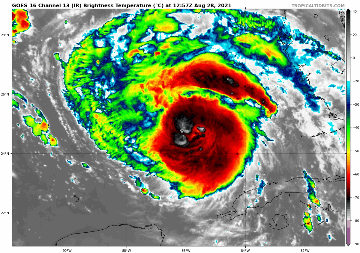
Hurricane Ida’s eye has emerged this morning, indicating that intensification continues. (Tropical Tidbits)
If you look at the satellite loop above, Hurricane Ida’s eye is emerging, indicated by the little green “dot” in the middle of the storm, an indication that the system is strengthening.
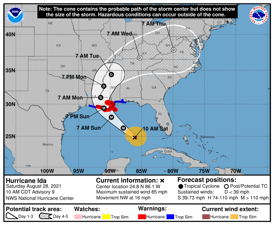
Unfortunately, very little has changed since yesterday. The track is essentially unchanged, with the National Hurricane Center predicting a track toward Morgan City, LA, with a little wiggle room on either side.
The NHC forecast has been dialed in for some time now, and a landfall near Morgan City, LA seems most likely on Sunday afternoon or evening as a powerful category 4 hurricane. (NOAA)
The intensity forecast is mostly unchanged as well, with modeling implying that a major (category 3 or 4) hurricane is almost certainly going to be what makes landfall. At this point, folks along the eastern Louisiana coast should be preparing for significant hurricane impacts.
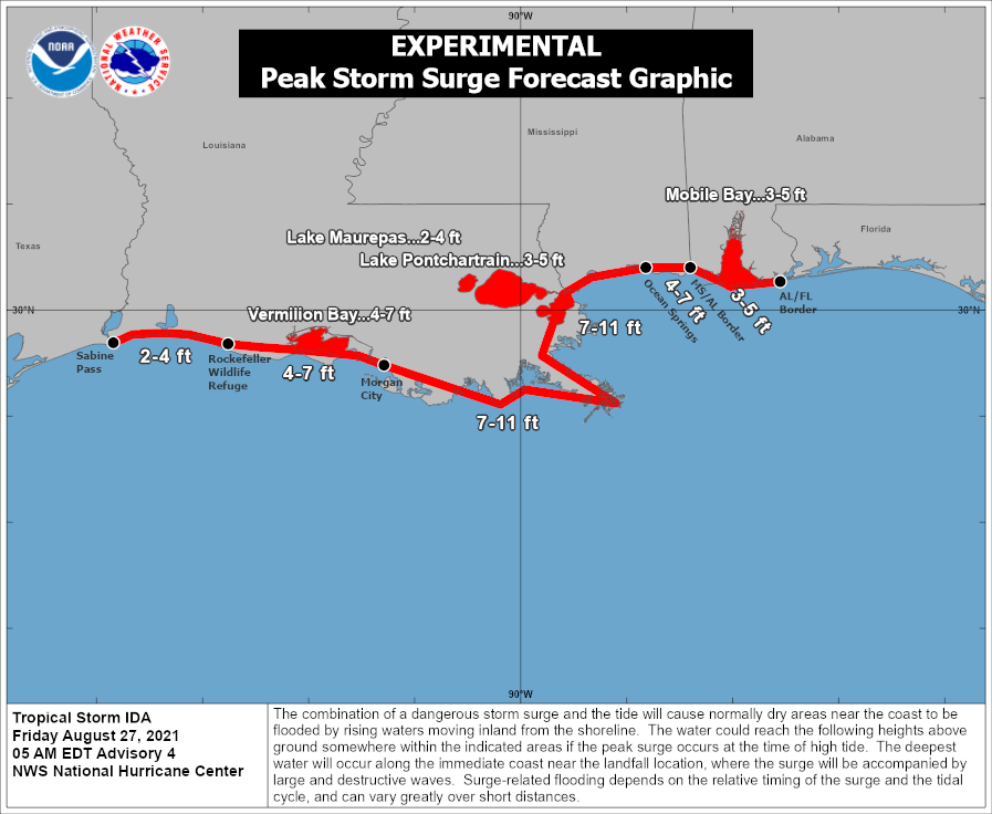
Storm surge values are mostly unchanged today too,
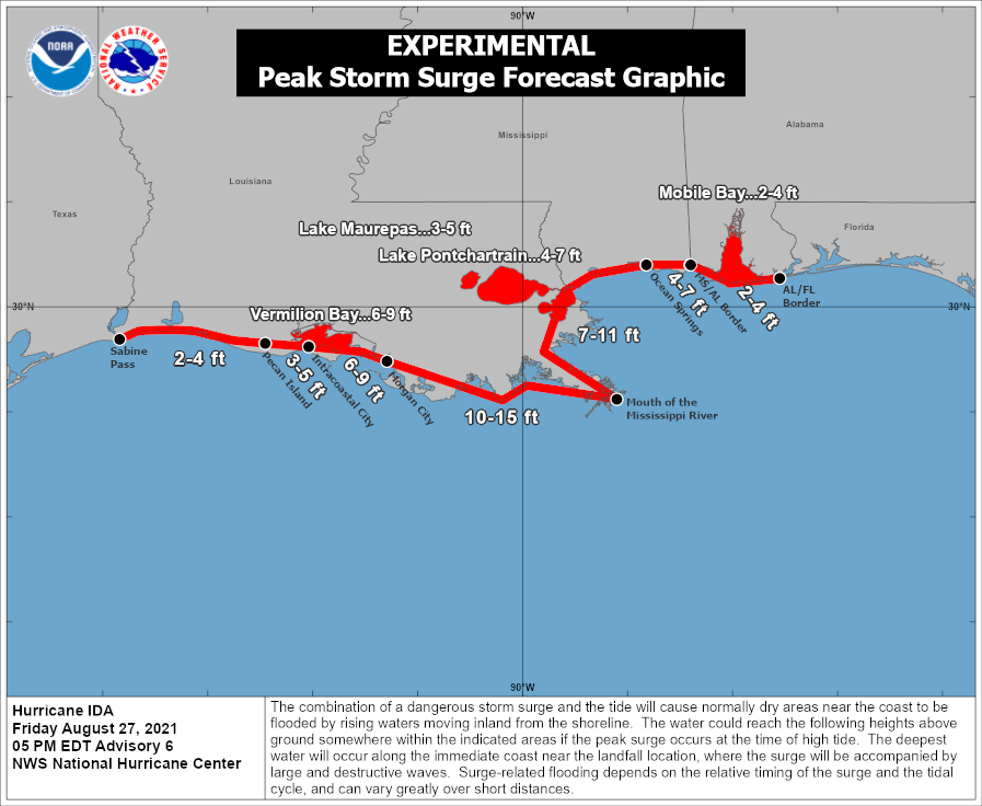
Significant storm surge of 10 to 15 feet above ground will be possible if Ida makes landfall around high tide tomorrow in eastern Louisiana. That much water can be expected outside of levee protected areas. (NOAA)
A significant 10 to 15 foot surge is possible between Morgan City, Grand Isle, and the mouth of the Mississippi River. Slightly lower values can be expected just southeast of New Orleans. It is tempting to compare Ida with Katrina, but there are a number of differences from track to intensity to size. For New Orleans, in Katrina, winds were out of the east and then out of the north. With Ida, winds will be out of the southeast most of the time, which means different impacts this time around. Hopefully far less severe, particularly given the distance of landfall from the city. But it’s obviously much too close for comfort.
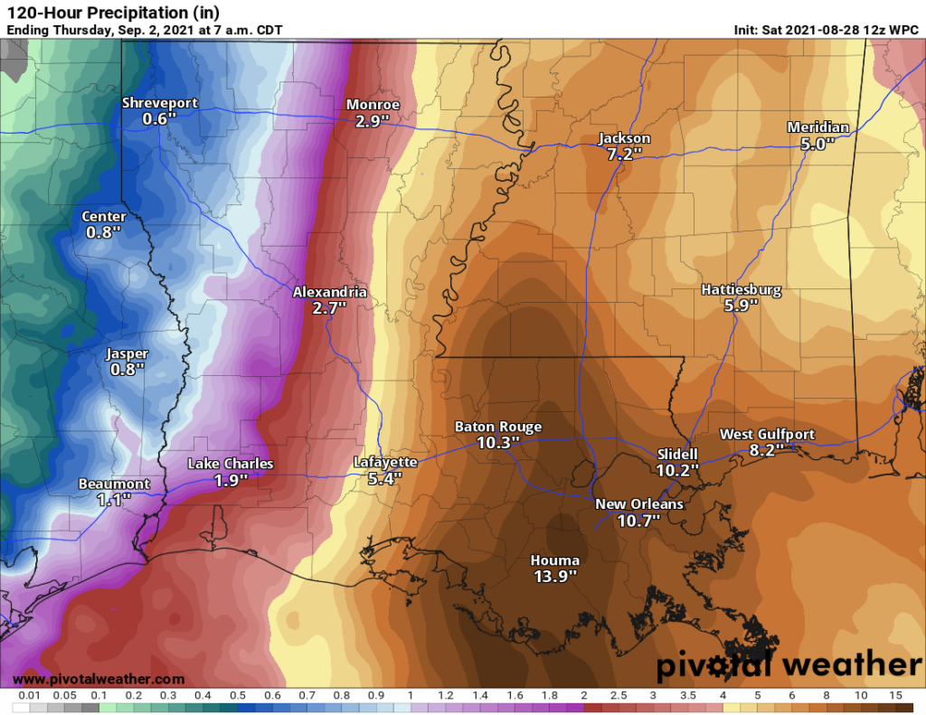
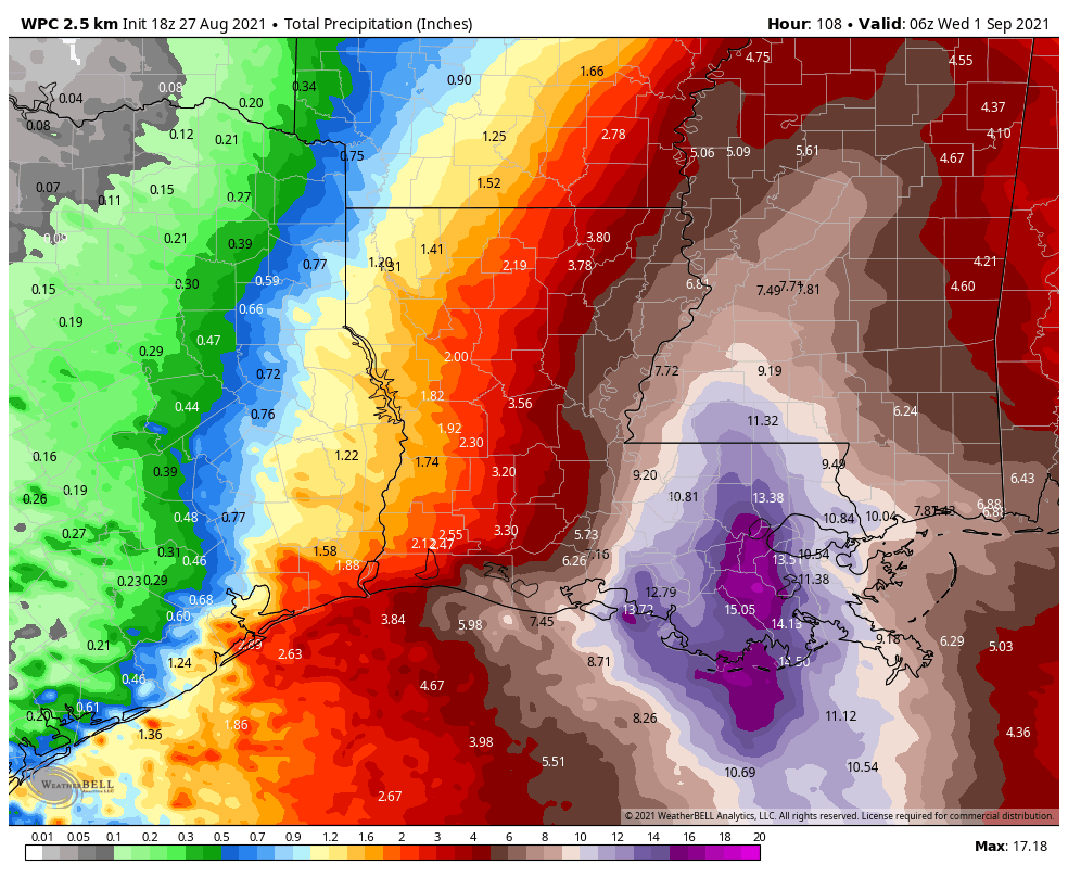
In addition to the wind and surge, as we’ve noted Ida will have a ton of moisture as it comes ashore. This will lead to significant rainfall and probably freshwater flooding issues all across eastern Louisiana and Mississippi.
Significant flooding rainfall will be likely across most of eastern Louisiana and much of Mississippi as Ida comes inland. As much as 10 to 15 inches of rain is possible between Baton Rouge and New Orleans. (Pivotal Weather)
Maximum totals of 10 to 15 inches will be possible along and east of where Ida comes ashore, leading to significant flash flooding and river and bayou flooding in eastern Louisiana. Significant flash flooding issues will likely continue as Ida lifts north into Mississippi as well.
All in all, Ida will be a very, very serious storm for our neighbors to the east, and our thoughts are with them.
Local update
Just a quick local update for the weekend. Scattered showers or thunderstorms will be possible today. We expect coverage to diminish tomorrow, so less chance of rain. And even less chance of rain is with us on Monday. Look for temperatures in the low-90s today and mid-90s tomorrow. Mid, if not upper-90s will be possible on Monday. Winds here should be out of the north or west after tomorrow and be no worse than 10 to 15 mph or so. Some minor runup is possible along the coast with rough surf and strong rip currents, so exercise caution if you’ll be swimming tomorrow or Monday.
Barring any significant changes with Ida, Eric will have our next update on Sunday morning.
Hurricane Ida has strengthened significantly today, going from barely tropical storm status to a Category 1 hurricane with 80-mph sustained winds. Unfortunately, there is little to inhibit further strengthening this weekend. After Ida moves across Cuba tonight, the combination of low wind shear, a moist atmosphere, and blazing hot Gulf of Mexico sea temperatures are ideal for rapid intensification. For this reason, the latest National Hurricane Center forecast brings Ida to a Category 4 major hurricane before landfall along the central Louisiana coast on Sunday afternoon. Confidence is very high in this track.
4pm CT National Hurricane Center track forecast for Ida.
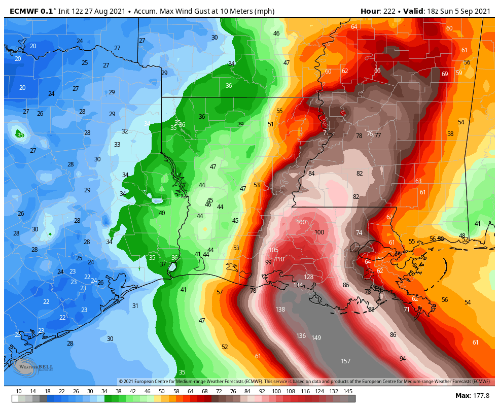
This post will address what such a storm will actually mean for people on the ground. First up is a forecast for “wind gusts.” This is different than sustained winds, which are how forecaster define the intensity of a storm. But gusts are an appropriate measure of maximum winds. Here’s a forecast for the swath of highest gusts from Ida. It is not gospel, but it offers a good approximation of what to expect, where. There will be major structure damage and widespread power outages.
Swath of maximum wind gusts forecast by the European model. (Weather Bell)
The next threat from a hurricane like Ida is storm surge. The graphic below from the National Hurricane Center is the best estimate for the combination of surge and tide above normal water levels. Ida will bring a dangerous storm surge to the Mississippi River delta area, and parts of New Orleans not behind the levee system.
The final major threat from a hurricane like Ida is inland rainfall. The storm is going to keep moving, but it will slow a little as it approaches the coast and moves inland. This should allow for some areas of southeastern Louisiana to experience 10 to 20 inches of rainfall, which will be falling on top of a significant storm surge. These are dangerous amounts of water for unprotected areas.
Inland rainfall expectations from Ida for now through Tuesday. (Weather Bell)
There is not much of a silver lining for this storm, which is set up to deliver a gut punch to the state of Louisiana. The only thing we can offer is that the western part of the state—including Lake Charles—that was pummeled during the 2020 hurricane season should escape the worst of Ida. After this storm moves away from New Orleans later on Monday and Tuesday it will be time to help. That is something the generous people of Houston are very good at.
Matt or I will have an update on Saturday before noon.
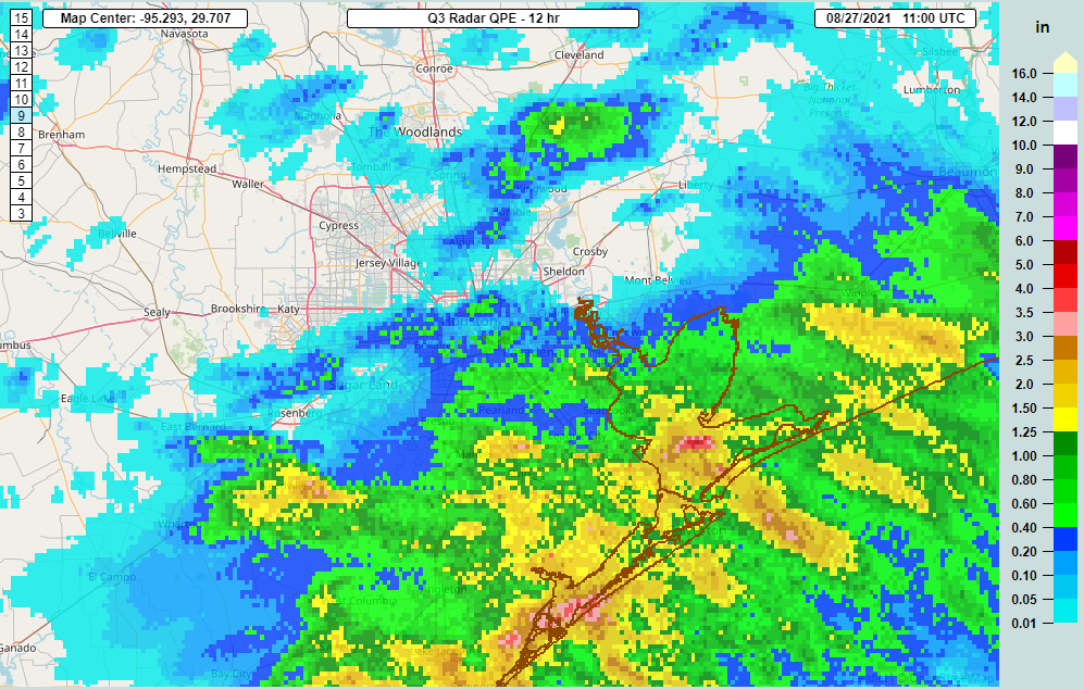
Good morning. Some locally heavy rainfall since Thursday evening has added up to over an inch between La Porte and Seabrook and 2 to 3 inches or even a bit more right on the Brazoria/Galveston County line between Alvin and Pearland.
Radar estimated rainfall totals from 6 PM Thursday through 6 AM Friday shows the heaviest rainfall occurred along the coast, with just spotty rains farther inland. (NOAA NSSL)
We aren’t done with rain just yet.
Today
This morning is starting with rain up and down the coast and little to nothing inland. This is not related to Tropical Storm Ida, but rather what we call an “inverted trough” along the coast, not something that’s uncommon. That area will move inland today, and while the current coastal rains should gradually fizzle, with daytime heating, some scattered showers and storms will pop up inland through this afternoon. Some inland places may not see rain, but those that do could see locally heavy rain.
Radar as of 6:15 AM Friday shows rain up and down the coast and offshore, while inland areas are mostly dry. Rain should move inland and weaken a bit today, but new scattered showers or storms will develop in spots. (RadarScope)
Temperatures should still manage to get into the upper-80s to low-90s today, though it may be a couple degrees cooler south and east of the city, where clouds and rain will linger for a few hours this morning.
Weekend
Saturday should see additional support for scattered showers and storms across the area. The day should not be a washout, but you will have to dodge some raindrops or thunder in parts of the area. We may see the rain follow a similar pattern to today, with more along the coast in the overnight and early morning, spreading inland during the daytime.
We begin to feel Ida’s influence on Sunday. While no direct impacts are expected in Houston, the subsidence (sinking, drier air) created on the west side of a broader hurricane circulation tends to reduce rain chances and can lead to some hotter weather. Sunday should still see at least a few isolated to scattered showers, but coverage will probably be considerably less than today or Saturday.
Look for high temperatures in the upper-80s to low-90s on Saturday and then low to mid-90s on Sunday. Morning lows should be in the 70s. Winds this weekend will shift from the east to more from the north or northeast and should remain in the 5 to 15 mph range. They may increase a bit more offshore into Monday. Impacts from Ida will be limited to some rough surf building on Sunday. Importantly, if you’ll be at the beach, rip currents are expected to strengthen considerably on Sunday, so please use caution if you’re headed into the water.
Next week
Ida’s drier side influence may stay with us Monday, and high pressure should build in for Monday and Tuesday. This should keep rain chances quite low to start the week. Expect sunshine, a few clouds and mid to upper-90s. More typical rain chances may return for the middle and end of next week. It’s too early to speculate much on if we will have to watch another tropical system later next week or weekend. But there aren’t really any credible, consistent model solutions that point to that happening right now. We’ll continue to watch.
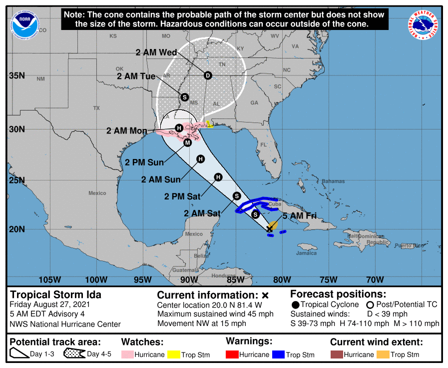
Tropical Storm Ida
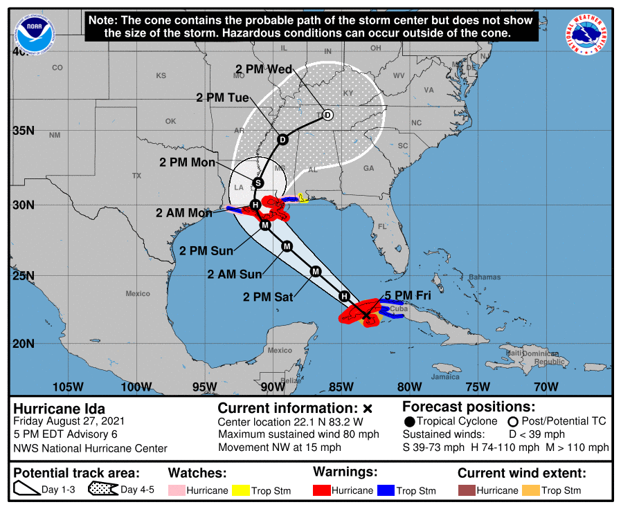
Ida is slowly getting itself organized this morning near the Cayman Islands. It is expected to pass over western Cuba tonight, and then resume basically a beeline northwest into the Louisiana coast by Sunday night. The National Hurricane Center is now forecasting a major hurricane to make landfall on the central or eastern Louisiana coast.
The 5 AM advisory for Ida forecasts it to become a major hurricane as it makes landfall in Louisiana. (NOAA)
Ida is still dealing with a bit of shear and disorganization this morning, but it’s definitely strengthening a bit. With all this in mind, there could be some further track nudges east or west. The NHC forecast has trended more east in general, but it’s held a pretty steady landfall point. But given that track error is still typically 100 miles or so, there is a little wiggle room here.
But for us in Houston that should not make much difference in what we experience unless perhaps we’re sitting in a boat offshore. With 6 to 10 foot waves expected offshore, this could lead to a little run up or minor coastal flooding in the usual coastal trouble spots. A storm that comes a little more west could yield a little more runup and vice versa. But for the most part no serious issues are expected in our area. Beaumont/Port Arthur and Lake Charles still look good for now, but those areas should continue to monitor trends through the day, just in case the western core of the storm drifts a little closer due to track adjustments. But direct, full fledged impacts would be highly unlikely given the track forecast, model forecasts, and historical error.
Unfortunately for folks in central or eastern Louisiana, the same cannot be said, and in addition to wind and rain, storm surge will be an issue as well. The current peak surge forecast (water level above ground if it occurs at high tide) is 7 to 11 feet across most of eastern Louisiana.
Significant storm surge is expected in eastern Louisiana, as well as on parts of the Mississippi and Alabama coasts. (NOAA)
I know people likely have concerns for eastern Louisiana seeing this. There are protections in place there that should be able to help mitigate surge flooding due to a storm of this magnitude in populated areas. For eastern Louisiana, these surge values are forecast to be a few feet higher than experienced during Hurricane Zeta last autumn, which tracked just east of where Ida should go. Ida will be coming in out of the southeast though, not the due south or southwest like Zeta, so there are further differences there. Whatever the case, folks in that region need to prepare for impacts from a major hurricane Sunday into Monday morning.
Eric will have another update for you no later than 5 P.M. this evening.
Good afternoon! There has not been much change in weather modeling since this morning, which is a good thing for Houston, as that means we expect, with fairly high confidence that Tropical Storm Ida will stay well east of the Houston area, causing only some fringe impacts along the coast. Good news for Houston means bad news for someone else unfortunately, and Louisiana looks to see the core of impacts from Ida. The Gulf has been exceptionally unforgiving in recent years.
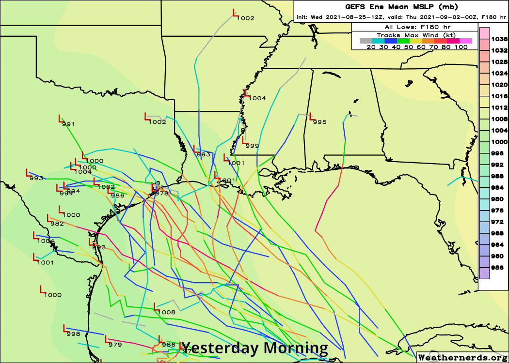
Right off the bat I just want to show you how far we have come in terms of track forecast confidence in the last 24 hours. Here is an animation showing yesterday’s ensemble “spread” from the GFS ensemble. Just to quickly recap: The ensemble consists of over 30 individual model runs, each one tweaked just a little at initialization (hour 0) and then run like any other model out over two weeks. The advantage of using an ensemble is that you get a wider range of possible outcomes, which can guide your forecasting, and it can also perhaps highlight areas of higher confidence. In this case, over a 24 hour period, the ensemble went from a wide, unruly range of outcomes to a fairly tightly packed group of outcomes.
The spread among the GFS ensemble members has dramatically narrowed in just 24 hours, as confidence has increased in a storm track generally toward central or eastern Louisiana. (Weathernerds.org)
That helps boost our confidence. As you can see there, is still a bit of a range of possible outcomes, but instead of ranging from Mexico to Florida, they now primarily range from the Texas/Louisiana border to the Mississippi/Alabama border. And virtually all of these outcomes spare Houston any impacts.
Hurricane models are also in good agreement on this, so we’ve seen our confidence in a miss for Houston grow exponentially in the last 12 to 18 hours or so.
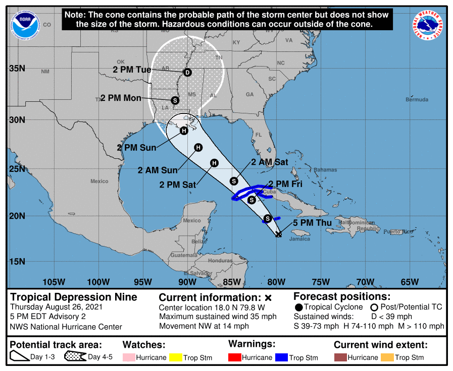
Here is the official National Hurricane Center forecast track for (now) Tropical Storm Ida.
The official NHC forecast for Tropical Depression 9 (now Ida) brings it to the Louisiana coast as a borderline major hurricane on Sunday. (NOAA)
They are explicitly bringing it close to major hurricane status (110 mph is the maximum forecast at this time) as it makes landfall on the Louisiana coast Sunday. There is still some uncertainty around timing and exact intensity, but the takeaway message from the NHC discussion and forecast is that a strengthening hurricane is likely to make landfall in central or eastern Louisiana on Sunday night.
I know some folks are concerned about the Lake Charles area after last year. While they are not out of the woods yet, most model data and this forecast implies that impacts to Lake Charles would be fringe and mostly limited to just some outer bands with a few gusty thunderstorms. The Beaumont and Port Arthur areas should expect similar conditions.
Locally, we will want to keep an eye on tides, rip currents, and rough surf this weekend in the Gulf. If you’re planning a beach weekend, keep the rip current risk in mind, as swells from the storm approach Sunday into Monday. I will have some more on that in the morning.
As far as rainfall, we should not see any direct rainfall from the storm here in Houston. The heaviest rain appears as though it will fall in central and eastern Louisiana and Mississippi.
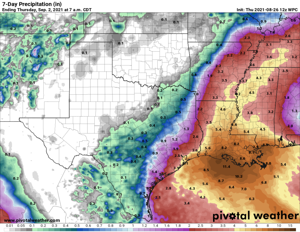
Rainfall from Ida will be heaviest along and east of the track, which should yield the highest totals in central and eastern Louisiana, as well as perhaps in Mississippi. Forecast totals may come down some in the Lake Charles and Beaumont areas, although locally heavy rain will occur with unrelated scattered storms tonight through Saturday. (Pivotal Weather)
Some of the storms we get the next few days in Houston, unrelated to Ida, could be a bit heavy, including some tonight. Storms will be moving east to west across the area, which isn’t terribly common, but again, this is not related to the tropical system. Eric’s morning post still looks good for tonight and tomorrow if you need some more details.
Beyond that, we can exhale in Houston for now it seems. There will be other tropical systems to watch over the next 2 to 3 weeks, but none of them looks like a specific threat to our area at this time. Surely that could change, but that is all we can say right now. In the meantime, our thoughts are with our neighbors to the east who will likely be forced to endure yet another considerable tropical system.