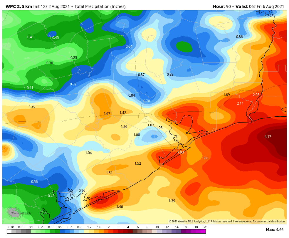
The August cool front has effectively moved down to the coast, and it has shoved most of the moisture offshore. As a result we should see a pair of pretty fine days—for August, of course—before the front washes out. Rain chances will increase somewhat by Friday but overall I still expect the weekend to be mostly sunny for most of us.
Wednesday
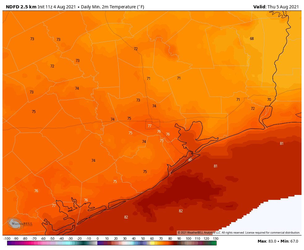
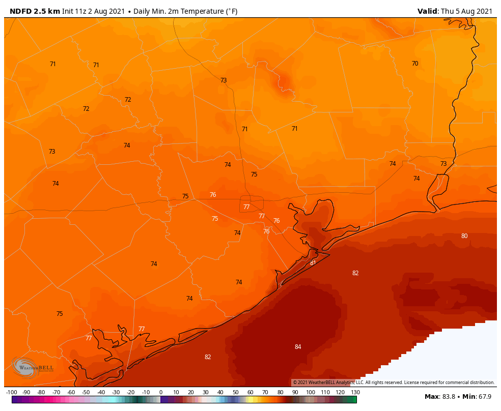
Light northerly winds are helping to bring moderately drier air into the region today, and this will help to limit rain chances. For inland areas, north of Interstate 10, rain chances are probably 10 percent or less. But closer to the coast, especially for areas such as Fort Bend, Brazoria, and Wharton counties, we could see storms pulse up this afternoon with daytime heating. Otherwise, highs today should be around 90 degrees for much of the area, with partly sunny skies. Overnight lows will probably be the lowest of the week, with some far inland areas perhaps seeing the upper 60s to low 70s. It will be a good evening for a walk or to otherwise get outdoors.
Thursday morning lows will be pleasant for August! (Weather Bell)
Thursday
This should be another reasonably nice August day, with mostly sunny skies and highs in the low 90s. Rain chances should be below 20 percent for the entire region.
Friday
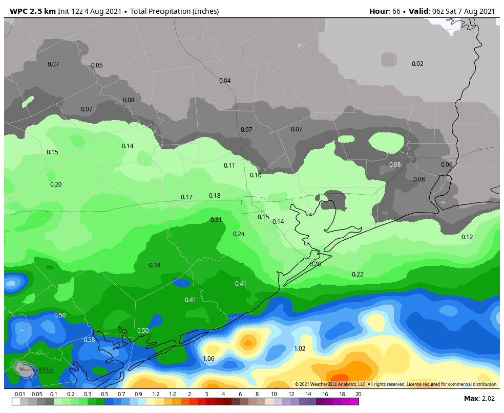
As the onshore flow returns, so too will humidity and possibly some better rain coverage. Highs Friday will be in the mid-90s with mostly sunny skies. There probably is about a 40 percent chance of afternoon showers flaring up.
NOAA rain accumulation forecast for now through Friday. (Weather Bell)
Saturday and Sunday
There are still some questions about the weekend forecast, but my best guess at this point is hot and sunny weather, with highs in the mid-90s. Depending on the overall setup of the atmosphere we might see about a one-in-three chance of afternoon showers, or it could be lower than that. I hope to have that better nailed down for you tomorrow.
Next week
As we get deeper into August, it looks as though we’ll see fairly typical August-like weather next week. This means highs generally in the mid-90s, lots of sunshine, and the potential for scattered afternoon showers along the sea breeze.
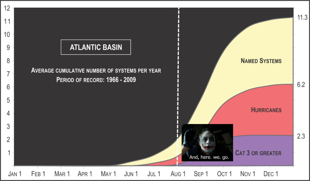
Lately, I’ve enjoyed opening these posts with a comparison to where we were in 2020 at this time. By August 3rd of last year, we were watching Hurricane Isaias approach the East Coast, and Tropical Depression 10 had recently dissipated. We were actually heading into a lull period, as Josephine would not form for over a week. This year, we remain stuck on Elsa as our last storm. It was great to have a quiet July, but as Eric noted yesterday, we are merely through the easy third of hurricane season. The most likely time for storm impacts here historically is the next 6 to 8 weeks. Of the major hurricanes to strike our region through history (Cat 3+), virtually all have occurred in August or September. The 1909 Velasco Hurricane was an exception, as it occurred in July. So, now is the time to start watching seriously.
Tropical outlook in a sentence
While the noise is going to increase and we are likely to begin to find some disturbances to monitor in the Atlantic over the next week or so, none appear to be overly serious candidates to end up in the Gulf at this time.
Current Atlantic disturbance
The current disturbance outlined by the National Hurricane Center as having a 10 percent chance of developing over the next 5 days is not really much of a concern for us at this point in time. I think we need a little time to start priming the basin, so while this one may make a little noise in the next few days, it seems unlikely to sustain itself.
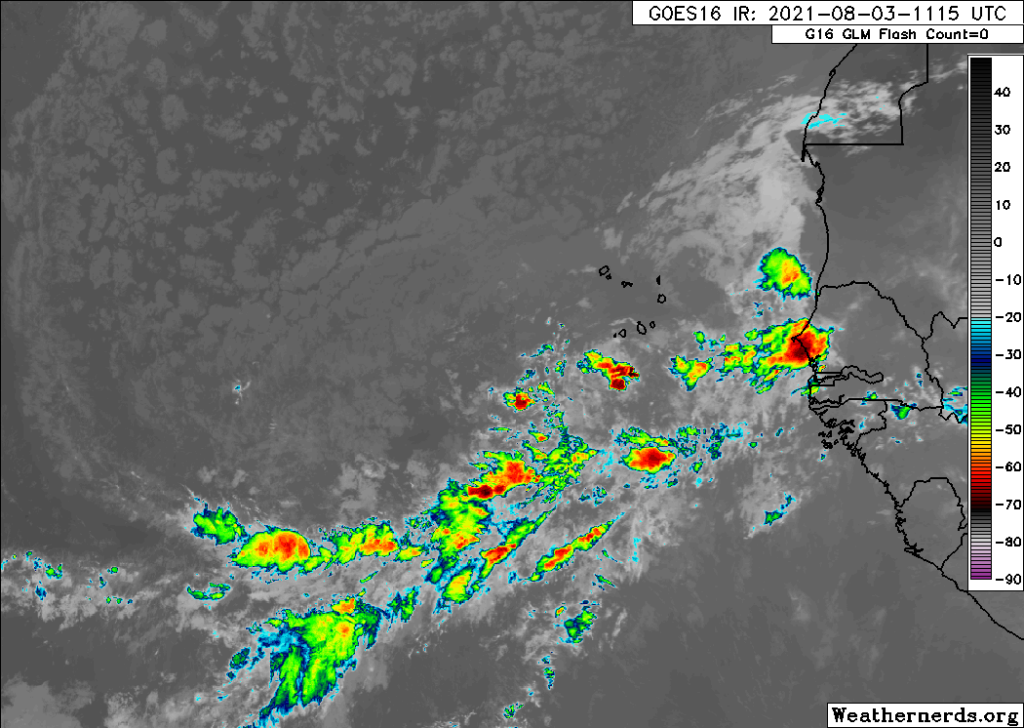
A satellite image of the eastern Atlantic off Africa from earlier this morning shows areas of thunderstorm activity, but a distinct lack of any organization (Weathernerds.org)
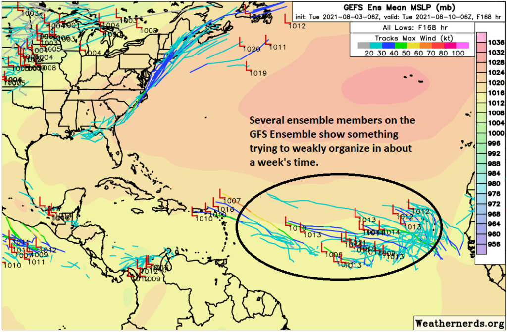
Most ensemble members of the major models have this thing flailing around for 72 to 96 hours and not doing much. Thereafter, things could change, but that could also be courtesy of another disturbance. Which leads us to…
Next in line
In general, it’s a little noisy in the eastern Atlantic right now, so it’s tough to separate signal from that noise at this early stage in the game, even in modeling. But either the disturbance currently outlined by the NHC or, more likely, another one should begin to try and coalesce from the mess in about 5 to 7 days in the open Atlantic.
A number of ensemble members from the GFS (less from the Euro) show some weak development from the morass of storminess in the Atlantic in about a week. (Weathernerds.org)
At this early juncture, trying to hash out what this does is very uncertain. Right now, the vast majority of ensemble members either kill this disturbance off or have it recurving over the open Atlantic. Few, if any are taking it to the Gulf. We have about 80 different ensemble members between the GFS & European ensemble models, which provides a nice, wide spread of plausible outcomes. But by no means is it a guarantee that we’ll see either of those scenarios (a recurve or a dissipation) play out. But it seems to be the favored outcome at least at this time.
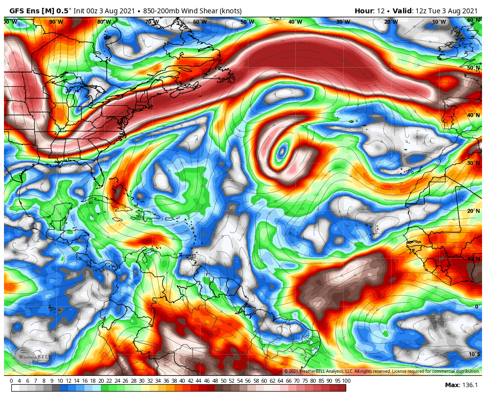
But, let’s focus on the overall pattern as forecast by the GFS and European ensemble models beginning around day 10 to see if there are any clues. Let me start by showing you wind shear. Both the GFS and European ensembles show a fair amount of wind shear setup over the Central Atlantic — for days.
The GFS ensemble forecast of wind shear (brighter colors = more wind shear = less favorable conditions for development) shows a band of pretty persistent shear extending from the Caribbean across the Central Atlantic over the next 2 weeks, which will act as a slight check on a development in the deep Atlantic. Closer to home, shear intensity is a bit more variable, however. (Weather Bell)
This makes sense at a high level, and this seems to lend some credibility to the idea that whatever does develop may have some challenges in front of it as it moves across the ocean. Closer to home, the shear relaxes a bit, but until we see a disturbance heading that way, it’s not too concerning.
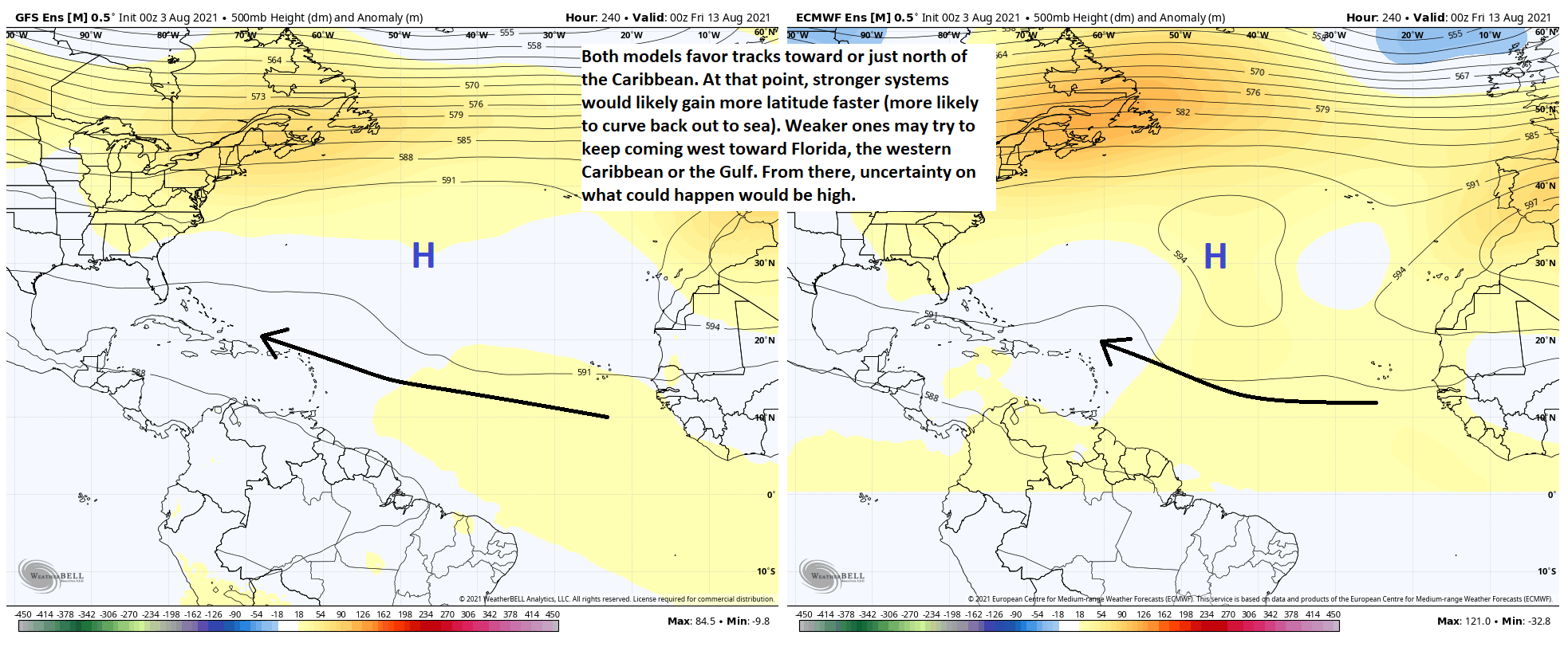
So where will it track? Great question. If we compare the GFS ensemble & European ensemble forecast maps at the 500 mb level (about 20,000 feet overhead) on day 10, I’ve annotated the maps with some notes.
Click to enlarge. The GFS ensemble mean (L) and the Euro ensemble mean (R) both favor a broad track west over the next 10 days toward or just north of the Lesser Antilles. From there, stronger disturbances would likely lift north (no Gulf threat), but weaker ones could come farther west. Uncertainty on what happens to them beyond this point is high, but at least sitting here today, there is no meaningful model guidance suggesting a serious threat. (Weather Bell)
There is a fairly strong high pressure in the upper atmosphere over the ocean. It’s not overly strong, but it may be enough to allow a weaker system to get kicked westward a little farther than perhaps models currently say. The general rule of thumb with Atlantic and Caribbean systems is that a stronger storm will gain latitude faster and a weaker disturbance will be subject to being “bullied” by high pressure and shoved west a little farther. Of course, if this fails to coalesce into a system at all, the point is moot and all the better.
So at this point it’s nothing to worry about because even through day 15, hardly any reliable model guidance has anything of note looking like it will enter the Gulf. But, given the calendar and trajectory of the disturbances out there, Eric and I will be keeping tabs on things, though not talking much unless it becomes apparent that we’re going to have something legitimate to watch.
Beyond this day 10+ stuff in the Atlantic, there will likely be continued background signal support for further disturbances through August 15th to the 25th or so. There may be some signs of less supportive conditions arriving later in the month, and when you factor in some lag time, that could start to assert itself in September. But I’d rather not get my hopes too high just yet. This concerns the “velocity potential” maps we discussed last week. A colleague and PhD candidate at Florida State, Jake Carstens, wrote a great piece on those maps and how they’ve been used to help sniff out this upcoming active period. He did a great job explaining how those maps work and it’s worth your time if you’d like to really get more into some serious meteorological analysis.
Anyway, enough for this week. We’ll see where things stand when we check back in on the tropics next week!
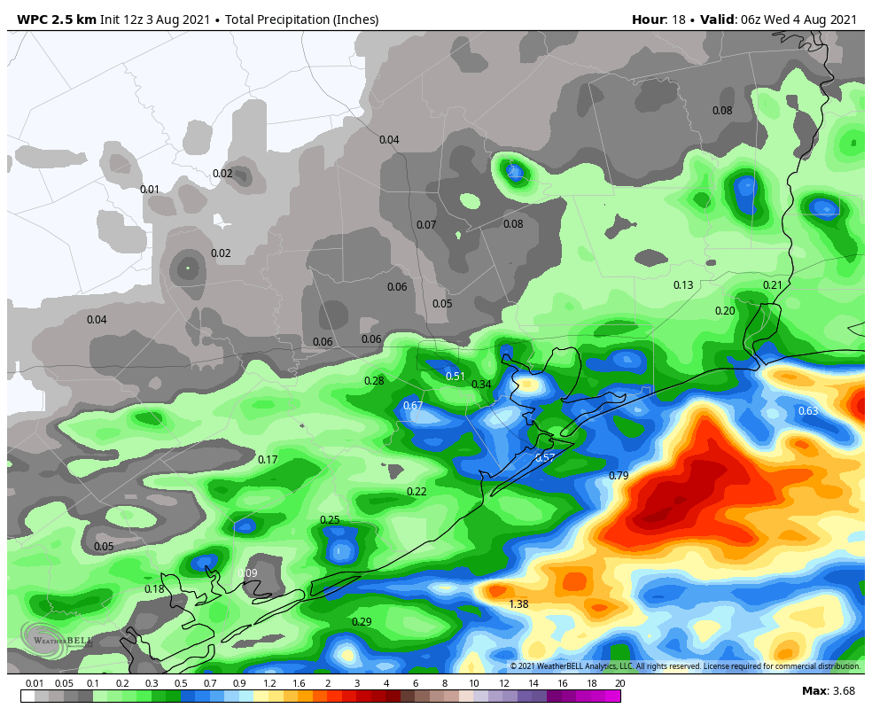
A “front” has moved into Houston, south of Interstate 10, and should continue to creep toward the coast today. This will bring healthy rain chances to the region again today, especially if you live closer to the Gulf of Mexico. Some slightly drier air should follow on Wednesday, although the changes will be fairly subtle. Even so, by August standards, conditions will be pretty reasonable this week in Houston. We’ll heat back up this weekend.
NOAA rain accumulation forecast for Tuesday and Tuesday night. (Weather Bell)
Tuesday
Most shower activity at sunrise this morning is along the coast, near places like Lake Jackson and Jamaica Beach. These storms should wane over the next couple of hours before daytime heating initiates a new round of storms this afternoon. If you live south of Interstate 10, rain chances will be about 50 percent, with 30 percent chances north of the freeway. These showers may be briefly intense, with lightning, as they move generally from west to east. Highs, otherwise, will be around 90 degrees with winds coming out of the north.
Wednesday
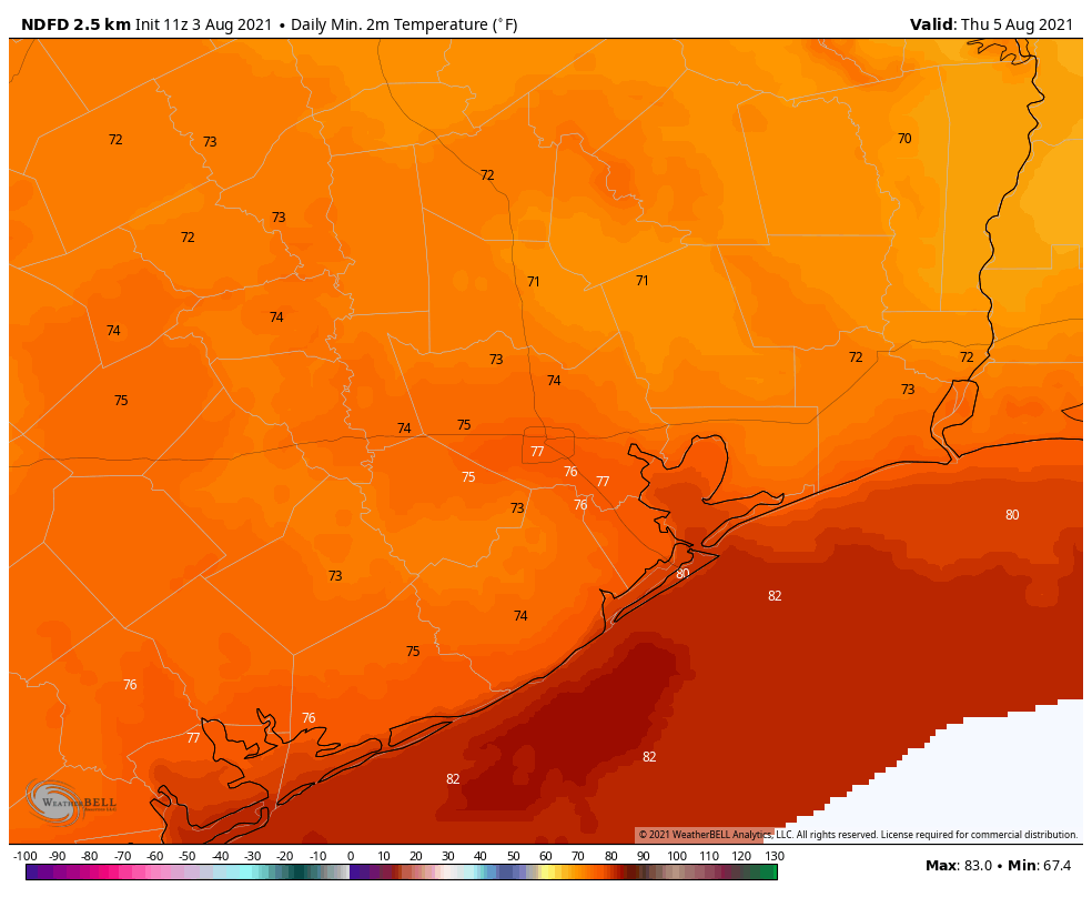
Storms may fire up again early on Wednesday morning, primarily along the coast and offshore. Later in the day storms will probably be rather scattered across the area. Some sunshine is possible, with highs in the low 90s. Overnight lows on Wednesday night may drop to about 70 degrees for inland areas, and with a smidge of drier air this won’t be half bad.
Low temperature forecast for Thursday morning. (Weather Bell)
Thursday
This should be another reasonably nice day, with scattered afternoon showers and highs in the low 90s. Again, the humidity will be high, but not Houston high.
Friday, Saturday, and Sunday
By Friday we should begin to slide back into more typical Houston summertime weather over the weekend. We’ll still have a chance for some passing, afternoon showers and thunderstorms. But for the most part I expect these days will bring mostly sunny skies and highs in the mid-90s. Oh, and plenty of humidity of course.
Sunday was August 1, which means that a third of the Atlantic hurricane season is now in the books. While that’s a good thing, the reality is that the vast majority of hurricane activity, historically, occurs after August 1st. And for the state of Texas, the odds of a hurricane strike after October 1st are remote. So for us, the next two months really matter. This is when you should have your hurricane plans finalized, and preparations made.
Graphic showing a majority of Atlantic hurricane activity occurs after August 1. (National Hurricane Center)
In terms of a near-term tropical forecast, Matt will have more in our weekly update on Tuesday. However, we’re definitely seeing signs that activity in the “main development region” between Africa and the Caribbean Sea will start to heat up in a week or so. And after that point we’ll likely be closely watching tropical activity for awhile.
Monday
Remarkably, the main discussion point for today, the second day of August, will be a cool front approaching the area. This “front” won’t bring too much cool or dry air, but it will generate enough of a disturbance in the atmosphere to provoke rising air and a good possibility of showers and thunderstorms. Most of the area should see partly sunny skies this morning, with increasing clouds late this morning to go along with rising rain chances.
I think we’ll see a round of showers that will hit about half of the region this afternoon, perhaps a break this evening, and then another round of storms overnight that will probably hit a majority of the Houston area. Accumulations for most will be on the order of 0.5 to 1.0 inch, but some few areas may pick up 3 or more inches. We’re not expecting anything more than low-lying street flooding, at worst. For the most part we should see highs in the low 90s.
NOAA rain accumulation forecast for now through Thursday. (Weather Bell)
Tuesday
As the front gets hung up along the coast on Tuesday, we should see scattered showers again although probably not with the intensity some areas see Monday and Monday night. Otherwise we expect partly sunny skies with highs in the low 90s. As far as cooling goes, overnight lows should drop into the mid-70s for much of the region, which isn’t terrible for August.
Wednesday and Thursday
The weather these days will depend on whether the front shoves all the way offshore, but if it does I expect a pair of reasonably pleasant August days, with highs in the low 90s, slightly lower humidity, and scattered to isolated rain chances. Lows will be in the 70s.
Thursday morning’s lows should be the coolest of the week for most locations. (Weather Bell)
Friday, Saturday, and Sunday
The end of the week looks to bring mostly sunny weather to the region, with increasing humidity. Highs will likely be in the neighborhood of the mid-90s. At this point it looks like the atmosphere will be supportive of some scattered showers and thunderstorms during the afternoon hours with daytime heating. For the most part, however, this should be a pretty classic August weekend in Houston with heat and humidity.