Good morning. This will be a fairly wet week, with more clouds than sunshine. Rain chances will peak today and Tuesday, before a bit of a lull, with healthy rain chances returning for the Fourth of July weekend. Will the holiday be a total washout? Probably not, but it’s too early to tell whether it will rain during our much anticipated fireworks’ shows.
Monday
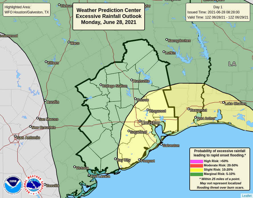
Pretty much everyone in the Houston region is guaranteed to see rain today as an upper-level low pressure system combines with a very moist atmosphere. But whereas some regions see intermittent light showers, others will see downpours. So far storms have moved steadily from southeast to northwest, and this motion has limited rainfall rates to 1 to 2 inches per hour as storms move through. Our primary concern is that, in a few areas, these storms may grind to a halt.
Overall, I expect much of the region will see 1 to 3 inches today, with a few bullseyes of 3 to 5 inches closer to the coast and south of Interstate 10. A few low-lying roadways may flood, but overall these totals should be manageable. Do take care during your morning and evening commute, however. Highs today will likely crest in the mid-80s, with lows dropping into the mid-60s tonight as shower activity wanes, but does not entirely go away.
Tuesday
Tuesday should be a bit like Monday-lite, with the potential for heavy rainfall again, but likely less coverage and less intensity as overall conditions are a bit less favorable. Still most of the area will again see at least some rainfall, with highs in the upper 80s.
Wednesday, Thursday, and Friday
As the upper-level low moves away, rain chances will back off a bit, leaving us with partly sunny days. Some sea-breeze driven showers will still be possible during the afternoon hours on these days, but at this point I think they’ll probably be more “miss” than “hit” at this point. Highs will likely rise into the low 90s, which is not terrible as we get into July.
Saturday and Sunday
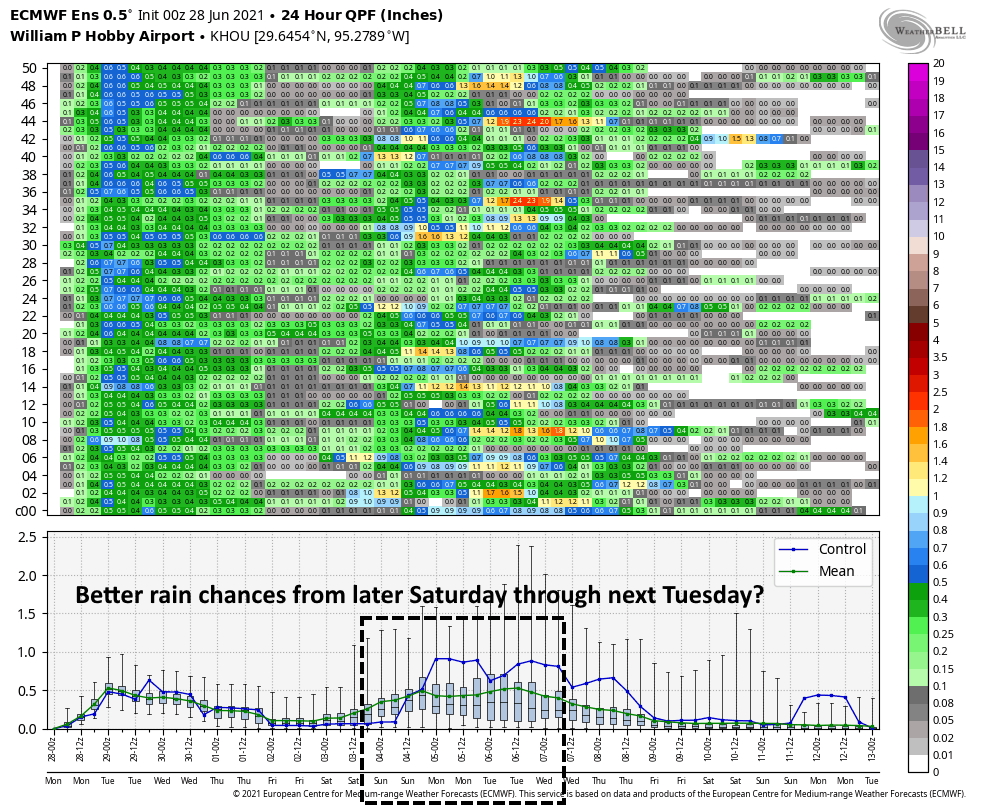
After a few drier days, in terms of rainfall, precipitation chances will probably be on the rise this weekend as the atmosphere turns more unstable. Unfortunately, we’re still a little too far out to have much confidence in the overall forecast, but right now I’d pencil in 60 percent rain chances each day, which could be problematic for outdoor activities. Given that we’re still several days away, this forecast is far from locked in, but something to keep in mind.
Tropics
We’re likely to see tropical activity pick back up this week after a lull in late June, but for now we don’t see any real threats to Texas or Louisiana over the next week or two. We’ll have more in our weekly tropics report tomorrow.
The TV weather guy didn’t tell anyone to stay home all day, so I guess it’s not going to be bad.
How many weekends can the weather ruin in 2021?
I’d be careful asking that question since Mother Nature may really show you what she can do to ruin your weekend/month/year. On the bright side, it isn’t baking here like it is in the Pacific NW.
I’ll gladly take the cloud cover and a bit of rain to keep the temps down. Lower temps mean less likelihood of a tropical system.
Houston has never had great weather – even when the Allen brothers were trying to snooker people into settling here.
…all of them?
Not that I want to experience what the PNW is, but did we switch weather this week or what? :/
“with lows dropping into the mid-60s tonight as shower activity wanes” ???
LOL…I know, right. #SeattleComeGetYourRainButKeeptheHeat
Backyard is already flooding. The neighbors across the back tore down a house and put more soil to raise the level, making everyone else flood.
That Hobby Airport graph looks like it was stolen from Bletchley Park.
For those bemoaning our current weather, just think back exactly ten years ago to the summer from hell – 2011: severe drought, water rationing, an August with 30 of its 31 days hitting at least 100 degrees. In comparison, this summer has been (almost) pleasant.
Montrose resident here. We received 3 inches this morning. Guess we’re done.
2.5″ of rain in Rosharon overnight, and more since then.