In brief: I hope everyone is enjoying the weekend. Just a quick post this morning to update our thinking on the potential for storms later today, and what this all means for our weather on Easter Sunday.
Saturday and Saturday night
The Houston area radar should remain largely quiet this morning, but off to our northwest I expect an area of showers and thunderstorms to begin developing in the Brazos Valley. We may see a few scattered showers and thunderstorms in the Houston metro area this afternoon, but I suspect that this larger mass (or possibly line) of storms will not start moving into our region until 4 to 6 pm. The bulk of the storms will then move through between that time and around midnight, or shortly before.
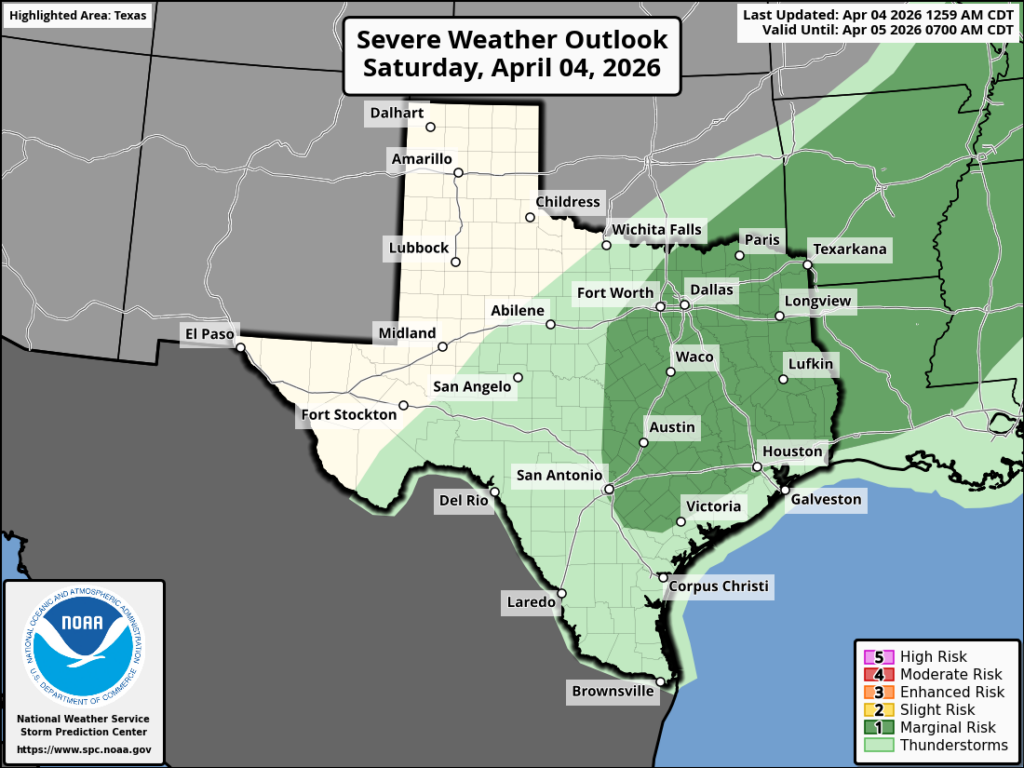
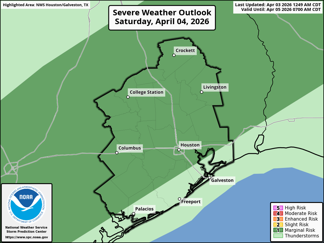
The potential for severe weather exists on Saturday, but it is not super high. (NOAA)
What to expect? There is definitely the potential for some briefly strong thunderstorms, although the overall threat level for damaging winds and hail is not particularly high. I’m not ruling anything out, but I don’t anticipate that most of us will see those conditions. Heavy rain is also possible, but again I expect this to be fairly sporadic rather than widespread. However, if you are out and about this evening in a spot that does get hit, know that we could see some briefly backed up streets.
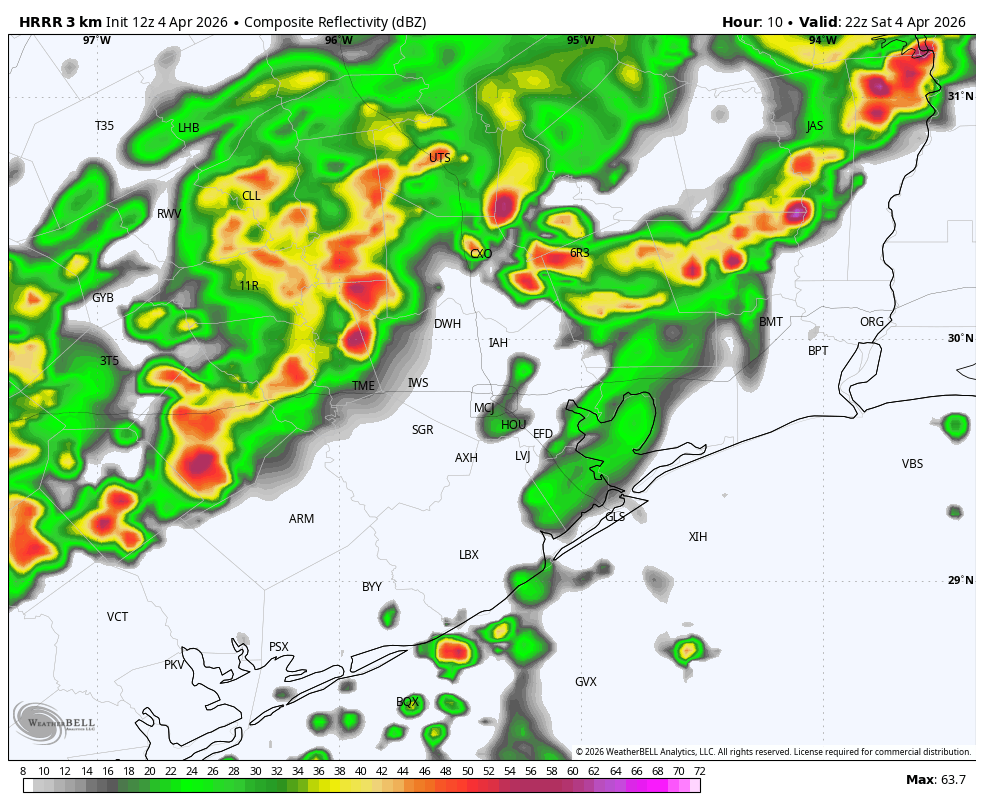
The HRRR model indicates a mass of storms approaching Houston at 5 pm CT this evening. We’ll see. (Weather Bell)
In terms of accumulations I expect widely varying totals. Some parts of Houston may get 2 inches, and other parts 2 tenths of an inch of rain between now and midnight. The signal for heavy rain is slightly stronger for areas north of I-10, but really anywhere is at risk. I’m hopeful that most of our area gets some much needed rain, but know that parts of Houston and surrounding counties will probably be disappointed.
Easter Sunday
The front will slog its way down to the coast during the overnight hours, and low temperatures should be in the upper 50s for most locations by sunrise on Sunday. Skies will be mostly cloudy and remain so throughout the holiday. If you see a speck of sunshine, count yourselves lucky. (So yes to bunny; no to sunny.) With some lingering moisture higher in the atmosphere, I expect that coastal areas (i.e. south of Interstate 10) could see some additional rain on Sunday. For the most part these rains should be light. Highs on Sunday will likely reach the mid-60s, or perhaps a touch higher. With lows on Sunday night dropping into the upper 50s, Monday night looks to be our coldest night of the week.
I hope everyone has an egg-cellent holiday and we’ll be back on Monday morning with our usual in-depth update.
In brief: Houston’s best chance at rain remains Saturday, where some parts of the area could see a stronger thunderstorm. Still, it will be a bit of an uneven distribution of rainfall, with some areas likely seeing little rain when all is said and done. Easter looks cool and dreary but overall, not very disruptive.
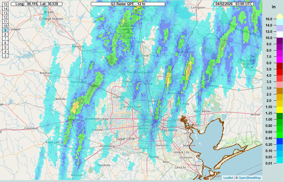
Pretty much as expected on Wednesday morning, most of the area was void of meaningful rainfall yesterday. So where did it rain? Go north.
Rain totals from late Wednesday night into Thursday night accumulated on the order of an inch or so around and west of Lake Conroe back through the Brazos Valley and in Sam Houston National Forest. (NOAA)
From the Brazos Valley to just near Lake Conroe saw anywhere from 1 to 3 inches of rain, as did a small bullseye south of Lake Livingston and in Sam Houston National Forest. The 2.81″ of rain in College Station was a record for April 2nd and the wettest day of 2026 with the most rain measured there since October 25th of last year. Good news for that area. For us? Frustrating, but that’s how it goes. Are the odds better tomorrow? Let’s discuss.
Today
Today should see clouds, some sun, and a few mostly inconsequential showers around the region. A few places may see up to a half-inch in a steadier downpour but most of us will see minimal rainfall or nothing at all. Highs will be in the mid-80s.
Saturday
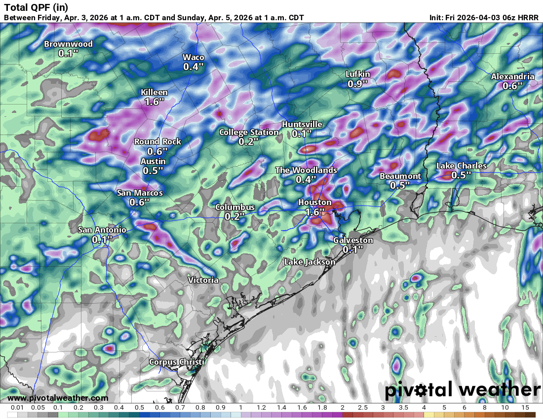
The front half of the day will probably much like Thursday and today across most of the area. We cannot rule out some passing showers, but primarily it will be cloudy with some sunny breaks, warm, and humid. A line of thunderstorms should begin developing near College Station in the early afternoon and drop south and east into the Houston area by late afternoon. Some of these storms could be on the stronger side, and the area is highlighted in a marginal risk (1/5) for severe weather tomorrow.
A marginal risk (level 1/5) is posted for areas away from the coast on Saturday for severe thunderstorms. (NOAA SPC)
As the storms push toward Houston, we may see the line become a bit more scattered in nature. Areas west of I-45 and north I-10 still stand the best odds of seeing appreciable rainfall on the order of 1″ or more. There are some signs that the boundary may stall near Houston or just south and east. That could allow for some additional rain to fire up through Saturday evening and overnight. Rest assured, we have alerted the Easter Bunny to wipe his paws at the door.
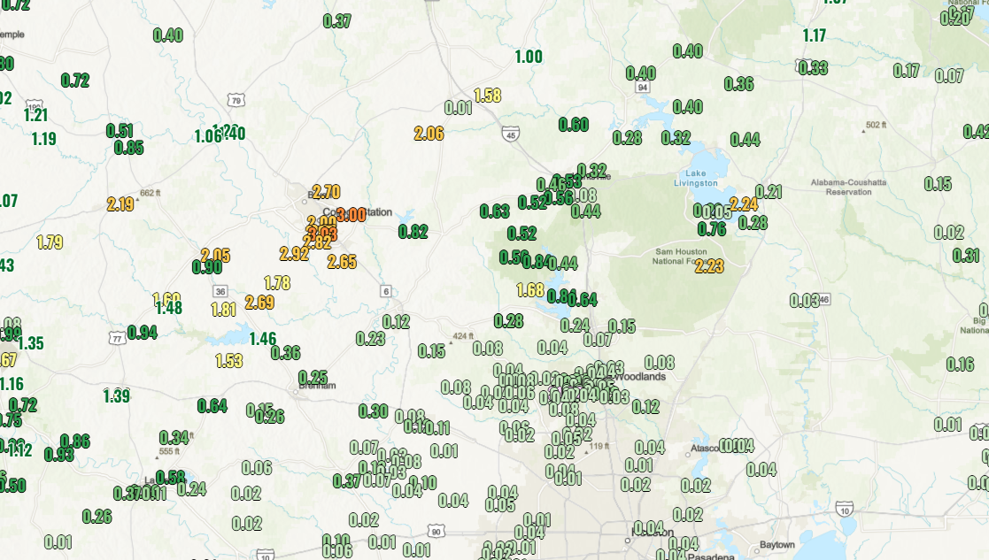
Don’t focus on the exact rainfall totals forecast from the HRRR model below, but you get the sense of how sporadic it may be, with some areas easily seeing 1 to 2 inches, while others see little to no rain at all.
HRRR model forecast rainfall through 1 AM Sunday. (Pivotal Weather)
Generally speaking though, we should see the rain trend toward less coverage and intensity from late evening to overnight.
Easter Sunday
With the front stalled out near the coast or just inland, we should see at least some low clouds, drizzle, and rain showers around south and east of Houston. So, if you’ll be attending any sunrise services, you may need a poncho. Some steadier rain is possible on Easter morning south of the region, toward Matagorda Bay or Corpus Christi. Highs on Sunday will be held back due to cooler air and cloud cover and may not get out of the upper 60s in much of the area.
Monday
Clouds or a shower may even remain with us into Monday morning, but we should see brightening skies with highs in the low 70s. Morning lows will be in the 50s.
Tuesday and Wednesday
A generally nice pair of days is setting up for midweek with highs in the mid to upper 70s and some sunshine. We could see a few extra clouds on Wednesday, along with a chance of a shower. But for the most part it looks quiet. Our coolest morning will be Tuesday, with lows in the 40s and 50s.
Later next week
We look to get back to a more active spring pattern later next week with at least the mention of shower or thunderstorm chances each day. As of right now, nothing in particular is standing out, but hopefully we can get some parts of the area a little more rainfall. We shall see.
In brief: Houston has a mixed bag of rain chances for the next few days, with Saturday still looking like the most bullish chance at rainfall. Despite warm, humid conditions in the near term, much cooler weather is expected to arrive on Sunday.
Quick notes
First off, I want to thank Eric for his kind post on Tuesday regarding my news of departure from Houston this summer. I am thankful for the opportunity to stay involved with Space City Weather as much as I have always been though.
Second, I left off one additional word of thanks in my post Monday, and that was to Reliant for being such an amazing supporter and sponsor for Space City Weather. Really, they just let us do our thing, hands off, and in return we periodically throw some useful messaging and information on what they provide to our audience. It feels like it’s been win-win, and I just want to make sure to share my appreciation and gratitude for their support.
Last, I want to congratulate everyone in the Houston area (and beyond) that has been involved in the Artemis mission. I mean…wow. The mission is of course nowhere near completed yet, but to be able to share that moment with my kids, a moment that those of us born after the early 70s have never experienced was truly special. And it’s not like we just watched the launch and then went about the evening. No, we fired back up NASA’s mission stream before bed to check on them. And we will be doing that many more times for this and future launches. I am hopeful this spurs new interest in space and support of science. Time and again it’s been proven that with human ingenuity and science, great achievements are possible. To the many folks that have brought us back to this point, thank you.
Onward…
Thursday and Friday
If you were lucky yesterday, you saw some rain. I literally looked outside, said “it’s raining,” and in the time it took me to comprehend that it was raining, it stopped. I’m not exaggerating whatsoever. “Blink and you might miss it” applied. Some folks did do okay though. The Sealy area saw over 0.75″ of rain in spots, including a 1.12″ from a Harris County Flood Control District gauge north of San Felipe. There was also a corridor of heavier rainfall north of Downtown with 1.25″ at a CenterPoint gauge along Tidwell Road and 1.16″ at 59 & 610.
Radar rainfall estimates from Wednesday showing the bullseyes north of Downtown and north of Sealy. (NSSL MRMS)
Yesterday’s rainfall came from south to north moving showers as gusty winds and Gulf moisture piled in. Yesterday was also one of the most uncomfortable days of this spring with the humidity. Today’s rain chances will be slightly different. The setup features showers and storms that are approaching Aggieland from the north and west as a boundary nudges toward the region. It’s unlikely that those storms are going to make it into the Houston Metro in an organized fashion. But some disorganized showers are already occurring across the area and a few storms are possible later this morning in places like Navasota or Magnolia or The Woodlands.
Friday will probably just feature a smattering of some light to moderate showers and nothing worse. Good news if, you’ll be attending the Dash game! Highs will be in the low to mid-80s both today and tomorrow with lows stuck in the 70s.
Saturday
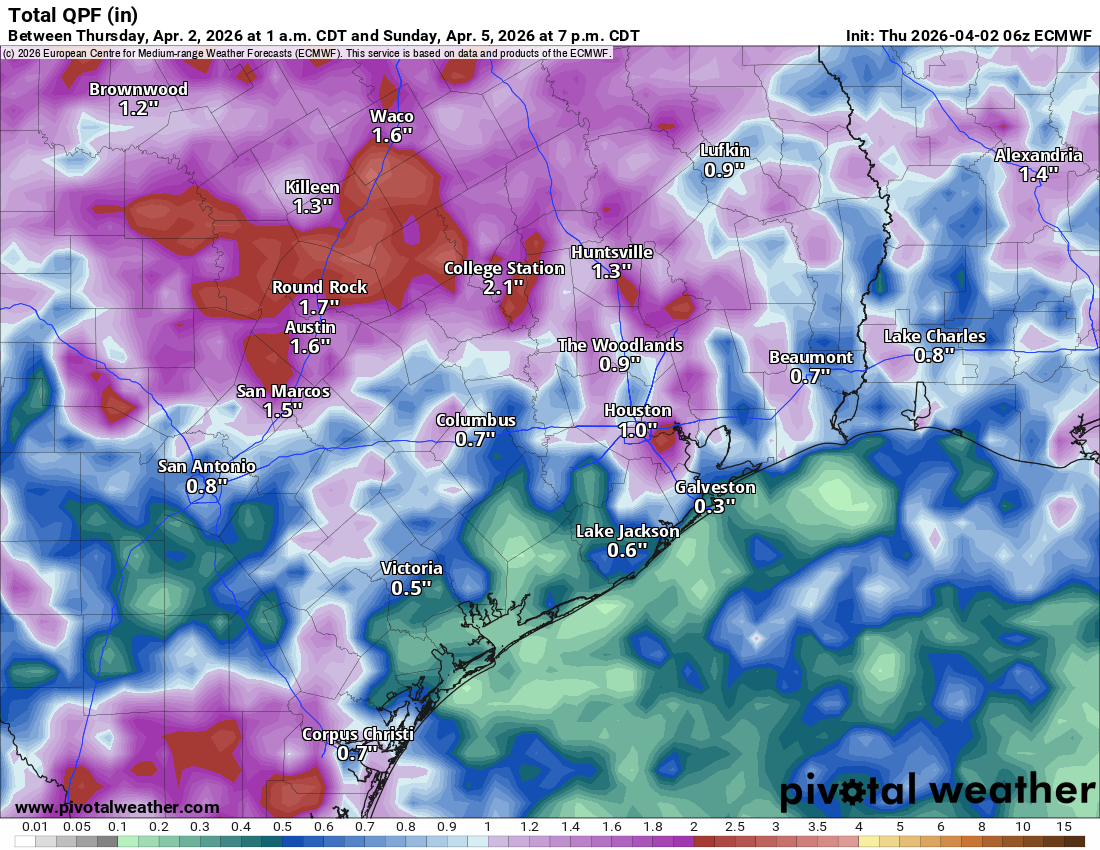
It appears that the first half of this weekend will feature our best chance for more widespread rain. That said, there continues to be some model disagreement on how resilient the coverage of that rain will be. In general, expect a solid line of showers and thunderstorms, including some that could be on the stronger side moving into the Brazos Valley early on Saturday afternoon. Those should begin to move into northwestern parts of the Houston Metro (Katy, Cypress, Magnolia north to Conroe) by late afternoon. The line of storms may peak as it enters the northwest fringe of the Houston area but then begin to fracture or fizzle during the evening hours as it moves south and east from there.
European model forecast rainfall through Sunday evening showing lesser totals south and east and isolated pockets of 1 to 2 inches or more. (Pivotal Weather)
As of right now I would expect the best chances of a half inch or more of rainfall on Saturday to be north of I-10 and west of I-45, with the lowest chances south of I-10 and west of Highway 288. Rain totals may end up ranging from a quarter inch in the Wharton area to a half inch or so at the coast to 1.5 or 2 inches northwest of Houston. We’ll fine tune this again tomorrow.
Sunday
Clouds and light showers may linger on Sunday, especially south and east of Houston. It will also turn sharply cooler on Sunday. Expect highs near 70 degrees north and west to low or mid-70s south and east. An additional disturbance may pass to the south of our area Sunday evening providing a slight uptick in rain chances for the Matagorda Bay region into Galveston.
Next week
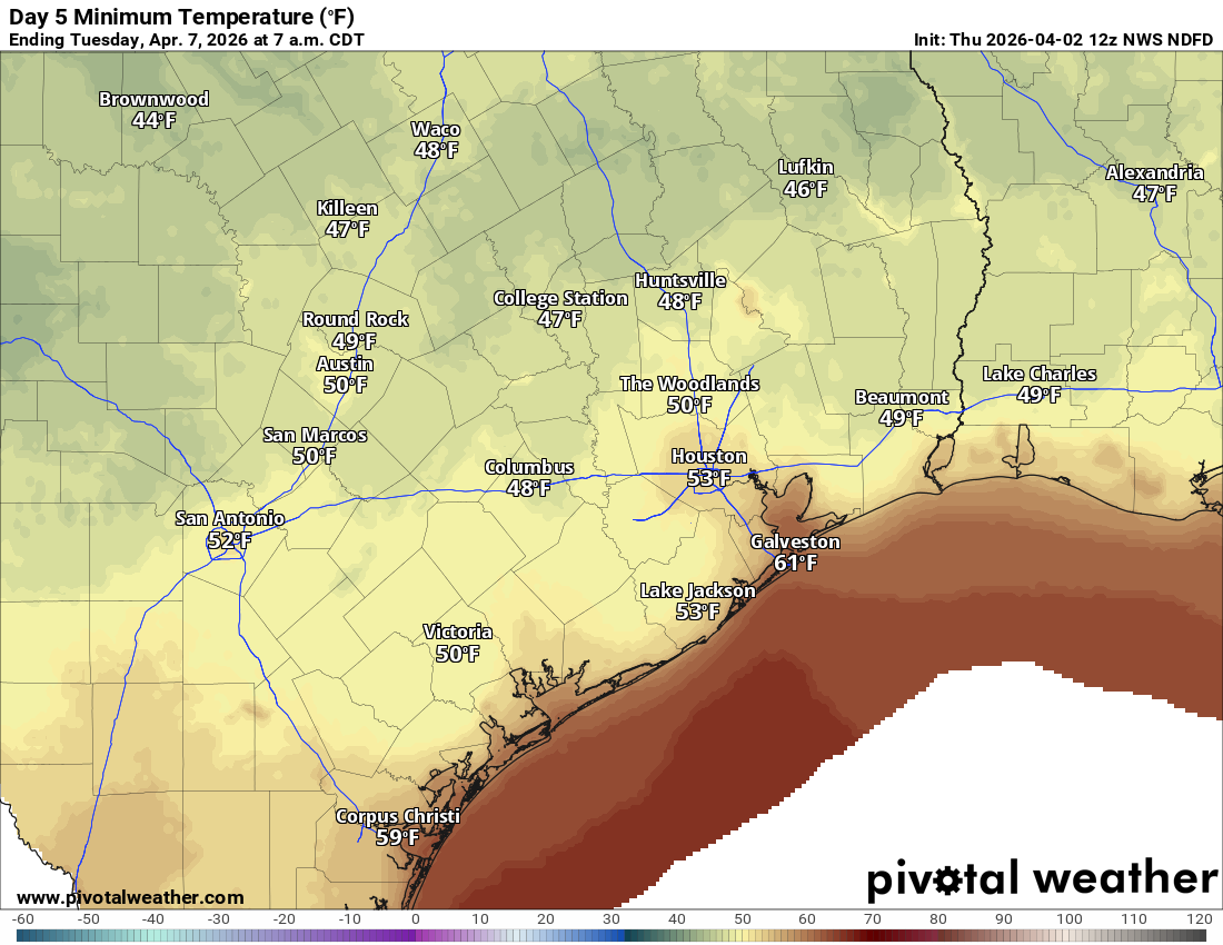
Cloud cover may linger into Monday morning, along with shower chances near the coast before things clear out a bit. This should lead to a decent Monday afternoon and Tuesday, with highs in the 70s. Morning lows will be in the 50s or even some 40s!
The return of cooler weather will happen from Sunday through Tuesday, with Tuesday morning’s forecast lows shown here. (Pivotal Weather)
Rain chances may begin to slowly return after Tuesday with gradual warming.
In brief: In today’s post we discuss this evening’s liftoff of four astronauts to the Moon, with fine weather conditions expected for the launch window. Closer to home we remain in a warm and muggy pattern, although Houston will start to see increasing rain chances today. Saturday still looks dynamic ahead of a cooler and gray Easter Sunday.
Update on Artemis II
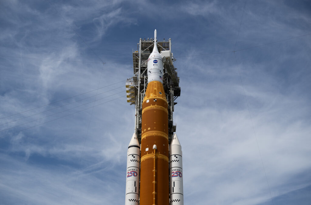
I’m in Florida this morning for the historic launch of Artemis II, during which four astronauts—who have been our neighbors here in Houston for at least the last decade—are scheduled to fly to the Moon. The two-hour launch window opens at 6:24 pm ET this evening, and local weather conditions are favorable for liftoff. There is always the chance of technical issues with the rocket or spacecraft, but if not, we’re sending humans back into deep space for the first time in more than 50 years. And these are really great people, Reid Wiseman, Victor Glover, Christina Koch, and Jeremy Hansen, whom we can all be proud of and cheer on. Following the launch window opening, there will be a full Moon at 8:11 pm ET. Seems fitting. My colleage and I at Ars Technica will be providing full coverage if you’re interested in knowing more.
The Space Launch System rocket and Orion spacecraft are seen on the launch pad on Tuesday at Kennedy Space Center in Florida. (NASA)
Wednesday, Thursday, and Friday
Alright, back to local weather. There won’t be much change over the next three days so I am lumping them together. We are going to see continued warm weather, with daytime highs in the range of the mid-80s, plenty of humidity, and very warm nights with temperatures only falling into the lower 70s. Southerly winds will also be frisky, gusting up to 25 mph or higher during the afternoon hours. We are also going to see some bonafide rain chances, but these showers will be very hit or miss. A few areas may see some afternoon thunderstorms whereas the majority of us only sees gray skies. Overall I expect most of Houston to pick up a tenth of an inch of rain, or two, over the next couple of days. But a few areas will get more.
Saturday and Sunday
Our weather this weekend will turn a bit more dynamic. We’re still outside the range of high-resolution models, but generally the picture is fairly straightforward. Saturday morning looks warm and muggy, but I don’t anticipate much in the way of shower activity. So basically a continuation of previous days.
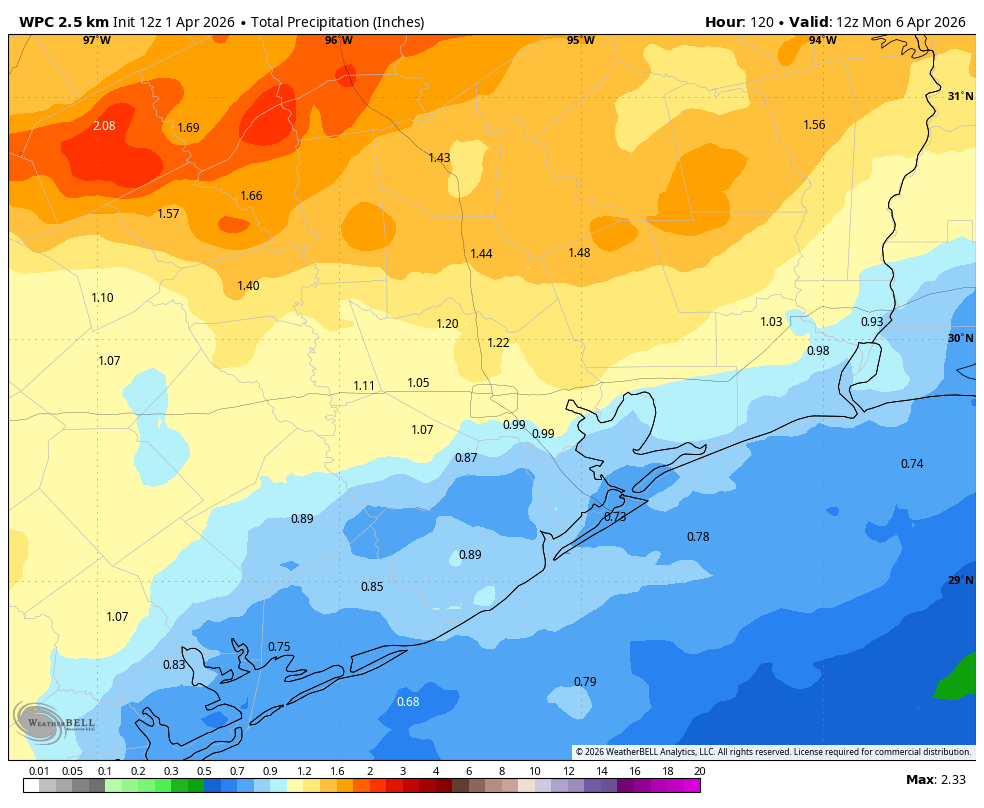
However, rain chances will increase during the afternoon hours, with the greatest likelihood of rain from mid-afternoon on Saturday to the early morning hours on Easter Sunday. For now overall conditions are not particularly supportive for severe weather, with the primary threat heavy rain. I don’t want to over-set expectations here. My hope is that most of the region receives a good soaking, with 0.5 to 1.5 inches of rain. Given the high atmospheric levels we cannot exclude the possibility of heavy rainfall briefly backing up streets, but I don’t think this will be too much of an issue.
NOAA rain accumulation forecast for now through Sunday. (Weather Bell)
By Sunday morning it will feel cooler outside, with temperatures in the upper 50s for most locations. If the front lingers near the coast for awhile, we may see some scattered showers on Sunday morning, especially for areas along and south of Interstate 10. Skies should remain mostly cloudy regardless, with daytime highs in the upper 60s. Lows on Sunday night will drop into the mid-50s in Houston, with cooler conditions for outlying areas.
Next week
Fine, spring-like weather will hang on through the middle of next week, with highs in the 70s and lows in the 50s. Daytime highs may rebound to around 80 degrees toward the end of next week, when some modest rain chances remain.