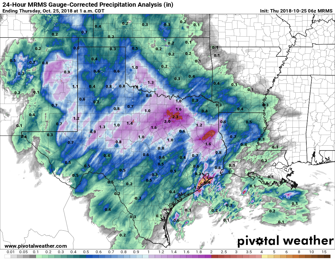
Moisture associated with the remnants of Hurricane Willa produced showers across the Houston area from Wednesday evening through Thursday morning. Most of the region saw less than 1 inch of rain, but southern areas of the metro area were harder hit, with a few parts of Galveston seeing as much as 4 to 5 inches of rainfall. Fortunately, we are all done with that mess now. We’ll now see a heavy dose of sunshine and drier air for the next six or seven days.
24-hour rain totals ending at 1am CT Thursday. The coast near Houston got hit hard. (Pivotal Weather)
Thursday
A few lingering, light showers southeast of Houston will push east by around sunrise. Skies should clear some today, but we’ll still see plenty of clouds, and that should limit high temperatures to about 70 degrees. In the background, northwesterly winds will be ushering drier air into the region, which will set up a really nice weekend.
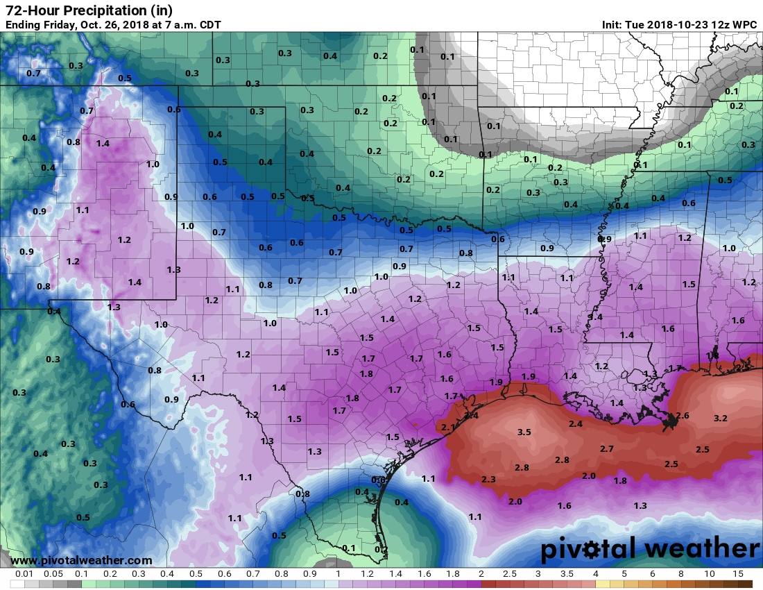
We’re going to have one day, and especially night, of widespread rainfall before the region gets a break from the precipitation. In fact, after early Thursday morning, it would not surprise me to see the region go an entire week without rainfall. So if you’ve been waiting for the region to really dry out, that time now appears to be at hand.
Wednesday
There are a few light showers about this morning, but it looks like the deeper moisture from the remnants of Hurricane Willa won’t push into Houston until later today, or during the overnight hours. Before early afternoon today, we’re likely to see mostly cloudy skies, with scattered light to moderate rain showers, and highs in the upper 60s. Winds will also be breezy, out of the northeast, with gusts up to 20mph.
Rain accumulation forecast for now through Thursday. (National Weather Service)
The real action will likely begin this afternoon to our west, or after sunset for eastern Houston. As we’ve been suggesting for a few days now, we don’t expect anything too extreme. Most of the region will likely see 0.5 to 2.0 inches of rain. Some thunderstorms are possible closer to the coast, but most areas will just see rain. Although soils are pretty wet already, these kinds of rainfall amounts should be manageable, and right now we wouldn’t expect anything more than some isolated, brief street flooding—if that.
Good morning. We’ll remain in a wet, gray pattern for the next couple of days before drier air and lovely weather arrive in time for the weekend. In fact, the weather for the upcoming Friday through Sunday period should make for the region’s nicest weekend since about April. We’ll also take an early look at the Halloween forecast.
Tuesday
Light to moderate showers are moving from west to east across the Houston area this morning, and high resolution models suggest this precipitation should come to an end around noon, or a few hours later. Accumulations should be modest, under 1 inch for most. Skies will remain cloudy after the rains end, and highs for the most part should stay in the 60s today—so cool and gray. Rain chances will be lower tonight, but not zero, with little overnight cooling due to thick cloud cover.
Wednesday
Texas will see some moisture from the remnants of Hurricane Willa on Wednesday, but nothing to be particularly concerned about. A few thunderstorms are possible, but for the most part we expect the region to just see 1 to 2 inches of rainfall from Wednesday morning through Thursday morning. Slightly higher amounts are possible along the coast.
Rain accumulation forecast for now through Thursday. (Pivotal Weather)
This shouldn’t be enough rain to cause problems for the Houston metro area, but central Texas certainly doesn’t need the additional rainfall. The City of Austin had to issue a boil water notice for residents on Monday due to problems with flooding at its water treatment facilities.
After a fine (so very fine) Sunday of fall-like weather in Houston, our gray, wet weather returns as early as later today. Part of this is due to moisture from Hurricane Willa in the Pacific Ocean, but as for now we aren’t overly concerned about excessive rains from this system on Tuesday and Wednesday in Houston. Finally, we should clear out for a pretty darn nice fall weekend.
Monday
Clouds will return today, as moisture streams in from the southwest. Some scattered showers are possible today, but better rain chances arrive tonight (around 70 percent for coastal areas, and 50 percent inland) along with low pressure along the coast. Most of the region will probably see less the one-half inch of rain during the overnight hours. Highs Monday will probably remain in the upper 60s.
Tuesday and Wednesday
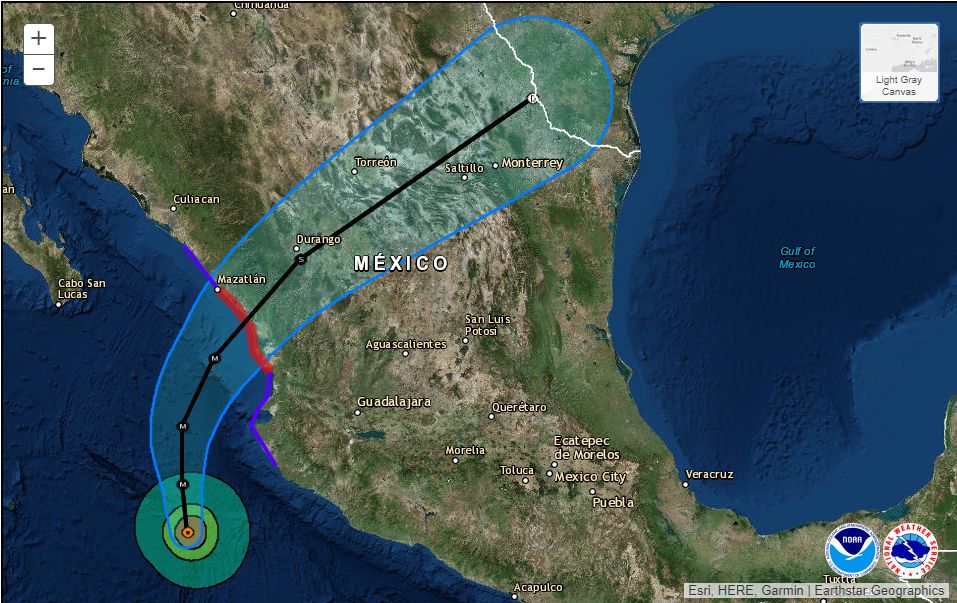
Our mid-week weather will be driven somewhat by Hurricane Willa, which should make landfall on Tuesday along the Western coast of Mexico, north of Puerto Vallarta. This is a powerful hurricane on Monday, with Category 4 winds, but Texas should only see rains and some moderately gusty winds from the storm as it weakens over Mexico and brings moisture into the United States later on Tuesday and Wednesday.
Hurricane Willa should make landfall on Tuesday. and weaken as it moves across Mexico (National Hurricane Center)
How much moisture? We’ve received several comments from readers about concerns expressed elsewhere about heavy rains in Southeast Texas. Even the most bullish members of the European operational model peak out at about 4 inches of rainfall for Houston, and most of them are in the 1-2 inch range. So that this time we don’t anticipate widespread problems, just fairly grim mid-week weather for Houston. (We have greater concerns about central Texas, where accumulations should be about the same, but where some historic flooding has already occurred this month.)