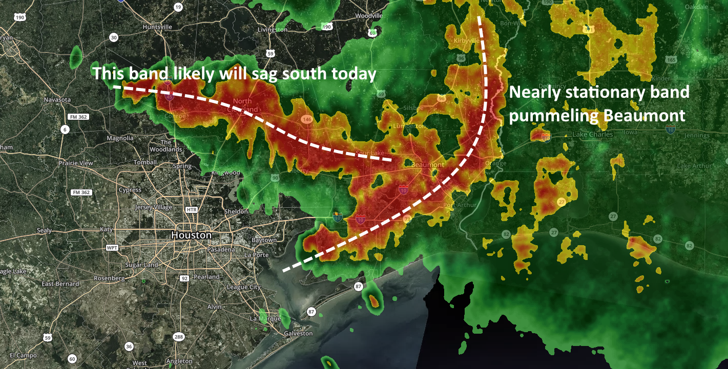
We’re continuing to track a very intense band of rainfall just north and east of Houston, which has been producing rainfall rates of 2 to 4 inches per hour. The National Weather Service has declared a Flash Flood Emergency until 11:15 am for Southeast Montgomery County, Northeast Harris County, and Liberty County. This is enough to quickly flood streets and back water up into yards (and over a long enough period of time, homes). This band is now slowly sagging into the Houston metro area, as seen on the radar image below.
Intense rainfall band sagging southwest toward Houston at 9am CT Thursday. (kktv.com/Space City Weather)
We do not have a ton of confidence in the forecast other than this band should progress through most if not all of Harris County today, potentially bringing 2 to 8 inches of rainfall later this morning and afternoon. We do not know if it will strengthen further (unlikely), remain the same, or (hopefully) weaken as it progresses throughout the day. Needless to say it has the potential to disrupt any activities today, and we are likely to see flash flooding in the metro area as it moves through.
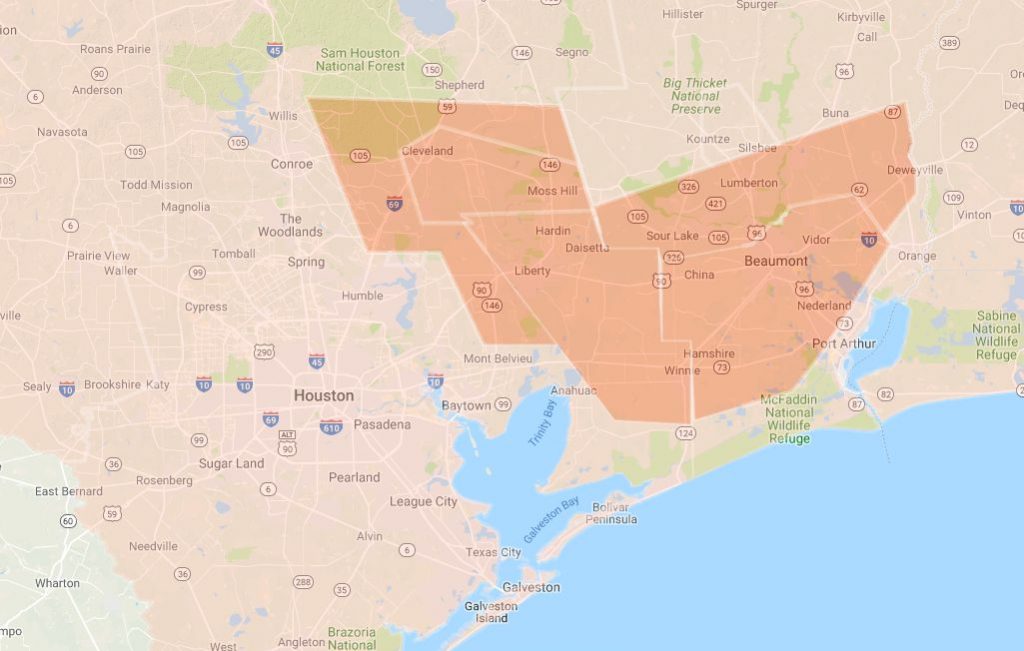
Meanwhile, the greater Beaumont region continues to experience a massive flooding situation as overnight rains devastated the area, and to some extent, are continuing this morning. The city has conducted hundreds of high-water rescues.
Good morning. Before jumping in to today’s post, I wanted to apologize for site outage problems during the overnight hours. This is very unfortunate timing and we will correct the problem going forward.
On Wednesday night, as anticipated, much of the Houston region passed a relatively quiet night. However, the same cannot unfortunately be said for regions to the east and northeast of Harris County. An extreme rainfall event has unfolded over Jefferson and Orange counties. This morning, the National Weather Service took the rare step of issuing a “Flash Flood Emergency” for the region, warning residents that, “This is an extremely dangerous and life-threatening situation. Do not attempt to travel unless you are fleeing an area subject to flooding or under an evacuation order.”
Area of flash flood emergency on Thursday morning. (National Weather Service)
This is really a terrible situation for Beaumont, Winnie, and surrounding areas. There are major issues on Interstate 10 through the area. Some areas have seen 10 to 15 inches of rainfall during the overnight hours, and a thick band of rainfall due to Imelda continues to saturate the area. It is showing no signs of movement for the next couple of hours.
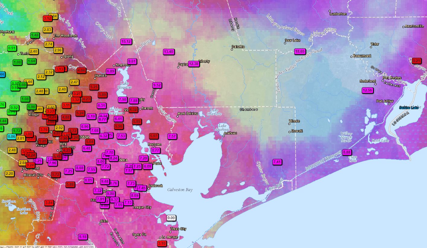
Imelda’s rains have been worst to the east of Houston. (TWDB)
With respect to Houston, we have some concerns later today. A related band of storms near Conroe and Cleveland will likely eventually sag southward today. Accordingly, parts of Montgomery County will likely see 2 to 8 inches of rainfall today, and some northern and central parts of Harris County may see 2 to 6 inches of additional rainfall. These areas of the Houston region have, until now, been somewhat unaffected by Imelda’s heaviest rains so they can probably handle most of this rain. That doesn’t mean there won’t be any street flooding, however.
Houston radar at 5:40am CT Thursday. (kktv.com/Space City Weather)
We probably will see some additional storm development later today, but most of the activity should wind down this evening as the sun sets. By Friday morning we should return to more normal, business-as-usual pop-up thunderstorms. So we’ve all got to get through one more day of Imeda-misery. We will update accordingly.
After a mostly benign afternoon, with the exception of some street flooding in Galveston, we are back in the thick of things now, as Imelda’s Wednesday night show is underway.
We just had a reported tornado west of Mont Belvieu, and a funnel cloud sighted in Deer Park. Other storms across the area are exhibiting at least some weak rotation, and it would not be surprising to see at least one or two more tornado warnings get hoisted before all is said and done.
We just got this photo of what appears to be a tornado on the ground. Brian Lockwood told us he snapped this near N. Main and 1942 headed towards Mont Belvieu. pic.twitter.com/ipA6S0bAg5
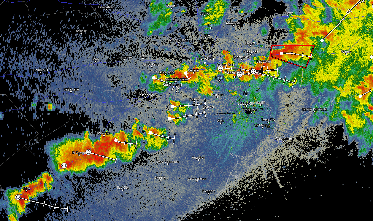
In terms of rainfall, a transient heavy rain band is setup along and south of I-10 from near Fulshear through Baytown as of 5:35 PM. That does not appear to be a “training” band at this time, but we’re watching to see if additional development will occur on the western flank. A secondary band is setup over Wharton County moving toward hard hit Matagorda County and parts of Brazoria County as well.
The radar situation at 5:35 PM Wednesday shows heavy rain in spots along and south of I-10 and also toward Wharton County, heading toward Matagorda and Brazoria Counties. (RadarScope)
So what are the expectations for the rest of tonight? I’ve tried to digest as much observational and model data as I can, and here are the key bullet points I think we can emphasize.
For Downtown Houston and points north and west (including The Woodlands, Conroe, Katy, Sugar Land, Kingwood, and Humble): Periods of heavy rain through the night. It may be more dry than wet in many locations, and at this point, I don’t see much reason to be too worried about things in those areas. We will watch late tonight for some heavier rain perhaps in the city of Houston or up toward Spring, Kingwood, and Humble.
South of Houston (including Pearland & northern Brazoria County) and southeast to Galveston County (Texas City, League City, Webster, and Friendswood): Periods of heavy rain early, perhaps becoming a bit more intermittent as the evening goes on. Given heavier rains here earlier today, some flash flooding is very possible.
Far south of Houston (Matagorda County, Lake Jackson, Freeport): Heavy rain this evening, with potential for another period or two of heavy rain overnight. Rain totals should be significantly lower than earlier today though.
Eastern parts of Harris County (Baytown, Mont Belvieu, Crosby): Heavy rain at times this evening, and then occasional periods of rain overnight. More concentrated, heavier rain possible toward daybreak. Flash flooding is a possibility.
Far eastern parts of the region toward Beaumont (Liberty, Hardin, Chambers Counties east to Beaumont): Frequent periods of heavy rain this evening and overnight. Flash flooding likely in spots. Significant flash flooding possible closer to Beaumont and perhaps points north.
I tried to cover as much as possible there. Folks farther northeast, in San Jacinto, Polk, and Tyler Counties will also see periods of heavy rain tonight and potentially some flash flooding.
Weather modeling has been all over the map in terms of how things finish late tonight and Thursday morning to the point of agitation, to be honest. However, some newer data is indicating that a more concentrated band of heavy rain could develop across Grimes and Montgomery Counties into northeast Harris and Liberty Counties, extending east, again, toward Beaumont. Should that occur, significant rain and potential flash flooding would occur, which could include The Woodlands, Spring, Humble, Bush Airport, and Kingwood. I want to just urge caution on that, as we still have some uncertainty surrounding how that will unfold. We will either update you later this evening or very early tomorrow morning.
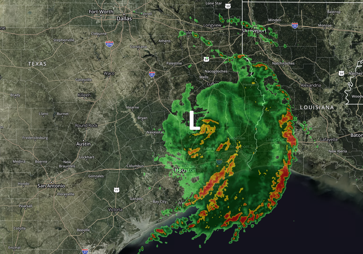
As of midday Wednesday, we’re starting to feel pretty good about the chance of Houston avoiding significant flooding from the remnants of Tropical Storm Imelda. We’re not entirely in the clear, to be sure, but the threat is shifting east away from the metro area. First of all, let’s take a big picture look at the radar at Noon.
Radar image at noon CT. (kktv.com/Space City Weather)
As you can see, Imelda’s remains are producing a very broad circulation, with several distinct banding features from along the Texas coast to well into Louisiana and northeast Texas. Houston residents will also take note that these strongest bands are generally moving away from the metro area.
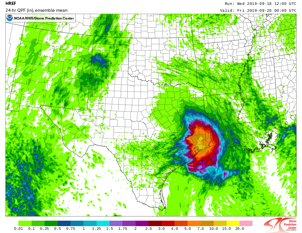
Based upon the latest modeling trends, we expect this trend to continue today. While the Houston metro area may see an additional 1 to 4 inches of rainfall over the rest of Wednesday and through Thursday (especially to the east of Interstate 45), the threat of sustained, heavy, and flooding rainfall is diminishing. We can see this based upon the HREF model output, which is an ensemble of several models that attempt to predict smaller-scale convection during rainfall events. Of all the models we’ve looked at so far during this event, the HREF has arguably done the best. Here is its output for now through Thursday.
HREF ensemble forecast for rain accumulation from midday Wednesday through Thursday evening. (NOAA)
The bottom line is that right now we expect the Houston region, including hard hit areas in Brazoria and Galveston counties, to generally see improving conditions from here on forward. Intermittent storms may well pop up, but right now, we anticipate that most areas can safely return to business-as-usual activities. For areas east of Houston through Beaumont, however, we definitely have concerns about ongoing heavy rainfall, and will continue to monitor that situation.