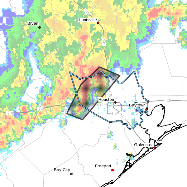
Rising moisture levels have combined with rising air to form some moderate-to-strong showers and thunderstorms this afternoon, primarily to the north and west of Houston. The National Weather Service has issued a flood advisory for some of these areas where up to 5 inches of rain have fallen. The advisory (shown below) is in effect through this evening for Houston.
Area of flood advisory in effect until 8:15 pm Sunday. (National Weather Service)
These storms are associated with an outflow boundary, and this complex should slowly move to the southeast this evening. As it does so, rain showers should move into the central and perhaps southern Houston areas, but the storms should also weaken as this happens because atmospheric conditions are less favorable closer to the coast. This is somewhat unfortunate, because the southern half of Houston has not seen significant rainfall in a month. Overall, I would expect showers to die out late this evening, or by around midnight.
Some street flooding is already occurring in areas of the flood advisory, but because the region has been so dry for so long, bayous and creeks should remain within their banks.
As Eric mentioned yesterday, for some in the Houston area, rain has been missing for a good while. And it looks like the next couple days will extend that streak. By Sunday and next week, however, a few subtle changes will at least allow us to at least mention showers again. But it is unlikely that all of us will see rain.
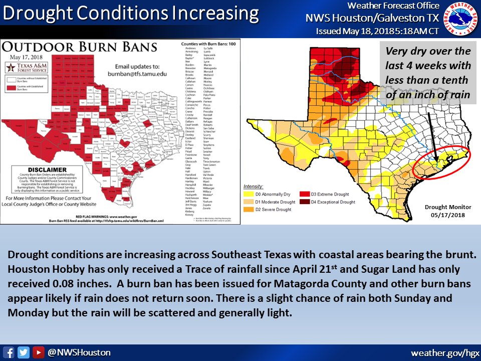
Dry conditions are expanding in Southeast Texas. (NWS Houston)
A quick side note here: I’ve seen some people mention how this is reminding them of 2011 again. We technically aren’t in drought yet. And at this point in 2011, the drought in Southeast Texas was orders of magnitude worse than it is now. So we have a long, long way to go before we’re at that level. Be aware that we have dry conditions, be smart and conscious about burn bans around Texas, and give some thought about conserving water where you can. But, no, this is not a 2011 redux as of mid-May 2018. We need some rain though.
Let’s get into the forecast details.
Today & Saturday
I don’t foresee much change in the overall weather pattern the next two days. Both today and tomorrow should be mainly sunny and hot. After hitting 96° yesterday, expect mid 90s this afternoon and lower 90s on Saturday afternoon. Nighttime lows tonight will drop into the lower 70s. Humidity should increase a little bit above where it has been for the last few days.
Sunday through Tuesday
As onshore flow returns, moisture will come ashore also. Precipitable water (a good measure of how much moisture is available for thunderstorms) is around an inch right now, a little bit below average for this time of year. By Sunday that rises to around 1.5 inches, or around normal. We might be able to stretch it a little bit higher Monday and Tuesday, but for all intents and purposes, we’re just getting back to average here. That should mean that with daytime heating we will see at least a few hit or miss downpours develop each afternoon, especially Monday and Tuesday. But widespread soaking rain seems highly unlikely.
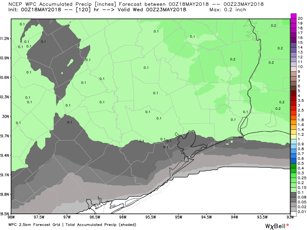
The NWS Weather Prediction Center rainfall forecast over Southeast Texas shows an average of around a tenth of an inch through Tuesday. Showers will be limited, despite a more typical setup. (Weather Bell/NWS)
I don’t think everyone will see rain early next week. Hopefully most of us see a little something here, but I’m not overly optimistic.
All three days will see high temperatures around 90 degrees, give or take a couple degrees. Our evenings will be sultry, with lows in the mid 70s, but perhaps close to 80 degrees in Galveston.
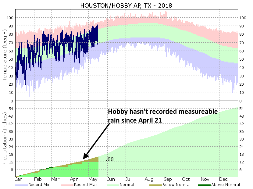
So far this month, Houston’s Hobby Airport has recorded only a “trace” of rainfall, which means there has been no measurable amount of precipitation. Looking back at the records for Hobby Airport, which date back to 1931, this has happened just twice at the site previously—in 2003 and 1937. Although I think there’s a chance the airport site makes it through this month without getting any measurable rainfall, I think there’s a greater chance that the region finally sees at least some modest rainfall next week. Let’s hope so, because Hobby (and a lot of other locations in the southern half of the metro area haven’t seen meaningful rain since April 21).
Houston’s Hobby Airport hasn’t recorded measurable rain since April 21. (NWS/Space City Weather)
Thursday and Friday
Houston will remain unseasonably warm to end the work week, with high temperatures likely in the low- to mid-90s, and mostly sunny skies. Nighttime lows in the lower 70s. Near zero percent chance of rain.
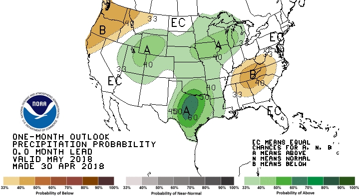
Long-time readers of this site will know that we don’t place a whole lot of confidence in seasonal forecasting. Trying to predict weather (note that’s “weather” not “climate”) conditions months in advance is not exactly an exact science. Case-in-point: Much of the Houston area has not gotten a drop of rain in the month of May, and the next week or so looks dry. And yet here’s NOAA’s monthly outlook for precipitation for the month of May, issued on April 30th:
Probably of wetter (green) or drier than normal conditions in May. (NOAA)
This forecast, quite clearly, will likely bust. And it was issued the day before the month of May began. So while I do think there is some value in seasonal forecasting, you should not take it to the bank.