Welcome to the weekend, everyone. We’ll be updating the site both on Saturday and Sunday out of an abundance of caution, rather than because we’re particularly concerned about the potential for flooding this weekend. The overall story remains the same: heavy rain potential increases on Sunday and Monday, with the biggest threat some localized high rainfall rates. As Houston floods go, this is not likely to be a memorable one.
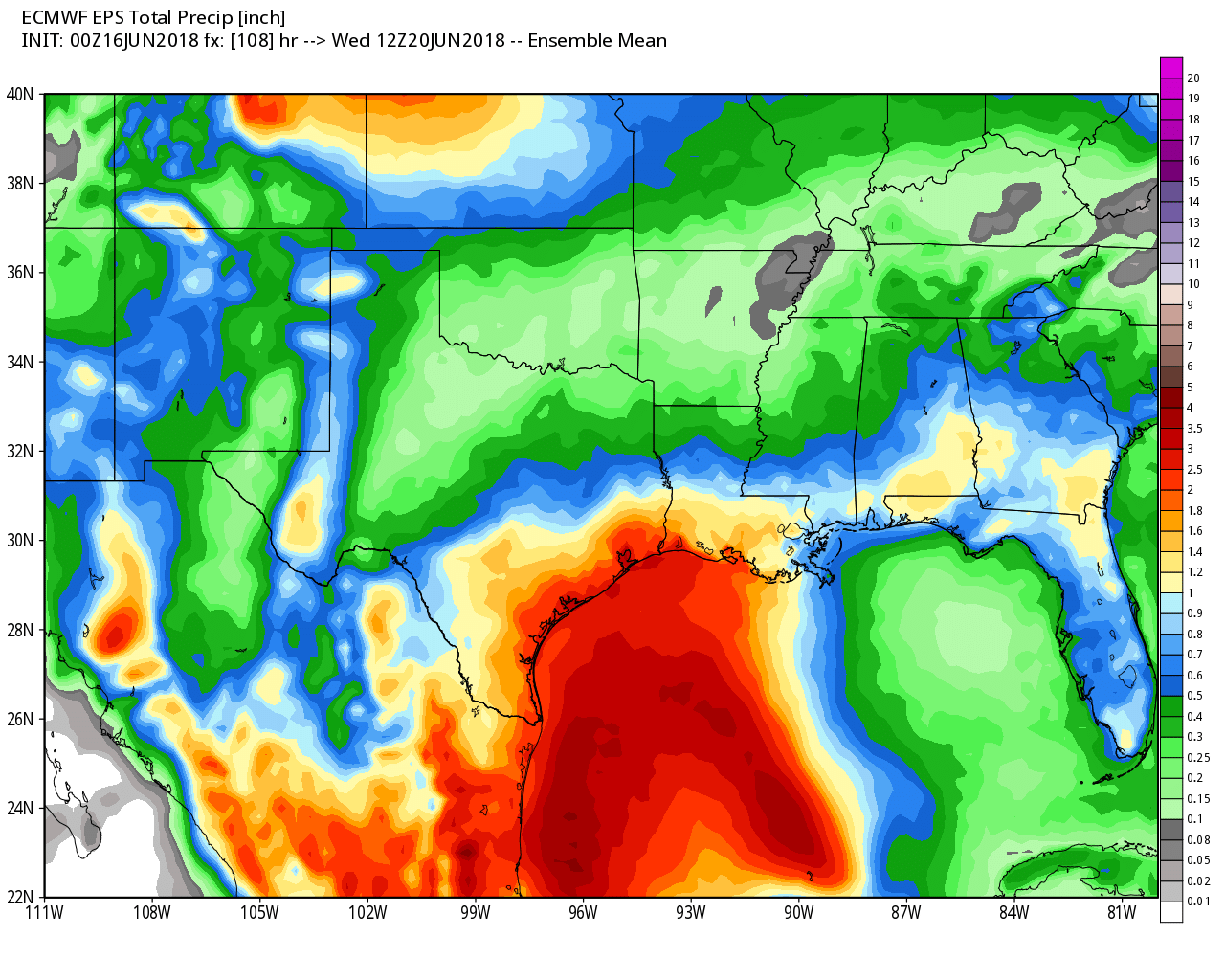
Average of rainfall forecasts from the European ensemble model for now through Tuesday. (Weather Bell)
Saturday
The weekend will start out mostly sunny, with a high in the low 90s on Saturday. Rain chances should increase later today, with 30 to 50 percent chances near the coast, and lower chances inland. Because moisture levels won’t spike until Sunday, we don’t anticipate any concerns from heavy rains. If you have outdoor plans today, I’d press ahead.
Please allow me a few words of reflection this morning before we get to the forecast. (It really hasn’t changed much—2 to 4 inches of rain for much of the area, with the potential for greater amounts possible in some locations. We have some concerns, which we discuss below, but don’t anticipate major, widespread problems at this time).
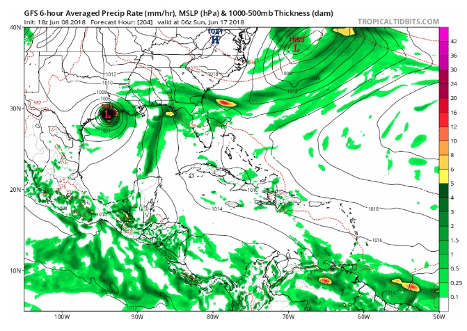
Amazingly we have been talking about the rainfall for “this coming weekend” for nearly a full week. This began late on the afternoon of Friday, June 8, when a couple of local forecasters looked at the GFS operational model (re-posted below) and called attention to the fact that it showed a hurricane moving into Texas on Sunday, June 17. I was taking a family vacation at the time, but received several messages from readers concerned about this, so I asked Matt to write about it. He authored an excellent update titled, “Yes, we saw the Friday PM GFS model; we aren’t stressing.” This kind of perspective is precisely why we started this site.
The GFS model run last Friday showed a hurricane hitting Texas this Sunday. Oh noes! (Tropical Tidbits)
What concerns me is that we have now been writing about this event for a week, and there is a non-trivial chance that for much of Houston this will not be more than a few significant thunderstorms. This sort of rainfall does not warrant the amount of attention it has received. And if Houston does receive the 2-4 inches of rain over a few days that we anticipate, it will degrade public confidence in meteorology as the hype will not match reality—i.e. the boy who cried wolf. I understand that people are highly sensitized after Hurricane Harvey, but every storm is not Harvey (or even close). So I just wanted to reiterate what I wrote at the outset of hurricane season: “Social mediarology” plays on the fears of people, and therefore tends to get shared widely. If you’ll promise to not fall for these kinds of fear-mongering posts, we’ll make a pledge to you: If we believe there is a credible threat to Houston, we will report that immediately. And if we haven’t written about it, the post you’ve seen on Facebook is probably garbage. Fortunately we have a sponsor like Reliant, which doesn’t value clicks, but rather reliability. Now, on to the forecast.
Cooler and significantly wetter weather remains on tap for the weekend—at this point Sunday looks like the wettest day—but with a disorganized tropical system moving into Mexico we don’t see any signal yet for widespread, significant flooding. So we’re watchful, but not overly concerned at this point. If you’ve been following along with Matt’s updates this week, you pretty much know what to expect.
Thursday and Friday
Houston endured highs of 97 degrees on Tuesday and Wednesday of this week, and that trend should pretty much continue to end the work week. Warm days will be punctuated with isolated to scattered showers, some of which can be intense as we saw with some storms near Tomball on Wednesday evening. But for the most part, conditions will just be hot and partly to mostly sunny.
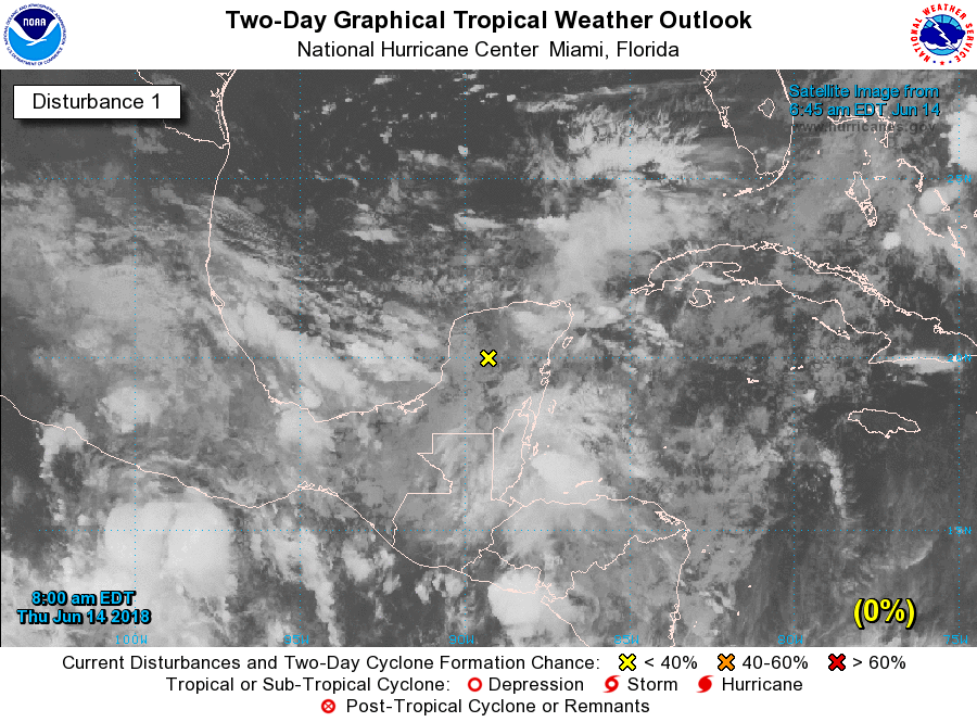
Tropical disturbance
We continue to think the tropical disturbance now moving over the Yucatan Peninsula, which will move westward into the Bay of Campeche and likely into northern Mexico, will not develop. That means that the primary threat from the system remains tropical moisture, which should spread into Texas this weekend.
The National Hurricane Center gives the tropical disturbance a 0 percent chance of developing during the next 2 days, and a 10 percent chance the next 5 days. (National Hurricane Center)
The key question is where the greatest amount of moisture will surge inland, and unfortunately we can’t say this with any precision. Will it be Houston? Beaumont? Victoria? We just can’t tell you yet. With that in mind, here’s our best stab at forecast conditions for this weekend.
Today, we’ll walk you through the forecast once more. Toward the end, I have tried to ask and answer the most common questions folks would have about the upcoming rain event this weekend. I think you’ll find most of your answers there.
Today through Friday
No changes to the forecast the next few days. Expect more partly to mostly sunny conditions. High temperatures will peak in the low- to mid-90s. Yes, a few showers or a thunderstorm will be possible on each day, but consider yourself lucky if you receive one. Most of us should remain dry.
Saturday
One of the changes today is that Saturday now looks like our transition day instead of Friday. Precipitable water values, which measure the availability of moisture in the atmosphere, go from about 1.5 inches on Friday to 1.9 inches on Saturday. What does this mean in layman’s terms? It means rain chances should go up a notch. As of right now, Saturday’s rain and storm coverage shouldn’t be terribly significant, but it will be more than we’ve seen lately. Locally heavy downpours could occur Saturday as well. With more clouds and rain, temperatures will ease back a bit, and we may not even hit 90 degrees for a change on Saturday.