Houston’s seemingly unending summer continues this week, with little break in the temperatures, humidity, or in a few days, rain chances. We’ll also discuss a tropical blob in the northwestern Caribbean Sea that ultimately shouldn’t have much effect on the region’s weather.
I was asked in a KUHF radio interview on Tuesday about the lack of fronts this year, and I said the most depressing thing about it is that we’re missing out on potentially great weather. October and November often see some of the nicest weekends of the year, and none of these are yet in sight. It’s a rather lousy thing.
Wednesday and Thursday
Some dense fog has developed over central and northern parts of the Houston area, and the National Weather Service has placed an advisory in effect until 10am. After this, weak high pressure should allow for partly sunny skies on Wednesday and Thursday.
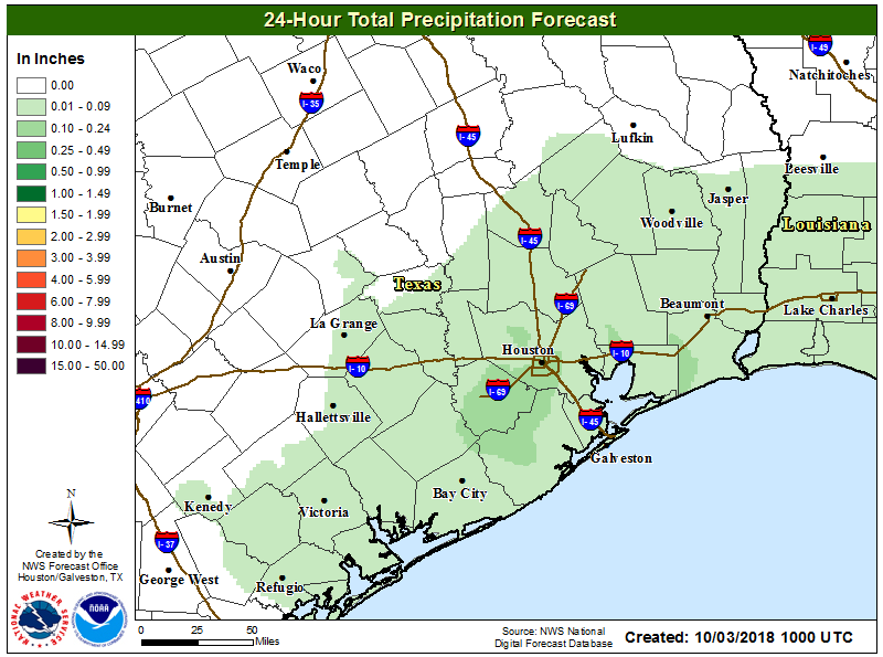
Wednesday’s forecast precipitation, shown here. This will probably be the region’s driest overall day for the next week. (National Weather Service)
Some areas will still see rain showers and possibly thunderstorms over the next two days, but accumulations should not be too significant—likely in the tenths of an inch. Highs will be near 90 degrees both days, and may reach that mark where skies are sunnier for longer.
After a prolonged period of wet weather, the Houston region will see a moderate reprieve as we break from a pattern of widespread, daily rainfall. (Showers aren’t going away entirely, however). It is during this break that we will look for the region’s first real fall cold front. We’re overdue, now—way overdue. As you may recall, we’ve made the arbitrary decision to define this front as the first night after September 1 with an overnight low temperature of 65 degrees or lower at Bush Intercontinental Airport.
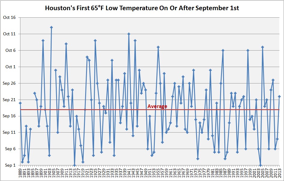
Houston’s first fall cold front. (Brian Brettschneider)
The average date for this first front is Sept. 18—two weeks ago—but there is a wide range of variability. For example, it is not unheard of for the first front to arrive in October. It happens about once every 10 years, on average. However, it is rare to get too deep into October without a cold front, and the latest Houston has waited since at least 1889 is October 13th. I’m afraid we’re in danger of setting this record this year.
Per the ensembles of the GFS and European forecast models, the region’s first cold front is unlikely to arrive in Houston this year any time before a time period between Oct. 11 and Oct. 15—nine or 10 days from now. Ughhhhhh.
Tuesday and Wednesday
As higher pressures move into the region, our weather pattern will turn moderately warmer, with high temperatures likely in the upper 80s. Temperatures will ultimately depend upon the amount of sunshine this afternoon, as we expect partly sunny skies. Rain chances will fall back into the 30 percent range, with showers most likely during the late morning and afternoon hours along with daytime heating. Lows in the mid-70s.
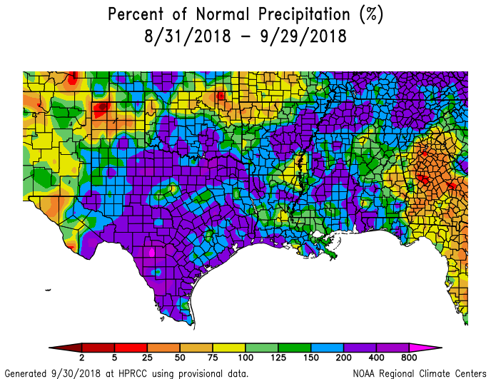
Well, we made it through the end of September. And a strange month it was. No tropical storms or hurricanes hit Texas, and yet it has been one of the wettest months in the state’s history. Much of the state received 200 to 400 percent normal levels of rainfall, including all coastal areas of the Houston region (Galveston will record its second wettest September ever, and third wettest month of all time).
Departure from normal rainfall for the last 30 days. (NOAA)
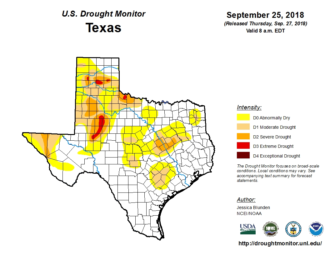
As a result, at the end of a summer in which no tropical storms or hurricanes moved into, or near Texas, the state finishes the hottest part of the year with just eight percent of the state in a “severe” or worse drought. This is a really healthy posture to be in, compared to typical years for Texas at the end of September.
U.S. Drought Monitor.
That does not mean September has been particularly fun. Heavy rainfall during the last month has, on at least three occasions, brought significant flooding to Galveston Island and other coastal areas. For much of the region, nearly all of September was a soggy, humid mess with cloudy days and steamy nights. Speaking personally, I am not sorry to see it in the rear view mirror. Now, onto the forecast.
Yesterday was nice. It wasn’t perfect, no, but it’s a start on our road to autumn. Unfortunately, like many Houston freeways, the road there is still under construction. More on that in a second. First, some news.
NOAA analysis finds significantly higher rainfall frequency values in parts of Texas, redefining the amount of rainfall it takes to qualify as a 100-year or 500-year event. https://t.co/vgfHqve8whpic.twitter.com/bY9FtLiMDB
NOAA has completed their analysis of rainfall return period in Texas. Those maps we’ve utilized for 100 and 500 year floods are now officially obsolete. In the Houston area, a 24 hour rainfall of around 13″ used to be required to classify a rainfall event as a “100-year flood.” Remember a “100-year flood” is a flood that has a one-percent chance of occurring in any given year. That 13″ rainfall has been revised up to 18″ of rain in 24 hours to qualify as a 100-year flood. Basically, what we used to define as a 100-year flood is now a 25-year flood. I think most of us knew this already; it had been telegraphed last year, but we can now make it official.
Why is this changing? The previous maps are decades old. The primary reason is that we have more data and better data to work off of. We also know, based on plenty of data, that rain events are getting bigger in Texas, and this is especially disproportionately true in the Houston-area. Ultimately, there will be ramifications because of these map changes. Infrastructure is built to these map standards. Floodplain regulations are based on these map standards. These changes have been well-telegraphed since Harvey, so some of this process is already underway. But it’s a slow process, so don’t expect changes next month. It’s a start, however.
On to the weather…
Today
Radar is mostly quiet this morning, though we are beginning to see a few showers near the coast as of 5:30 AM. More noticeably, we still see a good deal of cloud cover in the area.
A satellite loop shows low clouds (white), mid-level clouds (yellow), and high clouds (dark colors) moving through the area this morning. Sunshine will be at a premium, especially southeast of Houston today. (College of DuPage)
On the loop above, the bright white indicates lower stratus clouds and the darker colors indicate higher cirrus clouds. The yellow offshore indicates showers and mid-level clouds. Bottom line: We have a lot of clouds around, so sunshine will be limited today, especially south and east of Houston.
As the day goes on, we expect to see scattered showers and storms develop, initially near the coast and spreading a bit further inland as yesterday’s cold front begins to return as a warm front. Look for high temperatures today to hit the low-to mid-80s.