As expected, higher moisture levels are pushing into the Houston region from the Gulf of Mexico today. This will lead to storms across the area, possibly widespread, as temperatures warm into the 80s later this morning. This provides the potential for a quick pickup of 1 to 3 inches of rain for a few areas, and depending upon the rainfall rates we could see some temporary street flooding.
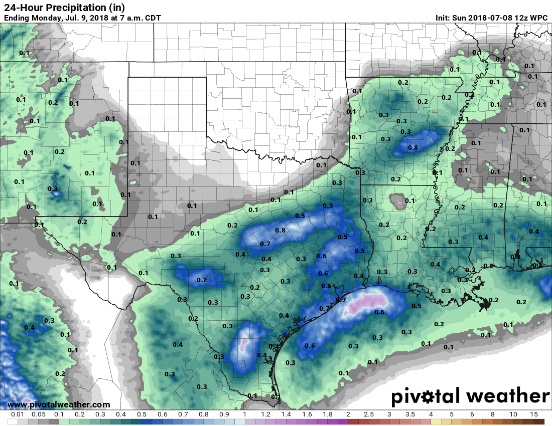
Widespread totals will probably only be about one-half inch of rain today, but we will see higher isolated amounts. (Pivotal Weather)
The bottom line is that if you plan to be out and about from around noon to 6pm, check the radar, and be weather-aware. We’re not expecting widespread problems, but you should definitely be prepared for storms to pop up quickly, and drop a lot of rain. Monday will probably be similar (although with less coverage) before rain chances begin to dial down significantly on Tuesday.
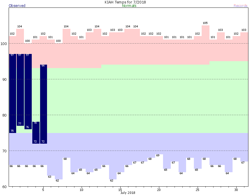
Anyone who has lived in Houston knows there are basically two choices for weather during the months of July, August, and the beginning of September: Hot, sunny, and humid; or Warm, wet, and still humid. Houston has experienced both of these extremes already in July, with three days of highs in the upper 90s, followed by a day of 70s and heavy rain on the July 4th holiday. Over the next several days we’ll lean more toward the warmer and wetter variety, with an eye toward more widespread, heavier rainfall returning Sunday.
July in Houston: Do you want heat, or monsoons? (National Weather Service)
Friday
Storms have remained offshore this morning, and some slightly drier air has worked its way into the Houston region. However, as temperatures warm into the mid- to upper-80s later this morning, and the sea breeze gets going, I expect we’ll see some decent rain showers this afternoon, with a few heavy cells setting up (like we saw on Thursday, with a narrow, but heavy band of showers near Highway 288 and the South Sam Houston Tollway). I don’t expect significant problems. Look for highs around 90 degrees, or a bit warmer depending on how much sunshine your area sees this afternoon.
Saturday
I expect Saturday will be a lot like Friday, although with a few more clouds, and slightly reduced rainfall chances. The potential for heavier rainfall remains low, and any intense storms should be fairly scattered in nature. Highs in the low 90s.
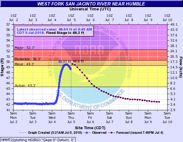
The West Fork of the San Jacinto River near Humble briefly went into flood last night, but it has since fallen back a bit. Other bayous and rivers are receding or safely below flood stage as well. (NWS)
Calmer weather doesn’t mean totally dry, however. Over the next several days we’ll be dealing with a few disturbances to bring us more rain chances, though at this point none look quite as significant as what we just experienced.
Today
We’ll see a return of some sunshine and heat today, as we start the day partly to mostly sunny. A few showers will be possible south and west of Galveston this morning, down through southern Brazoria and Matagorda Counties. As we heat up, I do expect at least a few more showers and storms to develop elsewhere in the region, but these will be more of the hit and miss variety, with many neighborhoods staying dry today. Expect high temperatures in the lower 90s.
Any storms that do occur today will be capable of briefly heavy rainfall and some gusty winds, as well as lightning. So just be aware of that.
The worst of the rain is now over as of early this afternoon in Houston. Heavier rains have migrated west toward the Sealy area, which has seen 1-3″ of rainfall over the last hour or two.
2:05 PM radar update shows the worst of the rain has exited #Houston. Residual street flooding will continue for several hours, so travel is discouraged. Heavy rains near Sealy are likely causing road flooding out that way also. pic.twitter.com/vJdbcpbTAA
A Flash Flood Warning remains in effect there. Houston’s Flash Flood Warnings will expire soon, but with street flooding likely to continue, travel within the city through the late afternoon is discouraged. We’d advise people to just stay put through late day if possible. Road and weather conditions will improve this evening.
Significant flooding on I-69 and Westpark Tollway interchange in Southwest Houston this road has at least 17’ of water in some places. @JeffLindner1#houwxpic.twitter.com/fhaVJUzLoJ
While weather conditions will generally improve area-wide this afternoon and evening, there will still be a few showers and storms scattered about the region. So I can’t promise the evening will be entirely dry. But it should be mostly cleared out. Still, a sub-optimal July 4th overall.
No change in thinking from earlier this morning regarding tomorrow and into the weekend, as additional showers and storms will be possible each day.
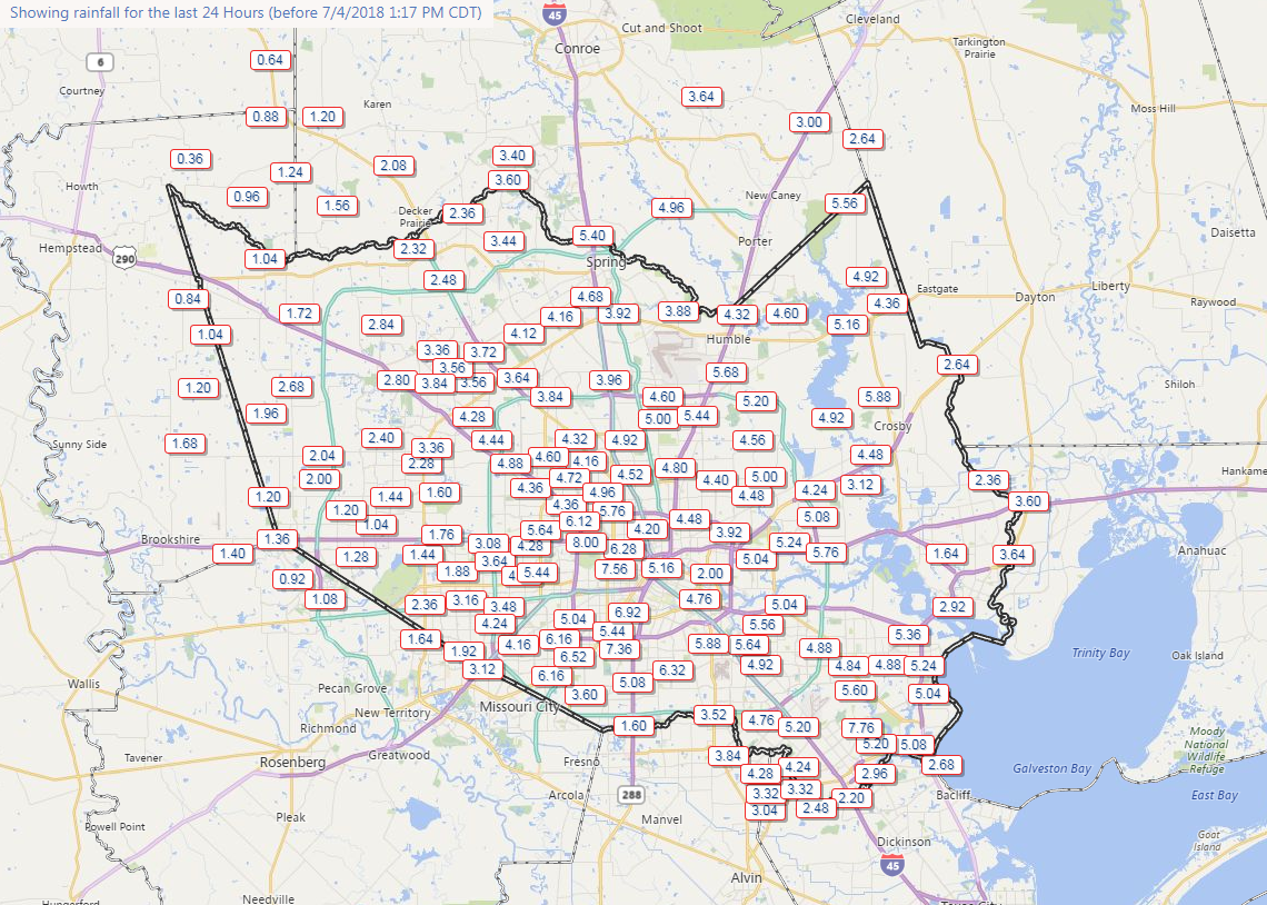
Total rainfall from this storm will top 8″ in parts of Houston, centered just west of downtown.
4-8″ of rain has fallen in much of central Houston, with 1-4″ surrounding the city, though with pockets of higher amounts south and east. (Harris County Flood Control)