Houston experienced fabulous January weather on Tuesday, and we’ll have a couple of more splendid days before conditions are mixed up a bit this weekend. This is the winter most of us in Houston know and love.
Wednesday and Thursday
Not much changes for the next couple of days, as we see pleasant, sunny days with high temperatures in the low 60s, and overnight lows on Wednesday around 40 degrees—warmer closer to the coast and cooler inland. Thursday night will be milder, as the onshore flow resumes, and moisture levels begin to rise.
After a series of colder nights, Friday morning’s lows will be more moderate. (Pivotal Weather)
Friday
Those rising moisture levels will generate some clouds on Friday, and possibly some light, scattered rain. Even so, the better rain chances probably don’t come until Friday night, when an upper atmospheric disturbance appears likely to move into the region from lower Texas. Highs Friday will probably reach into the mid-60s and you’ll begin to feel the humidity.
The first three weeks of January saw an average temperature about 7 degrees below normal across Houston, but the last week of the month should see weather more typical for this time of year—which is to say not too hot and not too cold.
Tuesday, Wednesday, and Thursday
After a chilly start this morning generally in the 30s across Houston, pleasant winter weather awaits. Under the influence of high pressure, we’re going to see mostly sunny days with high temperatures in the low 60s, dry air, and cool nights with lows in the low 40s—warmer at night along the coast and cooler for inland areas. Clear skies should make for really nice sunrises and sunsets.
Thursday night, Friday and Saturday
By later on Thursday, an onshore flow should resume, and this will increase cloud cover and return some rain chances to the area. Basically, the combination of warm, and moist air will generate some light, probably mostly misty rainfall later on Friday, Friday night, and Saturday across the area. In terms of accumulation, we’re probably talking at most a tenth of an inch of rain, or two.
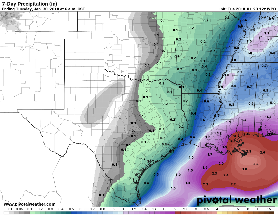
NOAA’s rain accumulation forecast through Saturday night shows only modest amounts for Houston. (Pivotal Weather)
Despite the mostly cloudy skies, due to warm air moving back in from the coast we’ll see highs near 70 on Friday, and probably at or above 70 on Saturday. The rain won’t be continuous, and some areas probably won’t get wet, but it won’t be the best start to the weekend.
Sunday
A cold front will push into Houston this weekend, and right now the most likely time seems to be between midnight and sunrise on Sunday, although this timing remains subject to some change. Most likely we’ll see a fast-moving, broken line of showers with the front. Conditions don’t look too blustery in the wake of the front’s passage, with perhaps 10- to 15-mph winds on Sunday as cooler air moves in to limit highs into the 60s. Sunny skies should return quickly, too. There’s some question about the strength of the front, but I suspect there will be enough cooler air to keep us in the 60s (highs) and 40s (lows) regime for the first half of next week. Rain chances fall off with the front’s passage, too.
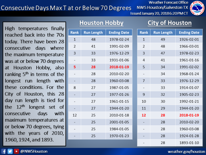
After four weeks of often-times very cold weather, high temperatures on Sunday broke into the 70s on Sunday. According to the National Weather Service, that is the 5th longest streak on record of sub-70 degree days for Houston’s Hobby Airport, and 12th longest for the city of Houston overall. The last time this occurred was 2010. Certainly, it represented the depth of winter for the region this year.
(National Weather Service)
Monday
A cool front moved through Houston early on Monday, generally bringing from one-tenth to one-half inch of rain to the area. Skies will clear out this morning, and we’re going to have an exceptional day with high temperatures of about 70 degrees. Overnight lows will drop to around 40 for inland areas, and 50 degrees along the coast.
Tuesday, Wednesday, and Thursday
Drier, mostly sunny weather will persist through much of the week as high pressure settles over the region. Days will be pleasant, with highs somewhere in the mid-60s, and overnight lows again around 40 degrees for inland areas, and 50 along the coast. Our modest northerly winds will shift from the north to east, and then southeast by Thursday, which should allow humidity levels to gradually rise.
Today’s the day. Yesterday was more of a false start than anything. We had a modest cloud deck that just setup shop overhead on Thursday, causing temperatures to stay in the 30s all afternoon once more. Today, regardless of clouds, we will finally leave the frigid weather behind this afternoon. But that does come with some rain chances.
Today
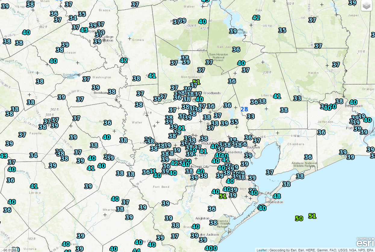
It’s starting off cold once again this morning, but not nearly like we’ve seen. Officially, we didn’t get below the mid-30s overnight. And the entire region is pretty uniform this morning, averaging between 35 and 40 degrees as of 6 AM.
A very uniform temperature map in Southeast Texas, with mid-30s to around 40° in most spots. (NOAA/NWS)
Clouds are firmly entrenched over the area, which has helped keep temperatures above freezing just about everywhere. These clouds will continue to hold firm today. Meanwhile, a system off the coast will bring scattered showers to the area through the day. El Campo and Bay City are already seeing some of that this morning. They will spread north as the morning goes on. The odds for rain will diminish as you head north and west of Houston however. So in this scenario, rain is more likely in League City than, say, Hempstead. Included with the rain will be a slight chance for thunderstorms near the coast. Nothing serious, but don’t be shocked if you hear some thunder in Galveston or south toward Matagorda Bay.
Rainfall amounts should average about a quarter of an inch south of I-10 and east of US-59 south of Houston. A few isolated spots could see a half-inch or so. North and west of Houston, most areas will see a tenth of an inch, give or take through Saturday morning. Temperatures today will need some encouragement, but they should top off in the lower or middle 50s by later this afternoon.
Weekend
Saturday should feature mostly cloudy skies with a slight shower chance. Most of us probably stay dry Saturday, but there could be a brief shower at virtually any point during the day anywhere in the region. That chance continues Saturday night and it may increase a bit during the day Sunday. On Sunday night, a cold front will sweep through the region, bringing a short period of showers and a chance of thunderstorms, especially along and north of I-10. Total precipitation this weekend will vary, averaging around a quarter to half-inch of rain in most spots; some could see a bit more, some a bit less.
But break out the shorts, as temperatures will feel downright warm (only being half sarcastic). Look for Saturday morning to start in the low-50s, warming into the upper-60s to around 70° Saturday afternoon, maybe even a bit warmer in spots. Sunday starts in the upper-50s to low-60s and warms into the lower or middle 70s!

