After a nasty line of storms moved through, clear skies ahead for Houston

Summary: After early morning thunderstorms, some of which produced severe straight-line winds, calmer weather is moving into Houston. We’ll see mostly sunny weather later this morning, and that will last well into Saturday at least. The next couple of nights will also be chilly—something that will not last much longer this spring.

Overnight storms

Well, did those storms wake anyone else up? The line hit my neighborhood shortly after 4 am CT, and we have significant tree damage as a result. For a few minutes it was pandemonium as a core of very strong winds reached the surface. According to the National Weather Service there were no indications of tornadoes in the Houston metro area. However there were significant winds accompanying the line of storms, with some gusts reaching 60 to 80 mph.

This cloud loop, ending shortly before 6 am CT, shows the progression of storms on Wednesday morning. (NOAA)

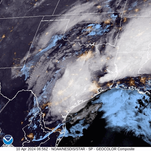
Reports are already rolling in from places as varied as Katy and San Leon of building damage and downed power lines. The good news is that the worst has now passed, and we’ll have several days of much more calm weather to clean up the mess. Additionally, the region picked up some much needed rain with warmer days ahead, and the likelihood of no meaningful precipitation for the next week or so. Most of the area picked up 1 to 3 inches of rain, but a few outliers picked up 4 inches overnight.

Wednesday

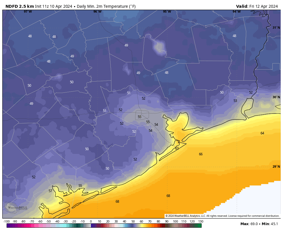
As of 6 am CT the strongest line of storms has already reached Beaumont, leaving light rain in its wake in Houston. This rain, too, should end by 7 or 8 am this morning at the latest, and we’ll see northwesterly winds as a front moves into the region. Skies will begin clearing before noon, and afterward we’ll clear out completely. Highs will be in the upper 70s today. The only note of concern is that beginning around noon, and lasting for about 24 hours, we’ll see a fairly stiff north-northwest wind. At times these winds may gust up to 30 or 35 mph. This is the price of drier air in April. Lows tonight will drop into the upper 50s.

Thursday

Aside from the aforementioned winds, which should start subsiding in the afternoon or early evening, this will be a splendid day. Skies will be sunny, with ample dry air. Highs will reach about 80 degrees. Lows will drop into the low- to mid-50s, with cooler conditions for outlying areas. As I’ve been saying, this is likely to be one of our last truly chilly nights of the spring, so if that’s your jam, I suggest you be jamming.

Low temperature forecast for Friday morning. (Weather Bell)

Friday

Another stellar day. This time, there will be no wind concerns. Skies will be sunny, with highs of around 80 degrees. There will still be plenty of dry air, but with the resumption of an onshore flow that will begin to change. Lows on Friday night will drop to around 60 degrees.

Saturday and Sunday

The weekend looks fine for outdoor plans. Saturday will be partly to mostly sunny, with a high of around 80 degrees. Humidity will be rising, but it won’t really start to feel humid until Sunday. There will be a few more clouds during the back half of the weekend, but highs will still manage to reach the low- to mid-80s. By Sunday night our lows will only be dropping to around 70 degrees.

Next week

Most of next week looks warm, with highs in the mid-80s perhaps, and a mix of sunshine and clouds. We’ll see a fairly continuous, robust southerly breeze. It will feel humid outside, but certainly not the kind of humidity we’re used to feeling later in the summer months. The next front looks like it may be about 10 days away.

Our confidence is increasing in severe storms early Wednesday morning

Summary: Much of the area is likely to see a line of intense thunderstorms move through early on Wednesday morning. We’re most concerned about the potential for damaging winds, hail, and tornadoes.

We’ve seen more data today that supports the development of severe storms early on Wednesday morning, including an unstable atmosphere and the kind of shear that promotes strong thunderstorms. There’s more one might say in meteorological terms, but the bottom line is that there is a lot of potential energy in the atmosphere waiting to be released.

That will happen overnight, as a surface front advances across Texas. This will produce a line of storms moving from west to east across the Houston metro area. In terms of timing, I expect the line to move across Houston approximately between 3am and 7am CT. These will be progressive storms, so although the rainfall is likely to be intense, it should pass fairly quickly. Most areas are likely to pick up 1 to 2 inches, but there could be higher isolated totals.

The tornado threat tonight is greatest to the northeast of Houston. (NOAA)

The biggest risk is not from flooding, but rather is likely to come from the threat of damaging straight-line winds, large hail, and tornadoes. Not all areas will see these effects, of course. But the majority of the area will see a period of strong winds and intense lighting and thunder. The greatest risk of severe thunderstorms is north of Interstate 10, but the models have been trending toward effects south of that boundary as well, perhaps almost all the way to the coast. In short, be prepared to be awoken tonight.

The majority of our guidance suggests that the storms pass to the east of the metro area by 7am or 8am on Wednesday, hopefully clearing out before the peak of the morning rush hour. But please be aware that some effects, such as low-lying street flooding, may persist. Skies should clear out pretty quickly as the front arrives, with drier air. Thus the rest of Wednesday looks breezy, but with no weather concerns.

Severe storms likely tonight ahead of a cold front on Wednesday

Summary: The atmospheric setup looks favorable for severe weather after midnight tonight, especially for the northern half of the Houston metro area. It’s the kind of night when you may well be awoken by thunder and lightning, and heavy rain. After this, a front sweeps through on Wednesday to bring us some of last truly chilly air of the season.

Tuesday

It’s a warm morning, and the Houston-area radar is fairly quiet. We are likely to see some showers today, with the possibility of a few thunderstorms mainly north of Interstate 10. However, it now appears as though the threat of stronger thunderstorms will wait until late Tuesday night into Wednesday morning. We may see a bit of sunshine later this morning, but skies will turn mostly cloudy this afternoon, and this should help to limit high temperatures to the low 80s. Winds will be gusty from the south-southeast, at times exceeding 30 mph.

There is an enhanced risk of severe weather Tuesday night for the northern half of the Houston metro area. (NOAA)

Tuesday night into Wednesday morning

A surface front associated with an upper-level system will spur the development of widespread showers and thunderstorms overnight. Although the details are not yet entirely clear, it appears as though a mass of storms will congeal to the west of Houston sometime after midnight, and move through the metro area between 2 am and 8 am on Wednesday morning.

The overall environment is favorable for strong to severe thunderstorms, with plenty of atmospheric lift and convective energy. Generally, the potential for severe weather will be higher north of Interstate 10, but the entire metro area is at some risk for storms. What does that mean? It’s the usual mix of threats in Houston: Damaging winds, large hail, and tornadoes. These storms will also produce heavy rainfall, so some locations could quickly pick up 1 to 4 inches of rain, briefly flooding streets.

On our scale of excitable dogs, I expect tonight to be an 8 out of 10, as these storms wake our furry friends.

Wednesday

The worst of the weather should clear the area, from west to east, by around sunrise or shortly afterward. Winds will turn westerly, and I expect clearing skies by late morning. Highs will be in the upper 70s, and later in the day it will turn increasingly breezy. Northwesterly winds will likely gust up to 30 mph or higher through the overnight hours. Lows will drop into the 50s in Houston with the influx of drier air.

Thursday

This will be a lovely spring day. Expect dry air, with highs in the upper 70s. Winds will die down a bit, with some gusts still reaching 20 mph. Thursday night will likely be the coldest of the week, with lows dropping into the low- to mid-50s. This may be the coldest night until late September or October, in fact.

Friday morning will dawn with a distinct chill. (Weather Bell)

Friday

A sunny, calm day with light winds. Expect highs in the upper 70s, and lows a few degrees warmer than Thursday night. This will be the last day with really dry air.

Saturday and Sunday

The weekend will see a warming trend, with a mix of sunshine and clouds. Expect highs in the low 80s on both days, with increasing levels of humidity—although nothing too crazy. Southerly winds will be breezy, with gusts perhaps on the order of 20 or 25 mph. But overall, it will be a mild spring-like weekend in Houston. Plan outdoor activities with confidence.

Next week

While the details remain fuzzy, most of next week should be fairly warm and humid. Expect highs in the mid- to possibly upper-80s, with warm nights in the 70s. We’re still going to see some more fronts this season, but they’re no longer going to arrive with any regularity. So it goes in April.

Clouds will eclipse the eclipse; then it will rain with maybe some storms

Summary: We’ll see mostly cloudy skies today with a chance of storms. The risk is higher north of Houston, so please take that into account if you’re chasing the total solar eclipse. Tuesday should be stormy in Houston ahead of a front on Wednesday morning. After that we’re sunny and cooler for a few days.

A bummer of an eclipse, with some storms

A total solar eclipse is the most spectacular astronomical event that most people will experience in their lifetime, and today offered a golden opportunity for people living in Texas. Unfortunately, much of the state will be socked in by clouds, from South Texas through Central Texas along the path of totality. It is possible that some areas of north Texas, particularly north of Interstate 20, will see a break in the clouds during the early afternoon hours to view totality. But even that is no certain thing.

Severe storm outlook for Monday and Monday night. (NOAA)

On top of this there is the potential for severe weather this afternoon and evening in central and northern Texas. This is likely to occur after the eclipse. However, if you’re traveling back to Houston late this afternoon or evening it is possible you will experience some severe weather. The primary threat today is hail, but some tornadoes are also possible. Again, this severe weather is less likely to occur in Houston, but if you’re traveling north of the metro area please be weather aware this afternoon, evening, and tonight.

Monday

Houston’s air has plenty of moisture today, and with a disturbed atmosphere overhead we’re going to see some scattered showers and thunderstorms. Skies will be mostly cloudy, so your chances of seeing a partial eclipse here are not great.

In Houston the Moon begins to move in front of the Sun at 12:19 pm, and will reach its maximum coverage at 1:40 pm CT. At that time, in the city, 94 percent of the Sun will be covered by the Moon. The event will end at 3:01 pm. Despite the mostly overcast skies, we may seen enough breaks in the clouds to briefly view the partial eclipse. You must wear eclipse glasses when looking directly at the Sun.

Scattered showers will be most likely in central and southern Houston this morning before lifting north, with the potential for stronger storms in Montgomery County and points north this afternoon and evening. Highs, otherwise, will be near 80 degrees in Houston today with humid air and, at times, gusty southerly winds. Rain chances should be lower tonight before resuming early Tuesday morning.

Tuesday

At this point it appears as though the chance of severe weather in the Houston metro area will be greater on Tuesday, perhaps with an initial round of pre-dawn storms moving in from the southwest, and another system later in the day or overnight. The potential for severe weather will be greatest for areas north of Interstate 10, but all of the area will be at risk for damaging winds, hail, and possibly a tornado. This threat will likely extend into the early hours of Wednesday morning.

Severe storm outlook for Tuesday and Tuesday night. (NOAA)

Aside from the potential for thunderstorms, this will be another warm and muggy day, with mostly cloudy skies and highs around 80 degrees. Winds will again be breezy from the southeast. Lows on Tuesday night will likely only drop to around 70 degrees.

Wednesday

Finally, on Wednesday, a decently strong front will surge into the area. I’m not super confident in the details, but this is likely to result in a final line of showers and thunderstorms early on Wednesday, followed by northwesterly winds and much drier air. Skies are likely to begin clearing during the late morning or early afternoon hours on Wednesday. Highs will again reach 80 degrees, but with lower humidity. Lows on Wednesday night should drop into the upper 50s.

Thursday and Friday

These look like a pair of fine, sunny days with highs in the upper 70s to 80 degrees, and ample dry air. Lows will drop into the upper 50s to about 60 degrees. It’s a damn shame we cannot delay the solar eclipse a few days.

Saturday, Sunday, and beyond

The weekend will be a little warmer, and a little more humid, with a fair amount of sunshine and highs in the low 80s. At this point I don’t see much of a signal for rain. Next week looks warmer and muggy, with highs in the mid-80s, or possibly even upper-80s. It’s a sign that, in the not too distant future, we’ll transition from spring into summer.