Congratulations to the Houston Astros, the 2017 World Series Champions. This was the team the city of Houston needed after Hurricane Harvey to help lift us up. And what was particularly poignant to me was the final score on Wednesday night, 5 to 1. Hurricane Harvey dropped 51 inches. It’s almost as if this victory was meant to be.
Although Houston just won the Fall Classic, it’s not going to feel much like fall outside. Both Thursday and Friday will see high temperatures in the low to mid-80s, under partly to mostly cloudy skies, and very warm nights in the low 70s. A few stray showers are possible on Thursday and Friday, but they should not last too long, and accumulations should be slight.
For thousands of Houston area residents, the aftermath of Hurricane Harvey remains a day-to-day grind as repairs continue on damaged homes. For others, memories of the storm are receding as fall finally descends upon Houston. As a reminder for those still recovering from the storm, our sponsor, Reliant, offers home repair services, backup generators and even home security. This month’s post about Reliant, however, will discuss the area of water filtration and plumbing.
Water Filtration
Water filtration service.
You drink water, bathe in it, and use it to wash your clothes and dishes. You deserve water that’s clean, safe and refreshing. Although the city of Houston, and other regional providers, offer safe, clean water there are additional options for further water purification. Reliant typically recommends and offers a whole home filtration with a salt-free water softening system.
Why consider this? These systems are eco-friendly, don’t waste water, don’t use electricity and don’t discharge anything into the environment. Water filtration systems can normally be installed in one day, either indoors or outdoors.
System options can include:
Water softening: part of a whole-home filtration system, water softening can extend the life of appliances, like your water heater or dish washer, by preventing scale, corrosion, excess chlorine and other harmful agents
Compact filtration systems: if whole-home filtration isn’t right for your residence, you can still enjoy clean, healthy drinking water with a compact system that filters water at the point-of-entry to the home
Advanced options: Water-heater shields, UV and reverse osmosis systems, salt- and maintenance-free
All water purification systems installed by Reliant are backed by manufacturer warranties and maintained by Reliant’s trained professional team.
Following a wet Halloween night and soggy start to Wednesday, Houston should dry out some later today as a storm system moves off to the east of the region. However, we cannot rule out a few lingering storms this morning for central parts of the area, and into the early afternoon hours for the eastern side of the metro area, including the slight possibility of a tornado. After today, rain chances fall, and Houston warms quite a bit for early November.
Wednesday
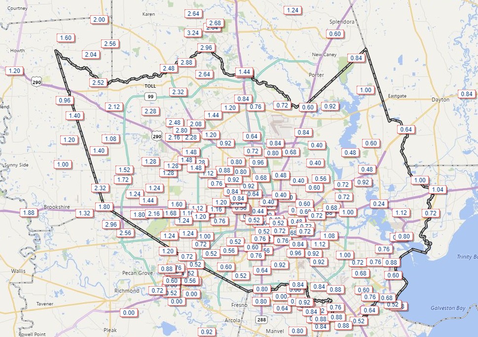
As anticipated, about 0.5 to 2.5 inches of rain fell across the Houston region, but fortunately we did not see any of the really heavy rainfall that might cause street flooding—or worse.
Rainfall accumulation from 6am Tuesday to 6am Wednesday. (Harris County OEM)
The stalled front and associated instability will move off to the east today, and I expect rains to end in Houston by or before noon. But for areas to the east of Interstate 45 we can’t rule out a tornado today given the potential for some rotation. Any twisters that do form should be short-lived. Highs should reach about 80 degrees for most of Houston, with a correspondingly warm night.
It’s much warmer this morning across the Houston area, as humidity and higher temperatures return and will stay for a while. This southerly flow in combination with a weak, stalled cold front will lead to some pretty healthy rain chances later today, tonight, and Wednesday morning. It’s nothing we’re too concerned about, but it could put a damper on some Halloween escapades this evening.
Halloween and tonight
One of my least favorite things about fall weather in Houston is the stalling front—a cool front with just enough oomph to make it into the Houston area, but essentially stalls or fizzles out near the coast. This creates favorable conditions for rain (and sometimes thunderstorms) but no lasting cooling. Alas, that is what we will see today, as moisture moves back in from the Gulf of Mexico and meets the unstable air from the front.
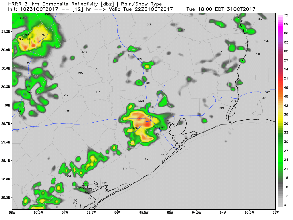
I think we’re going to see mostly light to moderate, scattered rain showers for this morning, with the added possibility of a few scattered thunderstorms this afternoon. Rain chances increase this evening—right around trick-or-treating time—and then really pick up later tonight and into Wednesday morning. For the most part I’d guess we’re looking at 1.5 to 2.5 inches of rainfall, but areas near the stalled front where heavier showers develop could see 4 or more inches over time. I don’t think we’re looking at flood concerns, because the rainfall rates don’t look particularly intense, but some areas could see steady rainfall for a number of hours that adds up.
This HRRR model forecast for radar activity at 5pm CT shows the potential for showers this evening. (Weather Bell)
My hope is that most neighborhoods can get enough dry time this evening between 6 and 8pm for trick or treating (no guarantees on that, sorry) and that we’re all inside celebrating an Astros World Series victory after the widespread, heavier rain arrives.