It’s hard to imagine a May week nicer than this in Houston

It’s a gorgeous morning across Houston, with lows generally in the mid-50s to low 60s. It feels wonderful, and we’ve got more of the same to come as high pressure builds over the region in the wake of Monday’s cold front.

TODAY

Words cannot really describe how wonderful today will feel. It’s probably the last, most spring-like day of the year until at least October. Partly to mostly cloudy skies this morning should give way to partly to mostly sunny skies this afternoon. Highs should only climb into the mid-70s. Temperatures will fall quickly into the 60s after sunset.
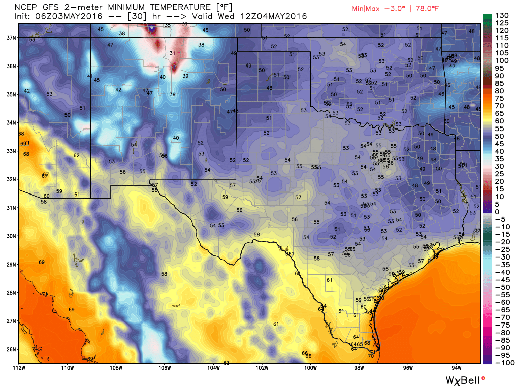
WEDNESDAY

Like highs on Tuesday, Wednesday morning will probably be our coolest morning until October as well. I could see temperatures falling into the upper 40s for some parts of Montgomery County, whereas most of the central and southern Houston area will be in the mid- to upper-50s.

Wednesday morning in Texas: Oh my. (Weather Bell)

See full post

May’s site sponsor: Texas Coastal Realty

Today I’m thrilled to announce the first monthly sponsor for Space City Weather: Texas Coastal Realty.

You may have noticed some changes to the site. I’ve removed all advertising, which should speed load times. There are also a few subtle indications of our monthly sponsor. In any case, Texas Coastal Realty is entirely responsible for bringing all of this site’s content to readers, for free and without advertisement, for the entire month of May. So if you appreciate that, and are looking for vacation rentals, or real estate along the Texas coast, I encourage you to consider them. You’ll be doing Space City Weather a favor!

For more information about the business and services they offer, please check out this page about our sponsor.

And if you’re interested in sponsoring Space City Weather we have a few months left for 2016.

Houston’s long slog through soggy weather to end soon—great weather awaits

Good morning. For part of the Houston area it’s been a stormy night, from Conroe northward late Sunday night, and from Pearland southward to Galveston early this morning (a coastal flood advisory is in effect until 11am CT). More than 2 inches of rain have fallen on the island during the overnight hours. Fortunately for most of Harris County, including the western parts of the metro region, we’ve seen scant rain during the overnight hours.

Houston radar at 5:55am CT. (Intellicast)


TODAY

Change is on the way. For the rest of the morning, with a moist airmass in place, we’ll see the continued threat of showers and thunderstorms across the area. However a merciful cold front should finally move through later today, and we should see an end to the heavy rain threat by around noon or shortly thereafter. Between sunrise and around noon there isn’t the potential for more than some minor street flooding to occur in Houston, and since the showers have generally remained to the south and north of the city of Houston, we can probably expect that trend to continue. The bottom line: This moist airmass is departing soon.

As our reward for all of this we’re about to see some glorious weather.

See full post

Storms to return to Southeast Texas today

While we’ve mostly gotten off easy here in Southeast Texas the last couple days, areas to our north and east have been pummeled by storms. The maps below show estimated rainfall for Friday into Saturday and Saturday into this morning.

Rainfall estimates since Friday show Northeast Texas and Louisiana have been clobbered. (NWS)

Areas in Northeast Texas saw tremendous rains Friday night, that unfortunately ended up being tragic in Palestine, TX. Yesterday morning and again this morning, the Lake Charles area was particularly hard hit as well, with totals of 6-8″ over a large area leading to widespread street and highway flooding.

So with all this in mind, today is a new day, and some changes will take place atmospherically that should lead to increasing storm chances.

See full post