In brief: We’re interrupting your Sunday with a short update to call attention to the possibility of severe weather this afternoon and evening. Most people should not be impacted, but some may well be. If it starts to thunder and lighting, take cover.
Happy first day of hurricane season, everyone. We don’t have any tropical concerns right now, and we’ll have more to say about the upcoming season tomorrow. For now, I just want to briefly butt into your Sunday to call attention to the possibility of strong thunderstorms later today.
Right up front I want to be clear that this forecast is uncertain. Although there are some elements in place for severe weather, including some decent wind shear and convective available potential energy, not everything is in alignment. It’s sort of like baking a cake and skipping the baking powder and substituting for the eggs, and popping it in the oven. You’re just not sure what’s going to happen.
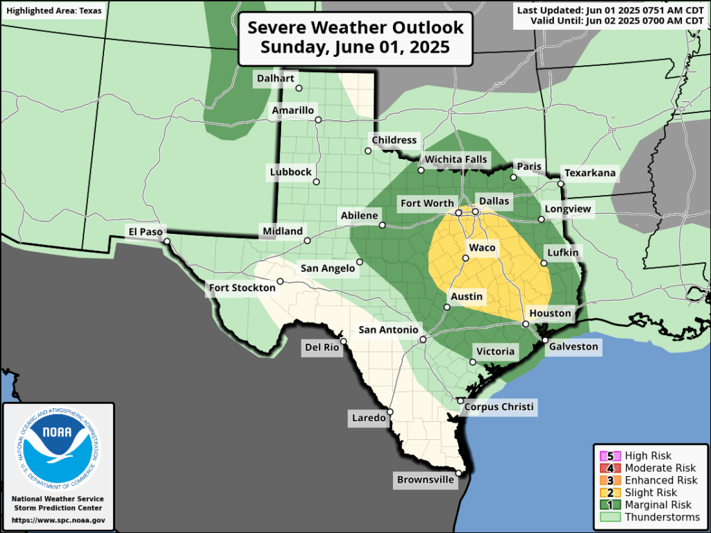
Severe weather outlook for Sunday and Sunday evening. (NOAA)
With that said, given the background conditions, there is the possibility of some strong and perhaps severe thunderstorms developing between mid-afternoon today and this evening. There are the usual threats here: briefly heavy rainfall, decently sized hail, and damaging winds. We also cannot entirely rule out a tornado, but the likelihood is low. Overall, the chances of severe weather are modestly higher north of Interstate 10.
Mostly, we are probably going to see mostly sunny skies this afternoon, with high temperatures in the low 90s. If you see storms, that’s probably going to be the exception rather than the rule. But the potential is there. Any inclement weather should calm down later this evening, and overnight. See you tomorrow morning with a full forecast.
In brief: A cluster of non-severe storms will impact southern parts of the Houston area primarily this morning. A few additional storms could fire, especially east of I-45 or at the coast later today. We’re also keeping tabs on a chance of storms Sunday, followed by standard June fare next week.
Today
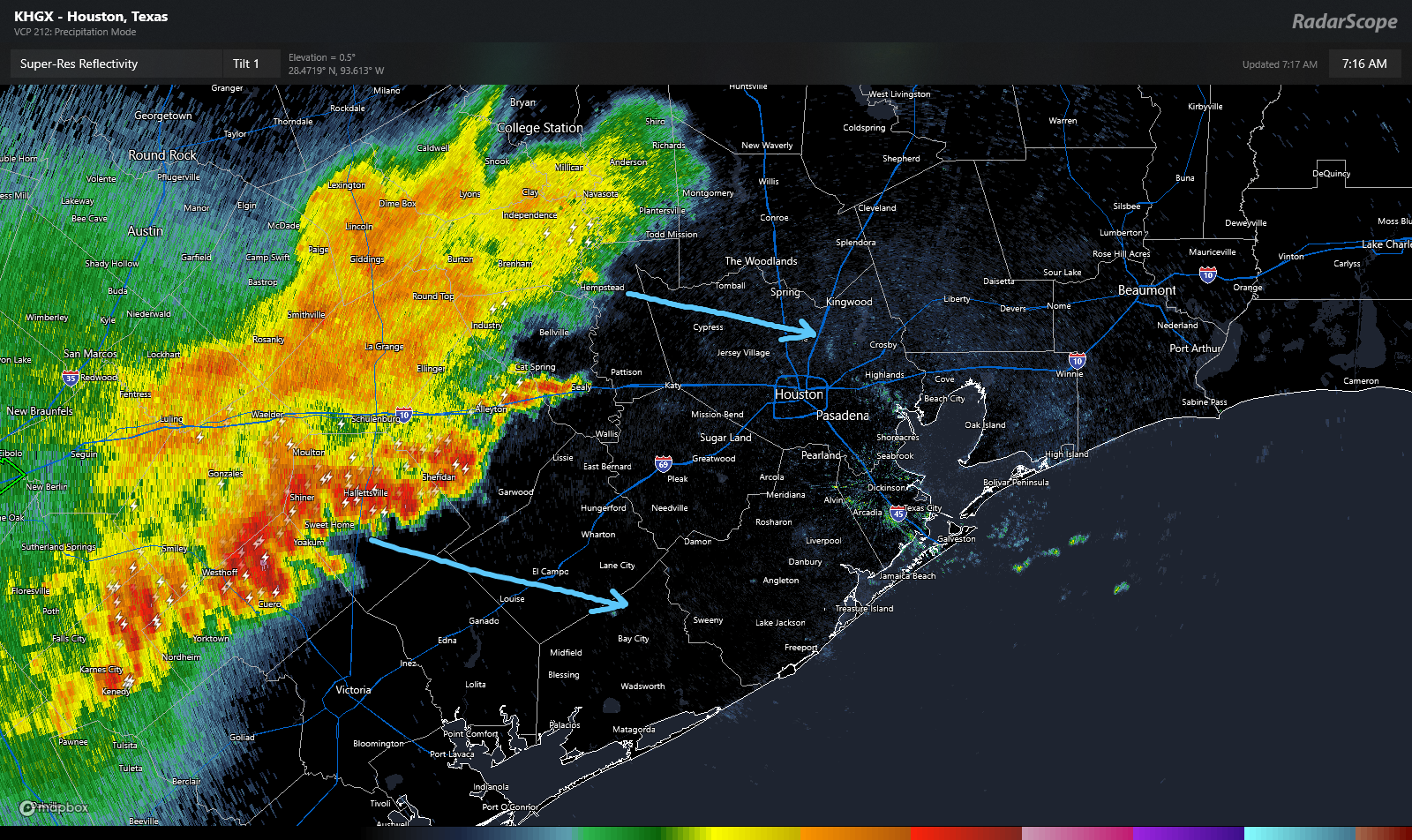
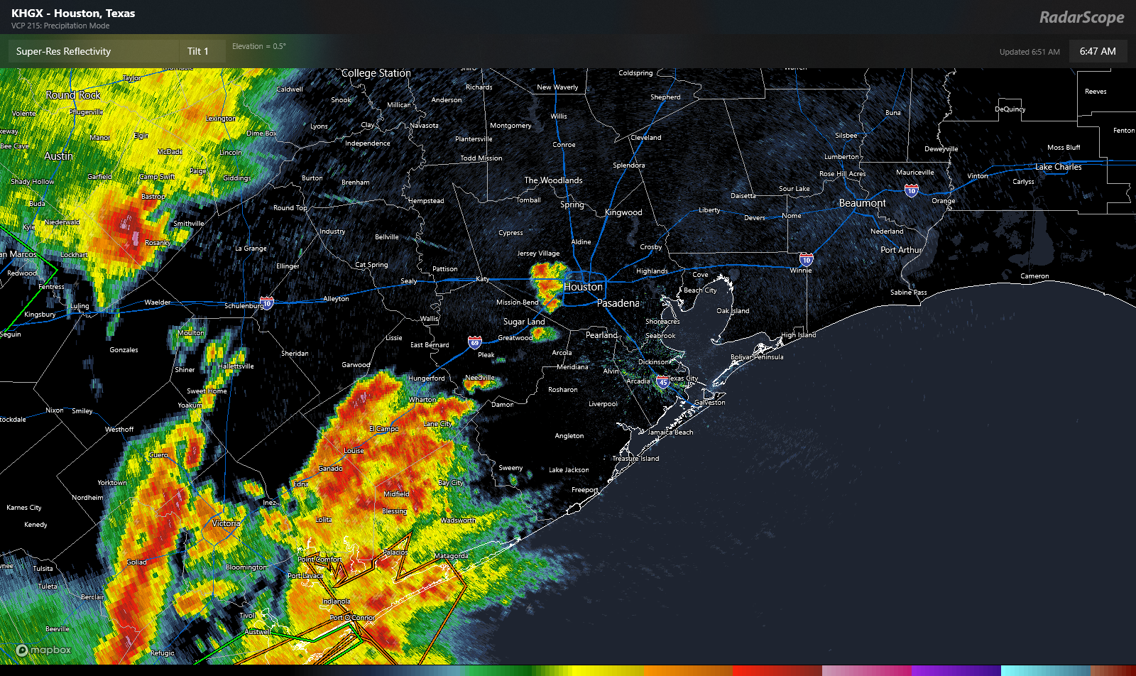
Another active radar this morning. It feels like it’s been this way a few times this week! Anyway, there is a complex of non-severe thunderstorms moving into the Sealy and Prairie View areas now. That will head into the rest of the Houston area, especially along and south of I-10 over the next few hours.
Radar at 7:15 AM shows thunderstorms moving toward Houston this morning, but they are non-severe. The heaviest action will go south of I-10. (RadarScope)
At this point, the storms are not severe, but they are producing heavy rain and lightning. Especially the southern part of the line, which is pushing through Shiner and moving toward El Campo. But other than the aforementioned rain and lightning, we don’t think these storms will cause significant problems.
What happens next? Models suggest this cluster of storms will weaken further as it approaches Houston. On the periphery, new storms may develop heading into afternoon. One or two of those storms could be on the stronger side, especially east of I-45 or along the coast. Outside of thunderstorms, expect some cloud cover at times. It’ll be warm with highs in the upper-80s.
Weekend
Tomorrow looks like it *may* be the quieter of the two weekend days. Expect an isolated shower or storm, but in general, the weather may behave much like we saw yesterday, where it’s mostly sun and clouds. Highs will be in the upper-80s to near 90 degrees.
Sunday is mildly more interesting. Models have been pretty consistent since yesterday in showing at least some kind of line of storms dropping in from the north during the late morning or afternoon. I don’t think that’ll be a big deal, but if you have outdoor plans Sunday just keep an eye on things. Otherwise, expect highs in the low-90s.
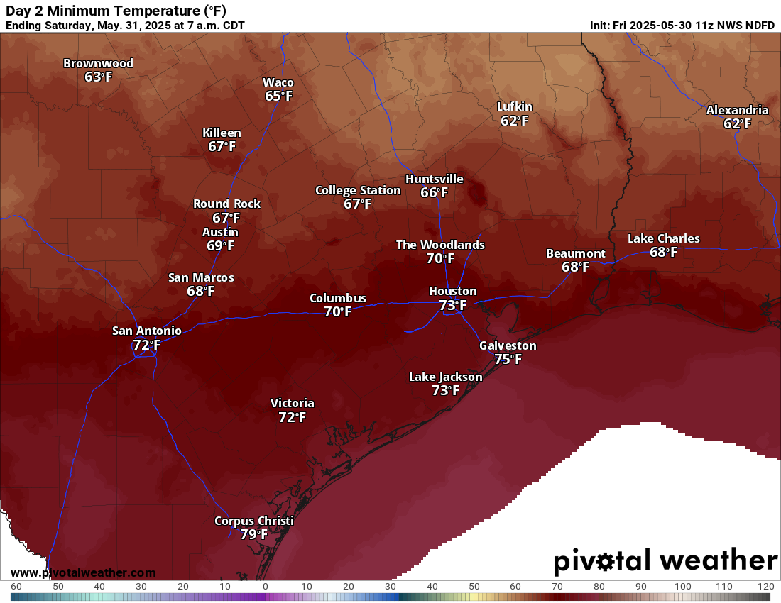
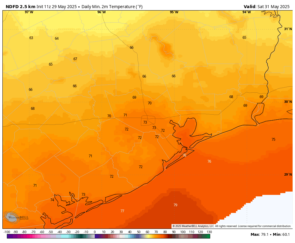
Saturday morning’s low temperatures won’t necessarily be refreshing, but they should be fairly comfortable for some outdoor yard work or a run. (Pivotal Weather)
Humidity this weekend will be (relatively) lower compared to where it has been, allowing morning lows to dip into the 60s in a couple spots and low-70s away from the coast.
Next week
We should settle into a very June-like pattern next week. There will be a handful of shower chances sprinkled in through the week, but no one day looks worse than the others right now. Most days should be partly to mostly sunny. High temperatures will be in the low-90s, with low temperatures in the mid to upper-70s. The odds of mid-90s will increase later in the week.
In brief: The Houston area has had a wet week, and by and large this has been beneficial for the region before the onset of summer and the lurking potential for drought. We have a final chance late tonight and on Friday as a weak front moves into the area, providing a spark for showers. After that we’ll see June-like weather as June begins.
Rain status
Houston has picked up some much needed precipitation this week, with a vast majority of the region picking up up 2 to 5 inches of rainfall as a series of disturbances have passed through. As rarely happens, for Houston at this time of year, the region got just enough rain rather than too much; with our soils receiving a good drenching without too many flooding issues. This week’s rains put us in a much better posture heading into the coming summer, drought-wise.
Our rain chances have not ended. The primary driver over the next 36 hours will be an advancing front that stalls near the coast on Friday, bringing some decent rain chances to areas along and south of Interstate 10, before pushing offshore. However, we don’t expect too much in the way of organized storm activity. Oh, and if you’re tired of the rain, after Friday conditions look mostly dry for at least the next week or so.
Thursday
Our weather today will be mostly sunny, with high temperatures this afternoon pushing up to around 90 degrees or a touch higher. Winds, generally, will be light. (If you like to go bike riding in the evening, this will be especially noticeable). I think it’s possible that we will see some isolated to scattered showers this afternoon, but for the most part the region should be rain-free. Lows tonight will be muggy, in the upper-70s for most locations.
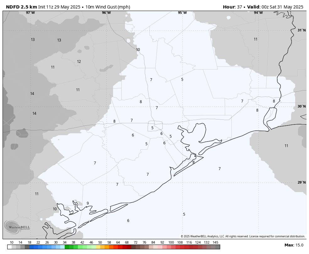
If you’re a fan of light winds, this evening may only see gusts of about 5 mph in the Houston area. This is a pretty stark contrast to what we’ve been seeing most of this spring. (Weather Bell)
Friday
On Thursday night a front will be pushing through Central Texas, and we could see a fairly strong line of showers and thunderstorms along the I-35 corridor advancing toward the Houston area. But as of now, I expect these storms to weaken some as they move down toward Houston. Still, I think the region will see a healthy possibility of some showers and thunderstorms on Friday morning, perhaps around sunrise or a bit later. We cannot rule out some hail and damaging winds with these storms, but overall odds seem fairly low.
As the front nears the coast it could stall, and thus for coastal counties we may see some lingering showers in the afternoon (or they may simply remain offshore). Skies will be partly to mostly cloudy on Friday, with light winds from the northwest. Highs will be around 90 degrees, with lows in the lower 70s.
Some inland areas may get lucky on Saturday morning and catch some low temperatures in the upper 60s. This will probably be the last time that happens until September. (Weather Bell)
Saturday
The front will usher in some briefly drier air. Don’t expect much, but humidity may be a tad lower on Saturday. Expect highs in the upper 80s with partly to mostly sunny skies. Lows on Saturday night may again drop into the lower 70s. Rain chances are near zero.
Sunday
Temperatures should reach around 90 degrees, or slightly above, with mostly sunny skies. We may see a few scattered showers during the afternoon as humidity levels recover some. Lows on Saunday night will drop into the mid-70s.
Next week
Most of next week should see mostly sunny skies with highs in the low 90s. We cannot rule out temperatures rising toward the mid-90s by the end of the week. However, conditions will feel fairly typical for June in Houston, which is to say hot and humid. Rain chances are low each day, but probably non-zero as a few areas may catch a stray shower.
In brief: Scattered to numerous storms will impact the Houston area once more today. Severe risks, while low are not zero. We’ll remain unsettled heading into the late week and weekend but hopefully at a less intense pace than we’ve started the week with. Hotter weather lurks on the horizon.
[UPDATE:We’re pulling the trigger on Stage 1 Flood Alert. See the details at the bottom of the post.]
Today
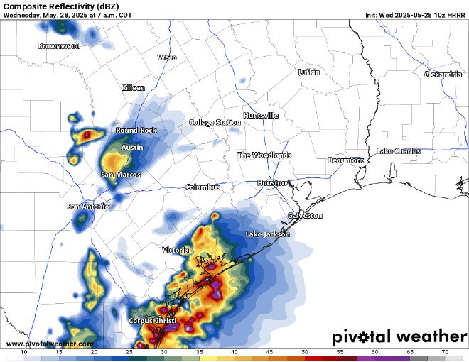
After things calmed down yesterday, they stayed calm, thankfully. We will not have that luxury today. Storms (non-severe) are already moving across Matagorda County and Wharton County this morning.
Radar at 6:45 AM shows heavy rain and thunderstorms near Matagorda Bay into Wharton County and a couple isolated showers or storms just west of Downtown. (RadarScope)
There are also a couple isolated storms just west of Downtown. Over the next few hours, the activity near Matagorda Bay will slide across Brazoria and Galveston Counties. Some of those storms could be strong to severe with gusty winds. Lightning and heavy rain are a given with these storms as well. Elsewhere, scattered storms will pop across the rest of the area today. While we don’t expect significant severe weather, we cannot rule out isolated severe storms. Gusty winds are the main concern today.
A radar forecast from 7 AM-11 PM today every 2 hours. This is generally how things could play out today. (Pivotal Weather)
It’s possible we see an additional cluster of storms develop with daytime heating out near College Station and the Brazos Valley. Those could swing through in the evening hours. Again, the primary concern would be isolated gusty wind as that happens.
Also keep an eye out for heavy rainfall. These storms are putting down close to 2 inch per hour rainfall rates. This could cause some street flooding to crop up in spots. Nothing too, too serious but just be mindful in typically flood-prone spots. Temperatures will be held back in the 80s today.
Thursday through Sunday
We may venture back to a somewhat less widespread coverage of storm chances here, with more sea breeze driven daily thunderstorms. Those tend to be less intense but can produce locally heavy rainfall. So all days should see the potential for a little street flooding in isolated spots. Many places would end up without much rain. One or two storms could be strong.
That said, we will want to keep tabs on what happens out in western Texas. We’ll be in a northwest flow aloft, as winds 20,000 feet up move from northwest to southeast across Texas. If any sort of complexes of storms can develop out west, they could end up nearby eventually. Models don’t do a great job predicting those features more than 18-36 hours out, so there’s certainly a tinge of uncertainty in the forecast. So with all that in mind, we don’t currently expect widespread storms but we’ll be babysitting the situation through the week.
Temperatures look to top out in the upper-80s on days with rain and low-90s on days without. Morning lows should generally be in the 70s.
Next week
A return to drier, hotter weather seems likely next week. High pressure may try to anchor over the Southeast or Gulf, which would keep Southeast Texas at least at the periphery of hot weather, with temperatures likely starting the week in the low 90s and moving upward from there.
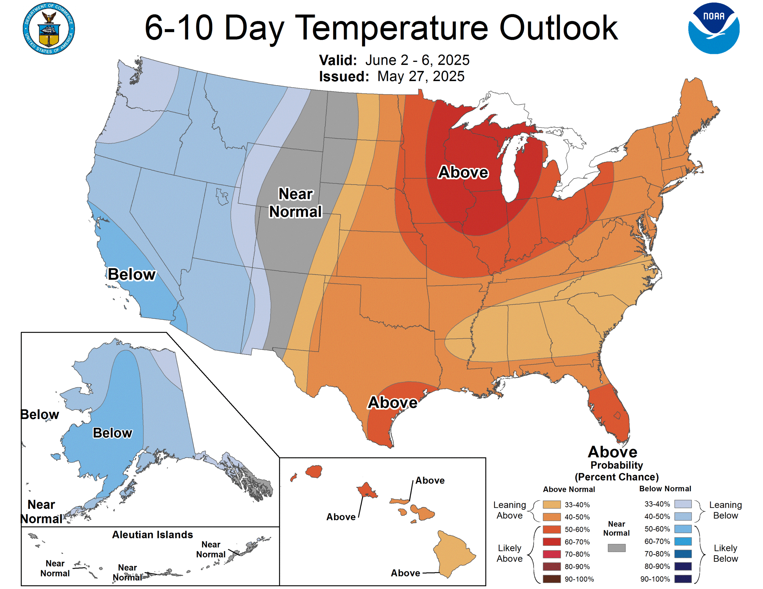
The 6-to-10-day outlook is hot across the Eastern U.S., including southeast Texas. (NOAA CPC)
Mid-90s will probably return at some point. Stay tuned.
Update: Storms this morning are producing localized torrential downpours with rates of 2-4 inches per hour that will cause heavy ponding and some street flooding in spots. As as result, we’re pulling the trigger on a Stage 1 alert on our Flood Scale.