The pendulum of weather this winter has been fierce and rather erratic at times. While not as extreme as what we saw in January, another strong shift of the pendulum is underway, back in the warmer direction.
Today & Weekend
We have an interesting variety of temperatures across the region this morning.
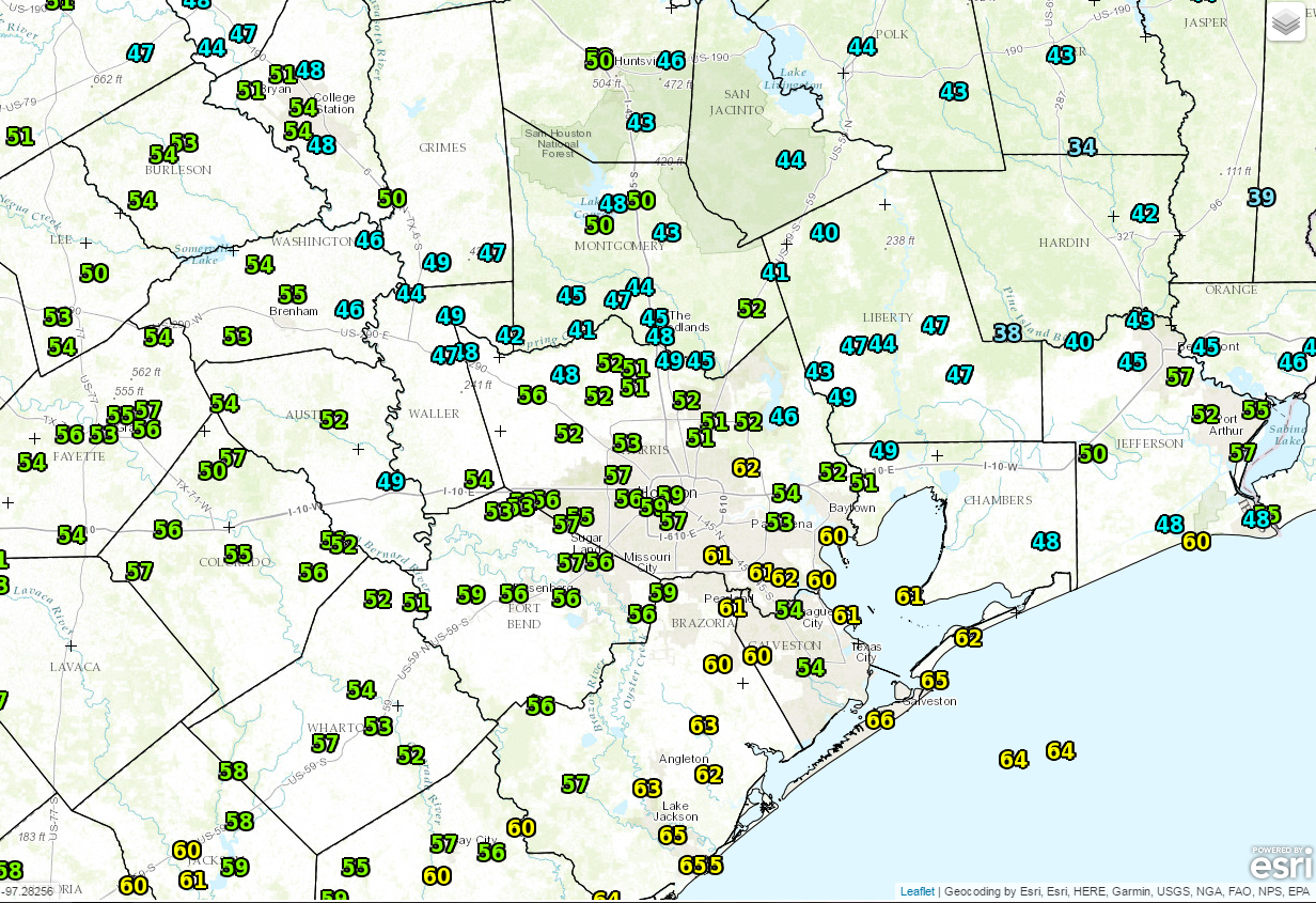
We have a band of low clouds oozing up from South Texas this morning, and that’s keeping places south of Houston mild. However, if you go north of the metro area, clear skies and light winds have allowed temperatures to drop into the 40s and a few 30s in ideally sheltered spots.
Low clouds should give way to a bit of sun, before new clouds arrive later today. There is a very slight chance of a shower or some light sprinkles, primarily south and west of Houston this afternoon.
The majority of the weekend should be problem-free. We will see clouds around, interspersed with sunshine. An isolated shower or a little light rain is possible but probably nothing you need to plan around.
Temps are going to surge again however. While it shouldn’t be quite as warm as we saw earlier this week, there is a good chance we see that Saturday and perhaps Sunday reach the 80 degree mark. As Eric pointed out earlier in the week, Houston is going to at least threaten the record of seventeen 80+ days in meteorological winter (December 1-February 28). We are at 14 now, and if Saturday and Sunday both hit 80°, we’ll be at 16 days. That will give us over half of February left to tie or break the record of 17 days. What’s winter?
No other issues this weekend, but watch for the potential of fog in spots, especially near the coast by Sunday.
(Space City Weather is sponsored this month by Darrell Lee’s The Gravitational Leap)
Next Week
The chance of showers ticks up a notch on Monday as a cold front approaches. Then, look for the front to come barreling through on Tuesday, bringing widespread rain and thunderstorms. Eric’s been talking about this for a few days and for the most part, nothing has changed. Expect an inch or two of rainfall on average across the area, with most of it falling in a 6-12 hour or so window Tuesday.
The usual Southeast Texas caveat that “higher amounts are possible” applies here however. We could see 2-5″ in a couple isolated spots where the rain & storms are most persistent. Behind the front, it looks sharply cooler, with highs in the 60s and lows in the 40s for at least a couple mornings. It will feel refreshing. We do warm back up into next weekend.
Posted at 6:35 AM by Matt
Record low of 52 degrees this morning – in my office. Somebody left the A/C running full blast all night.
Hey Matt! What are your thoughts on tonight’s full moon/eclipse/comet? What times will these phenomena be viewable from Galveston?
Will we have a good chance for clear skies for the eclipse?
Are you looking for severe weather with this front?