After a string of splendid weather, we’re heading back into the muggy warmth of mid-spring in Houston. We’ll cap it with some rain chances next week. Maybe we can finally wash away some of the pollen that has been driving some of us crazy. (raises hand) Let’s dive in.
Today through Sunday
The quick and dirty here is that if you have outdoor plans this weekend, you should be in good shape. There could be a few showers around, but for the most part, I feel fairly comfortable telling you that the weather will be quiet this weekend.
We have a few patchy low clouds around this morning that should dissipate. Expect new clouds to billow up at times today, but on the whole it looks fairly nice. Expect a little more humidity and high temperatures approaching 80 degrees.
I think Saturday and Sunday may play out similarly with nighttime through morning low clouds or a few sprinkles giving way to partial afternoon sunshine, fairly typical for Texas springtime. Again, there’s a very, very slight chance for a shower. But as Eric mentioned yesterday, a pretty firm capping inversion probably keeps us dry the vast majority of the weekend. Both Saturday and Sunday should see highs in the low 80s and morning lows struggling to get below the upper 60s.

Headed to the beach? Be aware that as onshore winds increase today and this weekend, so will the risk of rip currents. If you do decide to take a dip in the Gulf, please do so cautiously.

Monday
We probably get one more mostly quiet day on Monday. Expect a similar story to the weekend, with morning clouds giving way to some sunshine. High temperatures should again reach the low 80s after starting in the middle or upper 60s. You may notice winds pick up a bit again on Monday afternoon. Storm chances are not zero, but they are very low.
Tuesday through Thursday
Here’s where things begin to get more active. Onshore flow will become fairly strong Tuesday and Wednesday. If you’re planning an outing to Galveston or Surfside next week, you should be prepared for rough surf, and continue to be aware that rip currents will be on the strong side. Those onshore winds will likely keep temperatures from dropping below 70 in much of the area next Tuesday, and Wednesday mornings. A cold front will enter Texas and slowly drag its way across the region from northwest to southeast later Tuesday through Thursday.
What does this mean? It probably means a few showers and storms on Tuesday and more numerous thunderstorms on Wednesday. We may still have just enough of a cap in place around Houston on Tuesday to keep most activity to our north and west, but by Wednesday, I think the door opens up. Our models are gradually coming into some agreement beyond Wednesday now. I think the most likely scenario is that the cold front makes a clean pass through the region by Thursday afternoon or evening. We’ll then probably see a return to cooler and drier weather for Easter weekend.
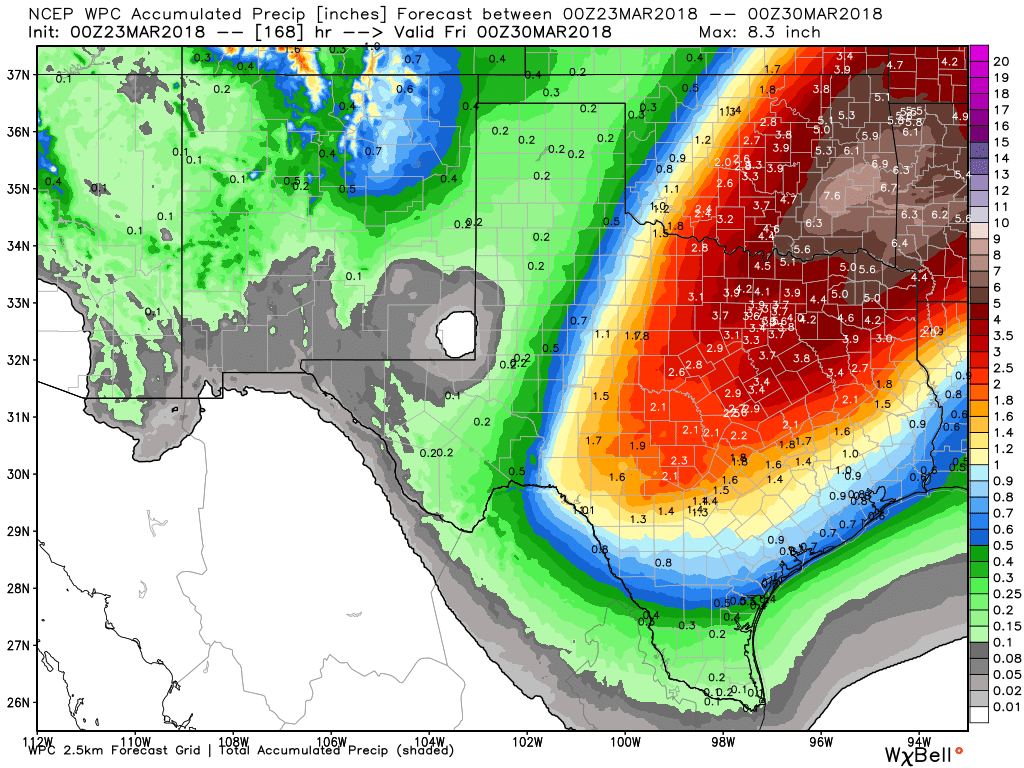
So the obvious question everyone will ask: Do we need to worry about any severe weather or serious flooding next week? Probably not. This looks pretty straightforward right now. The best dynamics for heavy rain are north of our area, with the heaviest rains likely focused from just north of College Station up through Texarkana, an area that has seen a good bit of rain in the last several weeks. For Houston and the surrounding area, as long as the front remains progressive and kicks through on Thursday, as we are expecting, we will be fine. But as always, it’s spring, so we’ll keep watching this closely and let you know if anything should change.
The weather pattern setup over North America continues to support anomalously cool weather. This means spring will probably continue to be delayed for our neighbors up north. Meanwhile, it should mean occasional periods of delightful weather here in Texas, punctuated at times by a few days of humidity. Enjoy those nicer days while we still have them!