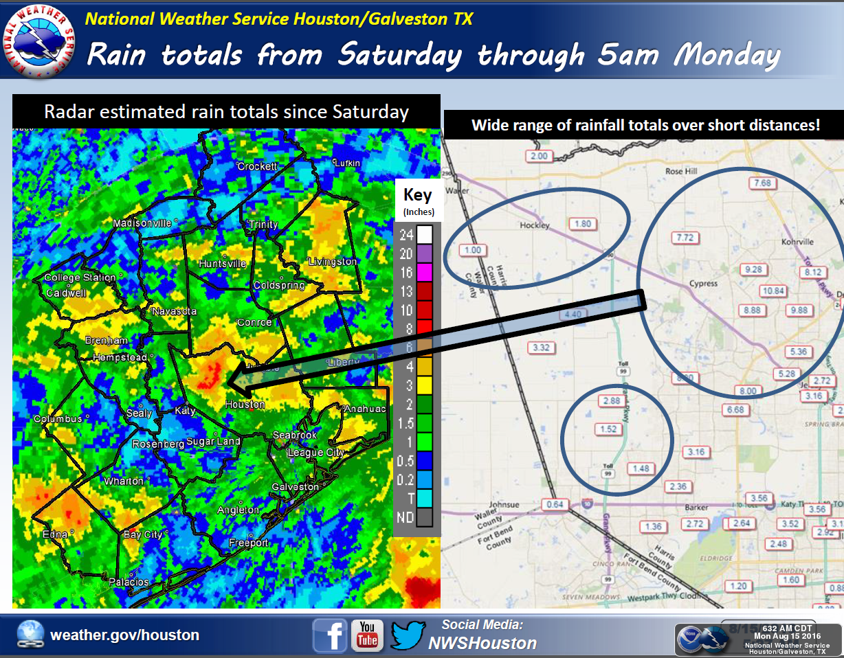
It’s been a soggy weekend for some parts of the greater Houston region. In northwest Harris County, the Cypress and Tomball area have received 7 to 11 inches of rain, bringing Cypress Creek to bank full—but thankfully not beyond. Other areas such as Jersey Village (6 to 8 inches), Livingston (4 to 6 inches), Wharton County (4 to 6 inches), and The Woodlands (4 to 5 inches) have all gotten a lot of rain since Saturday afternoon. At the same time, some parts of the metro area (such as Spring, not far from The Woodlands) have gotten almost no precipitation at all. Such is the nature of these storms. Here’s a full list of rain totals through Sunday evening.
The forecast
Put bluntly, more of the same lies ahead. For Texas, the heaviest rain showers during the overnight and early morning hours on Monday have come to the west of Houston, from El Campo to San Antonio and Austin. This is where some of the most moist air is meeting with lower pressures to create lift in the atmosphere.
I expect we’ll see shower and thunderstorm coverage fill in over the greater Houston metro area later this morning, and through the afternoon. It will probably be the same kind of pattern as Saturday and Sunday, whereby some parts of town see heavy storms, and a few miles away it’s dry outside. Today’s storms will certainly be capable of producing isolated rain totals of 3 to 6 inches. Areas that have already received several inches of rain, clearly, will be at a much higher risk for flooding than areas that have remained mostly dry so far. Accordingly, the greater Houston area will remain under a flash flood watch through at least 7pm this evening.
Beyond today
Absent a ridge of high pressure, and with Gulf of Mexico moisture steaming into the state, we’re likely to remain in this wet, cooler pattern (with highs generally in the upper 80s, and mostly cloudy skies) for most of this week. However it seems that slightly less moisture will be available as we get to the second half of the work week, meaning these very heavy, potentially flooding tropical rains area likely to become somewhat less frequent.
Higher pressures may reach the Houston area by Saturday or Sunday, possibly pushing daily rain chances below 50 percent. But clearly, at least for the middle of August, we’re going to see weather that is well below normal, temperature-wise, and much wetter than our often drought-like late summers. As long as we don’t see significant flooding, it’s hard to complain too much about that.
Tropics
Mid-August through late September is typically the most busy time of year for the western Gulf of Mexico. Due to a variety of factors the Atlantic basin has remained quiet since Hurricane Earl went into Mexico in early August. With several vigorous tropical waves having moved off Africa—or about to—I expect that to change fairly soon. We’re probably going to see at least two, or maybe even three, named storms develop before the end of this month. Whether any of them will progress westward and into the Gulf of Mexico, well, that’s anyone’s guess.
But it is that time of year.
Posted at 8:15am CT on Monday by Eric
I’m not sure why you said Spring has had hardly any precipitation at all. We’ve had over three inches of rain so far. Not near the total of other places but we have had hard rain at times.
Always my go-to source for Houston weather news. Thanks!