In brief: In this evening’s post we attempt to set some expectations for Tropical Storm Edouard as it nears the Texas coast. Will we see some impacts in Houston from this storm? Yes. Are they likely to be serious for most of us? Probably not.
Latest on Tropical Storm Edouard
As of 10 pm CT, Tropical Storm Edouard is moving to the west-northwest at 7 mph, and has sustained winds of 40 mph. Forecasters expect it to strengthen into a stronger tropical storm before landfall on Tuesday, likely during its final hours before landfall, or possibly even a Category 1 hurricane.
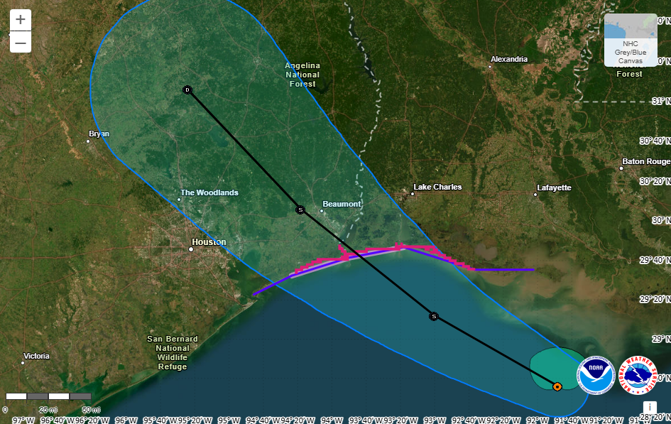
The center of Edouard is likely to come ashore near the Texas-Louisiana border at midday on Tuesday, and then it will move to the northwest, perhaps passing near Conroe or Huntsville on Tuesday night before dissipating south of Dallas.
Let’s bring the temperature down a little bit
Earlier today I made the mistake of checking out how Tropical Storm Edouard is being covered on social media and in the news locally here in Houston, and I saw a lot of “information” about how to prepare for the storm. The reality is, for most of us, no real preparations are needed. It is important to be informed and stay up on the forecasts, of course, but you don’t need to be out there stocking up on rations or hoarding cases of bottled water.
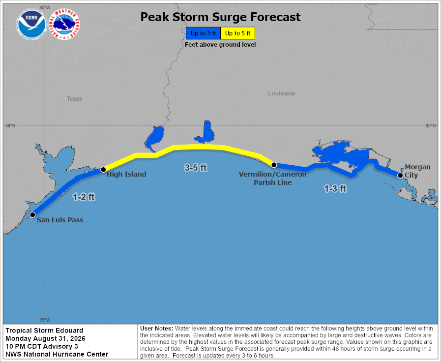
This storm will bring some moderately elevated winds, but nothing that should lead to widespread power outages in Houston or surrounding suburbs. Seas may be elevated a couple of feet right along the coast. And most notably, we’re going to see the potential for some heavy rainfall, but this should not be an extraordinary rainfall or flooding event. We foresee some impacts to streets and highways, and we’re going to talk about that. But this is not going to be some kind of super storm.
So here’s what to expect
Overall conditions should be fairly quiet tonight. We’ll see a few scattered showers and thunderstorms overnight into early Tuesday, but the bulk of the rains associated with Edouard remain well offshore. By around sunrise we may see some of the outer bands from the tropical storm reaching the upper Texas coast, in places like Galveston.
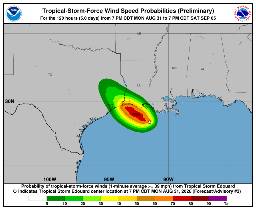
Winds will also start to pick up by mid-morning. For coastal locations, from High Island up to the Texas border with Louisiana it will be possible to see tropical-storm force winds, and a Tropical Storm Warning is in effect there. But the likelihood of such winds further south, along Galveston Island, is lower. Later on Tuesday areas along and east of Interstate 45, including up into Montgomery County, may see wind gusts of 30 to 35 mph. Most of the region should see gusts in the 20s, however. This will be a windy day, but not something super impactful in Houston.
In terms of rains, we still expect the heavier rains to fall just east (and possibly north) of Houston on Tuesday. We are maintaining a Stage 2 flood alert for areas along and east of Interstate 45, which means there is the potential for flash flooding in some locations, but that most of the area should be fine most of the time. It is important to be weather aware and exercise caution in heavy rainfall. Never drive into flooded roadways. A Stage 1 flood alert is in effect for areas west of I-45.
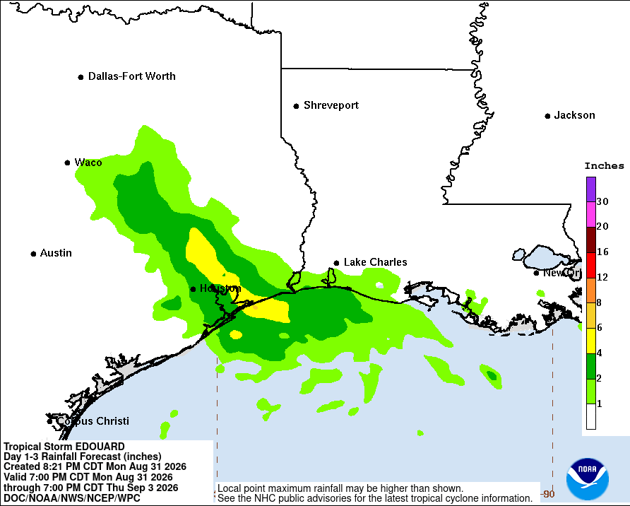
Overall we expect wide variations in rainfall—with some areas hit and other locations missing. For areas east of I-45, most locations will probably pick up 2 to 5 inches of rainfall, with higher bullseyes possible in locations such as Mont Belvieu and points east. For locations west of I-45, accumulations will likely be between 0.5 and 2 inches, with a few higher bullseyes. Areas northwest, west, and southwest of Houston, including Katy and Sugar Land, may see limited rainfall depending on the precise track of Edouard. This is probably not your storm.
Rain chances will be highest on Tuesday, but we could well see some wrap-around showers on Tuesday night and Wednesday. in the greater Houston region.
Our next update will come no later than 7 am CT on Tuesday.
