Storms are absolutely hauling their way into the Houston area tonight, faster than most of us expected earlier today. Good news, as you’ll see below. But they are intense. Rain is falling at a rate of 3 to 4 inches per hour on average in that intense red portion of the line bowing across Rosenberg, Cinco Ranch, and Cypress at 9:45 P.M.
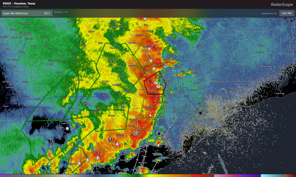
These types of rain rates will almost certainly produce street flooding across many parts of the region through Midnight, spreading east and south.
In addition, there have been multiple tornado warnings issued with these storms, including one storm that may have well produced a tornado just north of Brookshire earlier. Stay alert and aware, and seek shelter if a tornado warning is issued in your area. As of this writing, there is a tornado warning for the northwest side of the city through 10:15 P.M. Even with no tornado, strong, damaging winds are possible.
So, some good news about all this at least: That the storms are moving quickly is positive because, while it’s going to rain much of tonight, the super-intense, “floody” 2 to 4+ inch per hour rates will be short-lived over a given area. We can manage a steady rain. It’s when you get that overly intense stuff for more than an hour or two that things get out of hand.
Beyond tonight? Truthfully, I don’t have a great feel on what to expect tomorrow at this point. I think some of that will depend on how these storms evolve over the next several hours, and what happens back to our west overnight. Some models redevelop storms in parts of the area. Others give us a nice break between storm chances. It’s a tough call right now, so you’ll need to be fairly flexible and adjust with the forecast tomorrow. We do know that there will be more storms, but how intense and exactly where they hit matters a lot, and we just aren’t sure yet.
Eric will have an update on what’s happening here after midnight tonight.
Thank you for your clear reports! I am so glad for some good news! Harvey trauma triggered as my home is in a flood prone area.
Newbie here. Daughter clued us in to SCW. Sure glad we did. We are between Rosenberg and Cinco Ranch – the bottom fell out @ 2145.
Thanks fellows for sticking with us! The Houston alert and warning to take shelter because of possible tornado says Houston region whereas you at least give us some idea on location of the threat.
You’re a saint!! I’ve been frantically refreshing my facebook like a lunatic, waiting for this post. Thank you for everything you do. You’ll forever be the only weather source I trust, and I’ll continue recommending you guys to everyone I know. Stay safe and dry! ♥️
You guys are literally the best. Thanks so much for always keeping us informed and staying on top of things in a hype free way. Appreciate all the long hours you guys put in!
“Eric will have an update on what’s happening here after midnight tonight.” This tugs at my heart, you guys. THE BEST.
Love the reporting, thank you.
I would like to know more about the direction given in the tweet accompanying this post to seek shelter in an interior room.
That is extremely good advice in the event of a tornado, but I worry that it was too broadly casted in this instance. I recognize that it’s easy for me to say that after local warning has expired and the worst of the storm seems to have passed, hence my query.
Winding down here in the Champions area. Not as bad as I feared. Winds didn’t get very strong; power still on. Not a ton of rain either, 0.80 inches and raining lightly now.
Thank you guys
No power here in LaPorte..
Love you and Matt, Eric! Appreciate your commitment to this vast community.
And BTW, folks admire my SCW t-shirt. 🙂