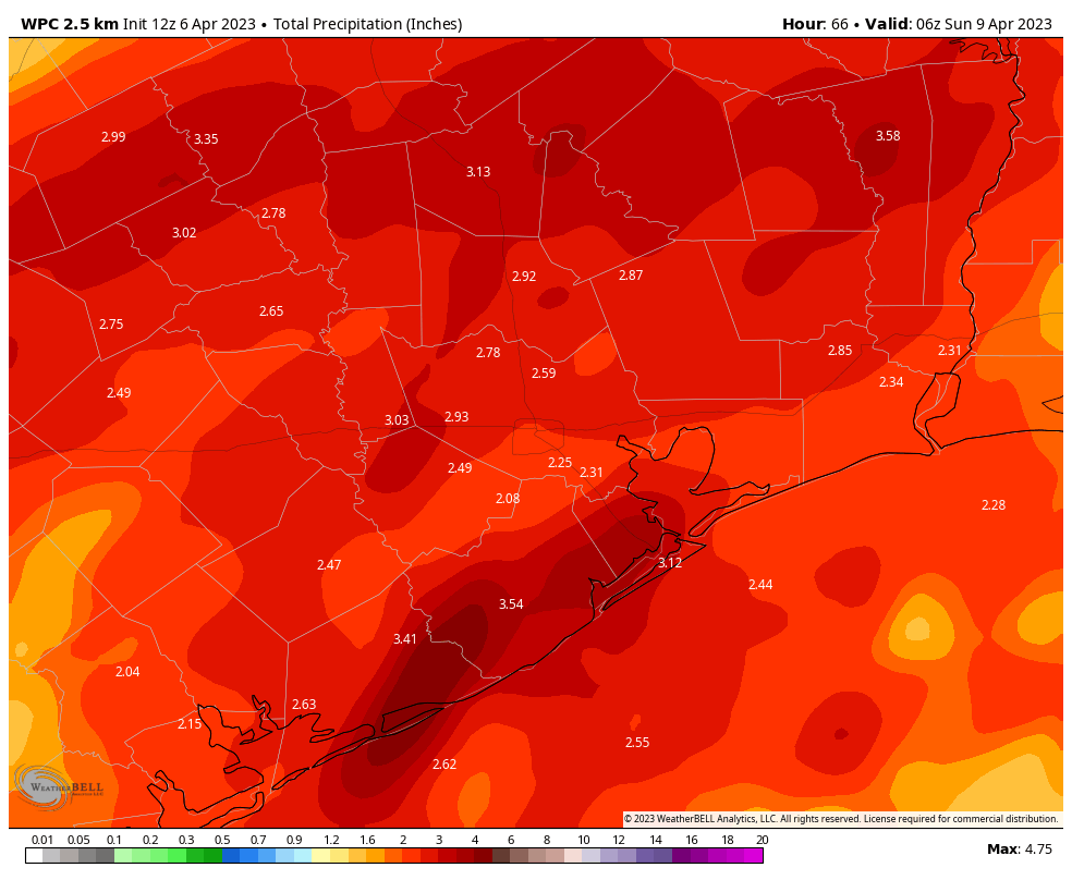
Good morning. The Houston region saw a burst of rainfall on Wednesday and Wednesday night, with widely varying totals. Some areas saw only a few tenths of an inch of rain, whereas parts of northwestern Montgomery County have recorded as much as 4 inches of rainfall. The Houston area will remain in a wet pattern through Friday before we dry out this weekend. Easter Sunday looks pleasant, with partly sunny skies and highs in the upper 70s.
Thursday
The focus for rainfall this morning lies to the northwest of Houston, where a boundary just above the surface has remained more or less stationary. This area, including Austin, Waller, Washington, Brazos, Grimes, and Montgomery counties, will remain the focus for on-and-off shower activity this morning. Much of the Houston metro area may well remain rain-free during daytime hours today.
Later this afternoon and overnight, however, we are likely to see showers and thunderstorms developing closer to the coast, in and south of Houston. Overall accumulations today and tonight for the region are likely between 0.5 and 3 inches of rainfall. I think our Stage 1 flood alert covers things nicely. As always, remain weather aware when heavy rainfall threatens, and check conditions before venturing out.

Aside from precipitation, expect cloudy skies today with high temperatures in the upper 60s. Winds will be out of the northeast at about 10 mph, with higher gusts. Winds will pick up tonight, perhaps gusting up to 30 or 35 mph. Low temperatures will drop to around 60 degrees, or maybe a few degrees lower.
Friday
Healthy rain chances continue overnight and into Friday, as a wet airmass remains in place, with the destabilizing presence of a cold front just offshore. This activity should start to wind down on Friday night, or Saturday morning at the latest. All told, most of the region will see an additional 1 to 4 inches of rainfall through Friday night. Please take care in thunderstorms, and do not drive into high water. High temperatures on Friday may only reach the low to mid-60s, with continued mostly cloudy skies. Lows on Friday night will drop into the upper 50s.
Saturday
Rain showers should come to an end late Friday night, but we can expect clouds to persist for awhile. Highs on Saturday will be around 70 degrees, with moderate northerly winds at 10 to 15 mph. With dewpoints in the upper 50s, the air will feel reasonably dry. Lows on Saturday night will drop to around 60 degrees in Houston.
Sunday
Conditions on Easter Sunday look nice. We should see partly sunny skies during the late morning and afternoon hours, with highs pushing up into the upper 70s. There will be enough dry air for it to feel pretty pleasant outside. Lows on Sunday night will likely drop into the low 60s.
Next week
Most of next week looks spring-like as well. Our highs look to be around 80 degrees, with nights in the 50s and 60s, and at least a modicum of drier air. A weak front may arrive on Tuesday-ish to provide a bit of slightly cooler weather. It does look like we’ll warm up some before next weekend, perhaps into the mid-80s. We shall see!


— quote —
The Houston region saw a burst of rainfall on Thursday and Thursday night,
— end —
It’s just now early Thur morning. (7:14am).
Beat me to it, mt.
Could it be that SCW has achieved time travel, and Eric is writing this on Friday?
Thank you for the detailed report but I was surprised that this morning there was no mention of last night’s hail. That is the worst hail I have ever driven through.
There was no hail in the metro. And not much rain either. Heavy sigh…not surprised it wasn’t mentioned if it was only in your area.
Gee, I feel so left out. What is the boundary of the metro area? Loop 610? Beltway 8? I live just west of Beltway 8, a few blocks south of I-10, and we had violent hail. I didn’t have the courage to gather some for the freezer.
I was driving in Houston through George Bush Park when it started and continued through my drive to Katy.
PS I guess I consider the “metro” to be the inner loop. 610. All the hot air rising from the concrete tends to keep it dry. Not much land for garden stuff. So we live for spring rain. Been in a drought for the last 3 years except maybe 2021.
The “metro” area is an actual official thing, and is much bigger than the inner loop.
https://www.houston.org/houston-data/houston-metropolitan-statistical-area-profile
We’re on the Westside near Greenhouse and I had a 2 inch piece of hail in my front yard. It was intense!
At least it isn’t over 90 degrees outside today.
Amen!
Thanks for all of the good analysis and reporting. In the NOAA Excessive Rainfall map today, the names of cities are almost unreadable. Maybe you can’t change the font, but if you can, I suggest that you switch from an outline font to a solid one. I have a good computer setup and good vision, and I had to almost double the size of the map to read “Austin.” I understand that the purpose of the map is to show areas and not particular cities, but still . . . . . .
Don’t know if he’s new or not but new to me guy on KTRK was saying up to 12 inches yesterday and now he’s saying 6”-8” in Houston today/tonight. They used to be better than most at not exaggerating weather news, but Allen is not like the others. Why SCWx is so great, just the facts.
They are able to get away with it when they use specific terms like “up to” “possible” “current models” as examples. They can argue that we reported what the current data models showed,but now todays models shows different prediction.
Hope to get some rain in Sweeny where I live. So far we have only had 0.01 inches if rain since yesterday. There are big cracks opening up all over my yard due to the dry year we’ve had so far.