What’s that you say? We haven’t had an SCW Q&A since April? Well, as they used to say in that old Wolf Brand Chili commercial, that’s too long!
In this installment, we tackle your questions about “classic” Houston summer weather, fall front enthusiasm, variable houmidity, whether a slow hurricane season means more intense storm next year, and tropical storm directions. Got a question of your own, drop it in our contact form!
Q. I moved to Houston in 1995 and have lived here ever since. My memory from when I moved here is that summer days typically were hot, but that we often a short period of thunder and rain in the afternoon. My recollection is that this pattern was the ‘norm’ that was to be expected during the peak of the summer. We don’t seem to see that pattern so much now? I would be interested in your observations on this. Thanks for the great work you do, I have recommended SCW to so many people!
A: In my 14 years in Houston, I have heard this a lot. In fact, I remember last summer when people were quite pleasantly surprised by the seemingly daily storms, calling it almost a “throwback” summer. But do the numbers bear that out?
Well, in Houston it’s tough to truly measure the typical daily storms because, as everyone likes to joke, it can be raining on one side of the street and not the other. So what’s the best way to look at this statistically? Let’s start by look at the number of days in the summer months (which I’ll define as May through September) where rain occurs. We’ll look at both Hobby and Bush (which has an added record of threaded data back to 1950 for the “Houston area.”)
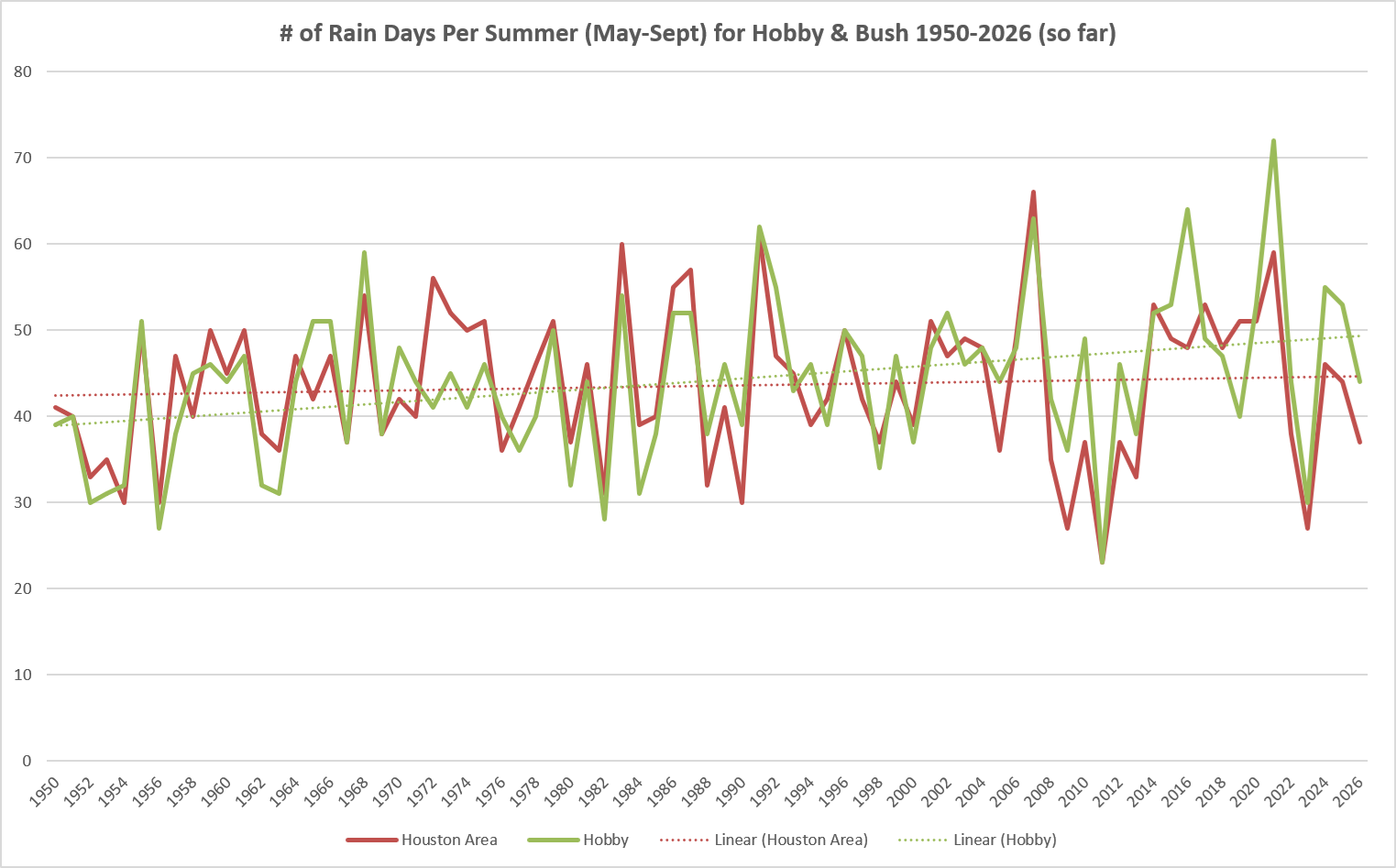
A couple things stand out. First, you can see some of the drought years for sure. You also see those mid-2010s years where Houston got blasted. But, both trendlines are upward pointing, Hobby more so than Bush. This means we’re seeing more rain days, sort of.
If we shave off 1950-1969 and just run both 1970 through 2025 (since 2026 isn’t over), where both airports were operating together, there’s actually a slight downward trendline at Bush. I also shaved off May and changed the threshold to a “trace” of rain because we really don’t get into the “daily storm” pattern until sometime in June typically and nearby storms often produce trace amounts of rainfall.
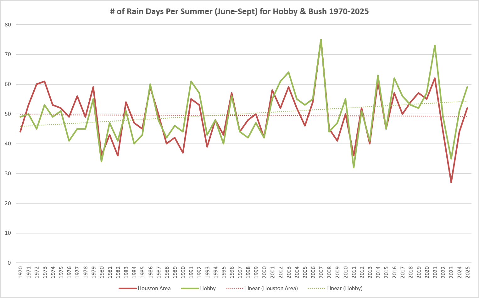
What I suspect is happening? There could be a degree of variability here with some areas turning wetter with time and others less so. As the Gulf has warmed in the last 20 years or so, we may be seeing a different pattern of daily storms as the sea breeze comes in each day. Obviously, these are untested hypotheses, but it is interesting to see that sort of differential compared to the longer-term record.
–Matt
Q. Eric, it seems like your enthusiasm for the years first front has waned compared to previous years. I may be jumping the gun and maybe you don’t start talking about them until mid September, but it concerns me. Do you know something that I and the little more than average lover of meteorology don’t?
A. If readers know one thing about me, it’s that I love a good fall cool front. We started Fall Day at Space City Weather to celebrate this very thing! However, I’m also rather wary of over-promising and under-delivering on cool fronts when it comes to our readers. So I’m not going to mention the possibility of something happening unless I think there’s at least a decent chance of it happening.
Anyway, my general rule is to not even utter the words “cool” and “front” together on the website until after Labor Day because August fronts are super rare. Well, we’ve just gotten past Labor Day. And happily, some of our models are showing the possibility of a front toward the end of next week. Rest assured you can expect daily updates on this, the most important of Houston news at this time of year.
-Eric
Q: Even when there is a lot of humidity (houmidity?) in the forecast, it always seems to drop some in the afternoon, but at night it goes back up through the morning. Why?
A: For this, you have to look at two variables. Remember, relative humidity, which you see usually labeled on the news or in your app as just “humidity” (or houmidity) is a relative measurement of humidity. Relative to what? The moisture (water vapor) in the air relative to the maximum amount of moisture it can hold.
There’s a number of ways to think about this, but the I find that the easiest is to think about air temperature and dewpoint. Dewpoint is the temperature that the air would need to cool to to reach saturation. We also know that the warmer the air, the more moisture it can hold. During the day, the amount of moisture in the atmosphere isn’t changing a ton. Sure, dewpoints may drop from something like 76 in the morning to 70 in the afternoon. But what else happens during the day? It heats up. Let’s take a recent non-rain day, August 30, as an example.
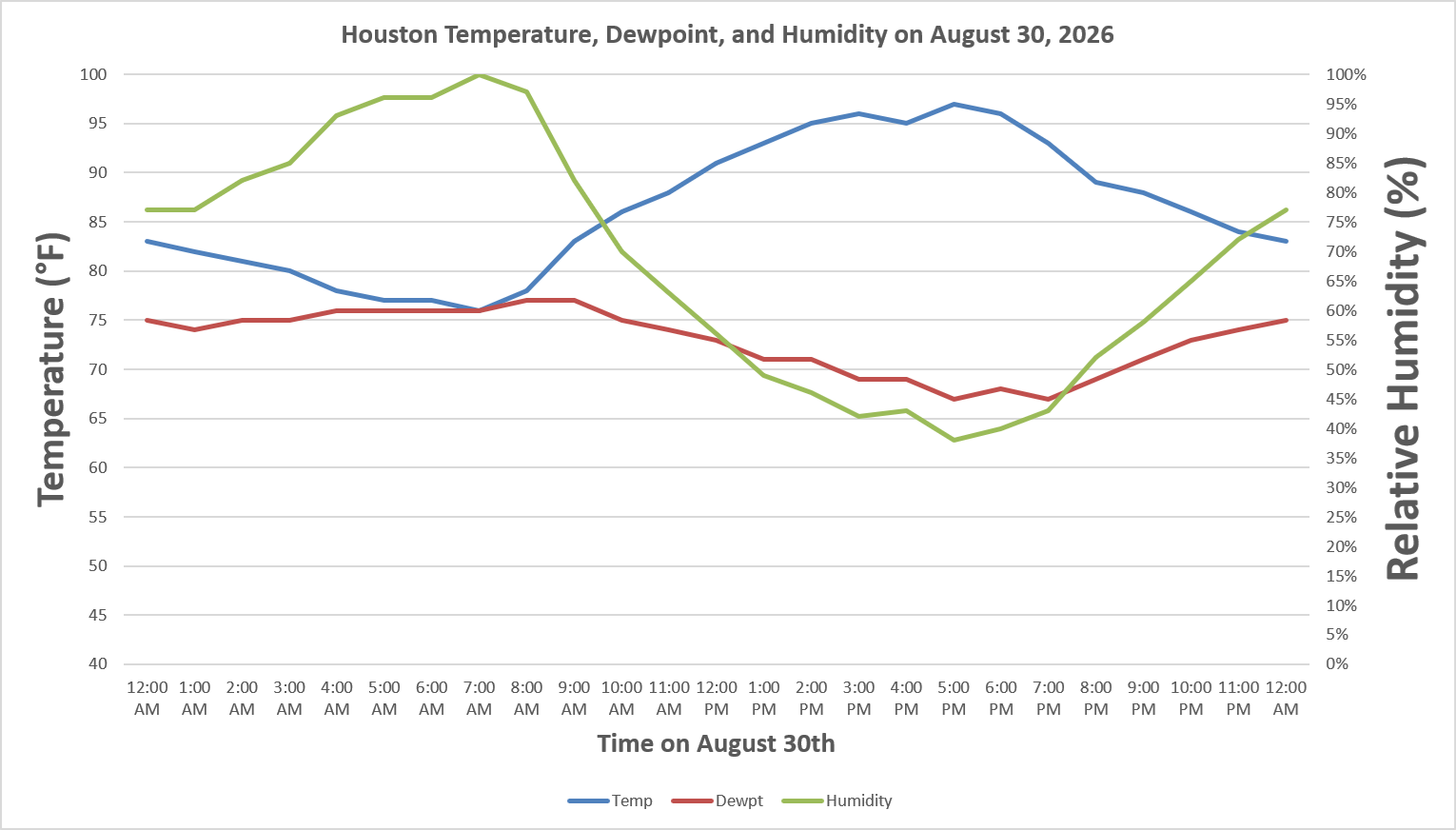
On August 30th, you can see how dewpoint was pretty steady more of the day, with minimal variability. As temperatures began warming, just after 7 AM, the relative humidity began to drop. Humidity was its lowest at the hottest point in the day. Then, after sunset, as temperatures cooled closer to the dewpoint, the relative humidity began to shoot upwards again. This is one reason why we argue that dewpoint is generally a superior metric to relative humidity for determining comfort. I don’t think we’d call it comfortable at 5 PM, but the air is holding less moisture, relative to the morning hours. So there’s your lesson on humidity!
-Matt
Q: Very happy that, so far, hurricane season has mostly been a bust for us. Keep it that way. I know that storms can cool down oceans as they churn cooler water to the surface. Does a slow hurricane season mean the oceans stay hot and the next year’s season could be more severe?
A: The simple answer is no. The more complex answer is that while hurricanes do help redistribute warmer air from the tropics to the poles and do churn up subsurface cooler water when they pass (upwelling), this is generally a temporary and localized effect. What will dictate the subsequent hurricane season’s activity and water temperatures is more related to larger scale patterns across the tropical basin of the Atlantic or global influences (like El Niño). The tendency is to move onto the next season, but at this point, it’s tough to say anything meaningful about the 2027 hurricane season, and I would not worry about “paying” for a quieter season this year. Variability is the norm.
-Matt
Q. Both tropical storms Bertha and Edouardo seemed to follow the same path this year, headed west along the upper Gulf coast and into SE Texas. Is this east-to-west path unusual, or even unusual to happen twice in one season.
A. It is rather odd that in a quiet Atlantic hurricane year, three of the five named storms have decided to visit the upper Texas coast. That’s a very high strike rate, and we can be grateful that, some flooding issues aside, these were non-stalling storms that did not turn into hurricanes.
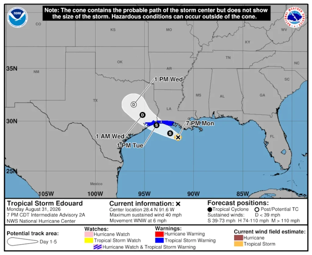
As for their movement, what we observed is not overly unusual. Tropical storms tend to move from east to west in the latitudes of the Gulf, and will do so until they find a weakness in high pressure to their north. Once they do so they will indeed move north, and then become pulled northeast as they reach the mid-latitudes and are influenced by winds known as “westerlies” which, perhaps not surprisingly, blow from west to east.
-Eric
