It’s quite warm, in the mid-70s, and muggy across Houston as we reach the midpoint of September. The radar is also dry, but that won’t last too long with tropical moisture looming offshore.
Thursday
Most of the moisture isn’t going to arrive just yet, and enough lingering high pressure should limit showers and thunderstorms today, especially for inland areas. I’d only expect scattered to isolated storms, with highs around 90 degrees.
Friday through Monday
You may have noticed that the National Hurricane Center has started to track a blob of tropical moisture that is moving toward the Texas coast. Due to significant wind shear this system is highly unlikely to develop into a depression or tropical storm, but Galveston and other coastal regions should nonetheless see some effects, such as stronger than normal waves and tides 2 to 3 feet above normal levels. Rain chances will also be highest along the coast.
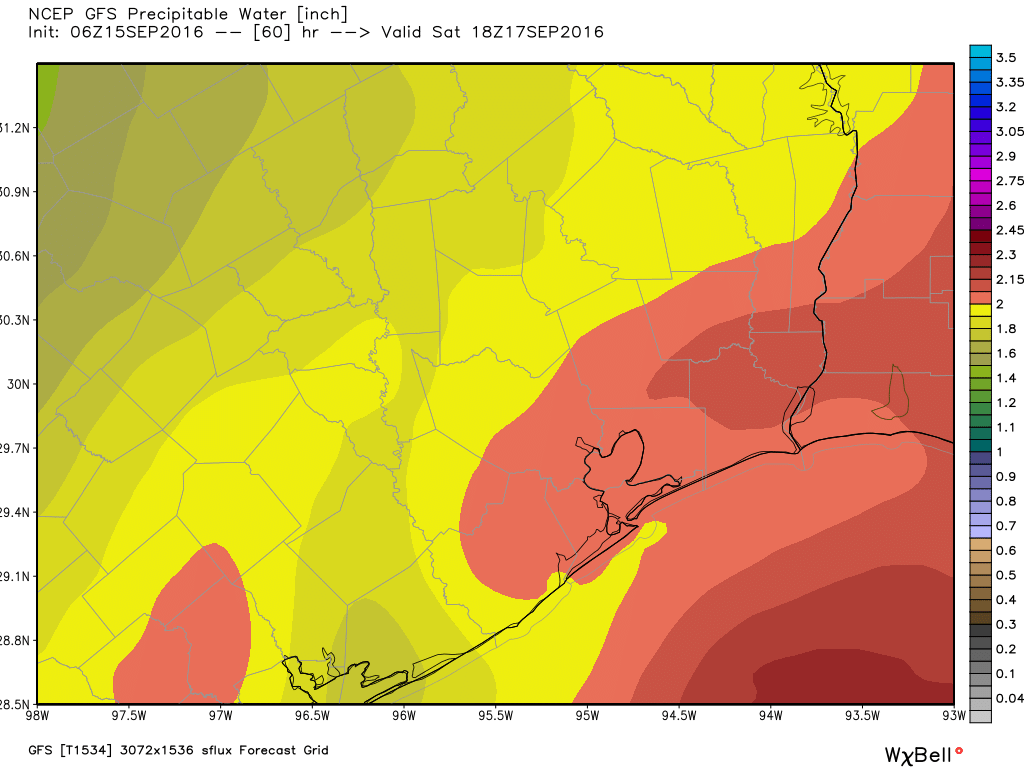
With that said, the tropical system is not expected to bring more than on-and-off rain showers to the entire Houston metro area this weekend. While there could be a few very heavy showers that dump a up to 3 inches in an hour, for the most part we’re probably going to see accumulations generally below 2 inches of rain for the entire weekend, and probably well below that for most inland areas. Temperatures will remain quite warm, with highs around 90 degrees and partly to mostly cloudy days.
Tuesday and beyond
Higher pressure should begin to take control of the region’s weather by next Tuesday or so, bringing down rain chances and putting us back into a partly sunny, late summer-like pattern with highs around 90 degrees and lows in the mid-70s.
We really have to look about 10 days out, at least, to see the possibility of a significant front to break us out of this stagnant, late summer warmth. I wish it were not so.
Posted by Eric at 7:15am CT on Thursday
Eric…so should plan for wet tailgating at NRG this Sunday?
I’d plan for the possibility, but it could just as well be partly cloudy and muggy.
Thanks
But, but, but, Eric, you’ve been saying 10 days out now for about 10 days.
I know. I know. I know. I’m a broken record. Sorry 🙁
Blame it on your assistant, Emo Gee.
He’s about to be fired!
I think back to Ike in 2008…how fortunate were we that a front came through right behind that??? So when I start getting frustrated about how long it will be before we get that nice, first front, I always try and think back to Sep 2008..
Eric – What are your thoughts on the tropical depression off the coast of Africa? Any concerns about it entering the Gulf?
Very low concerns at this time.
The Polish Festival is this weekend and we were planning on going with a group of friends on Saturday. Should we make back up plans (it is an outdoor festival)?
I would have back-up plans for Saturday outdoor events, yes.
The following are my personal thoughts on the upcoming weather situation.
1.Yes, the low pressure area in the Gulf has seen a bump up in its development potential to 20% percent today. This is due to its convective performance this morning, and its developing circulation.
2. It has not been able to advance or really even sustain its convective appearance this afternoon, though for an undeveloped system, it`s not really to be expected at this stage
of development. It’s riding along a pretty sharp gradient in shear, and its future track may provide the limiting factor on its potential.
3. If you’re worried about a TC strike on SE Texas, don’t be. The shear is quite high, and any drift north of west would be likely to keep this area undeveloped. IMHO, it’s got a better chance of slow development as long as it continues on its due west track in because it’s in moderate/marginally favorable shear. Even better chances of development if it drifts south of west because the shear there is even MORE relaxed.
4. Don’t let your guard down, though. With the gradient oriented in this manner, any impacts for our area would likely to be more or less the same regardless of development.
More or less agree with this, thanks for sharing.