In brief: We talk about why, when Arthur’s center was closest to Houston on Wednesday evening, its winds died off. Also, we look ahead to calmer and hotter conditions for the next couple of days, and some rain chances over the weekend.
Looking back at Arthur
Can we agree that it was an odd storm?
Here’s the National Hurricane Center forecast for the position of its center at 4 pm CT on Wednesday, along with a track forecast.
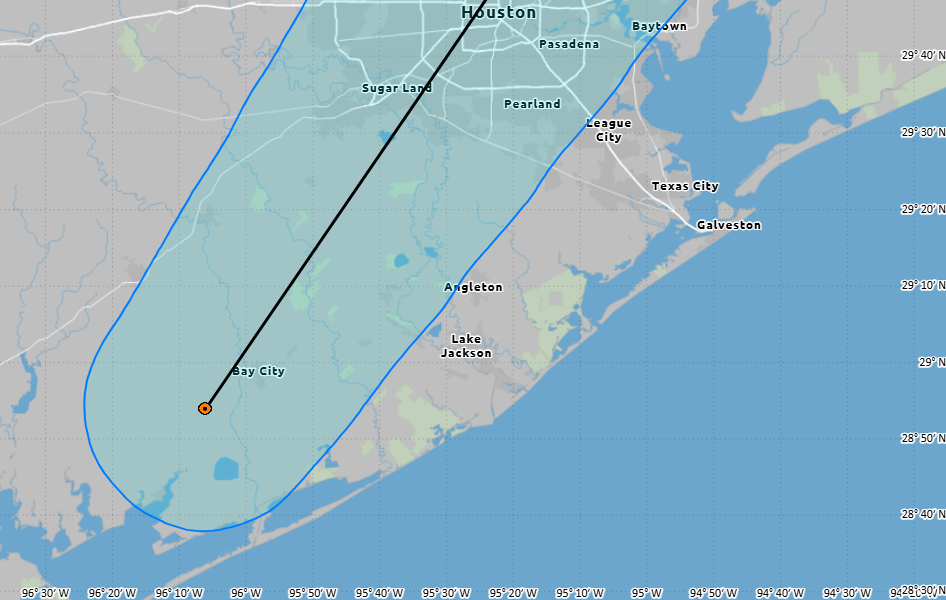
I received a couple of messages yesterday afternoon from readers asking if they should be concerned about this updated track because, as you can see, the center of the storm is forecast to pass directly over Houston on Wednesday evening. And if this were a typical tropical storm or hurricane, the answer would be yes. But I replied no, nothing really had changed with our forecast because the winds and rains associated with Arthur were located hundreds of miles to the east
In the graphic below you can see that the winds in Bay City, where the “center” of Arthur was located at the time, were almost dead calm. And while there were some fairly strong wind gusts at the time associated with Arthur, they were a couple of hundred miles distant from the center of circulation.
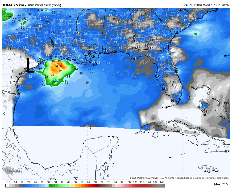
This can happen with weak tropical systems that have fairly poor defined centers of circulation. But it made for an odd situation on Wednesday during which Arthur’s strongest winds came several hours before the center of the storm itself arrived. A similar phenomenon happened with its rains, which were even further removed from the center.
Anyway, Arthur has dissipated and we can all hope this is the only named storm that makes “landfall” in Texas this year.
Thursday
We’re going to see a much calmer day. Mostly cloudy skies this morning should give way to mostly sunny skies this afternoon, with high temperatures reaching the low- to mid-90s for most of the Houston metro area. With dewpoints near 80 degrees, the humidity will be something fierce. Winds will be from the south at about 10 mph today, gusting up to 20 mph this afternoon. Low temperatures tonight probably will not fall below 80 for most of the region, so prepare to sweat. Rain chances are basically zero.
Friday
This should be a similar day to Thursday in terms of temperatures and humidity. There may be a few more clouds in the sky. By Friday evening a weak front (it won’t make it to Houston) will be dropping down from north Texas. This could serve as a focus for some isolated showers and thunderstorms from Friday evening into Saturday.
Saturday and Sunday
I expect skies to be partly to mostly sunny this weekend, with high temperatures generally in the lower 90s. Where we have some uncertainty is in the rain department. The aforementioned dying front could generate some additional showers and thunderstorms on Saturday in the Houston region, perhaps most likely north of I-10. I would put overall rain chances at about 40 percent during the morning and daytime hours, but I don’t have supreme confidence in the forecast at this point. There is a higher likelihood of Sunday remaining rain free.
Next week
By the end of the weekend we should see high pressure taking control of our weather, and this will hold sway for much of next week. We are looking at a sustained stretch of sunny skies and high temperatures in the mid-90s. It won’t be peak summer by any means, but it will likely be the warmest period of weather so far this year for Houston. These temperatures will also coincide with some of the longest days of the year, so be sure and use Sun protection.
