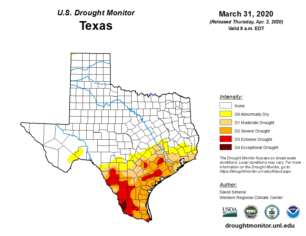
Good morning. All in all, it ended up being a pretty darn nice weekend in Houston. On Friday and Saturday, much of the region got 1 to 2 inches of rainfall. We haven’t talked about it too much here, but the rainfall was really needed with much of the region under a moderate-to-severe drought (see below), and more warm weather on the way. Then, Sunday, was a pleasant spring-like day with a cool start and more sunshine that we originally expected. So, all-in-all, a good couple of days.
Monday
The weak front that pushed into Houston this weekend is pulling back to the north, and this will help introduce a slight chance of showers into the forecast today. But mostly, skies will simply be cloudy, with rising humidity levels, and temperatures near 80 degrees. Winds will turn from the north to southeast throughout the day, remaining fairly light. Don’t expect much of a cool down Monday night, as insulating clouds and the warmer flow will keep lows at about 70 degrees.
Tuesday
This day will be a lot like Monday, albeit a few degrees warmer, with highs edging into the mid-80s. Again, we’ll see the possibility for some scattered showers and thunderstorms in the absence of high pressure. Expect another warmer night.

Wednesday
The warming trend comes to a head on Wednesday, when we may see some partly sunny skies during the afternoon hours. If this happens, the overall flow and the sunshine will come together to push high temperatures into the upper 80s, if not 90 degrees.
Thursday and Friday
The end of the week forecast is somewhat uncertain, as a cold front approaches the area. Right now most of the model guidance suggests the front will punch all the way through Houston into Brazoria County later on Thursday through Friday. However, I’m not entirely confident about this and for that reason then end of the week has something of a question mark hanging over it. In any case, expect most of the region to see highs in the 80s on Thursday, and in the 70s on Friday.
The other element with the front is rainfall, and it seems likely that parts of the region will pick up a healthy 1 to 2 inches of rain. But it’s hard to say whether that occurs over the northern tier of counties, central Houston, or the coastal region. Again, this will have depend on the evolution of the aforementioned front. Bottom line: Thursday and Thursday night will have the potential to deliver some moderate to strong showers.
Easter Weekend
So what does this all mean for the weekend? I’m not at all confident at this point, but after healthy rain chances Thursday and possibly Friday, I think we can generally expect somewhat lower chances by later Saturday, possibly with partly (Saturday) to even mostly (Sunday) sunny skies, which would be eggcellent. Given the uncertainty, don’t hop all over us if it’s wrong. But right now I’d peg highs at around 80 degrees for the weekend, including on Easter Day. Hopefully that’s a paasable forecast.
Any plans to make a post about your ArsTechnica article?
https://arstechnica.com/science/2020/04/forecasters-predict-a-busy-atlantic-hurricane-season/
Thanks for all your support these past few years, this is the only reliable place I trust for my weather news.
Would you have any perspective to lend on the early warnings re: a bad hurrican season? Facts about when it starts? when it stops in Houston? Thank you.
Paasable 😂
Ouch….
We’ve received nearly 6 inches of rain from the past two systems. Power to the precip. I’ll take more which would be most eggcelent. Pretty clever guys.
Well sadly there won’t be an Easter parade, or much else on Easter, although it might be nice to get outside and enjoy some nice weather.
You said “hop”
Re “eggcellent,” before the weekend, some areas had had a “hare too little rain”?
Nice. We as many were in the severe drought and just about ready to go into extreme. Anything helps and God Willing your area will get hit at weeks end to avoid a carrotastrophe. Pretty lame try…sorry.
OK, a stand-up comedian I’m not.