Good morning. The Houston region saw its first real taste of rainfall in two weeks early on Monday as a line of storms pushed from north to south through the area. It was hit or miss in the metro area, with some parts of the region picking up as much as 1.5 inches, and others seeing lightning, but no real rainfall. The storms heralded the arrival of a front that will eventually bring some drier air into the region—which we’ll feel this in the morning and evening.
Monday
Some rain chances will linger into this morning, but as drier air moves in we should see gradually diminished precipitation throughout the day. By this afternoon skies should be partly to mostly sunny, and we can expect highs to reach the upper 90s. Winds will be light, but out of the north at 5 to 10 mph. Low temperatures will be a degree or two cooler tonight, but the real effect will be in the “feels like” department, not the actual mercury. This effect will be more pronounced north of I-10 than along the coast.
Tuesday
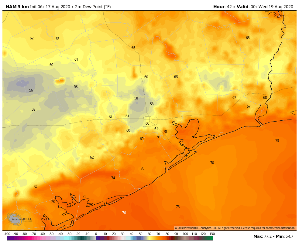
As more dry air filters into the region we’ll see a hot and sunny day. Temperatures will push into the upper 90s, and probably touch 100 degrees for inland areas. If you’re thinking, this sure doesn’t feel like a front, well, you’re right. But this is how cool fronts in August go. There won’t be much impact to temperatures, but evenings and mornings should feel somewhat drier. Instead of dew points of around 70 degrees, which is very sticky and muggy, dew points around sunrise and around sunset may be be about 10 degrees lower away from the immediate coast. A dew point of 60 degrees is definitely not fall-like, but it’s also definitely not “dog’s breath” weather like we normally get in the summer, either. Small victories, people.

Wednesday
This should be another hot and mostly sunny day, but we’ll still feel the influence of dry air in the mornings and evenings. Look for highs in the upper 90s to 100 degrees. We can’t rule out the possibility of a slight chance of afternoon storms.
Thursday and Friday
The onshore flow should begin to return later on Wednesday or Thursday morning, so humidity levels will be on the way back up. In the absence of dominant high pressure, we may see some atmospheric disturbances rotate through the area, and this may raise rain chances to around 40 percent on both of these days. This may help to keep daytime highs in the mid-90s.
Saturday and Sunday
For now, the weekend has the look of a fairly typically summertime affair, with highs in the mid-90s and lows somewhere in the mid- to upper-70s. Rain chances aren’t going away, in that we might see some afternoon showers along the sea breeze. Overall confidence in the weekend is fairly low, so we’ll have to fine-tune these details as we get closer.
Tropics
As noted in Sunday’s post, we’re tracking the movement of two tropical systems in the open Atlantic Ocean. Both are moving toward the Caribbean Sea, tracking mostly westward due to a pronounced ridge of high pressure anchored over the Atlantic Ocean. It seems like the second system, now located off the coast of Africa, may ultimately have a better chance to develop.
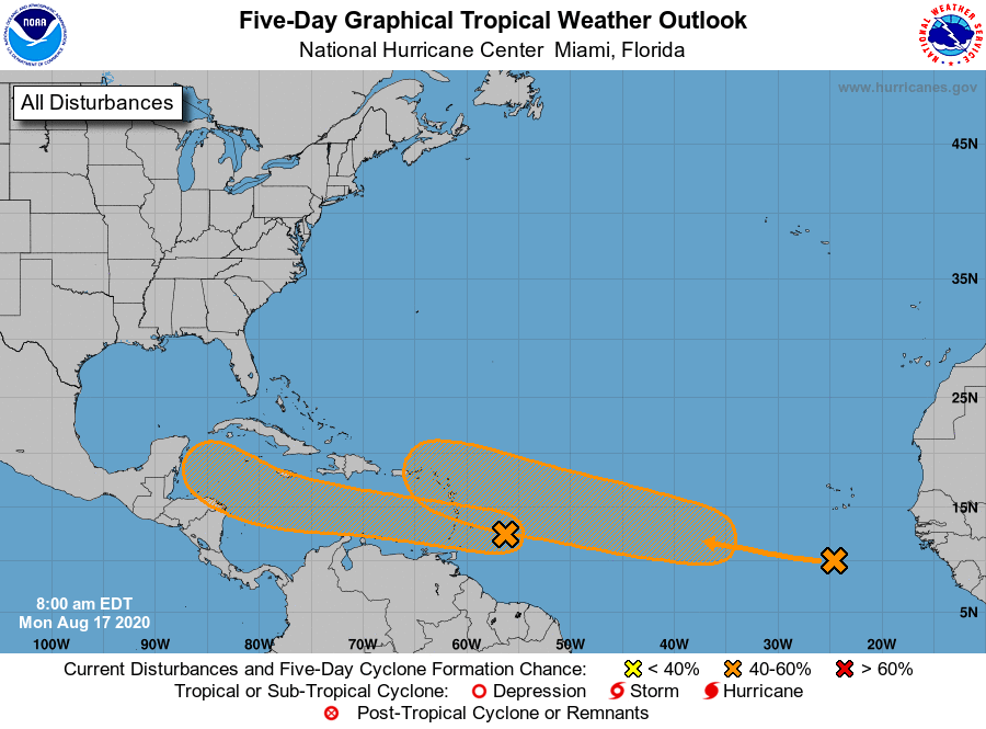
It’s difficult to say much intelligible beyond this, but one or both of these systems may eventually track toward the Gulf of Mexico. Any direct impacts to the coast—from the Bay of Campeche and Southern Texas to Florida—are likely at least a week away. For now we’re in wait-and-see mode.
“Dog’s Breath” is an accurate description if I ever heard one. With lows in the mid to upper 90’s this weekend, the Dogs Breath will be potent!
Is that right!? lows in the mid to upper 90’s this weekend??
No
This said “90’s” this morning when I wrote the comment; apparently this was edited…Eric Berger hung me out to dry… 😉
Went out this AM and for the first time in a LONG time it felt—pleasant. A strange feeling for this time of year. When you’d RATHER be outside instead of in a “conditioned” space.
Personally, I’m affronted by the weakness of this front.
I’ll take drier any time since it makes being outside bearable. The dog days of August fits the “dog’s breath” description.
Continued many thanks to Eric and Matt for providing excellent hype-free reports!
Thanks for the update. Said it before and I’ll keep saying it….this is the ONLY place I look to for tropical weather information.
Thanks for all you guys do!
This tropical information is so helpful, thank you!
I was just outside (it’s 3:15 pm here in WestHOU) and it DEFINITELY feels drier and more tolerable out there.
Eric & Matt. The Netflix docu-series called Connected and hosted by Latif Nasser is both intriguing and entertaining. The first episode is on “surveillance” and features the Veery bird and how their migratory patterns are appearing to predict severe hurricane seasons. One of the latter episodes is on “clouds”. Just wondered if you had seen the series or have heard about the Veery bird and the research being done. The “clouds” segment was lots of fun. Thanks for everything you do.
6 pm model run has back to back cat 1 hurricanes hitting close to here in a span of 6 days.. Lot can change for sure but don’t think I have ever seen that in my 40 years of following storms. Anyone remember anything crazy like that ever happening?