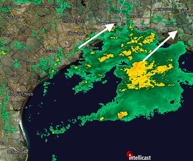
And so it begins … as of the early afternoon hours we’re beginning to see scattered light to moderate rain showers moving into the southern and southeastern parts of the Houston metro area, primarily along the coast. This marks the beginning of about 72 hours in which we’re going to see the region’s wettest period since early this summer.
Matt covered the broad dynamics of the coming rains in a comprehensive post this morning, and at this point not much has changed. I’ve looked over the 12z model guidance and the range of solutions is still pretty broad—from widespread accumulations of 1-2 inches across much of Houston to upwards of 9 inches for wide swaths of the region.
TIMING
It still looks as though most of the rainfall that develops today will be light to moderate, with the heavier rain waiting until later tonight or Saturday to really move in. From then on there will be the chance for on-and-off heavy rain showers and thunderstorms for the period of Saturday morning through Sunday night or even into Monday. This won’t be continuous rain—there will be some breaks—but it will be a wet, cool and gray weekend.
Because some of the more aggressive forecast models are showing the potential for isolated areas to see 8 or 10 inches of rainfall, the biggest concern is flash flooding, and so that’s what we’ll be tracking for you. Unless bedlam erupts this evening, which we don’t expect, look for a new update on Saturday morning.
COLD
Some of you have asked about that looming Arctic cold front we talked about earlier this week. Yes, it’s still on track for Houston sometime next week, during the Wednesday or Thursday time frame. At this point I’d lay about 50-50 odds of a widespread freeze for the northern half of the Houston metro area on Friday morning. I’m not ruling out upper 20s, either.
Alas, the chance of snow is zero. Sorry. But the season’s first real cold blast remains in the cards.
Posted at 2:50pm CT Saturday by Eric
Love your updates. Will be following all weekend
Hey Eric, I just took a look at the picture on the header of your site. Was that taken when the Space Shuttle was flown over LA? I was lucky enough to see that in person, from the top of a high rise in West LA. It was so cool!
Thanks for the awesome updates!!
This is the shuttle flying over Houston, just before it was flown to LA.
Will any of this make it to my hometown of Birmingham or that region where they are in a severe drought? I know the front brought a line of showers for a short time but that was not enough to do hardly anything for the drought.
Yes, I’d look for most of the SE United States to pick up 2-3 inches of rain over the next several days.
Eric, in an earlier post, you didn’t think this weekend would be as bad as what happened on April 18. But from the QPF values, I’d say it’s going to be—-WORSE! You agree or disagree?
When you say “flash flooding” do you mean primarily street flooding, or does that also include Tax Day /Memorial Day events ?
Yes, I’d lean toward mostly street flooding.
Just completed some home remodeling…have some extra wood…glad to hear that I don’t need to build an Ark…