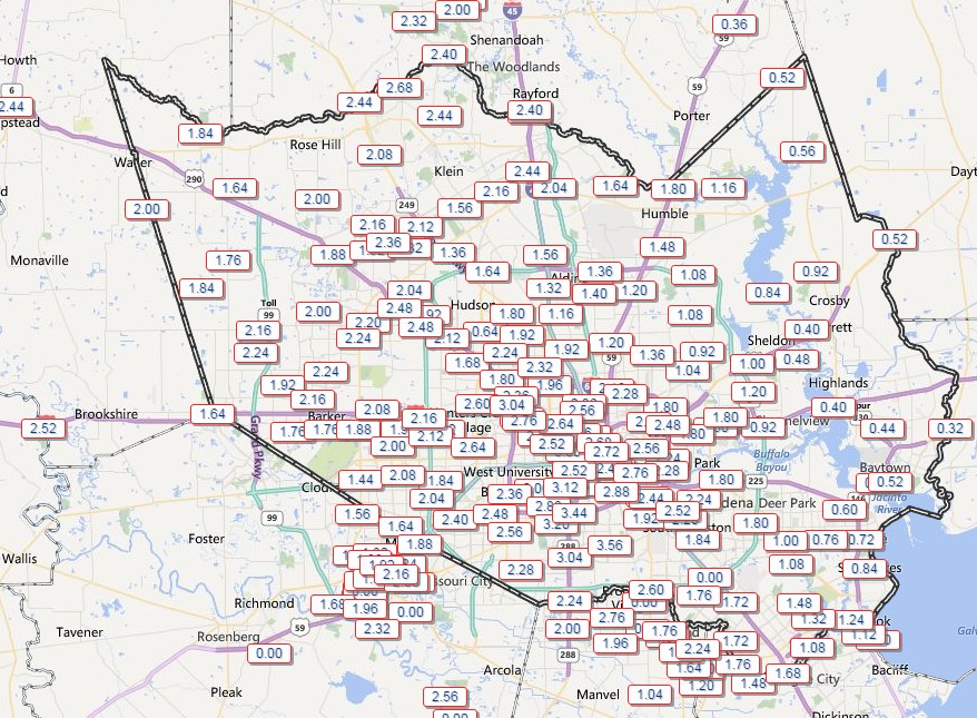
High water — especially near downtown — has caused some 30 road closures around Houston tonight. That’s what 8 to 9 inches of rain in about half a day will do for you. Those who remained at home on Saturday night were wise to do so.
Houston rain totals for the 24 hours preceding 2:30 a.m. Sunday. (HCOEM)
Yet as jarring as the rains have been for some drivers, most Houston residents avoided serious damage from flooding as dry soils soaked up moisture and bayous carried the rest away.
As I write this intermittent heavy showers are still moving across Houston, but the overall trend is one of slow eastward movement of this system.
Therefore, while it seems likely the rain will continue into the middle of Sunday, for most areas there won’t be enough to cause significant property damage.
Houston missed out on some of the very intense rainfall rates that often accompany tropical systems, and whether we can thank the mountains of Mexico for that or the intrusion of some drier air from the west, I doubt few will complain. As for me, I am off to bed, and ready for that pillow.
Steady, moderate to heavy rain showers are continuing to fall across the Houston metro area tonight. But even the most intense showers are only producing rain at a rate of about 1.25 inches an hour. That is within the capacity of most Houston roadways and bayous to handle.
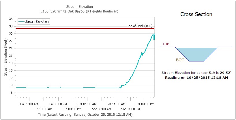
Emphasis on “most.” During the last hour some of the heaviest rain has fallen in central Houston, where areas like White Oak Bayou at Heights Boulevard has risen to within about 2.5 feet of the top of its banks. The bayou is likely to stray beyond its banks later this morning. A number of downtown streets may flood early Sunday morning.
White Oak Bayou at Heights Boulevard. (HCOEM)
It’s also true that there are already more than two dozen roadway closures in the region due to high water. But these are, for the most part, temporary closures of roads that often flood during heavy rains.
The reality is that this storm appeared capable of producing rainfall rates of 3 or even 4 inches per hour, which we have not seen so far today, nor do we seem likely to see on Sunday. This has allowed the region’s bayous to so far largely contain the heavy rain.
Moderate to heavy rains are falling tonight as moisture streams into Houston. As Patricia’s remnants have moved across Mexico and into the western Gulf of Mexico this evening we have also seen increasing wind gusts, already over 30 mph in Galveston.
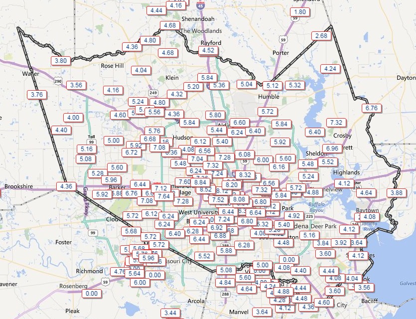
The big question, of course, is how much more rain the region will get tonight. Already, since about noon today, most of the Houston metro area has received 3 to 5 inches of rain. We’ve managed that OK, for the most part, because our very dry soils soaked that rain up, and rainfall rates weren’t exceptionally high — generally below 1 inch per hour.
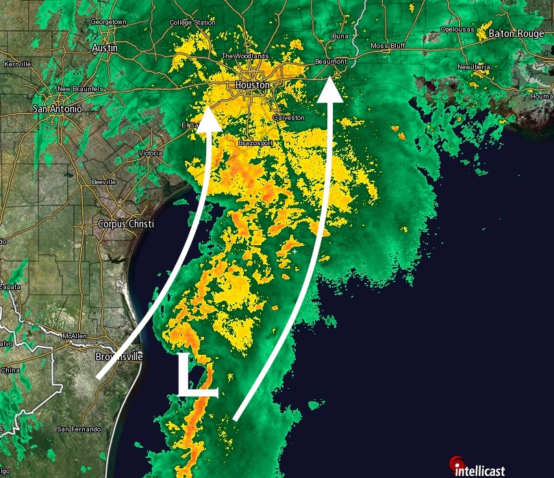
But now the soils are soaked, bayous are beginning to rise, and the rain’s still coming. (Much of the metro area is presently under a flash flood watch.) I posted a similar image to the one below on social media earlier, and it highlights why meteorologists remain quite concerned about overnight rains.
(Intellicast)
There’s a lot going on here. The low pressure system off Brownsville is the remnants of Patricia, now back over the Gulf. It’s not expected to develop as it follows a trough of low pressure and moves up the coast. But to be a potent rainmaker it needn’t develop. As the system moves north-northeast it should help feed moisture (rain) into the upper Texas coast, including the Houston region.
At the same time the radar to the southwest of Houston — i.e. Corpus Christi — is dry. This is because dry air associated with a front is trying to move east, as well. This dry air will help to end rain showers tomorrow in Houston. But it could play some role tonight in weakening activity.
In the end my best guess is that we’ll see an additional 3 to 7 inches of rain over much of Harris and Fort Bend County, and coastal counties including Brazoria, Galveston and Chambers during the next 12 hours or so. If this rain comes all in a bunch, during a few hour period, it will overwhelm some bayous and exacerbate current high water problems on roadways.
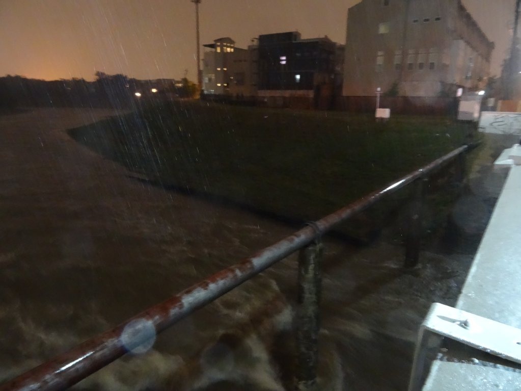
White Oak Bayou in the Heights at about 10 p.m. (Jeff Lindner/HCFCD)
It is going to be a close call tonight, and I will be up to track it. My next post will come around midnight or shortly after.
The first significant rains have moved into Houston this afternoon and early evening as 1 to 3 inches have generally fallen across the area during the last six hours.
Rain accumulations from 12:30 p.m. to 6:30 p.m. Saturday. (HCOEM)
Houston’s bayous have thus far handled the inflow of rain, no doubt aided by the fact that the region’s parched soils have sucked up some of the water and rainfall rates generally have been less than 1 inch an hour.
If the rains hold steady like this there will be few problems. But will they hold steady or increase in intensity? The answer is that, for some areas, tonight will bring mostly steady rains. But for other areas things will get much more intense.