Heavier storms rotating into Houston, major flood event remains likely tonight


As expected, Houston today has so far only seen scattered light to moderate rain showers. However during the next few hours heavier storms are going to begin rotating into the region.

Radar snapshot at 3:45 p.m. shows somewhat stronger storms approaching Houston. (Intellicast)


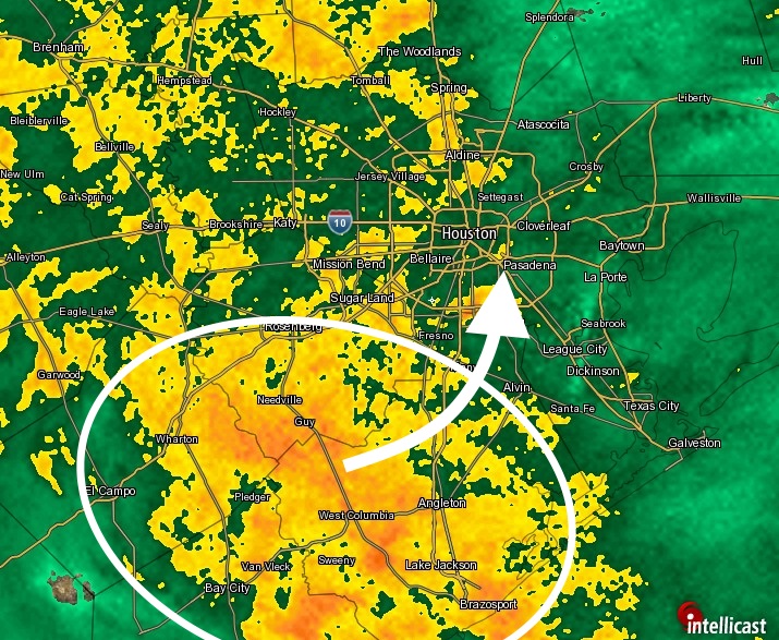
This won’t be the main event, but it’s going to soften up our soils for what should be considerably stronger storms later tonight.

Some of the latest forecast modeling continues to suggest the onset of this heavier rain, with rainfall rates of perhaps 3 inches an hour or higher, around 8 or 9 p.m. this evening. Such storms will have the potential to flood streets quickly.

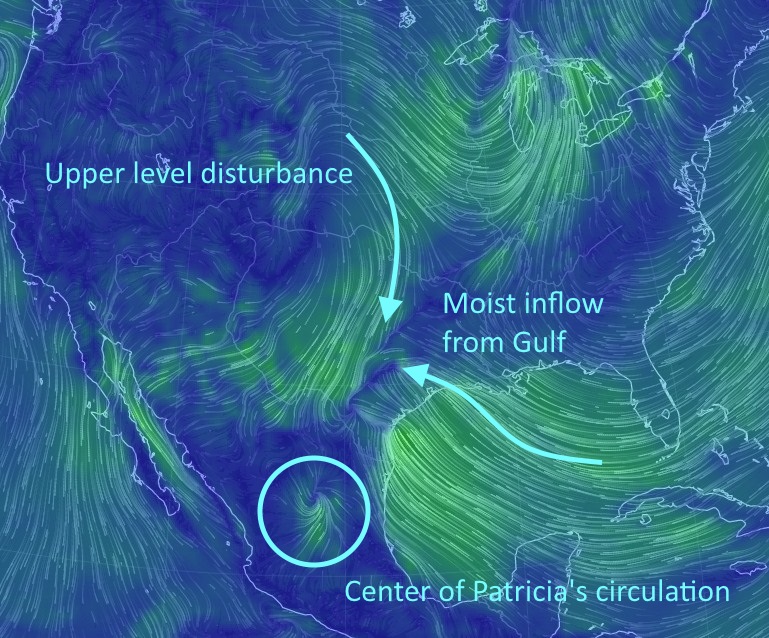
Much of the latest modeling also indicates the very heaviest rains — locations where 10 or more inches might fall tonight — will come along the coast, from Matagorda to Galveston to Chambers and Jefferson counties. That doesn’t rule out inland counties, including Harris County, from such extremes, but that seems to be the way models are trending.

During the last few hours we have also seen favorable conditions for funnel cloud development, and most of the southern half of the Houston metro area is under a tornado watch until 10 p.m. tonight.

I’ll have a comprehensive update on the storms at 7 p.m. tonight.

Posted at 4:05 p.m. CT

Rains moving into Houston, flooding likely later tonight

Patricia has weakened into a tropical depression over central Mexico this afternoon, and it’s continuing to move north-northeast toward Texas. Although its circulation has diminished dramatically, its remnants will combine with an upper-level disturbance moving into Texas from the northwest, and also draw moisture from the Gulf of Mexico.

It looks something like this on the surface wind map:

Surface winds at noon. (earth.nullschool.net)


This will lead to a substantial rain event for Texas, including the upper Texas coast. The principal threat remains heavy rain, and more specifically very intense hourly rain rates that exceed the capability of roads and bayous to carry the water away.

See full post

Potentially dangerous flood event likely later Saturday and Sunday morning

The mountainous terrain of Mexico has shredded the once incredibly powerful Hurricane Patricia, and the system is now a tropical storm as it races northeast toward its soggy destiny with Texas. Patricia will combine with a slow moving cool front and ample Gulf moisture to create a potentially dangerous situation tonight in the greater Houston area.

RAIN ACCUMULATION

Forecast models continue to predict an extreme rainfall event for the Lone Star State, and it appears increasingly likely the heaviest precipitation today and Sunday will come along the upper Texas coast. To start with, here’s the latest precipitation forecast from NOAA’s Weather Prediction Center, essentially the best estimates from their meteorologists assessing all of the models for rain between this morning and the end of the event on Sunday night:

(Weather Bell)
(Weather Bell)

The first thing you’ll probably notice is a staggering 11-inch bullseye over Galveston County and Galveston Bay. This indicates the kind of very, very heavy rain this system and its associated tropical air mass are capable of.

See full post

Welcome to my new weather site

After 17 great years at the Houston Chronicle I’m moving to a new position at Ars Technica covering space. However the editors at Ars realize I have an interest in weather and a dedicated audience, so they agreed to allow me to continue writing about weather for the greater Houston area. I plan to deliver my brand of informative, hype-free forecasting at this site, so if that’s what you liked at the Chronicle, that’s what you’ll get here.

It’s wonderful, really, to be able to combine my two great professional interests. And it’s great to get to continue to interact with the tens of thousands of readers who really seem to value my content.

8004400185_edc67be994_k
Space shuttle Endeavour flies over Houston in 2012. (NASA).

I should also note that Ars is my full-time job, and this site is more of a hobby. For me, however, it’s a very important hobby. I’ll still provide a daily update on weekday mornings, regardless of whether there’s no inclement weather in sight, or all heck is breaking loose. When more significant weather threatens I will work along with Matt Lanza to ensure greater Houston area readers have the information they need to know. This weekend, for example, I will provide wall-to-wall coverage of the impending storms.

Finally, you can follow me on Facebook, or a new Twitter account, to receive notification of updates here, and further Houston weather tidbits.