Tropics: Invest 97L still spinning, but probably not bound for Texas

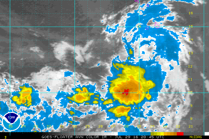
After Matt’s thorough tropical update on Saturday, and notably the area of interest known as Invest 97L, I thought I’d provide a shorter update today.

The system has now crossed over the Leeward Islands into the Caribbean Sea, and it continues to move westward, likely bringing winds and rains to Puerto Rico today. The National Hurricane Center continues to predict a 70 percent chance that this system develops into a tropical depression or storm within five days.

And after that? In the post Matt pointed toward two scenarios for what happens to 97L if it makes it into the Gulf of Mexico by around next Friday, or so. The first is that a fairly strong ridge over the southern United States keeps the tropical system to the south of Texas, confined to the Bay of Campeche. This solution was favored by the European model. The other possibility was that this ridge would shift east in about a week, allowing 97L to follow a more northwesterly track toward Texas. However the GFS model which had shown this weakness, appears to be trending toward a stronger ridge.

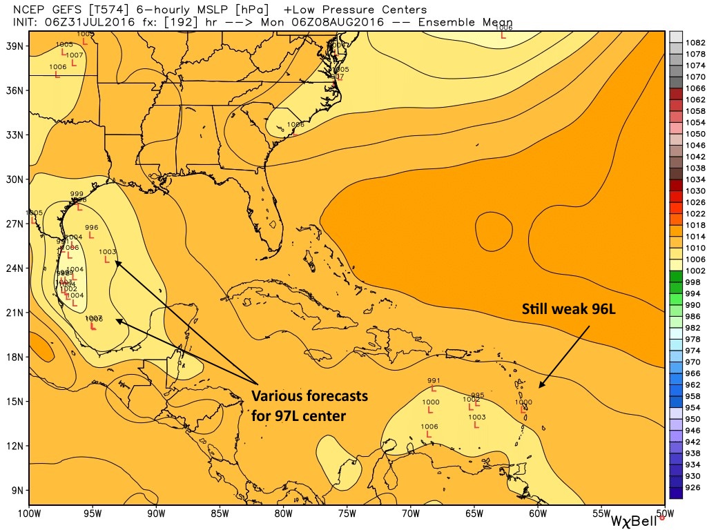
Models begin to align?

The image below shows the ensemble forecast from the GFS model this morning (06z run) which essentially means the model is run a number of different times, with slight different initial conditions. You can see that the majority of solutions now keep the storm well to the south of Texas.

GFS ensemble forecast for tropical low locations early Monday morning. (Weather Bell)

See full post

Weekend Tropical Update

It’s still a bit early in the game, but we wanted to bring you up to speed on a couple tropical disturbances in the Atlantic that are driving “chatter” in social media and elsewhere about how they may or may not impact Texas and elsewhere. Let’s dig in.

“Invest 96L”

Before a tropical disturbance becomes a depression or named storm, for the purposes of running models and collecting data, the National Hurricane Center uses the designation “Invest” (90-99) to describe a system. Basically, it just means an area they’re investigating for possible future development. Invests are common and have a sequential numbering scheme that repeats through the season.

With that in mind, we have two “invests” out there. The first one is 96L, a system about 400-500 miles southwest of the Cape Verde Islands. It’s not terribly well organized, but it has a slight chance to develop over the next couple days.

Invest 96L slogs across the far eastern Atlantic, not terribly well organized. (NOAA/NHC)


Reliable weather models are mostly unenthused with the future prospects of Invest 96L. I haven’t seen any reason to think this will develop into much of anything, and its long term prospects likely do not include the Gulf, so no worries here for us.

See full post

Back to regularly scheduled Houston summer

As we go into the weekend, the heat will begin to turn back up over Texas, as more standard summer returns. One interesting statistical nugget from the other day: Wednesday was the first time since June 12th that we had not hit 90 degrees in Houston, ending a 44 day streak that ranks tied for 15th longest 90+ streak all-time with 1902, 1958, and 1988. The longest recent streak of 90+ that we’ve seen occurred last year, 49 straight days from July 2 through August 19. The longest ever? 81 days in a row in 1890. I can’t even imagine…

Today

After another noisy afternoon yesterday, especially north of I-10, we’ll probably see some scattered storms around the region again today. That said, I don’t think storms will be as widespread as the last few days. Some heavy rain will be possible however again in a few spots, but those will be the exception, not the rule. We poked back into the 90s Thursday, and I suspect we’ll do it again today, probably closer to the mid 90s, typical for mid-summer.

Weather models imply we should at least see a few showers or storms by this afternoon. (Weather Bell)

See full post

Drier, warmer pattern looms after a stormy week

Good morning. It’s been a mostly wet week to bring July to a close, and yesterday we saw some much needed rain just to the north of the city of Houston. As a result most of the area has seen 0.5 to 2.0 inches of rain during the last three days, a nice reprieve from what was otherwise a sweltering month. This rather wet interlude may soon draw to a close, however, as drier weather looms.

Fortunately that does not mean we are going to climb back toward the 100-degree temperatures we experienced last weekend. Houston continues to fall between two high pressure systems—one over the western United States and one along the east coast.

Texas lies between two high pressure systems at the moment. (Weather Bell)

See full post