Good morning. A cold front will move across the area this morning, ushering in a period of significantly cooler weather after an abnormally warm spell that has lasted more than two weeks.
Today
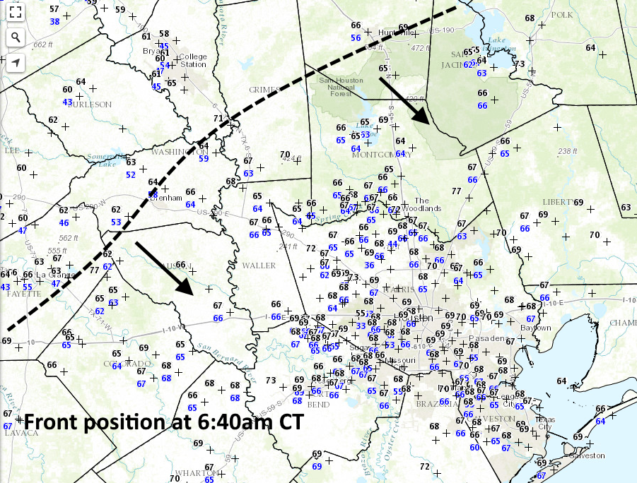
Some very light rain has fallen ahead of the front, and more scattered, light showers are possible as the front moves through northern Houston around sunrise, and off the coast by, or before about noon.
Cold front position as of 6:40am CT on Wednesday morning. (National Weather Service/Space City Weather)
In the wake of this morning’s front winds will be moderate, holding at about 5 to 10 mph out of the north rather than gusting strongly. Highs today should remain in the 60s for areas well inland, but will still reach the lower 70s for coastal areas. Drier air will allow the area to cool off quickly this evening, and lows should fall to around 40 degrees for inland areas, and the mid- to upper-40s closer to the coast.
A fairly cool morning—with temperatures in the 50s—will quickly warm and give the region one more warm day before winter-like conditions settle across the region for the rest of the month.
Today
As winds pick up out of the south today, with gusts possibly pushing into the low 20s mph especially along the coast, we’re likely going to see temperatures rise into the low 80s this afternoon under mostly sunny skies. This will be this winter’s 10th day of high temperatures that reach 80 degrees, or higher, and the last for awhile. Temperatures tonight won’t moderate too much, falling only into the low 60s across most of the area.
Wednesday
Some time on Wednesday morning, perhaps around sunrise, a cold front will move through Houston. It’s likely there won’t be enough moisture in the air to allow for much, if any, rain to develop with the front’s passage although a few scattered showers can’t be entirely ruled out. Temperatures won’t climb much on Wednesday as highs reach about 70 degrees under clearing skies. Northerly winds will dry things out, and lows Wednesday night should fall into the 40s—low for inland areas, upper for those closer to the coast.
Houston will host Super Bowl LI on Sunday, February 5th, at 5:30pm CT. Here’s an early look ahead at the forecast for Super Bowl week in Houston, and for the game itself.
Super Bowl week
We can have fairly high confidence that Sunday, Jan. 30th, Monday and probably Tuesday of Super Bowl week will have fairly chilly weather—for Houston. All available climate signals point toward highs of around 60 to 65 degrees, with lows of about 40 degrees.
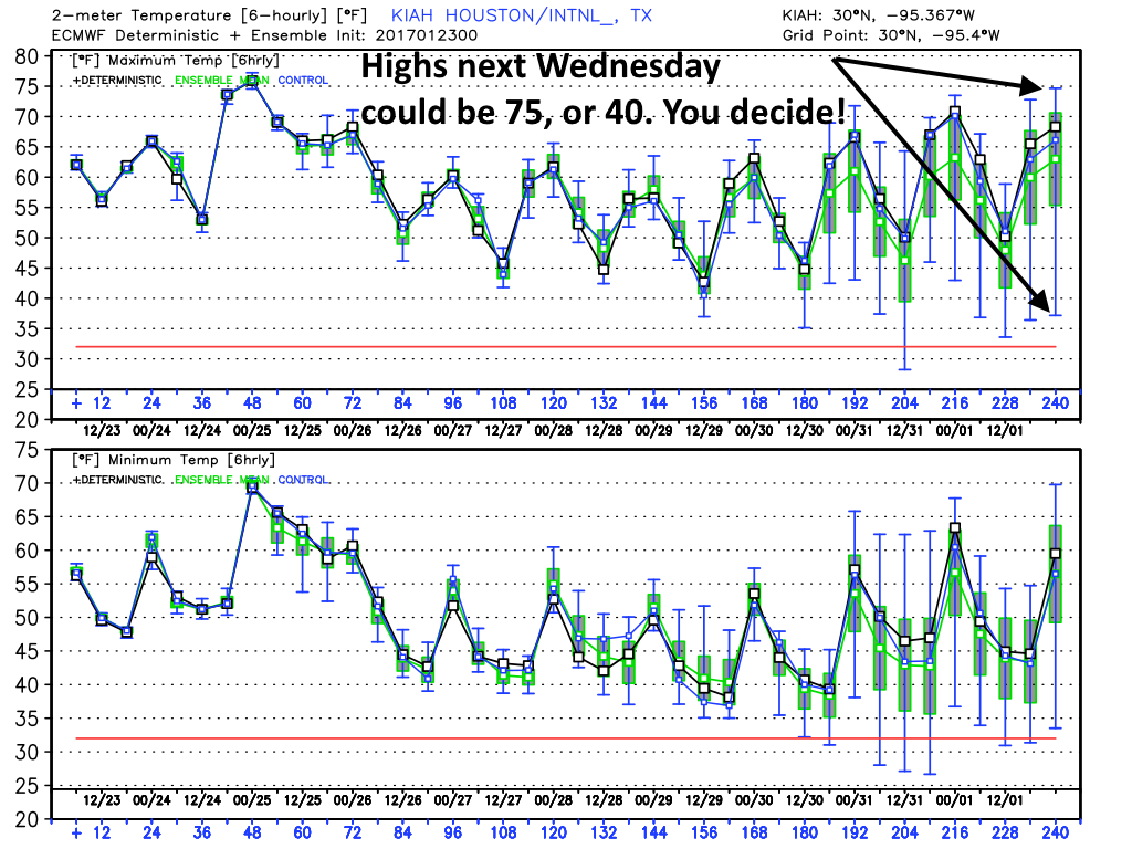
The question then comes as to what happens from Wednesday through about Friday? Some of the guidance suggests fairly rapid warming, with high temperatures rebounding into the upper 70s. However other models bring another front through by Tuesday or Wednesday, to keep the colder weather going through most of Super Bowl week. I don’t see any real clarity in the forecast at this point, I’m afraid.
European model 10-day temperature forecast. (Weather Bell/Space City Weather)
In terms of precipitation, I don’t see any kind of a washout in the cards, but some light precipitation is possible toward the middle or end of next week.
Super Bowl weekend
And what of the big game? Regardless of the midweek front, the GFS ensembles are leaning toward a warmer game weekend, with a high temperature in the upper 60s to mid-70s on Saturday or Sunday.
In regard to the European model, many of the ensembles are suggesting a fairly strong cold front might move through sometime during the first week of February. If that happens before Sunday game time temperatures might be quite chilly, in the 40s or 50s. If it doesn’t, we could be back to highs of around 80 degrees by Saturday, Jan. 4th and Super Bowl Sunday. One forecast we can have confidence in: The roof will be closed, regardless.
The winds finally died down shortly before midnight on Sunday. Peak gusts for inland areas—to the north and west of US 59—were generally 40 to 45 mph, while peak gusts closer to the coast generally ranged from 45 to 50 mph. But now, as our weather settles down into a more winter-like pattern, here’s a look back at the warmth this month, and ahead at cooler weather.
Warmth
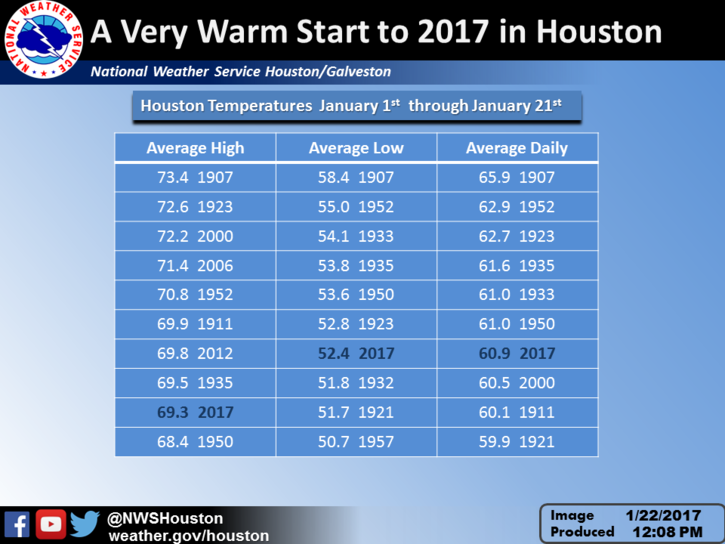
The first eight days of January were quite cold, with an Arctic blast that drove overnight temperatures into the low- to mid-20s for three nights. But since then the region has been anomalously warm. Accordingly, the average temperature for the month through three weeks has been 60.9 degrees, which ranks 7th on the list of all-time warmest Januaries for Houston—so far. I think we may finish just outside the top 10 given a cooler last week of the month.
(National Weather Service)
Another measure of warmth is the number of 80-degree days, a marker for truly abnormal, daily heat during winter. Houston has recorded nine 80-degree days so far in December and January. According to the National Weather Service the record for total number of 80-degree days in “winter,” defined here as December through February, is 17, which has happened three times (1995-96, 1956-57, & 1910-11). It’s certainly not out of the question that we pick up seven or eight 80-degree days in February, so we’ll see. But for the rest of January I see the opportunity to add one more.