Yes, it’s probably too early for a hurricane season outlook

With quiet weather, I wanted to take a second to address some viral weather news. We’ve gotten several messages or comments from folks concerned regarding a hurricane outlook that’s being widely shared on social media, particularly Facebook. If you haven’t seen it, the gist of it is what you’d expect from a hurricane outlook in March that’s widely shared on Facebook: Gloom and doom.

I did some digging on the source for the viral post, and while they have over 70,000 Facebook followers, if you try and find out who they actually are, you hit a dead end. I have no idea if the owner of the site sharing this outlook is a degreed meteorologist who created this forecast or is sharing someone else’s with their followers or some guy in Kansas who just likes spinny things. Typically, if I cannot determine who an information source really is, I instantly treat them with a healthy dose of skepticism. And you should too. If it’s any comfort, Eric and I don’t see anything alarming about the upcoming season at this point. That may change — or it may not. It’s still quite early after all. I can tell you personally, as someone who has created a number of hurricane season outlooks for work, there is very little skill in March at predicting where storms will make landfall during the season. Believe me, I’ve tried. And failed every time.

Meanwhile, the actual experts on seasonal hurricane outlooks reside at Colorado State University. They have a good track record historically, and they back their thinking up with a lot of good data. Their early outlook is slated to be released on April 5th. It may be similar to the outlook you’re seeing shared on Facebook. Or it could be entirely different. I honestly don’t know. I do know that even the Colorado State experts will tell you to treat all seasonal hurricane outlooks cautiously.

More importantly, rather than focusing too much on the specifics of an outlook this far in advance, use this time as an opportunity to reset yourself now that we’re months past Harvey. We live in a very hurricane-prone part of the world. I wish we could tell you we’re good for a few years, but we don’t have that luxury in Texas. This is a good chance for you to rehash your evacuation plans, make plans to develop your emergency kit as we get closer to June, and learn more about the risks that may exist in your neighborhood. The time you spend now preparing will help you a lot if a storm threatens us again this season. And if we have nothing to worry about this year? Awesome! We hope that’s what we’re saying in October.

Anyway. We wanted to clear the air on that. On to the weather.

Today & Wednesday

As expected, a pair of stellar days is ahead. Yes, we may have some passing high clouds at times today and tomorrow, but for the most part, sunshine will dominate. A chilly start to today (even some 30s up north!) will warm into the upper 60s this afternoon.
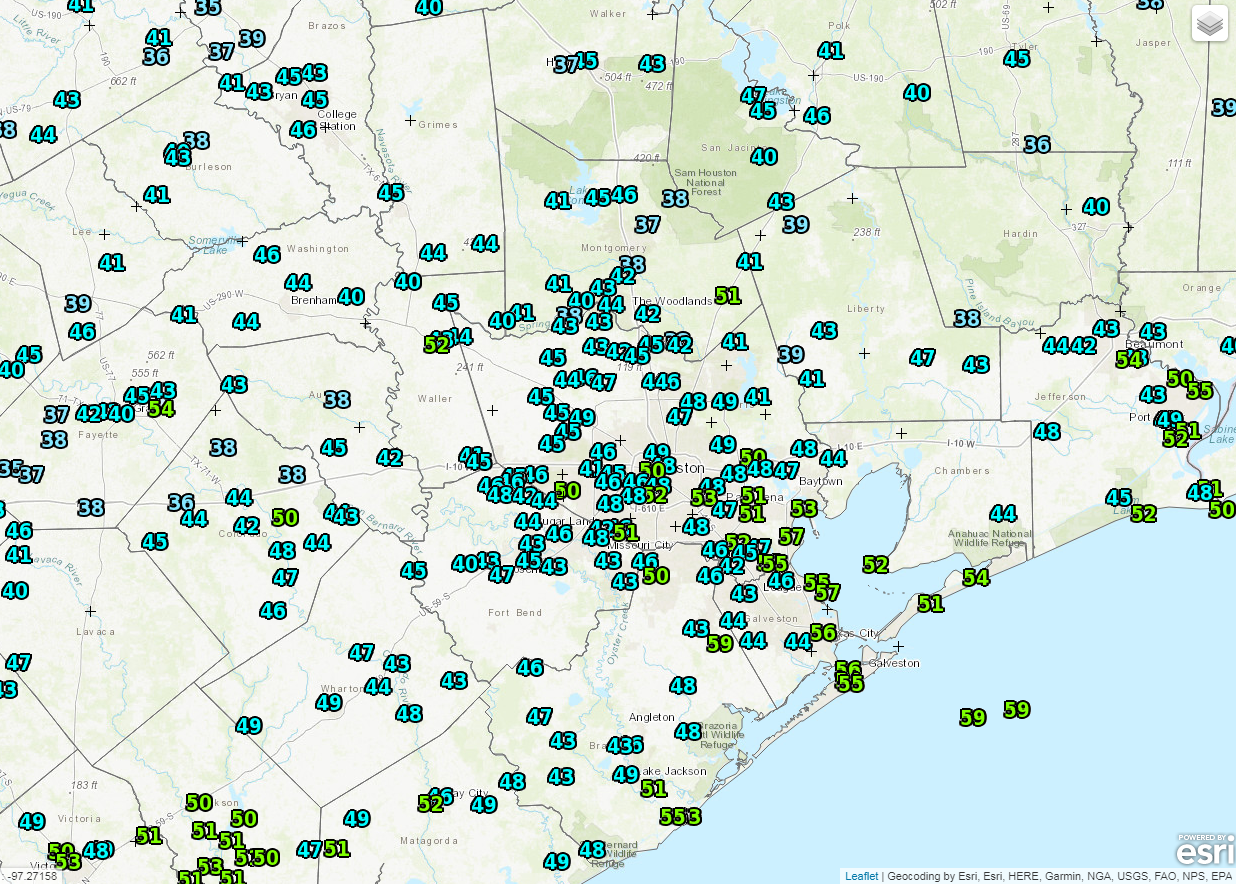
I spy 30s west and north of Houston as of 6 AM! (NOAA/NWS)

We’ll drop back into the 40s again tonight before we approach 70 degrees on Wednesday. Perhaps a bit cool for the beach, but beautiful nonetheless.

See full post

Sublime start to spring break week

Well, a good morning to you all. We are in for a treat to start this week. And the back half of the week doesn’t look terrible either. So in case anyone was worried about the forecast changing over the weekend, we have good news that it really has not changed!

Today through Wednesday

All the sunshine. Seriously, the next three days look magnificent. First, a quick note on the wind, which has been howling periodically overnight. It will begin to settle back during the day today. Expect less frequent wind gusts, though it will stay breezy at times. Besides that, over the next few days, the only real risk for a hiccup will be a few periods of high clouds that sweep through. As of right now, they don’t appear to be too thick, but the best chance for a little cloud cover to interfere in the beautiful weather would be Tuesday morning into early afternoon, and again later Wednesday afternoon.

A few high clouds will skirt by today, but otherwise, it should be near-perfect once the wind eases up. (College of DuPage)

As far as temperatures go, we’ll warm from the 40s or low-50s this morning into the middle 60s this afternoon. Look for tomorrow to start in the 40s and warm into the upper 60s during the afternoon. Wednesday should be close to a repeat of Tuesday, warming from 40s to near 70 in the afternoon. All in all, this is pretty close to perfect.

See full post

Quiet spring break appears ahead for Houston

Good morning! I want to start with a couple housekeeping items today.

Edit: One of our readers has provided a good explanation for the below that confirms the source of Thursday’s smoke was local, not from Oklahoma. See the comments below for his explainer. For the sake of transparency, I’ve left the original post in tact.

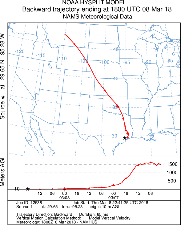
First, the smoke yesterday. We got a couple comments and tweets about it. The unfortunate answer is that we really don’t know for sure where it came from. The going theory is that it probably came from some unknown local source. Certainly possible, but I have a sneaky suspicion it could be because of fires and controlled burns in Oklahoma. If you ran a backwards trajectory on the air mass over Houston yesterday back 48 hours (in other words, where was the air over Houston yesterday 48 hours prior?), our air came from the northern Rockies, traveled across Oklahoma and North Texas, and eventually sank to the surface near Houston.

Yesterday afternoon’s air over Texas may have picked up smoke over Oklahoma as it came south and lowered to the surface in Houston, bringing the smoke with it. (NOAA)

The air mass would have been over Oklahoma and northeast Texas on Wednesday afternoon and evening. I believe there were quite a few controlled burns and a few other fires up in Oklahoma or North Texas then that could have ended up making the trip south with our cooler air. Otherwise, the smoke was indeed from somewhere closer to Houston, but no one really knows for sure. Anyway, I found it interesting and thought I’d share.

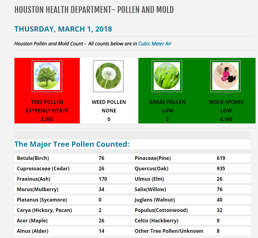
And if the smoke wasn’t enough to put a damper on your day yesterday, the pollen count probably was. How bad was it yesterday?

Tree pollen, particularly oak pollen is the league leader in irritating your nose. (City of Houston)

Tree pollen often flares up this time of year. For me, it’s usually a battle between oak and cedar in terms of what can drive me away from outdoor activity. Oak is dominating the board right now and likely will continue to do so for the next few weeks. Oak pollen usually eases up in late March or April. The city of Houston has a pretty good pollen and mold count site I recommend for bookmarking. You can also examine historical data too.

On to the forecast.

Today & Saturday

We’ll start out with sun and some clouds today. I expect clouds to gradually thicken up as the day goes on. I wouldn’t be shocked to hear about a few sprinkles or showers southwest of Houston this afternoon. It’ll be warmer and gradually turn more humid today. Look for highs in the lower 70s. A disturbance passing by overnight should touch off at least some scattered showers or a rumble of thunder. The best chance of this would be south of I-10. Look for mid-60s overnight, and total rainfall ranging from nothing to a few tenths of an inch overall.

On Saturday, there will continue to be a few showers or even a thunderstorm or two around in the morning. As of right now, we expect the afternoon to be mostly quiet. A shower or two is possible, but the atmosphere over Houston will likely be capped, meaning showers and storms will have a tough time developing. It will probably still be a mostly cloudy day with a few sunny breaks at times. You should be able to go about most plans with scant interruption tomorrow. Highs on Saturday will peak around or above 80 degrees.

See full post

Houston’s next cold front arrives on Sunday

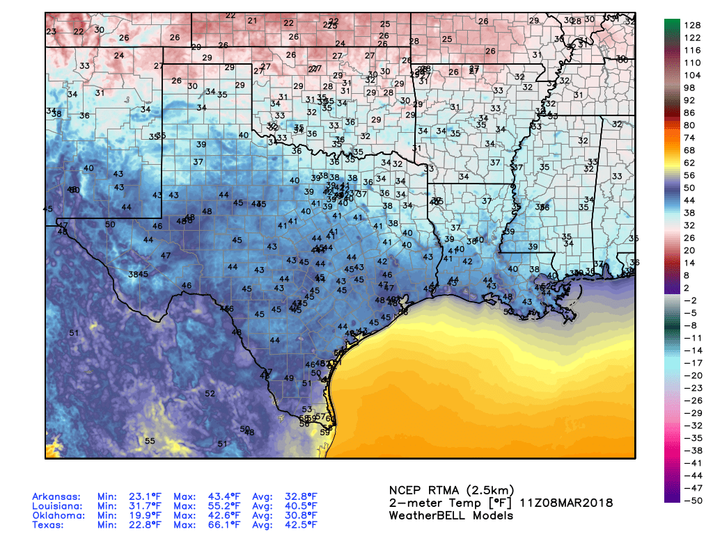
Chilly temperatures have descended across the greater Houston area this morning, with lows generally in the 40s and 50s. This drier air will begin to exit the region as a more moist flow replaces it. This will lead to a general warming trend through Saturday, before the next cold front arrives on Sunday. As discussed on Wednesday, the week of Spring Break still looks pretty fine.

It’s cold in Texas this morning, but not freezing like in some neighboring states. (Weather Bell)

Thursday

The region will see partly sunny skies today, with high temperatures likely in the upper 60s. Some clouds are mixing into our skies, too, and this trend should persist later today as the onshore flow reestablishes itself. Low temperatures tonight will probably be in the 50s for most of Houston, and warmer along the coast.

See full post