Houston’s weather will remain quiet, and mostly spring-like, until the arrival of a cold front this weekend brings a healthy chance of storms to the region. We’ll focus on that possibility in this forecast.
Wednesday
Highs today will be in the low 80s, with ample cloud cover as moisture streams into the region. Some (almost certainly very light) rain showers will be possible this afternoon, and during the overnight hours, as a cold front approaches Houston, and then pushes off the coast early on Thursday morning. Most areas probably won’t see rainfall, and those that do will only see slight accumulations.
Thursday
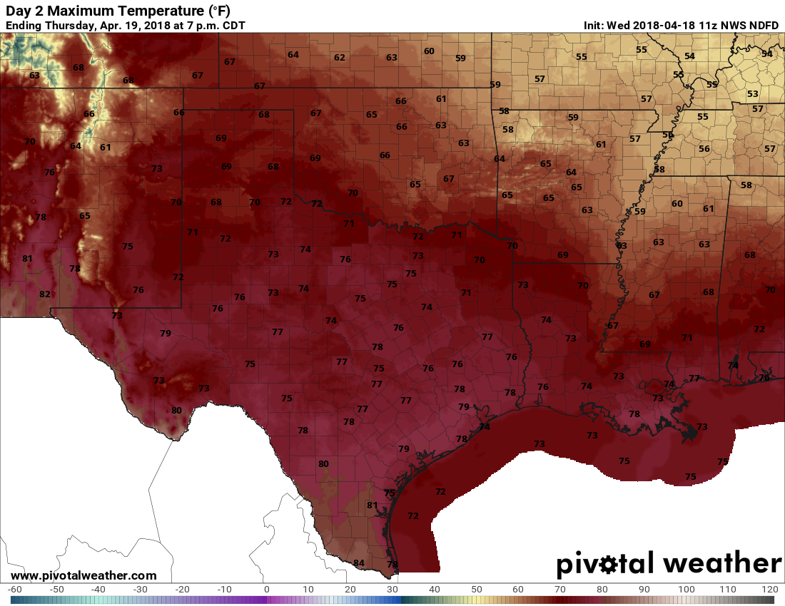
An exceptional day, with modest northerly winds, highs in the upper 70s, drier air, and sunny skies. Skip work, play hooky, plan an outdoor lunch—do whatever you need to do to spend this one soaking up springtime in Houston. Lows Thursday night will be in the 50s for inland areas, and lower 60s along the coast.
Thursday’s high temperatures look splendid. (Pivotal Weather)
Friday
Another very nice day, with highs in the mid-70s, and partly sunny skies.
After what can only really be described as absolute perfection on Monday, Houston’s weather will turn a little windier, a little warmer, a little more humid, and by the end of the week more stormier. Still, all things considered with summer looming, this should be a pretty fine spring week.
Tuesday
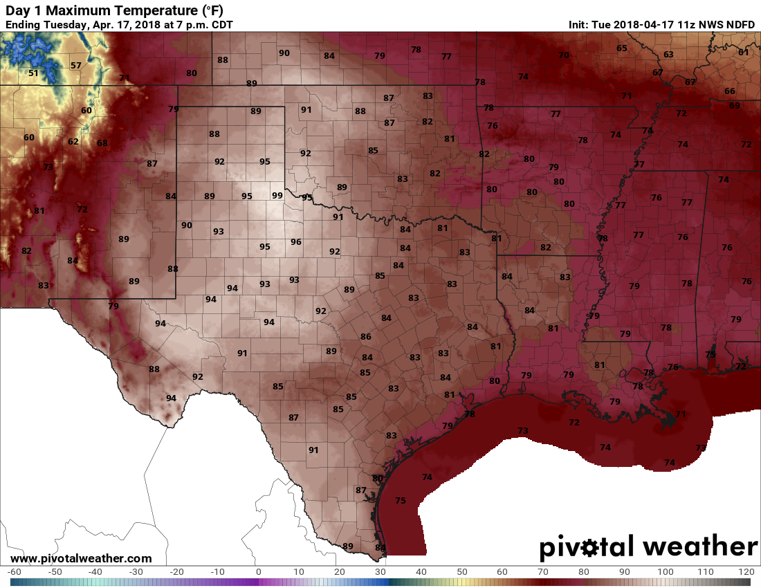
Following a chilly start, with low temperatures in the upper 50s, the mercury will rebound pretty quickly and we’ll see highs in the low 80s. The onshore flow has really reestablished itself, and that will manifest itself with gusty southerly winds later today. Skies will remain sunny. Overnight lows probably will only dip into the mid-60s for most of Houston, as humidity levels remain pretty high.
Check out those highs in West Texas on Tuesday afternoon. (Pivotal Weather)
Wednesday
Due to an approaching (weak) cold front, and rising moisture levels from the onshore flow, lot of clouds will return to the region on Wednesday. We may also see some scattered showers, but any accumulations should be pretty slight—maybe enough to get the street wet but not a whole lot more. Highs will be around 80 degrees. The front should reach Houston later on Wednesday, and ever so slowly sag down toward the coast during the evening or overnight hours. It won’t have much oomph.
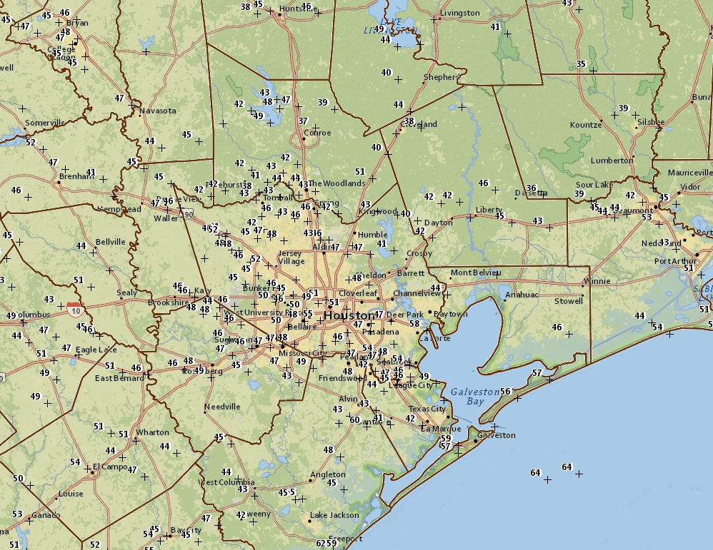
Houston won’t reach record lows this morning (38 degrees, set in 1983), but for mid-April it is quite cold out, with upper 30s north of the city in places like Conroe and Cleveland, and mid- to upper-40s across most of the rest of the region except for coastal areas. I feel confident in writing that this will be our coldest spell of weather—Sunday and Monday mornings—for at least six months. We’ll return to more seasonal conditions for the rest of this week.
Houston area temperatures at 6:30am CT on Monday. (NOAA)
Monday
A fine, fine day with only very light winds, sunny skies, and high temperatures in the upper 70s. Later this afternoon winds will swing to come out of the south, representing the beginning of an onshore flow, but we’ll still see a cool-ish night tonight, with lows in the upper 50s for inland areas, and lower 60s along the coast.
Tuesday and Wednesday
These days will be a bit warmer, and more humid as atmospheric moisture levels rise. The southerly winds could be gusty at times. I’d expect high temperatures in the low 80s, with warmer nights in the mid- to upper 60s. I think we’re still going to see partly to mostly sunny skies. A weak cool front will push into Houston on Wednesday, and probably move just off the coast. While we can’t 100 percent rule out any showers with this front, I think a capping inversion will prevent most people from seeing any rainfall.
Good Friday morning, and here we go again with another cold front and storm chances. Fortunately, while we can’t entirely rule out some severe weather, it seems fairly unlikely for most of us. We’ll see lingering clouds Saturday, but we’re set up for some beautiful weather Sunday.
Today
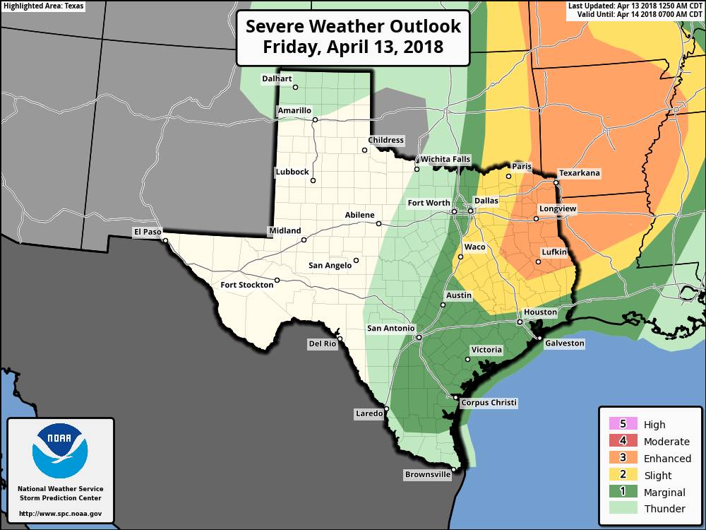
We’re socked in with clouds this morning, indicative of a lot of moisture in place at low levels of the atmosphere. This is all basically “trapped” under a capping inversion (“the cap”) that we often talk about this time of year. What this will likely do is inhibit thunderstorm development over much of the region during the day today, but it will keep things somewhat dreary with clouds and occasional showers or light rain in spots. While we can’t entirely rule out a stray storm north of the Houston area, any significant severe weather threat this afternoon will likely stay way to our north, closer to Texarkana.
While we can’t entirely rule out an isolated severe thunderstorm this afternoon in northern parts of the area, the best chances for severe weather are closer to Texarkana, Shreveport, and up into Arkansas. (NWS SPC)
It will remain fairly breezy, with gusty onshore winds sustained around 10-20 mph, with higher gusts, especially near the coast.
Tonight & Saturday
As we go into this evening, the cold front will begin to approach the area from the north and west. Right now, I would expect a fairly well organized band of showers and storms with it as it moves through the region around or after midnight. So expect to hear raindrops at some point tonight into Saturday early morning. Will we see severe weather? It’s possible, but I don’t think all the ingredients are quite there for it to occur. If we were to see storms go severe overnight, I think the primary threat would be strong winds. Still, even without severe weather lightning, thunder, gusty winds, and briefly heavy rain are all possible. Total rainfall will be under an inch for most of the region, with some areas likely seeing well under a half-inch.
The front pushes offshore Saturday morning. Expect continued clouds and perhaps even a few lingering showers through about midday Saturday. We should then see slow clearing. Winds will stay gusty but flip from onshore to offshore. Expect those to gradually diminish Saturday afternoon.
The tricky aspect to Saturday’s forecast will be temperatures. They will drop off behind the front, with Saturday morning lows bottoming out in the low 60s at the coast and mid to upper 50s inland (even a bit cooler in the Brazos Valley or up toward Huntsville). But it gets challenging on Saturday afternoon. If cloud cover and showers persist beyond midday and into mid-afternoon, we’ll likely see temperatures hold in the upper 50s to low 60s most of the day. However, if we see clearing and get a good bit of sunshine Saturday afternoon, look for temps to rebound to the upper 60s.