Alas, we’re facing another wet weekend in Houston

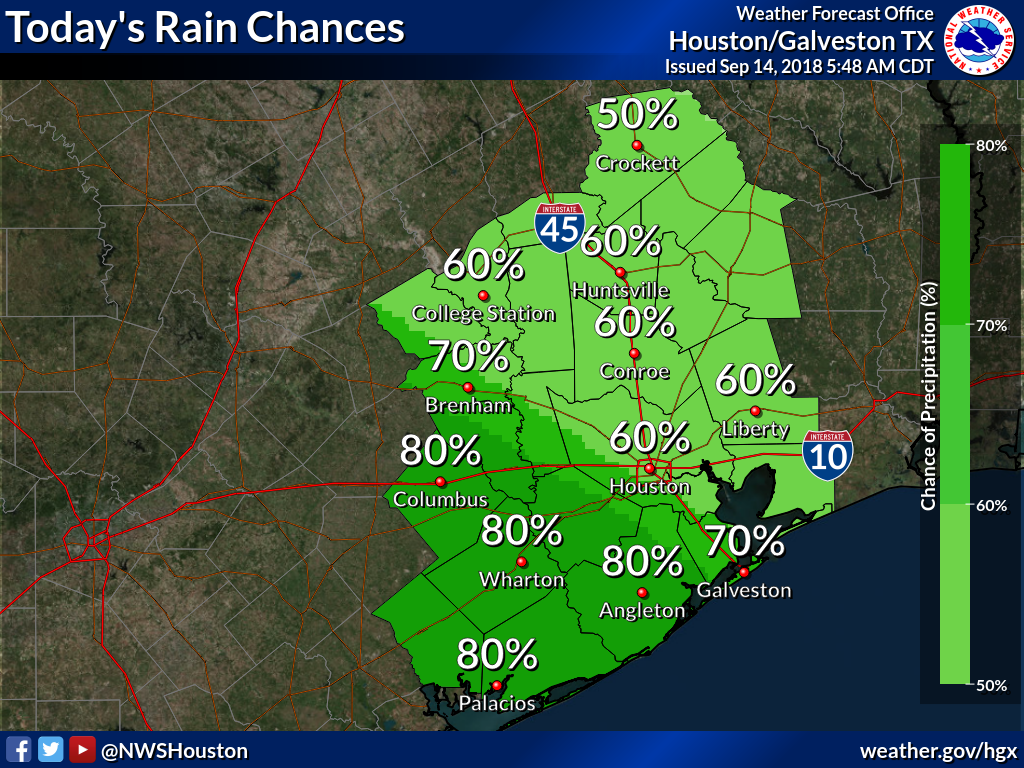
We think next weekend at the end of the month probably looks fairly nice, if that front we mentioned in Tuesday’s post comes to pass. Unfortunately, this immediate weekend doesn’t look great. And by not great, we mean a healthy chance of rain showers with the possibility of locally heavy rainfall.

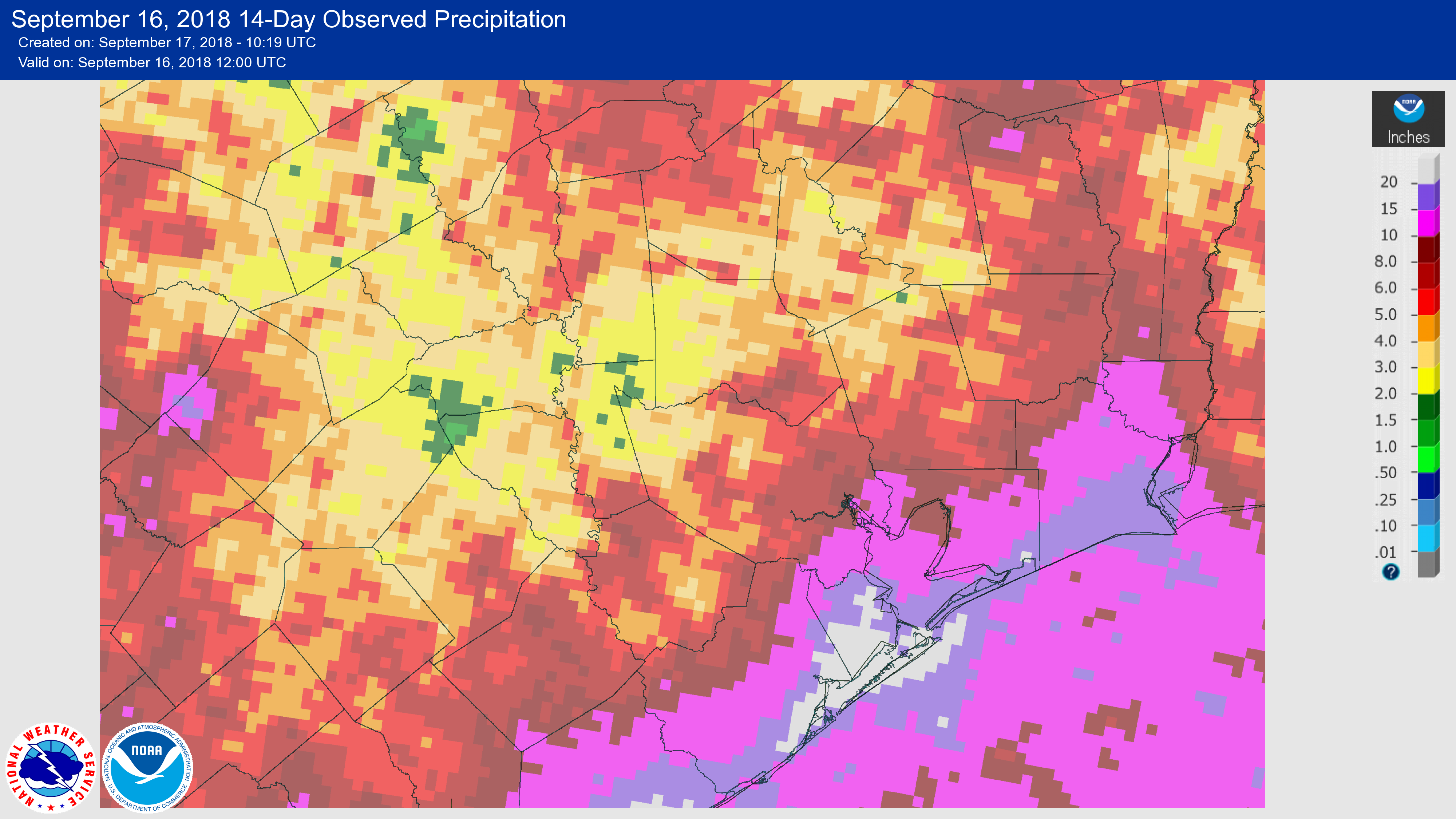
Houston has generally been dry since Saturday, with partly to mostly sunny skies this week for much of the area. This has been due to high pressure overhead, which has kept some of the Gulf of Mexico moisture at bay, and prevented it from rising into the atmosphere, condensing, forming clouds and—you guessed it—producing rain showers. After today, however, this high pressure will begin sliding to the east.

High pressure (deeper reds) will move east by Friday or so. (right panel). (Weather Bell)

The net effect of this will be to increase moisture levels to above normals, essentially opening up an atmospheric river streaming in from the Gulf of Mexico into the Texas coast. This, combined with some anticipated disturbances in the upper-atmosphere, will once again allow for the development of rain showers.

We don’t have a signal for anything too extreme right now, but rainfall should be widespread enough, and perhaps intermittently heavy, to put a damper on outdoor activities during the Friday through Sunday period.

Animated GIF of atmospheric moisture flowing into Texas on Saturday. Lighter blues indicate deeper moisture. (earth.nullschool.net)

Wednesday

Before the rain chances increase, we’re going to see another warm and mostly sunny day. I don’t think we’ll quite reach the 97 degrees we saw on Tuesday, but a lot of the region probably will get into the mid-90s.

See full post

We think we may see the first fall cold front in the distance

It’s time. If we define the “first fall cold front” as a nighttime temperature of 65 degrees or below at Bush Intercontinental Airport, then the average date of Houston’s first front is today, September 18. Alas, we’re not going to make it this year, but there are some hints in the models of a front pushing through before the end of this month (more on that below). That would be a good thing, because based upon Houston’s weather history, we only get into October without a “first front” about once every 10 years. And no one wants that to happen, do they?

Climatology of Houston’s first 65 degree night in the fall. (Brian Brettschneider)

Tuesday

Expect a mostly sunny day today, with high temperatures in the low- to mid-90s. This is kind of a classic summer day, and as there won’t be that many more of these this year, be sure and enjoy it if this is your thing.

Wednesday

A day like Tuesday, but with possibly a few afternoon showers and thunderstorms. Expect these to be fairly isolated, however.

See full post

After weeks of heavy rain, Houston’s weather to settle down for awhile

The city of Galveston started September with a 12-inch deficit in annual rainfall, and now, a little more than halfway into the month the city has a nearly 5-inch surplus. The last two weeks have been incredibly wet for the island, and the southern half of the Houston region as tropical moisture has surged into the area.

Galveston temperature and rainfall (bottom) plot for 2018. (National Weather Service)

The image below, showing rainfall over the last 14 days, demonstrates how the coastal areas have been inundated, whereas some inland areas have received as little as 1-2 inches. While these rains—in excess of 20 inches for locations along the coast—have caused some flooding problems they have not been too widespread. This is because the region can handle 20 inches of rain over two weeks. It’s the 20 inches of rain in two days that causes major problems.

14-day rainfall totals for the Houston metro area. (NOAA)

While we are not done with rainfall entirely, I think it is safe to say we are likely done with the threatening, heavy tropical rainfall for awhile. Good riddance.

Monday

A partly to mostly sunny day today, with only isolated to scattered showers later during the afternoon hours. The sunny skies and lack of precipitation should allow temperatures to nudge up into the mid-90s for most parts of the Houston region. Summer, alas, is not quite ready to loosen its grip.

See full post

End is nigh for heavy rain, but it’s not here quite yet

Did thunderstorms wake you up? A band of rainfall related to a disorganized tropical disturbance moving into South Texas blew through the Houston region this morning, bringing heavy rains and some really loud thunder cracks. This band has weakened now, but a few more storms will rotate through the area today before the westward moving system clears the area. After this we will see mercifully waning rain chances for awhile.

Friday

Looking at the radar, a mass of storms associated with the tropical disturbance can be seen moving steadily westward. However, Houston will remain on the northeastern periphery of the disturbance today, so we can expect to see more showers rotate through. Right now we don’t anticipate anything too extreme, but areas that pick up 1 to 2 inches of rain in an hour can probably expect to see some street flooding, which is most likely for areas between downtown Houston and the coast, and southwest of the city.

(National Weather Service)

The National Weather Service has a flash flood watch in place for coastal counties that expires at Noon today. They may extend it through this evening as a precaution. We can probably expect the heaviest rains to die down by this afternoon or this evening.

See full post