Dry and mostly sunny through Saturday—gray thereafter

Houston’s weather will offer something for most people over the next week or so. Through Saturday, we’re going to see partly to mostly sunny weather, with gradually warming weather as temperatures climb through the upper 70s to perhaps 80 by Saturday. For early next week we’re going to abruptly transition back to the cold, gray, and possibly wet conditions more common during winter.

Wednesday

After this morning’s cold start, highs today will get into the mid- to upper-60s for what should be a banner day under full sunshine. As winds begin to return from the south tonight, overnight lows will only fall into the lower 50s for most of the region.
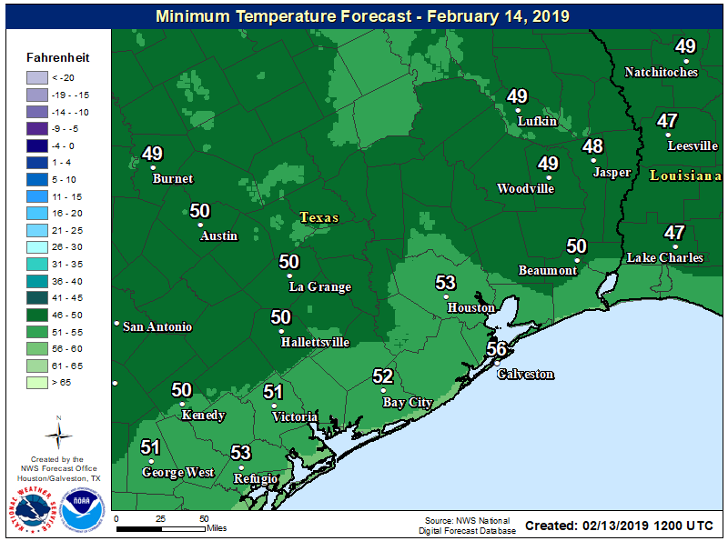
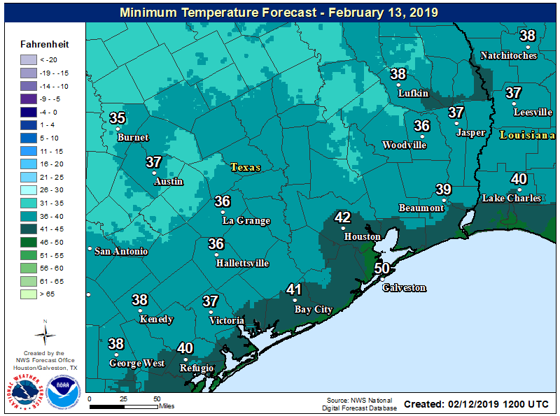
Low temperatures for Wednesday night will be more moderate. (National Weather Service)

Thursday and Friday

The overall pattern will remain mild through the end of the week, as the movement of air in the mid-levels of the atmosphere moves generally from west to east, keeping our region dry. The net result of this should be partly to mostly sunny skies, with highs in the 70s, and nighttime temperatures in the upper 50s to lower 60s. 

See full post

Houston, are you ready for some sunshine?

The last of the rain showers associated with Monday night’s cold front are pushing through the coastal areas, and drier air is flowing into the region from the northwest. After days and days and days of mostly cloudy conditions, Houston should now see a nice stretch of mostly sunny and dry weather.

Tuesday

Areas well inland, near Conroe and College Station, are already seeing clear skies this morning, and this general trend will move into Houston and the coastal areas later this morning with the influx of drier air. The clearing skies should allow highs today to get into the mid- or upper-60s. The primary concern will be winds, which could gust up to about 20mph as the front pushes in. Temperatures tonight will drop down to near 40 degrees in the city, with cooler conditions further inland, and a bit warmer near the coast.

Lows Tuesday night will be the coldest of the week. (National Weather Service)

Wednesday

A beautiful, mostly sunny day with highs in the mid-60s. As a more southerly flow returns later in the day we can expect more moderate nighttime temperatures about 10 degrees warmer than Tuesday night.

See full post

After a front, this week should be drier and sunnier for Houston

The first 10 days of February have been mostly cloudy, with intermittent light rain showers. Monday will be no different, but after a cold front sweeps through Houston tonight, we should finally have a stretch of drier weather, with several days of partly to mostly sunny skies. The coming weekend, for a change, also looks quite nice in terms of temperatures and sunshine.

Monday

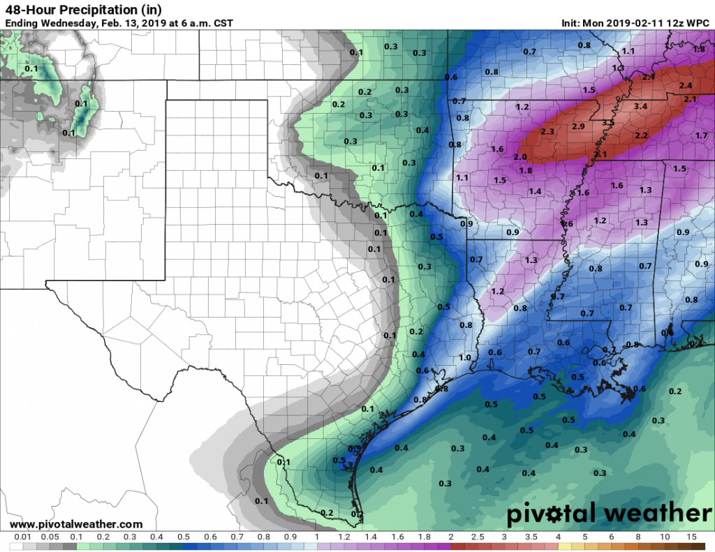
In advance of the front, muggy and warm air is holding sway, and because of this we’re again seeing some areas of fog where this warmer air is moving over cooler waters. Skies again today will be cloudy, with scattered, light showers during the daytime. Rain chances improve later this afternoon and during the evening hours, as low pressure ahead of the cold front moves into Houston. Accumulations likely will be highest near the coast, where there is the most moisture to work with, and as much as 0.5 to 1.0 inch of rain could fall. Severe weather is unlikely with the frontal passage.

NOAA rain accumulation forecast for Monday and Monday night. (Pivotal Weather)

Tuesday and Wednesday

This time, the front will be deep enough to scour clouds from the region. Tuesday, and at least part of Wednesday, should see partly to mostly sunny skies. These will be fine winter days, with highs in the low- to mid-60s. Tuesday night will be cool, perhaps getting down to around 40 in Houston, but by Wednesday night things will be warming up as the onshore flow resumes.

See full post

February 2019 picking up where February 2018 left off: Dreary

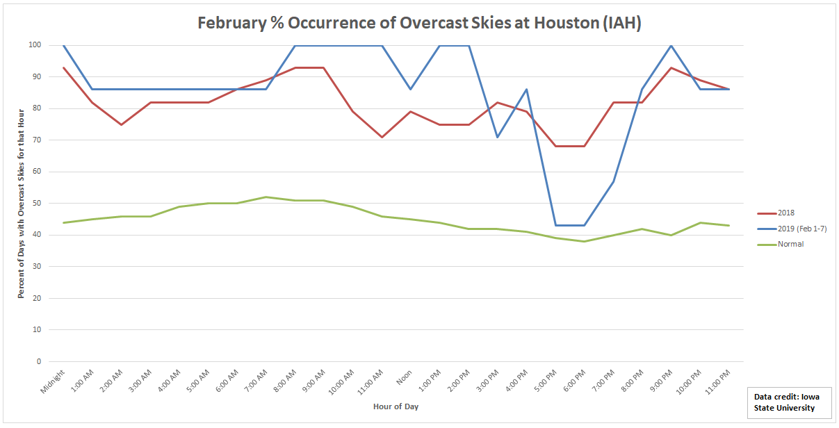
February is not Houston’s prettiest month, at least not recently. In February of 2018, 82% of all observations at Bush Airport reported some degree of overcast skies. “Overcast skies” in this case would be defined as any observation reporting “OVC” for the cloud deck. That could be anything from a high, thin overcast with some sun peaking through to low, gray clouds or fog. Either way, some sort of grayness to the sky.

This February is picking up where February 2018 left off, with lots of clouds around. (Data via Iowa State University IEM)

So far in February of 2019, we’re averaging 85% of observations featuring overcast conditions. Typically in February, Houston averages about 45% of observations with overcast skies. Basically, with the exception of the time right around sunset, it’s been gloomy so far this month for the second year in a row. And this weekend will not help that cause.

Today

Winter is back in force today. How far has the temperature fallen since this same time yesterday morning?

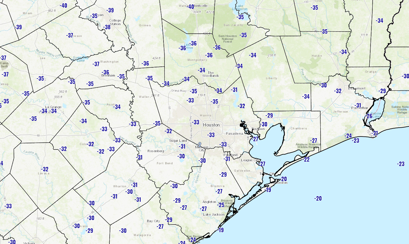
Temperatures are about 35° colder on average than they were this time yesterday across the Houston area. (NWS)

In Houston, we are running about 35 degrees colder than at this same time yesterday morning, starting today in the upper-30s or low-40s. Changes are a little greater north and a little less so south. Temperatures won’t move much today. Expect highs in the low-40s at best with a bit of a gusty north wind continuing.

Cloud cover will dominate today, with perhaps a few sunny breaks if we are lucky. In addition, we could see some sprinkles or light rain, especially along the immediate coast, as well as north of the Houston area, up toward Conroe or Huntsville. Up north, any of that light rain could mix with or even fall as ice pellets (sleet). It would be conversational, not impactful, but a good reminder of where we sit on the calendar.

See full post