Houston feeling the El Niño pattern this winter

After a stretch of intermittently sunny weather, with mostly rain-free days, Houston now returns to a more gloomy pattern. Several readers have asked why this winter has been so wet and gray, and the reason is generally due to the recent formation of a weak El Niño in the equatorial Pacific Ocean. This pattern generally favors a wetter winter, and that’s precisely what we’re going to get for the rest of February, at least. (El Niño is not expected to continue into the summer, so it’s unlikely to affect the 2019 Atlantic hurricane season).

January was a typical month during a weak El Nino, with 1-2 inches of rain more than normal for most of Houston. (National Weather Service)

Tuesday

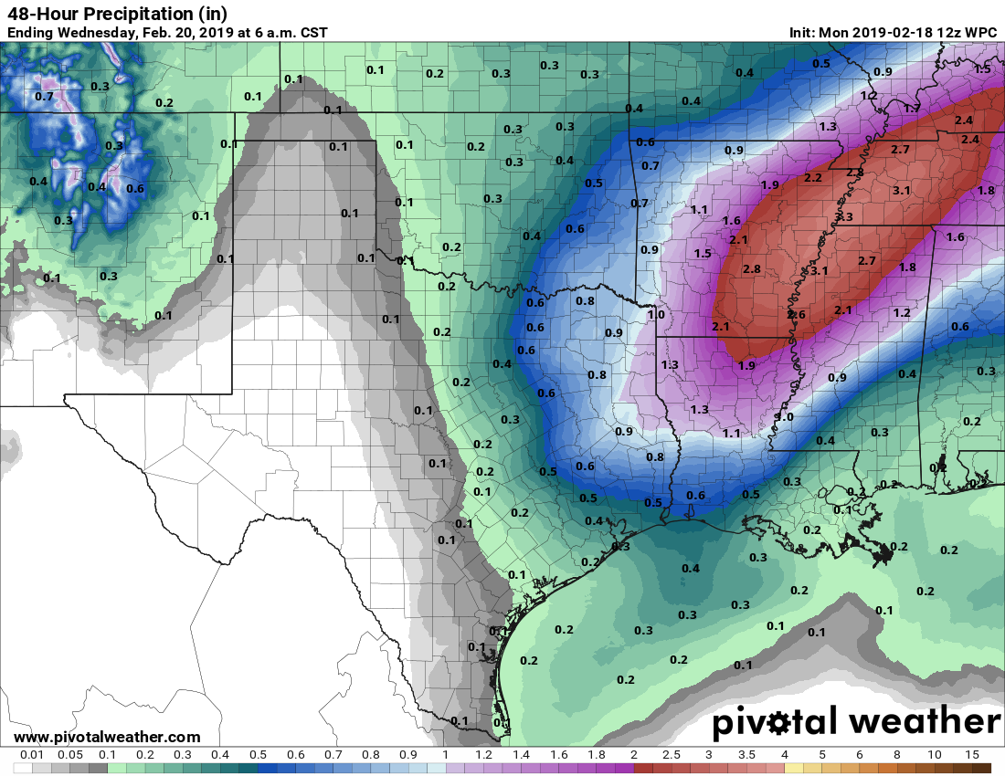
Today will be especially wet and gray, with near 100 percent rain chances for Houston. Until around sunset, bands of light to moderate rain will pulse into the region from the Gulf of Mexico as an upper-level storm system moves through the area. While conditions for heavier rain are better to the east and northeast of Houston (parts of Arkansas could see in excess of 3 inches of rain), for our region we expect most areas to receive under 0.5 inch today. Still, it will be cloudy, and cold, with highs unlikely to reach 60 degrees. Lows Tuesday night will probably fall to around 50.

Wednesday

This has the potential to be a nicer day. Sometime early Wednesday, a cold front associated with Tuesday’s rain showers will push through Houston. This will be a relatively weak front, but it should bring some drier air, and therefore rain chances for the daytime on Wednesday are fairly low. We may also see some sunshine during the afternoon and evening hours as highs rise into the low 60s.

See full post

Rodeo on the horizon, and the forecast is mostly gray

Skies are partly clear across the region this morning, but clouds will increase throughout the day, and I’m afraid we’re looking at mostly cloudy skies for the remainder of the week. We’ll also see healthy rain chances through Friday or Saturday—which means less-than-ideal conditions for the upcoming Houston Rodeo Cook Off, and part of the opening weekend for Mardi Gras in Galveston. We’ll dive into this in greater detail below.

Monday

With Sunday’s cold front well offshore, we’ll see a breezy, cool day today, with highs in the upper 50s and lower 60s. This is probably also the last day with near-zero rain chances until Sunday as conditions turn wetter. Temperatures tonight will drop to around 50 degrees—cooler inland and warmer near the coast. The wetter pattern should begin as soon as this evening, as light rain showers migrate inland.

Rain accumulation forecast for now through Tuesday. (Pivotal Weather)

Tuesday

Broadly speaking, our pattern for much of this week will be one of a thin layer of colder air at the surface, and a warmer, moist current of air from the southwest higher up in the atmosphere. Tuesday looks especially wet, with a saturated atmosphere and near 100 percent rain chances. The heavier rain should remain largely to the northeast of Houston, with the metro area generally seeing about one-half inch of rain. All told, this will be a cold (mid-50s), damp day.

See full post

Soon heading back in the clouds for a little while

We are heading back to being mired in a weather pattern that is generally low impact (aside from some fog) but also fairly obnoxious: Lots of clouds, cold fronts that will shift temperatures in a big way depending on where they’re situated, and plenty of rain chances but ultimately not a lot of rain accumulation. Let’s dive in.

Today

Areas of fog, locally dense, have developed this morning, and there is a Dense Fog Advisory through 9 AM for most of the area. Give yourself a couple extra minutes out the door today. As fog lifts, expect a good deal of cloud cover this morning, giving way to some partial afternoon sunshine at times. High temperatures today will be contingent on sunshine. With a lot of sun, we could make a run for 80° in spots, particularly west of I-45. With clouds hanging on, expect upper-70s in most places. Some fog may roll back into coastal communities later this afternoon.

Saturday

The forecast for tomorrow is tricky. The first in a series of cold fronts will get down to about US-59 in the morning.

You can clearly see Saturday’s cold front when looking at forecast dewpoints from the NAM model. It’s basically along US-59 at 7 AM. (Weather Bell)

Using the image above (which shows dewpoints instead of air temperatures), you can see the cold front is conveniently right along US-59. This is from the NAM model, which is probably the most aggressive of the models in bringing this front south. In fact, this may even be a smidge too far south and east. But I want to show you how sharp a cutoff this is between very warm humid and potentially cooler and drier.

The front will likely make limited progress south and may even begin to retreat a bit back to the north in the afternoon. Ahead of the front, we will see areas of dense fog along the coast or in the bays once again for much of tomorrow. Temperatures will likely be in the 70s to perhaps near 80° again. North and west of Houston closer to the front in the afternoon, look for mid-70s. There is a small degree of uncertainty tomorrow. If the front is able to be aggressive and dives southeast enough, some areas north or west of US-59 may only see highs in the 60s Saturday.

The good news is that rain chances look limited on Saturday. There may be a few showers or sprinkles along the coast, but otherwise, it just looks mostly cloudy tomorrow (foggy along the coast).

See full post

Houston forecast sunny though Saturday, then things turn murky

Our forecast remains on track through the first half of the weekend, with mostly sunny conditions and warmer weather. After this, however, our weather turns a bit murky both literally and figuratively as a cold front stalls out near, or over the region. Certainly we’re not expecting anything too extreme, but for now the forecast is hard to parse with any great detail.

Thursday and Friday

The work week will end with a pair of fine, partly to mostly sunny days, with high temperatures generally varying from the low 70s to the upper 70s depending upon cloud cover. Nights will be moderate, with lows in the upper 50s for inland areas ranging into the low 60s for the coast. Rain chances are near zero and humidity levels will be reasonable with some drier air mixing in.

Friday will be a warm day, especially for Central Texas. (National Weather Service)

Saturday

The first half of the weekend will see more of the same, although cloud cover may increase some later during the day on Saturday. This still should be a dry day for most, with highs in the mid-70s, so plan those outdoor activities with confidence. Nighttime temperatures on Saturday will be quite warm, likely in the 60s pretty much area-wide.

See full post