Another chance for storms before a quieter weekend

For parts of Houston, yesterday was a dry sandwich on rain.

Rainfall was prevalent both north and south of Houston, but not so much in town. (Harris County Flood Control)

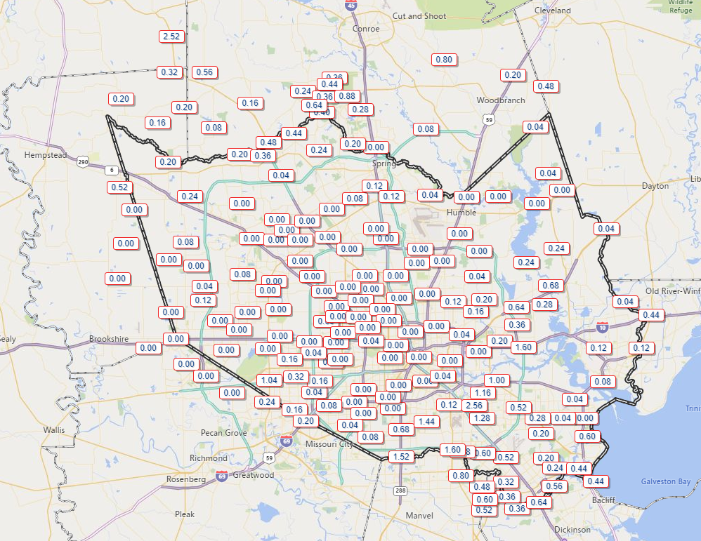
How’s that, Matt? Well, from the map above, you can see The Woodlands had just shy of an inch of rain in spots from morning storms. Grimes County even checked in with over 2.5 inches near Navasota. Other locations from northwest Harris into Montgomery Counties also got measurable rain. Then, south of Houston, afternoon storms deposited over 2 inches near Hobby Airport and over an inch down toward Pearland, with some more rain in other spots. Inside Houston, it was mostly dry. The east side saw some showers, but rains were mostly limited for the Inner Loop and north and west of town. We will take another swing at some rain chances today.

Today

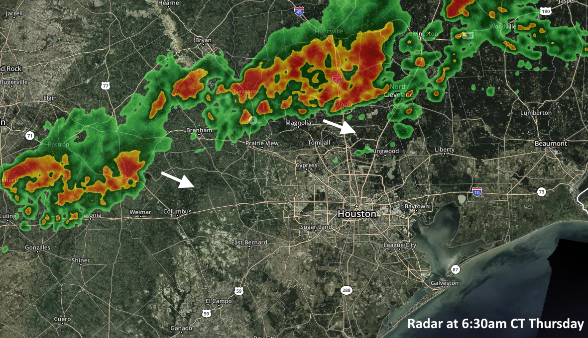
Radar is quiet around the Houston area this morning, with just a few dying showers to our south.

Radar is quiet around Houston, but there is a healthy cluster of storms west of Fort Worth and near Abilene. Those could impact places like Bryan or College Station by early afternoon. (College of DuPage)

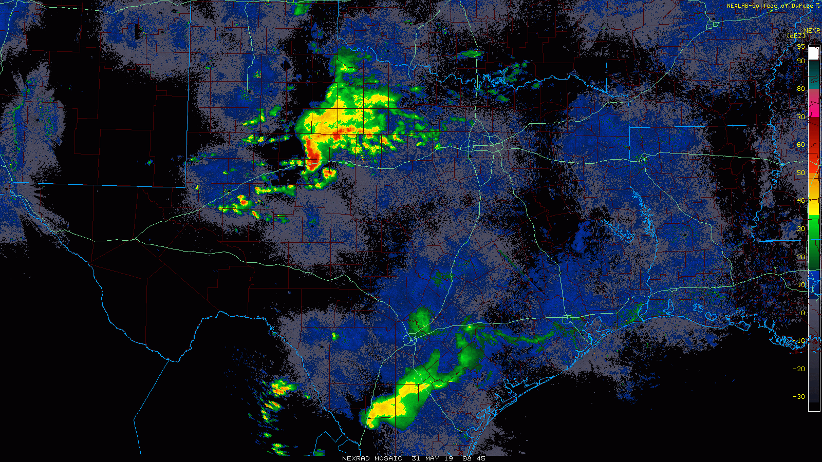
The more impressive storms this morning are near Abilene and west of Fort Worth. Look for that cluster of storms to drop southeast through the morning, possibly arriving far northwest of Houston near College Station by early afternoon. At the same time, a new scattering of storms should develop in and around Houston after 12-1 PM or so. So, the bottom line today: Expect a mostly quiet morning, with scattered storms this afternoon. Those under the most persistent storms later today could see two to three inches of rain in a short time. But also like yesterday, some folks in the area won’t see any rain at all. Have an umbrella for later, just to be safe.

Before and outside of any storms, temperatures will top off within a degree or two of 90 by early this afternoon.

Weekend

We shouldn’t see much more than a passing shower or two in the area for Saturday and Sunday. Most of us will be dry the entire weekend. Look for partly to mostly sunny skies both Saturday and Sunday. Temperatures will begin to heat up a notch further, with low 90s likely during the day away from the coast and upper-80s in Galveston. Nighttime lows will generally be in the lower of middle 70s inland and mid- to upper-70s along the coast or bays.

See full post

Storms possible Thursday as a dying front sags into Houston

We’re going to see a potentially dynamic day of weather on Thursday as a dying cold front approaches the metro area. Friday will be a transition day before high pressure clamps down on the region over the weekend and beyond.

As a weak cool front sags down toward the Houston area this morning, a broken line of moderate to strong showers and thunderstorms will move with it. As of 6:30am CT, this line stretches from Luling to Navasota to Huntsville, but it should gradually move the east-southeast, and into the Houston area.

Radar at 6:30am CT Thursday. (kktv.com)

Based upon high-resolution modeling, it appears as though the best rain chances will be north of Interstate 10 this morning, along the highway and through the central Houston area during the middle of the day, and closer to the coast later this afternoon and early evening. I think these showers will be pretty hit-or-miss, meaning that some areas will probably only get a smattering of rain while a neighborhood a few miles away gets lots of lightning and  1-, or 2-, or even in a few isolated cases perhaps as much as 3-inches of rainfall. Because some of these isolated cells may produce some heavier showers, we can’t rule out some street flooding throughout the day under the strongest storms. Rains should end by around 6 to 8pm for most of the area.

Cloud cover today should help limit high temperatures to the upper 80s or around 90 degrees.

See full post

Healthy rain chances Thursday, mid-90s by the weekend?

Over the last 10 days Houston experienced its first taste of multiple 90-degree days in succession, and the next step function will come when we move into the mid-90s. For Houston, highs in the mid-90s are proper hot, meaning these temperatures are characteristic of mid-summer in Houston. It can get hotter, certainly, but the mid-90s are the bread-and-butter of summertime in Houston. We’re likely to get our first taste of them this weekend, as high pressure settles over the area.

Wednesday

It’s breezy this morning, with fairly strong southerly winds that could gust above 20mph today as they bring moisture into the area. A few scattered, light showers may pop up later this morning, but skies should nonetheless clear out this afternoon, allowing high temperatures to push up to around 90 degrees. Lows tonight will fall into the mid-70s except for the coast, which will be warmer.

Storm outlook for Wednesday and Wednesday night. (NOAA)

If you’re traveling to the Dallas-Fort Worth area today, a cold front will be moving through North Texas, and bringing potentially quite severe weather (with the usual threat of damaging winds, hail, and tornadoes). This weather should remain north of the Houston area on Wednesday, but could move into the College Station area by around midnight or shortly thereafter.

See full post

May was a month of two halves: Floods then dry as a bone

There’s a lyric in a Steve Earle song called The Rain Came Down that reminds me of Houston’s weather every time I hear it: “It’ll wash you away and there ain’t never enough.” Such was the case for Houston during the month of May, with heavy rainfall and significant flooding during the first two weeks of the month followed by almost nothing since then. The map below shows rain totals over the last two weeks for the greater Houston area.

Rain totals during the last 14 days. (NOAA)

The schism in May rainfall also represents the transition from spring storm season to summer, as high pressure more or less clamped down and temperatures shot up—seven of the last nine days have had high temperatures of 90 degrees or above. We may see a bit of a reprieve from high pressure this week, but as we get deeper into June we can expect more of it.

Tuesday and Wednesday

Conditions for the next couple of days won’t change much temperature-wise for Houston. We probably will see high temperatures of around 90 degrees, with a mix of partly sunny mornings, and mostly sunny afternoons. We can’t entirely rule out a few showers streaming in from the coast, but chances probably will only be 10 to 20 percent for both days.

See full post