A major line of storms pulsed through the Houston area early Saturday—but well before sunrise they pushed to the east of the region. Some lingering showers are possible later this morning, but for the most part we should be dry from here on out. The overnight storms dropped 1-2 inches of rain, and may have spawned a tornado.
Now, however, we should see a nice May weekend. Clouds should eventually break apart this afternoon, leading to a pleasant evening, with inland parts of the region potentially seeing lows in the upper 60s. Sunday should see mostly sunny skies, with highs in the upper 80s to 90 degrees.
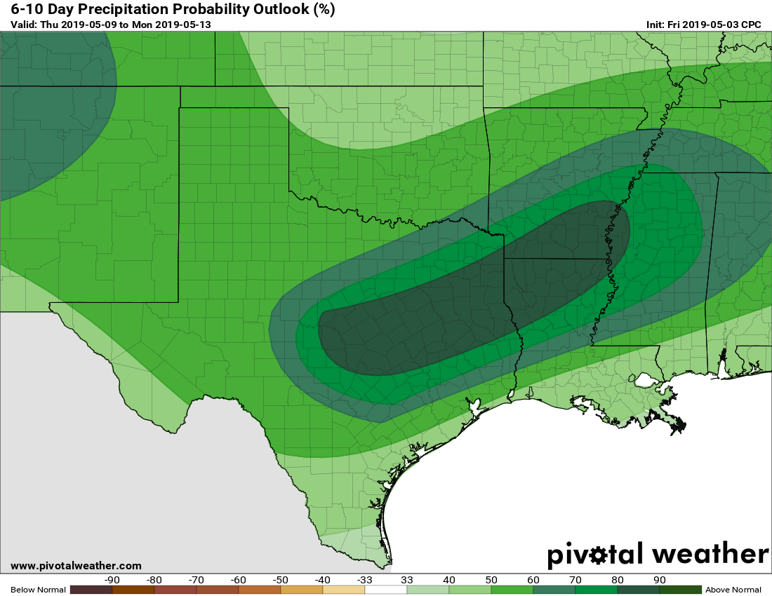
The end of next week does look wet. (Pivotal Weather)
As Matt mentioned Friday, the coming week looks potentially quite wet, especially the period from Thursday through Saturday. It’s too early to have too much confidence in the timing and details, but a slow-moving front could make for very wet conditions, with multiple inches of rain and the potential for at least some street flooding. But we wouldn’t worry too much about that yet; for now enjoy the weekend and we’ll provide a full (and hopefully clearer) update of the situation on Monday morning.
Some active weather is likely to continue over the next 24 hours, so we’ll get right into that before talking about a mostly nice weekend to follow.
Early morning Friday
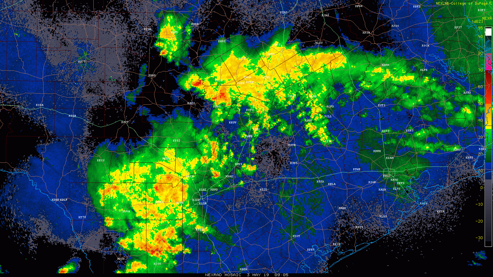
Radar as of 5:40 this morning, shows minimal amounts of showers around Houston. There’s some rain well to the north of Conroe that is falling apart.
The bulk of the rain this morning is west of Houston. That is what we will watch later this morning and this afternoon. (College of DuPage)
Scattered showers and storms were pressing east of Austin, more toward the Brazos Valley. Heavier rain and storms (non-severe) in San Antonio were sliding east toward Victoria and places west of Houston. Over the next few hours, these showers will gradually migrate toward Houston, but for the most part, our early morning looks fairly quiet.
Friday late morning & afternoon
Weather modeling has been some kind of inconsistent over the last couple days in terms of what and where with rainfall. So to some degree, this leaves us flying partially blind today. We can tell you a couple things with confidence: First, there will be plenty of moisture available for storms today. This is probably the most we’ve seen all week, so it should mean coverage of storms today will be at their highest of the week for Houston. Second, we need a trigger, and with numerous boundaries in the area and more coming from the San Antonio area, that should be enough to get showers and storms going later this morning and this afternoon.
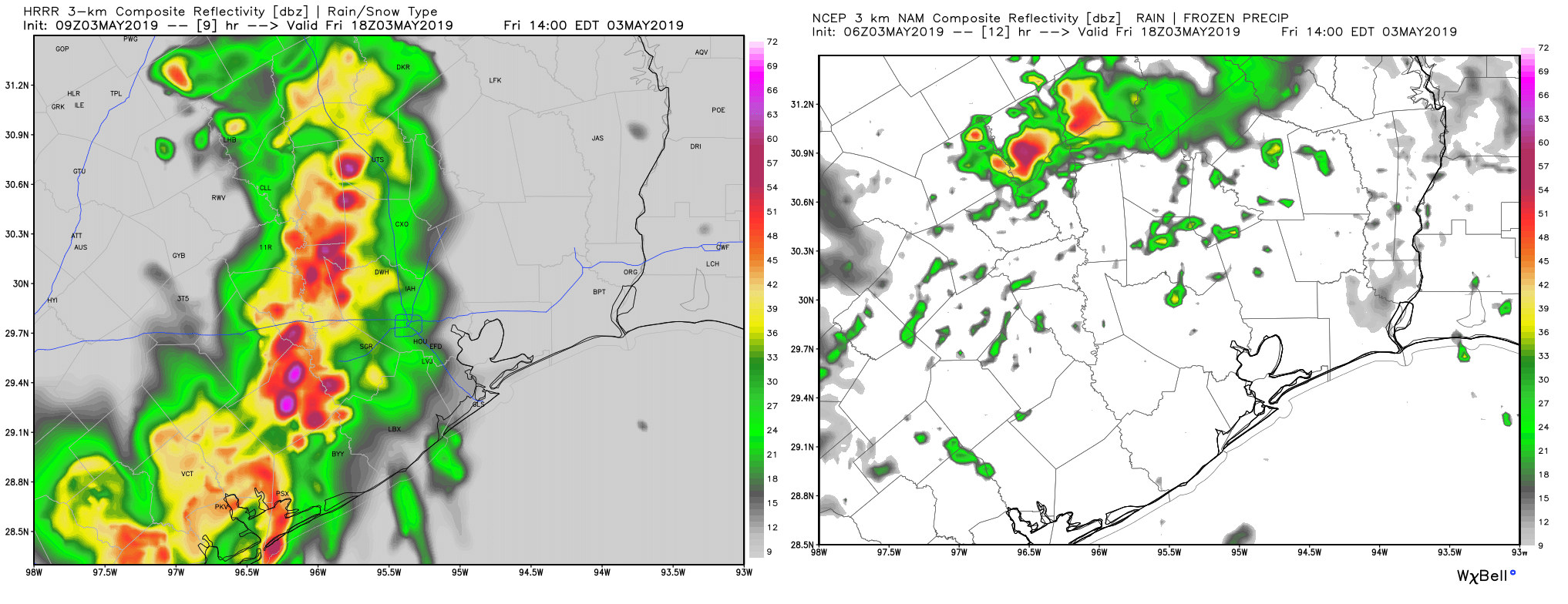
Two images of radar depictions from two models valid at 1 PM today shows a stark difference between the HRRR (L) and NAM (R). I’m showing this less due to specifics and more as an example of model struggles we are fighting. (Weather Bell)
What we cannot tell you with much specificity, and what is naturally most frustrating to us (and you I’m sure) is exactly where and when the heaviest rains will occur. The image above is a sample from two short-range, high resolution models we look at each day. They are valid for the same time: 1 PM this afternoon. The HRRR (at left) shows an organized heavy cluster of storms. The NAM (right) shows scattered showers. I am leaning toward the HRRR idea right now, but basically at this point, the best advice we can give you is to bring an umbrella and be ready to potentially deal with some storms and heavy rain from late morning into this evening.
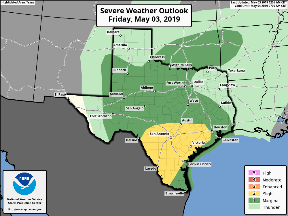
Severe weather is possible today, but the best chances will be south and west of the Houston area. (NOAA)
In terms of severe weather, it is possible we see some strong winds or hail, but the biggest concern with these storms will be heavy rain and localized street flooding. Any storms could produce rain rates of 1-2″ per hour or more which, if over one place, could lead to some street flooding.
Houston faces a couple of wetter, and potentially stormy days before our weather clears out sometime on Saturday, and brings us what looks like a fairly nice May weekend. But first we’ve got to get through a round of storms this morning, for the northern half of the region, and then a stormy period on Friday night. We’re not anticipating anything too severe, but we could see some at-times strong thunderstorms.
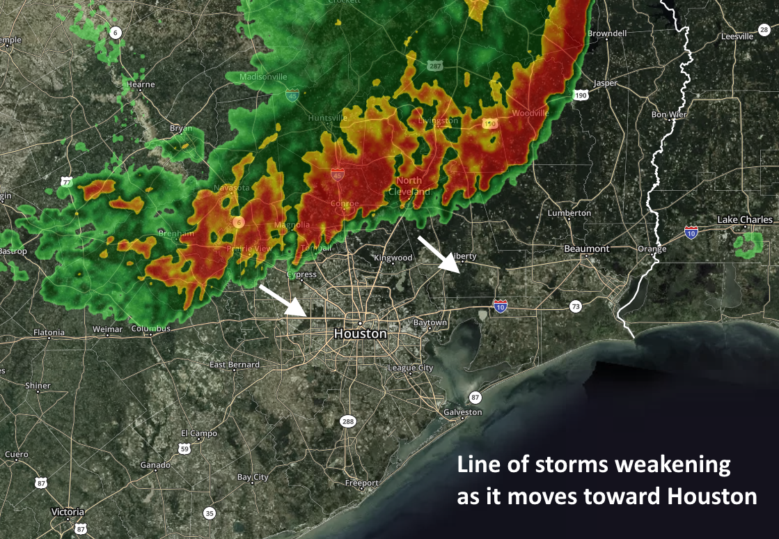
Houston radar at 6:30am CT. (kktv.com)
Thursday
As of 6:15am CT, the northern part of Houston is seeing the remnant line of showers and thunderstorms from a large storm system that moved through North Texas on Wednesday night. This line is slowly weakening as it moves to the south-southeast this morning, but some part of it will likely push through The Woodlands and down at least into central Houston. Closer to the coast, a capping inversion will likely prevent widespread showers and thunderstorms. After this system works through this morning, we can expect a partly sunny day with highs in the mid-to upper-80s.
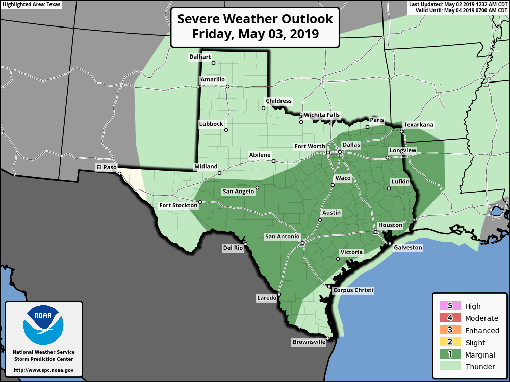
The storm outlook for Friday and Friday night is somewhat supportive of severe weather. (NOAA)
Friday through Saturday morning
We’ll see another wetter period on Friday through Saturday morning for the region. Most of the action should remain to the west and north of the Houston metro area through the daytime hours on Friday, but sometime that evening we should see a mass of storms move through the area roughly from west to east. This system is part of a weak cold front and an upper level disturbance. Timing is still hazy, but generally we’d expect the worst weather overnight for most of Houston, and probably lingering into Saturday morning for the coast and eastern parts of the region. Most modeling shows the system clearing the area by or before noon on Saturday, but we’re offering no guarantees. Generally, the area will probably see 0.5 to 1.5 inches of rain, but there may be higher localized totals, and we can’t rule out some hail and damaging winds.
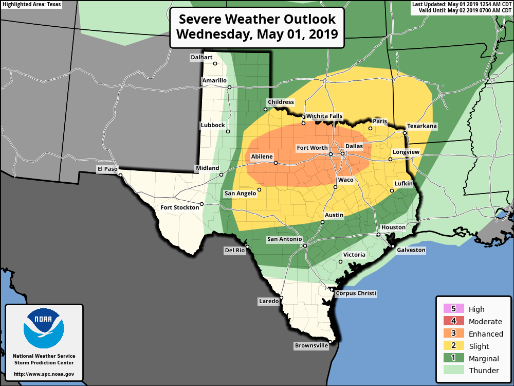
Good morning. Houston will remain in a muggy, partly cloudy, and somewhat rainy period through Saturday, but we have no major concerns. However, the same cannot be said today for northern Texas, particularly the I-20 corridor from Abilene through Dallas and Fort Worth. Severe storms could affect the Metroplex during the afternoon, and evening hours, with the distinct threat of large hail, heavy rainfall, and potentially tornadoes. Please take care if you’re traveling that way today or tonight.
Severe weather outlook for Wednesday. (NOAA)
Wednesday and Thursday
Back in Houston, conditions will be much more sedate. We’re going to continue under a pattern of a warmer southerly flow, with breezy winds from the Gulf bringing moisture into the area. Both Wednesday and Thursday should see some sunshine, which will allow highs to nudge up into the upper-80s for most areas, likely.
The bigger question is rainfall, and I think we’re going to see some light to moderate rain showers over the northern half of the area (think north of I-10), while southern areas remain pretty much dry. Overall inland parts of the region could see as much as one-half inch of rain through Thursday, but it should be nothing to write home about in terms of impacts. Nights will remain steamy, in the low 70s.