Barry moving inland in Louisiana, still just some showers in Texas

Quick overview: Hurricane (now Tropical Storm) Barry made landfall near Intracoastal City, Louisiana this afternoon and is now slowly marching inland over Louisiana. While significant impacts are occurring from central Louisiana through coastal Alabama, we just have a few gusty showers for now in Texas. A more organized area of coastal rain may develop tomorrow and Monday, but details are still somewhat uncertain on exactly how much rain will fall. Either way, we do not expect significant problems at this time, and there are no further tropical concerns to speak of.

Tropical Storm Barry & Houston’s outlook

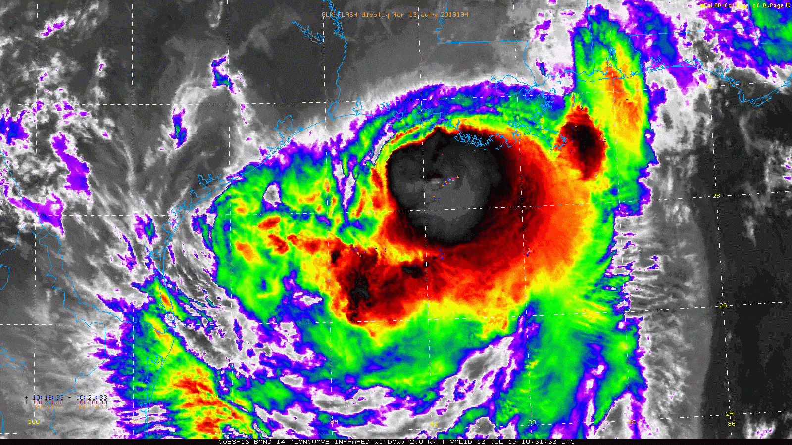
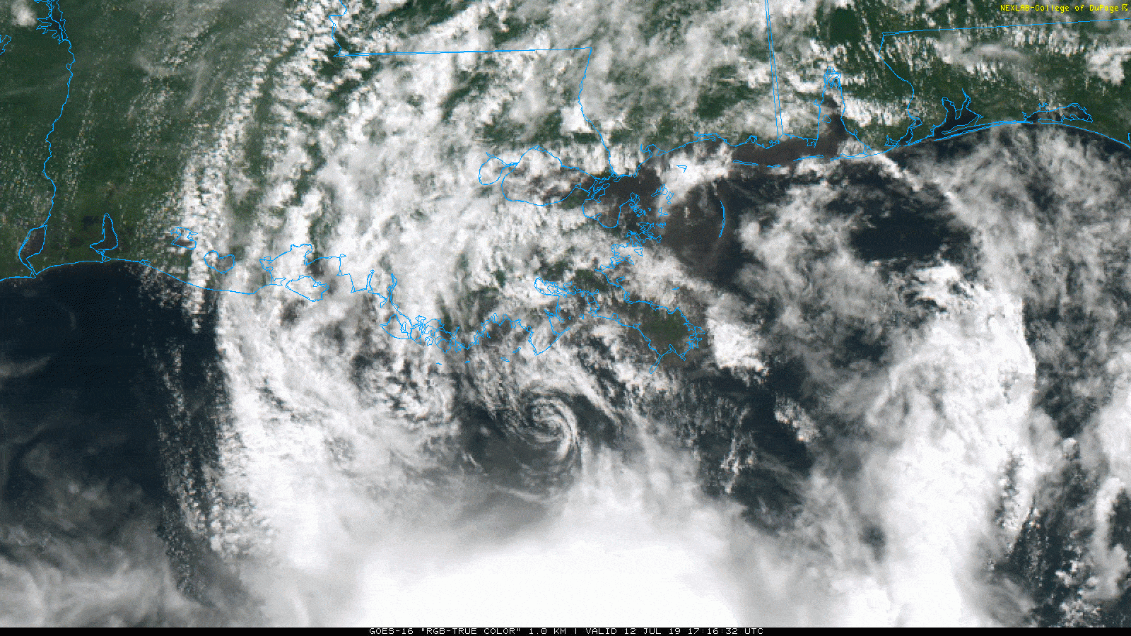
Barry is moving inland over Louisiana this evening, spinning just west of Lafayette.

Tropical Storm Barry is slowly working inland over Louisiana. Offshore clouds indicate heavy rains that will work into Louisiana tonight. (College of DuPage)

Barry will continue a slow drift to the north-northwest and eventually north as we go through the night. All those clouds offshore indicates moisture, all of which will get thrust onshore into Louisiana tonight and tomorrow. Significant rains that have so far been worst in Alabama will begin to cause issues in Louisiana and Mississippi.

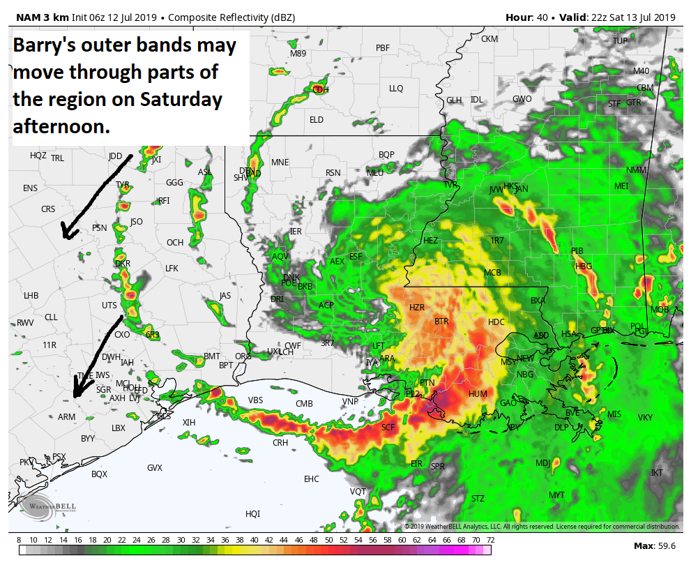
Maximum sustained winds are down to 65 mph, and a slow weakening will continue. Notice just a few bands of clouds on the west side of Barry heading into Texas. We’ve got some of the outer bands moving through Houston this evening. At times tonight, you can expect showers and some gusty thunderstorms, with winds perhaps of 20 to 25 mph, but not much worse.

Radar this evening shows bands of heavier showers pinwheeling through the region. Brief, gusty showers or thunder will be possible at times through the night. (RadarScope)

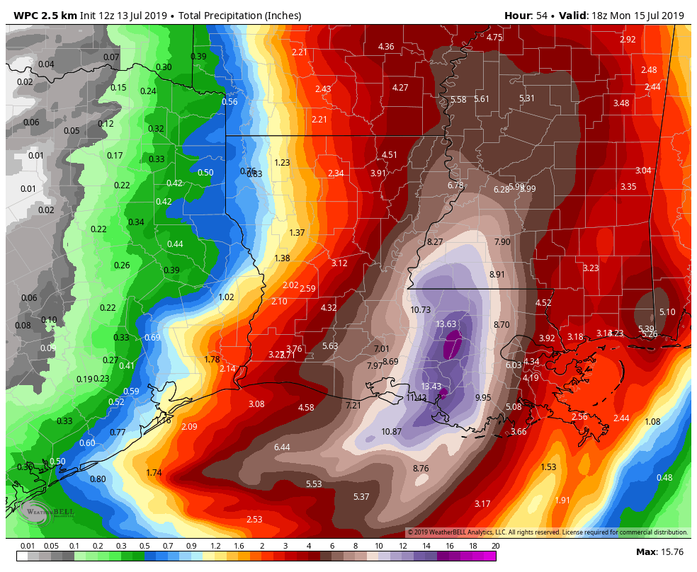
No significant rains or impacts will occur tonight. Tomorrow should start off fair, with no issues expected. A few showers and storms will become possible from mid-morning on. Eventually that could congeal into an organized, slow moving band of heavier rain and storms south and east of Houston, primarily along the coast or just a few miles inland. As such, the Weather Prediction Center has our area is a marginal to slight risk of excessive rain tomorrow.

The NWS Weather Prediction Center has outlooked the area in a marginal to slight risk for excessive rainfall tomorrow. This will be mostly an issue south and east of Houston, though we aren’t especially worried about anything other than minor street flooding at this time. (NOAA)

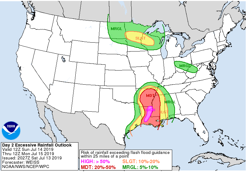
We are not concerned about significant, widespread flooding tomorrow, but we do think that areas south and east of Houston, primarily areas of southern Brazoria County through Galveston County and up the coast toward Port Arthur stand the best chance of seeing a slow moving, “training” band of showers and storms. While this is not a guarantee, if this were to occur, we could see some mostly minor street flooding in places like Galveston or Lake Jackson tomorrow afternoon or evening. Just something to be on the lookout for right now, and we will update you tomorrow on what expectations look like. In general, rain amounts south and east of Houston will be 1 to 2 inches on average, with higher amounts possible. From Houston to the north and west, some places may see up to an inch or so, and others may see nothing at all.

So if you have outdoor plans in Houston or north and west, you can probably go forward with them, but you may be briefly interrupted by some showers. South and east of Houston and at the beach, consider a backup plan in the afternoon in case the steady rain spoils those plans.

Lastly, there have been a lot of rumors and banter and questions about this storm changing course or that thing 3,000 miles out in the Atlantic becoming a threat. That’s just not true. No reliable modeling shows the thing in the Atlantic even surviving into the Caribbean, let alone all the way to Texas. And the track of Barry has been pretty much set in stone since yesterday or even Thursday, truthfully. So you have absolutely nothing to worry over right now. More tomorrow.

Barry approaching landfall on the Louisiana coast

Tropical Storm Barry is flirting with hurricane intensity this morning south of Morgan City, LA. Maximum sustained winds are 70 mph, and it’s possible Barry could cross the finish line as a hurricane. Landfall is expected somewhere on the west side of Vermilion Bay, LA this afternoon.

Barry still has most of its moisture and storms south and east of the center, but its visual presentation belies its true intensity. (College of DuPage)

Moving forward, Barry will slowly move inland over Louisiana, and all those bright clouds that indicate thunderstorms are going to come ashore in Louisiana. It’s been mostly nuisance rain there so far, but it will escalate significant later today or tonight. Storm surge flooding is an ongoing issue across much of eastern Louisiana.

We will continue to see these problems through the day, and then the rainfall will begin to cause problems tonight.

How much rain?

Total rainfall is expected to be highest between Lafayette and New Orleans, potentially focused on the Baton Rouge area. (NWS WPC via Weather Bell)

Well, according to the NWS Weather Prediction Center, most of eastern Louisiana should see four inches or more of rainfall, with the bullseye between Lafayette and New Orleans of 10 to 15 inches. This bullseye may end up near the Baton Rouge area.

This serves as a nice breakpoint for us to shift gears and talk about Texas. That official forecast shows 1 to 2 inches through Monday afternoon between Galveston and Beaumont, with lesser amounts north and west of there. Let’s break things down a bit.

See full post

Barry looking healthier, forecast virtually unchanged

If you’re a more weather savvy Houstonian, you’ve spent a chunk of the day with a satellite loop of Tropical Storm Barry open in a browser tab, checking it periodically and perhaps feeling a bit uneasy. And that’s completely understandable. The good news is this: Despite what your eyes are telling you, everything, forecast-wise, is still on track, and Barry is expected to move into Louisiana tonight and tomorrow.

Here’s what I’m talking about:

You thought that little swirl was the center about to make landfall? Nope. It’s a small part of the larger, broader center to the south that is slowly moving west and will turn northwest tonight. (College of DuPage)

From the above satellite image, you can see the adorable cinnamon bun-esque swirl south of the Louisiana coast today that now appears to be moving back southwest. Believe it or not, that is not center of Tropical Storm Barry. That is what we call a “mesovortex” swirling around the broader center that is to the south and will gradually turn to the northwest tonight. As Barry organizes a little bit healthier tonight, you’ll probably begin to see a slightly more traditional satellite presentation try to evolve. Wind shear will continue to limit how well organized Barry can become, but it would seem likelier than not that Barry becomes a hurricane tonight before making landfall tomorrow near Vermilion Bay. The turn will happen, we just need to be patient.

Impacts are mostly unchanged, with major rains expected to slog inland tonight and tomorrow over Louisiana and Mississippi. Heavy rain is likely between Lafayette and New Orleans, though the more recent rainfall forecast have backed down a bit in NOLA, which is good there, but a lot of rain is going to fall upstream over the Mississippi. Maximum totals should be 15 to 20 inches, probably not far from Baton Rouge.

The heaviest rainfall now looks to be west of New Orleans but still across eastern or central Louisiana. (NWS via Weather Bell)

This morning I discussed the possibility of heavier rain potentially near Galveston or the Bay Area. Basically, we expect some type of inflow band, or an area of converging winds to setup near the coast tomorrow night and much of Sunday. If that happens, locally heavy rain will be possible, particularly along the immediate coast. The rainfall forecast above shows about 1 to 2 inches potentially near Galveston, with less as you come inland. We will have to refine this tomorrow a bit, just in case the heavier rains stay offshore or to our east, or alternatively look heavier over Galveston. For now, in Galveston, expect a forecast of persistent rains on Saturday night and Sunday with occasional showers or clouds inland from there. Saturday is probably a satisfactory beach day, but Sunday may be a loss. We will reassess how things look in the morning and offer you another update then.

Barry stays east but rains could impact coastal Texas this weekend

The forecast today will be one of heat, followed by a somewhat uncertain outlook this weekend. Let’s walk through things, and then we will touch on Louisiana and Barry.

Today

The expectation right now is that today will be a mostly dry day in Houston. That said, I cannot entirely rule out some showers late this afternoon coming in off the Gulf along the coast or out of Louisiana for folks east of I-45. As long as it stays mostly dry though, it’s going to be awfully hot once again today. We should make a run for the upper-90s.

It’s going to be very hot today, even along the coast, where offshore flow will limit a cooling sea breeze. (NWS via Weather Bell)

Heat advisory criteria may come close to being met in parts of the area, so if you’ll be outdoors, please take it easy. Also, keep that in mind if you’ll be on the beach today, as high temperatures in Galveston will likely make a run for the mid-90s with mostly offshore winds.

Tonight

Given the somewhat erratic nature of storms around Barry (see below), as it begins to approach Louisiana tonight, some of the outer fringe that has been fairly supportive of occasional clusters of storms may graze our area. So we will call it partly to mostly cloudy tonight, with a very slight chance of thunderstorms, virtually at anytime. We should know more about those prospects later this afternoon and will update you then.

Saturday

We could have a tale of two types of weather across the Houston area Saturday. For simplicity, we will use I-45 as our dividing line; the reality is it could be more to the east or west of that line, but it works for a generalization. West of I-45 could be partly sunny and hot. High temperatures may approach the mid- to upper-90s again. This would be most likely in places like Navasota, Katy, or Rosenberg. East of I-45 might be susceptible to more outer bands of Barry, which could yield occasional showers and thunderstorms and temperatures more erratic, ranging from the low-80s to mid-90s depending on who sees rain. This would be most likely for places like Galveston, Baytown, or Liberty.

This late afternoon forecast of how radar *might* look on Saturday shows small outer bands of Barry possibly dropping south and west into the area. Rain on Saturday is possible anywhere, but most likely along the coast or east of I-45. (Weather Bell)

The general rule? The more to the east you go or closer to the coast you are, the more likely you will be to see showers or storms. Galveston will see a good chance for at least some storms, so stay lightning aware if you’ll be on the beach. Also keep in mind that any rain could be heavy at times.

See full post