One of my favorite sayings about Houston’s weather comes from Bill Read, a long-time meteorologist in charge of the National Weather Service’s office in League City, who later served as director of the National Hurricane Center from 2008 to 2012. He characterized the morning humidity in Houston, during the summer, as “dog’s breath weather.” And with low temperatures only around 80 degrees this week, and dewpoints in the upper 70s, it will definitely feel like a dog breathing on your face in Houston for the time being. Other than that, there’s not much to say about Houston’s weather in the days ahead. It’s gonna be hot and humid.
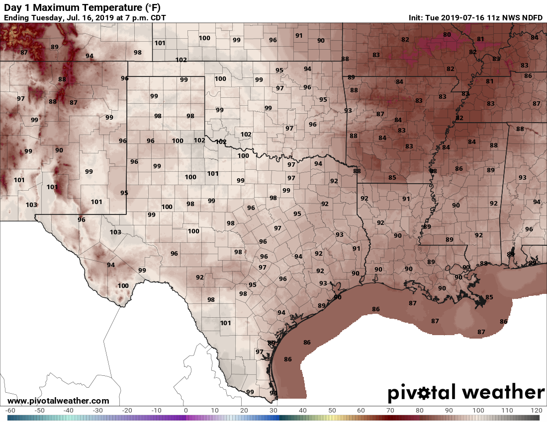
Today will be a warm one for Texas. (Weather Bell)
Wednesday
Atmospheric moisture levels remain fairly high today, but with high pressure building in it will be difficult for that surface moisture to rise and produce rain showers. So while we’ll definitely see some clouds today, I think rain showers will be isolated at best. Highs should reach into the low- to mid-90s with lots of that aforementioned humidity.
Thursday and Friday
Hot and sunny. Need we say more? OK. Highs in the low- to mid-90s. Find some shade.
Despite a tropical air mass, rain showers have been really hit or miss across the Houston region over the last four days. Some areas, like The Woodlands, have picked up 3 or more inches of rain. Other parts of south and central Harris County have received no rain at all. Pretty much everyone has seen a lot of gray skies, but that will now change as tropical moisture from former Hurricane Barry moves away, and high pressure moves into Houston.
Tuesday
Bit of a tricky forecast for today, as atmospheric moisture levels remain elevated, and high pressure really hasn’t begun to assume control of our weather just yet. However, there are no significant forcings for rainfall today, so we’re probably looking at scattered showers and thunderstorms today—not the kind of slow-moving clumps of storms we saw on Monday in areas like southern Montgomery County. A few areas may pick up a half inch of rain, or so, but most of Houston will probably remain dry. Skies otherwise should be partly sunny, with highs in the low 90s.
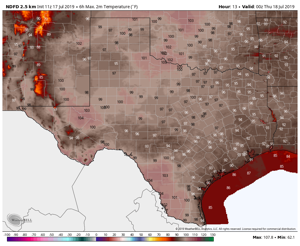
We will probably see a lot of 100-degree readings across Tuesday on Tuesday. (Pivotal Weather)
Wednesday and Thursday
As high pressure builds over the area, we should start to see mostly sunny days, with rain chances only in the 10 to 20 percent range (mostly during the afternoon, along the sea breeze). These will be prototypical July days for Houston, with lots of sunshine, and highs in the low- to mid-90s. Nighttime temperatures in the upper 70s won’t offer much relief and the humidity will add to the sultry mix.
Most of the Houston area remained dry—if cloudy—on Sunday. But the moist atmosphere in the wake of fading Tropical Depression Barry remained evident in areas such as Beaumont, which picked up 4 inches of rain. This moist atmosphere remains for one more day, and along with it the potential for heavy rainfall, before a drier pattern begins to build on Tuesday.
Monday
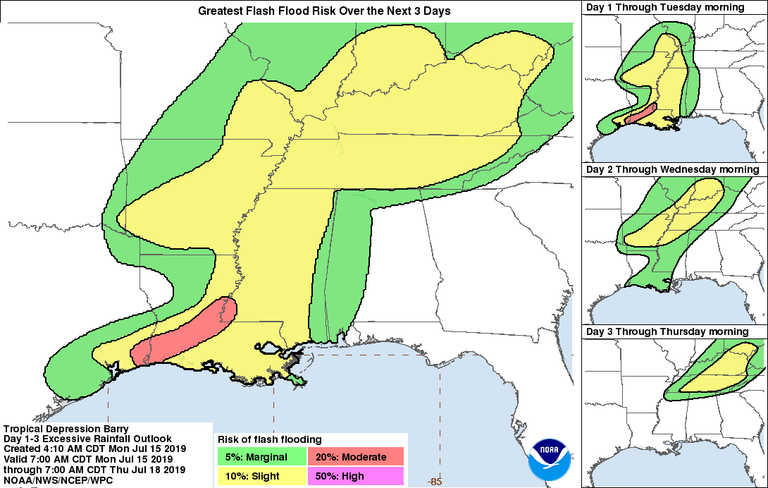
The highest risk for heavy rainfall remains east of the Houston metro area today, from Beaumont through Louisiana. Most of the city and surrounding counties will see less than one-half inch of rain. However, the eastern half of Houston remains at a slight risk of picking up an additional 1 to 3 inches of rain fairly quickly. This could cause brief street flooding in a worst case scenario. Otherwise, partly cloudy skies should help to limit temperatures in the low 90s, but alas the humidity will be oppressive.
Part of Houston faces a “slight” chance for excessive rainfall on Monday. (NOAA)
Tuesday
Rain chances will fall back to about 20 or 30 percent, as moisture levels remain fairly high in the atmosphere, but the region begins to feel the influence of high pressure. Any showers and thunderstorms that do develop should be fairly short lived. Partly to mostly sunny skies should allow high temperatures to climb back into the low- to mid-90s.
Thus far, Barry has been virtually a complete non-event here in the Houston area. We have had a few showers and some nice sunrises and sunsets but not much else. We may begin to see a bit more activity today as Barry pulls out of the Southern U.S. and a slightly more complex pattern overhead allows storms to develop.
Rest of today
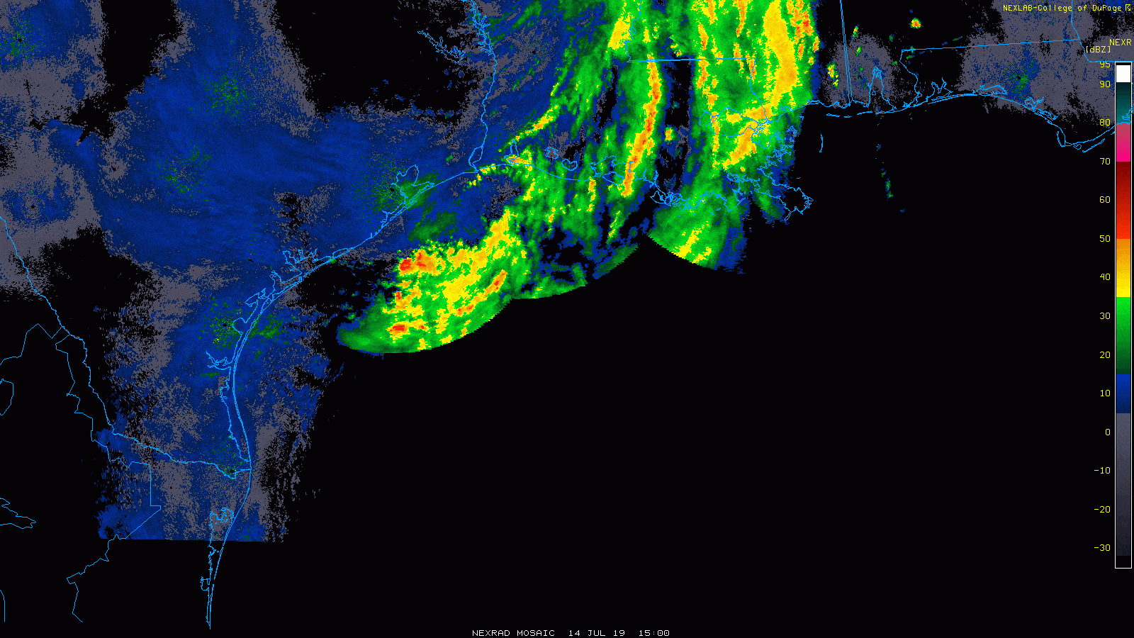
Tremendous bands of heavy rain and thunderstorms have been occurring all morning — in the Gulf of Mexico. Radar estimates 10 inches or more has fallen way out over the open Gulf, thankfully.
It’s been raining a lot — offshore. We should begin to see showers and storms develop onshore this afternoon. (College of DuPage)
That area of rain will probably begin to dissipate today and new showers and storms should begin to fire up this afternoon, especially along or southeast of US-59. Weather modeling still disagrees on exactly how this will play out, but in general, scattered showers and storms should continue off and on in that general area: Call it southern Fort Bend, southeast Harris, Brazoria, Galveston, and Chambers Counties east to Port Arthur. Rains should be manageable in most cases, but we will want to keep tabs to see if any higher rain rates can get going. If that happens, some localized street flooding would be possible. Nothing to worry over, but something to monitor through tonight.
Overnight and Monday
Additional showers and storms may continue into tonight or Monday in those same general areas mentioned above. Again, localized heavy rain will be possible. How much rain in all when this ends?
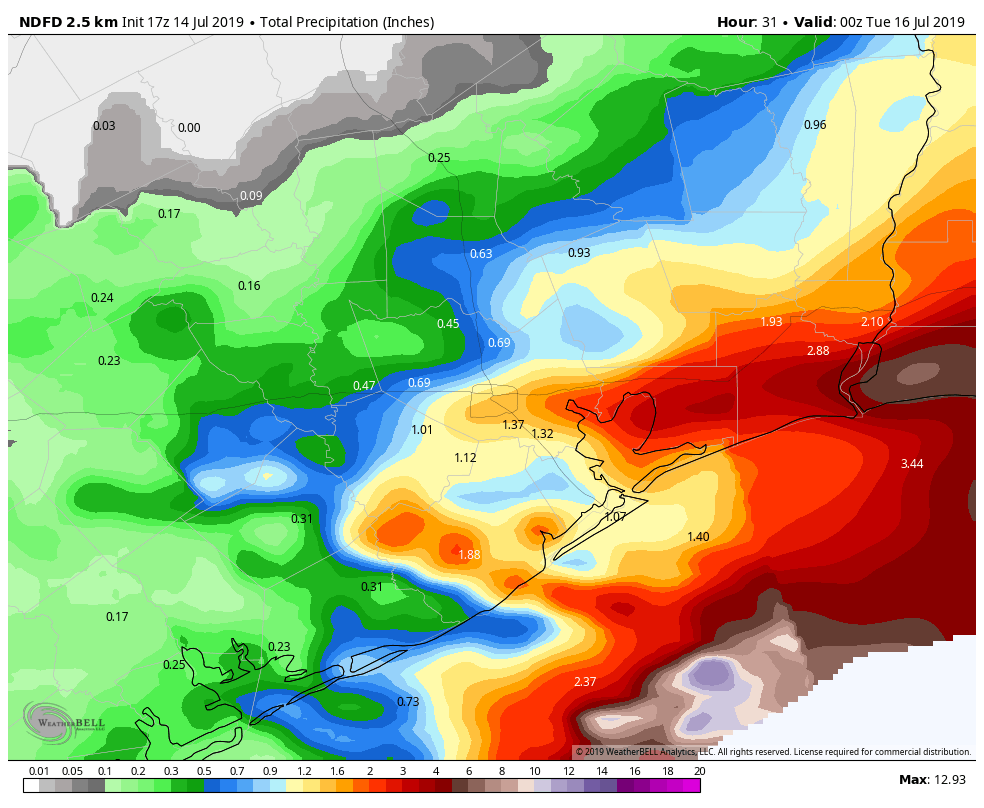
Heavier rains south and east of Houston may deposit 1 to 3 inches on average, but both higher and lower amounts are possible. (NWS via Weather Bell)
I would expect an average of 1 to 3 inches south and east of Houston, with an inch or less average north and west of Houston. Some higher and lower amounts are both possible in those areas. We will watch this through the evening and update you in the unlikely event it is needed.
For those wondering how Louisiana is faring, things have been about as good as can be hoped for so far. Flooding is ongoing in spots, but severe, widespread devastating flooding has not materialized at this point. As heavy rains continue on saturated grounds, however, some problems could begin getting more troublesome. As of this writing, one significant band of heavy rain was aimed at the Baton Rouge area and another at New Orleans (which has fared fine so far). Flooding problems will worsen south of New Orleans unfortunately, in areas that have been relatively hard hit. If anyone cares to follow details on the event, I did create a list on Twitter with local Louisiana & Mississippi meteorologists, national tropical experts, and local government agencies and media.